EGYPTIAN
ARCHAEOLOGY
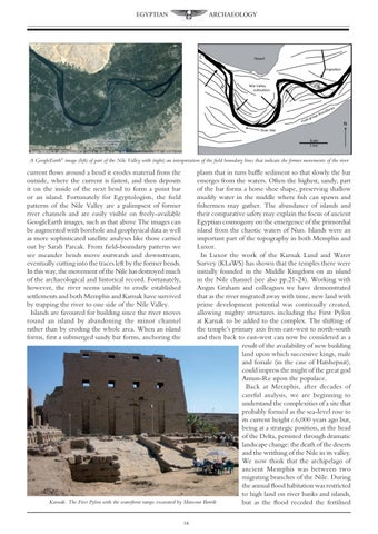
A GoogleEarth© image (left) of part of the Nile Valley with (right) an interpretation of the field boundary lines that indicate the former movements of the river
current flows around a bend it erodes material from the outside, where the current is fastest, and then deposits it on the inside of the next bend to form a point bar or an island. Fortunately for Egyptologists, the field patterns of the Nile Valley are a palimpsest of former river channels and are easily visible on freely-available GoogleEarth images, such as that above The images can be augmented with borehole and geophysical data as well as more sophisticated satellite analyses like those carried out by Sarah Parcak. From field-boundary patterns we see meander bends move outwards and downstream, eventually cutting into the traces left by the former bends. In this way, the movement of the Nile has destroyed much of the archaeological and historical record. Fortunately, however, the river seems unable to erode established settlements and both Memphis and Karnak have survived by trapping the river to one side of the Nile Valley. Islands are favoured for building since the river moves round an island by abandoning the minor channel rather than by eroding the whole area. When an island forms, first a submerged sandy bar forms, anchoring the
plants that in turn baffle sediment so that slowly the bar emerges from the waters. Often the highest, sandy, part of the bar forms a horse shoe shape, preserving shallow muddy water in the middle where fish can spawn and fishermen may gather. The abundance of islands and their comparative safety may explain the focus of ancient Egyptian cosmogony on the emergence of the primordial island from the chaotic waters of Nun. Islands were an important part of the topography in both Memphis and Luxor. In Luxor the work of the Karnak Land and Water Survey (KLaWS) has shown that the temples there were initially founded in the Middle Kingdom on an island in the Nile channel (see also pp.21-24). Working with Angus Graham and colleagues we have demonstrated that as the river migrated away with time, new land with prime development potential was continually created, allowing mighty structures including the First Pylon at Karnak to be added to the complex. The shifting of the temple’s primary axis from east-west to north-south and then back to east-west can now be considered as a result of the availability of new building land upon which successive kings, male and female (in the case of Hatshepsut), could impress the might of the great god Amun-Re upon the populace. Back at Memphis, after decades of careful analysis, we are beginning to understand the complexities of a site that probably formed as the sea-level rose to its current height c.6,000 years ago but, being at a strategic position, at the head of the Delta, persisted through dramatic landscape change: the death of the deserts and the writhing of the Nile in its valley. We now think that the archipelago of ancient Memphis was between two migrating branches of the Nile. During the annual flood habitation was restricted to high land on river banks and islands, Karnak. The First Pylon with the waterfront ramps excavated by Mansour Boreik but as the flood receded the fertilised 16