EGYPTIAN
ARCHAEOLOGY
Abydos, north cemetery Left: Detail of the magnetic map showing Middle Kingdom shaft tombs and chapels. Anomalies corresponding to Late Period vaulted tombs are marked with yellow arrows Right: Detail of the magnetic map. The arrows point to newly-discovered funerary enclosures: red – the enclosure of Aha; green – the enclosure of an unidentified ruler
and public character of the area between the lagoon and the theatre and the more private nature of the area to the east of it, characterised by an irregular street network and architecture built partly in mud-brick. The electrical resistivity method turned out to be a useful tool in clarifying individual house plans, as well as for tracing the course of particular streets in areas where a concentration of red brick, the chief building material in Pelusium, had blurred the magnetic image because of the heavily magnetic properties of this material. A number of other geophysical research projects, reported in EA, have helped to reconstruct settlement or funerary landscapes over large areas. To name but three: the DAI research in Buto (EA 24, pp.14-17), the British Museum work at Kom Firin (EA 24, pp.38-39) and the Saqqara surveys of Ian Mathieson and his team (EA 21, pp.14-16, EA 34, pp.38-39). In all cases, the conclusions have been the same: so long as the geological conditions and the character of a site are conducive to the application of geophysical methods, a decision not to carry out geophysical prospection in advance of excavation limits the possibility of understanding properly the landscape of the site and its environs. The results of geophysical surveys provide a breadth of understanding of the ancient environment which is impossible to achieve by traditional excavation methods.
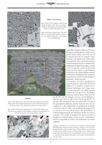
Pelusium Above: The magnetic map. The dotted yellow line marks the extent of the public quarter with monumental architecture and the red dotted line that of the private district. The solid-line box marks the area shown below Below: The resistivity map superimposed on a detail of the magnetic map. The dark linear anomalies (at right angles) correspond to the foundations of red brick constructions. The arrows indicate streets
q Tomasz Herbich is a researcher at the Institute of Archaeology and Ethnology, Polish Academy of Science and since 2011 has been Deputy Director of the Institute. From 1995 to 2000 he was Secretary General of the Polish Center of Archaeology, Cairo. Illustrations, unless otherwise indicated, © Tomasz Herbich. The writer is grateful to directors of the projects discussed in this article for permission to use the results. 14