EGYPTIAN
ARCHAEOLOGY
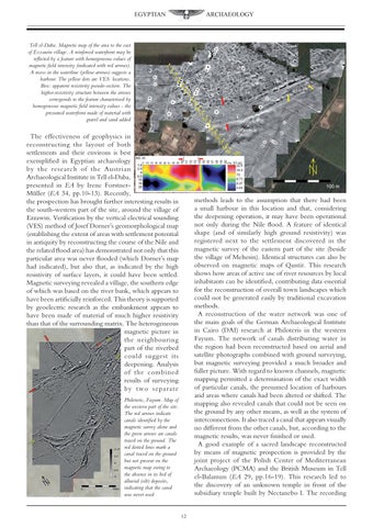
Tell el-Daba. Magnetic map of the area to the east of Ezzawin village. A reinforced waterfront may be reflected by a feature with homogeneous values of magnetic field intensity (indicated with red arrows). A recess in the waterline (yellow arrows) suggests a harbour. The yellow dots are VES locations. Box: apparent resistivity pseudo-section. The higher-resistivity structure between the arrows corresponds to the feature characterised by homogeneous magnetic field intensity values - the presumed waterfront made of material with gravel and sand added
The effectiveness of geophysics in reconstructing the layout of both settlements and their environs is best exemplified in Egyptian archaeology by the research of the Austrian Archaeological Institute in Tell el-Daba, presented in EA by Irene ForstnerMüller (EA 34, pp.10-13). Recently, the prospection has brought further interesting results in the south-western part of the site, around the village of Ezzawin. Verification by the vertical electrical sounding (VES) method of Josef Dorner’s geomorphological map (establishing the extent of areas with settlement potential in antiquity by reconstructing the course of the Nile and the related flood area) has demonstrated not only that this particular area was never flooded (which Dorner’s map had indicated), but also that, as indicated by the high resistivity of surface layers, it could have been settled. Magnetic surveying revealed a village, the southern edge of which was based on the river bank, which appears to have been artificially reinforced. This theory is supported by geoelectric research as the embankment appears to have been made of material of much higher resistivity than that of the surrounding matrix. The heterogeneous magnetic picture in the neighbouring part of the riverbed could suggest its deepening. Analysis of the combined results of surveying by two separate
methods leads to the assumption that there had been a small harbour in this location and that, considering the deepening operation, it may have been operational not only during the Nile flood. A feature of identical shape (and of similarly high ground resistivity) was registered next to the settlement discovered in the magnetic survey of the eastern part of the site (beside the village of Mehesin). Identical structures can also be observed on magnetic maps of Qantir. This research shows how areas of active use of river resources by local inhabitants can be identified, contributing data essential for the reconstruction of overall town landscapes which could not be generated easily by traditional excavation methods. A reconstruction of the water network was one of the main goals of the German Archaeological Institute in Cairo (DAI) research at Philoteris in the western Fayum. The network of canals distributing water in the region had been reconstructed based on aerial and satellite photographs combined with ground surveying, but magnetic surveying provided a much broader and fuller picture. With regard to known channels, magnetic mapping permitted a determination of the exact width of particular canals, the presumed location of harbours and areas where canals had been altered or shifted. The mapping also revealed canals that could not be seen on the ground by any other means, as well as the system of interconnections. It also traced a canal that appears visually no different from the other canals, but, according to the magnetic results, was never finished or used. A good example of a sacred landscape reconstructed by means of magnetic prospection is provided by the joint project of the Polish Center of Mediterranean Archaeology (PCMA) and the British Museum in Tell el-Balamun (EA 29, pp.16-19). This research led to the discovery of an unknown temple in front of the subsidiary temple built by Nectanebo I. The recording
Philoteris, Fayum. Map of the western part of the site. The red arrows indicate canals identified by the magnetic survey alone and the green arrows are canals traced on the ground. The red dotted lines mark a canal traced on the ground but not present on the magnetic map owing to the absence in its bed of alluvial (silt) deposits, indicating that the canal was never used
12