EGYPTIAN
ARCHAEOLOGY
Geophysical methods and landscape archaeology Archaeological geophysics has proved to be one of the most useful tools in landscape archaeology, mainly because of its potential for reconstructing diverse traces of man’s intervention in his surroundings, as Tomasz Herbich describes. In Egyptian field archaeology the dominant geophysical method is the magnetic one - the others being the electrical resistivity and georadar methods. The success of the magnetic method in Egypt is due to the presence of magnetic iron oxides in Nile silt, which has been the primary building material in the Nile Valley from antiquity through to modern times. Geophysics was used in the archaeology of the Nile Valley for the first time in the 1960s with the survey by Albert Hesse during the exploration of the fortress at Mirgissa in Nubia. This early research was extremely time-consuming because of the need both to register measurements and to plot the results manually. Low apparatus resolution meant that the only features which could then be mapped were those which were characterised by resistivity or magnetic field intensity values significantly different from their surroundings. It was not until the 1980s that fully automatic measurements permitted values to be obtained in denser grids: for the magnetic method usually no fewer than 8 points per square metre and for the electrical resistivity method 2 measurements per square metre, covering large areas counted in tens of hectares. In addition, computers provided the means for the quick processing of large amounts of measurement data, using different kinds of filters to increase the legibility of the results and varied forms of visualisation including maps and 3D models. Higher sensitivity instruments have also played a role. Despite occupying a strong position in European archaeology, archaeological geophysics was seldom used in Egyptian archaeology until relatively recently, being confined mainly to sites with a strong contrast between archaeological features and their surroundings. In the case of the magnetic method, this meant the difference between features made of magnetic Nile silt and the nonmagnetic sandy environs. Research by Helmut Becker, Joerg Fassbinder and Edgar Pusch in Qantir (see EA 14, pp.13-15) in 1996, and continued in the first years of the twenty-first century, marked a turning point in geophysical prospection. These results demonstrated the potential of the magnetic method in reconstructing the ancient urban layout and its localisation in the contemporary Delta landscape, on the bank of the now extinct Pelusiac branch of the Nile, covering an area of more than 2km2. Their
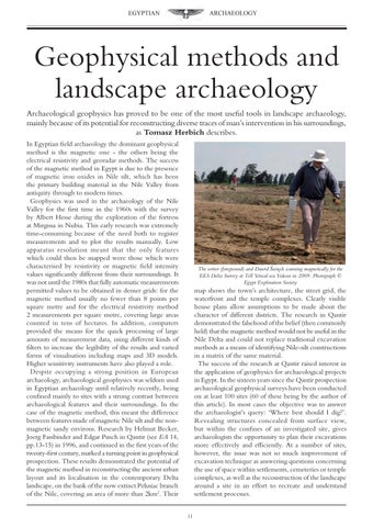
The writer (foreground) and Dawid Święch scanning magnetically for the EES Delta Survey at Tell Yetwal wa Yuksur in 2009. Photograph © Egypt Exploration Society
map shows the town’s architecture, the street grid, the waterfront and the temple complexes. Clearly visible house plans allow assumptions to be made about the character of different districts. The research in Qantir demonstrated the falsehood of the belief (then commonly held) that the magnetic method would not be useful in the Nile Delta and could not replace traditional excavation methods as a means of identifying Nile-silt constructions in a matrix of the same material. The success of the research at Qantir raised interest in the application of geophysics for archaeological projects in Egypt. In the sixteen years since the Qantir prospection archaeological geophysical surveys have been conducted on at least 100 sites (60 of these being by the author of this article). In most cases the objective was to answer the archaeologist’s query: ‘Where best should I dig?’. Revealing structures concealed from surface view, but within the confines of an investigated site, gives archaeologists the opportunity to plan their excavations more effectively and efficiently. At a number of sites, however, the issue was not so much improvement of excavation technique as answering questions concerning the use of space within settlements, cemeteries or temple complexes, as well as the reconstruction of the landscape around a site in an effort to recreate and understand settlement processes. 11