EGYPTIAN
ARCHAEOLOGY
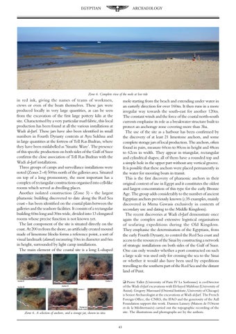
Zone 6. Complete view of the mole at low tide
in red ink, giving the names of teams of workmen, crews or even of the boats themselves. These jars were produced locally in very large quantities, as can be seen from the excavation of the first large pottery kiln at the site. Characterised by a very particular marl fabric, this local production has been found at all the various installations at Wadi al-Jarf. These jars have also been identified in small numbers in Fourth Dynasty contexts at Ayn Sukhna and in large quantities at the fortress of Tell Ras Budran, where they have been mislabelled as ‘Sinaitic Ware’. The presence of this specific production on both sides of the Gulf of Suez confirms the close association of Tell Ras Budran with the Wadi al-Jarf installations. Three groups of camps and surveillance installations were noted (Zones 2 -4) 500m north of the galleries area. Situated on top of a long promontory, the most important has a complex of rectangular constructions organised into cell-like rooms which served as dwelling places. Another isolated construction (Zone 5) - the largest pharaonic building discovered to date along the Red Sea coast - has been identified on the coastal plain between the galleries and the seashore facilities. It consists of a rectangular building 60m long and 30m wide, divided into 13 elongated rooms whose precise function is not known yet. The last component of the site is situated directly on the coast. At 200 m from the shore, an artificially created mound made of limestone blocks forms a reference point, a sort of visual landmark (alamat) measuring 10m in diameter and 6m in height, surrounded by light camp installations. The main element of the coastal site is a long L-shaped
mole starting from the beach and extending under water in an easterly direction for over 160m. It then runs in a more irregular way towards the south-east for another 120m. The constant winds and the force of the coastal north-south currents emphasise its role as a breakwater structure built to protect an anchorage zone covering more than 3ha. The use of the site as a harbour has been confirmed by the discovery of at least 21 limestone anchors, and some complete storage jars of local production. The anchors, often found in pairs, measure 60cm to 80cm in height and 48cm to 62cm in width. They appear in triangular, rectangular and cylindrical shapes; all of them have a rounded top and a simple hole in the upper part without any vertical groove. It is possible that these anchors were placed permanently in the water for mooring boats in transit. This is the first discovery of pharaonic anchors in their original context of use in Egypt and it constitutes the oldest and largest concentration of this type for the early Bronze Age. The group adds considerably to the number of ancient Egyptian anchors previously known (c.35 examples, mainly discovered in Mersa Gawasis exclusively in contexts of secondary use and dating to the Middle Kingdom). The recent discoveries at Wadi el-Jarf demonstrate once again the complex and extensive logistical organisation of seafaring expeditions during the Old Kingdom. They emphasise the determination of the Egyptians, from the early Fourth Dynasty, to control the Red Sea coast and access to the resources of the Sinai by constructing a network of strategic installations on both sides of the Gulf of Suez. One can only wonder whether a port constructed on such a large scale was used only for crossing the sea to the Sinai or whether it would also have been used by expeditions travelling to the southern part of the Red Sea and the distant land of Punt. q Pierre Tallet (University of Paris IV La Sorbonne) is co-Director of the Wadi el-Jarf excavations with El-Sayed Mahfouz (University of Assiut). Gregory Marouard (Oriental Institute, University of Chicago) is Senior Archaeologist at the excavations at Wadi al-Jarf. The French Foreign Office, the CNRS, the IFAO and the generosity of the Aall Foundation support this work. Damien Laisney (Maison de l’Orient et de la Méditerranée) carried out the topographic recording of the site. The illustrations and photographs are by the authors.
Zone 6. A selection of anchors, and a storage jar, shown in situ
43