EGYPTIAN
ARCHAEOLOGY
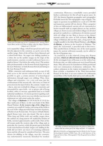
construction. However, a remarkable source provided further confirmation for this tell and its given name. In 1871 the famous Egyptian geographer and cartographer El-Falaki issued the first topographic map of Egypt. The region in question was published at a scale of 1:100.000 and numerous ancient tells are shown. Three categories of sites are differentiated: ancient tells are represented as brown mounds with an empty plateau on top, modern villages are shown in red, and modern villages on elevated ground are marked as a combination of a brown mound with red village on top. Buto is shown as two distinct mounds under the name of Tell el-Farain. While ���������� the village of Shabasia did not then exist, a long narrow tell, roughly parallel to the Bahr Masraf Nashart, called Kom el-Ahmar, is shown in the location of Shabasia. The name, the ‘red mound’, is provided only in this source. Thus another Kom el-Ahmar, one of the most popular names for ancient settlement mounds, can be added to the list of Egyptian sites. In conclusion, it is the relatively young sites, Roman and later������������������������������������������������� , ����������������������������������������������� which are affected most severely by levelling. At the investigated sites of Roman or at the earliest Late Ptolemaic date, no older settlements were found beneath them. They all seem to be foundations of that period and were not continuations of pharaonic settlements. The earliest settlement in the region investigated to date is Kom el-Asfar, a foundation of the Third Intermediate Period. So far there is no new evidence for settlements around Buto of the fourth, third and second millennia BC.
Detail of the El-Falaki map of 1871, republished 1911, showing Tell elFarain (Buto) and the site of Kom el-Ahmar, today the village of Shabasia. Original scale 1:100.000
in to expand the village, which has spread out and is now directly adjacent to the cemetery, as can be seen on the satellite image. Parts of the tell have been flattened and a school built there. An auger core drilling (marked as a white dot on the satellite image) on the slope of the south-western cemetery revealed settlement layers to a depth of about 3.5m below the surface level. The pottery dates predominantly to the Roman Period, beginning in the Late Ptolemaic or Early Roman Period and lasting to the Late Roman Period. While cemeteries and settlements built on top of tells limit access to the ancient settlements below, it is still possible to gain a certain amount of archaeological information through auger core drilling. Thus, these villages and cemeteries - in a very real sense just the continuations of the ancient tells - also serve as a form of protection for the layers below. By contrast, ‘empty’ sites - that is, sites not overbuilt by villages or cemeteries and surrounded by open fields - are at greater risk of being levelled, either to increase agricultural land or to build industrial installations. A crucial question regarding such levelled sites in the survey area was whether any traces of settlements are still extant under the surface. The village of Shabasia (31 09 54 N/30 47 59 E) lies 6km south-east of Buto, on the west bank of the Bahr Masraf Nashart. At ������������������������������������������ the western edge of the village lies a cemetery on a small tell. Surface surveying of the fields to the west of the village provided large amounts of pottery, of Early to Late Roman date. Two pieces of Early Islamic glazed Aswan ware were also found. The site is about 700m long and 300m wide and satellite images show the outlines of a long narrow tell, marked by borders of fields, oriented approximately north-south. Parts of the tell remain under the western edge of the village and, in particular, the cemetery, while the greater part in the fields to the west had been levelled. Auger core drilling in the fields did not show any traces of remaining settlement layers and the tell must be considered lost here. The area chosen for drilling in the village, near the cemetery, was unfortunately massively disturbed by modern
The village of Shabasia showing the former tell of Kom el-Ahmar (red outline) under the western part of the village and fields. © GoogleEarth q Robert Schiestl is an Egyptologist based in Berlin for the German Archaeological Institute (DAI) Cairo. He is field director of the Regional Survey Buto. Photographs © The Regional Survey Buto/ DAI Cairo.
20