EGYPTIAN
ARCHAEOLOGY
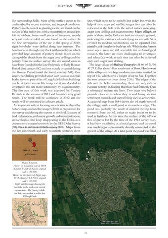
sites which seem to be entirely lost today, but with the help of these maps and satellite images they can often be relocated in the field with the aid of surface surveying, auger core drilling and magnetometry. ������������������ Many villages, or parts of them, in the Delta are built on elevated ground, indicating the existence of underlying ancient tells. Sites covered by modern constructions can be separated into partially and completely built-up tells. While in the former some open areas are still accessible for archaeological research, the latter are more challenging to investigate and subsurface work at such sites can often be achieved only with auger core drilling. The large village of Shabas Umayyir (31 06 07 N/30 47 27 E) lies about 11km south-east of Buto. ����������� North-west of the village are two large modern cemeteries situated on top of tells, which have a height of up to 5m. Together the two cemeteries cover about 2.5ha. The edges of the tells and the fields surrounding them are very rich in Roman pottery, indicating that there had formerly been a substantial ancient site here. Two maps (see below) provide clues as to when they ceased being ancient settlement mounds and started being used as cemeteries. A cadastral map from 1884 shows the tell north-west of the village, with a small pond at its southern edge. The pond was probably the result of material having been removed from the tell, either to make bricks or to be used as fertiliser. At this time the surface of the tell was free of graves but by the time of the 1913 survey map, it had been established as a burial ground and the pond was much larger – presumably directly connected to the growth of the village. At a later point the pond was filled
the surrounding fields. Most of the surface seems to be undisturbed by recent activities, and in good condition. Pottery sherds, as well as glass fragments, are found on the surface of the entire site, with concentrations around pits left by robbers. Some small pieces of limestone, mostly very soft and corroded, are also found on the surface. In the first investigation of the site in the spring of 2010, eight boreholes were drilled along two transects. The boreholes cut through very thick settlement layers which provided large amounts of pottery sherds. Based on the dating of the sherds from the auger core drillings and the pottery from the surface survey, the site would seem to have been founded in the Late Ptolemaic or Early Roman Period (first century BC) and was mainly occupied during the Roman Period (until the fourth century AD). One auger core drilling provided some Late Roman material. In the western part of the tell, regularly laid out buildings can be detected on satellite images so it was decided to investigate this site more intensively by magnetometry. The first part of this work was executed by Tomasz Herbich in the autumn of 2011 and furnished very good results. The work will be continued in 2012 and the results will be presented in a future article. An important role in locating ancient sites is played by historic maps and satellite imagery, both in preparation for the survey and during the seasons in the field. Because of land reclamation, settlement growth and industrialization, archaeological sites keep disappearing in the Delta, as is documented comprehensively by the EES Delta Survey (http://ees.ac.uk/research/delta-survey.html). Maps from the late nineteenth and early twentieth centuries show
Shabas Umayyir. Above: on a cadastral map of 1884 (District de Kafr el-Zayat), original scale 1:40.000. Below: on the Survey of Egypt map, 1913 edition (VI-1 NW), original scale 1:50.000. Right: satellite image showing the two tells in the north-west covered by cemeteries. The Survey’s drillcore holes are marked as white dots ©GoogleEarth
19