EGYPTIAN
ARCHAEOLOGY
Investigating ancient settlements around Buto
The German Archaeological Institute has been excavating the major Delta city of Buto (Tell el-Farain) since the early 1980s. In 2010 a new project was launched, directed in the field by Robert Schiestl, to survey the surrounding area and investigate settlement patterns
The site of Kom el-Gir, view to the north-west
Following the work of the EES in the 1960s at Buto, the site has been under investigation by the German Archaeological Institute (DAI), Cairo for around 30 years. This work has provided ample archaeological confirmation for the written sources referring to the important Predynastic and Early Dynastic town of Buto. The existence of the settlement in the Old Kingdom can also be documented archaeologically. The very impressive tell, which is still well preserved, is dominated by structures from the Late Period to the Roman era. What remains something of a mystery, however, is the period of about 1,500 years from the late Old Kingdom to the late Third Intermediate Period. While the temple of Wadjet seems to have been in use in the New Kingdom, so far no traces of settlement have been found at the site for the First Intermediate Period, the Middle Kingdom, the Second Intermediate Period and the New Kingdom. Based on current evidence, this major town would seem to have been abandoned for 1,500 years. As odd as this may seem from a modern perspective, the abandonment, transfer and (re-)founding of settlements, both large and small, was probably not so uncommon in ancient Egypt. However, it can be assumed that it was not done without good reason, and it is not clear what occurred at Buto or what the specific implications were of such a process for the site and the region. In 2010 a new project was, therefore, initiated by the DAI with funding provided by the Thyssen Foundation, to investigate the settlement history of the region
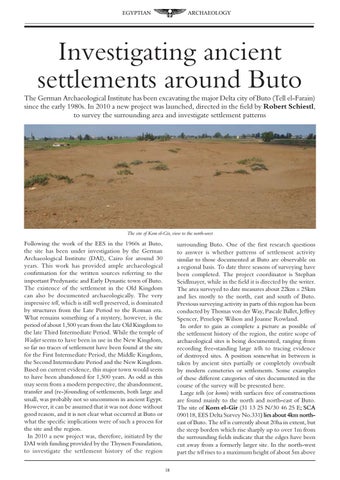
surrounding Buto. One of the first research questions to answer is whether patterns of settlement activity similar to those documented at Buto are observable on a regional basis. To date three seasons of surveying have been completed. The project coordinator is Stephan Seidlmayer, while in the field it is directed by the writer. The area surveyed to date measures about 22km x 25km and lies mostly to the north, east and south of Buto. Previous surveying activity in parts of this region has been conducted by Thomas von der Way, Pascale Ballet, Jeffrey Spencer, Penelope Wilson and Joanne Rowland. In order to gain as complete a picture as possible of the settlement history of the region, the entire scope of archaeological sites is being documented, ranging from recording free-standing large tells to tracing evidence of destroyed sites. A position somewhat in between is taken by ancient sites partially or completely overbuilt by modern cemeteries or settlements. Some examples of these different categories of sites documented in the course of the survey will be presented here. Large tells (or koms) with surfaces free of constructions are found mainly to the north and north-east of Buto. ���� The site of Kom el-Gir (31 13 25 N/30 46 25 E��; SCA 090118, EES Delta Survey No.331����������������������� ) lies ��������������������� about 4km northeast of Buto. The tell is currently about 20ha in extent, but the steep borders which rise sharply up to over 1m from the surrounding fields indicate that the edges have been cut away from a formerly larger site. In the north-west part the tell rises to a maximum height of about 5m above 18