EGYPTIAN
ARCHAEOLOGY
Workshops and urban settlement in Buto EA 24 (pp.18-19) contained a report on the 2001-06 University of Poitiers fieldwork at Buto focusing on the activities of potters at the site in the Graeco-Roman Period. Since 2007 the team has been investigating the relationship of the workshops and the city as Pascale Ballet and Gregory Marouard report. To understand the development of the settlement of Buto and to identify the different functions of the town during the latest periods of occupation, from the end of the Late Period until late Roman times, an area of 1200m2 was opened on the north-east fringe of Kom A in sector P5. This area is close to the bath building first excavated by the EES expedition, led by Veronica Seton-Williams, in the 1960s and now reinvestigated by our mission (see further p.16). The sector was partly covered by the geophysical survey conducted by Tomasz Herbich, offering the possibility of comparing the remains identified on the ground with the anomalies visible on the geophysical map. Extensive cleaning allowed us to determine the location of some pottery kilns and various buildings and, above all, to understand the history and development of this urban area in which the kilns were constructed. Deep stratigraphical trenches were made in the open areas, streets, lanes and courtyards where most of the layers and closed deposits (pits, dumps, ashes, etc.) were found. As the buildings themselves were preserved only at the level of their foundations, their occupation history had to be determined by excavating the exterior stratigraphic sequences and by investigating the domestic equipment set up outside the buildings. The ceramic evidence from these different contexts provided a chronological framework for evaluating the phases from their construction and occupation to their abandonment. Combining extensive survey work and large-scale cleaning with the excavation
Area P5. The enclosure wall and the early Ptolemaic buildings on the east slope of Kom A. View to the west during the 2009-10 excavations. Photograph: Gregory Marouard and Martin Pithon
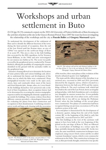
of the trenches, three main phases of the evolution of this densely urbanized quarter were highlighted. The main and the oldest element of the first phase is an enclosed area, excavated in 2009 and 2010, previously detected by the magnetic survey, which is located in a depression between the bath area (P10) and the eastern fringe of Kom A. The area’s enclosure wall, which had been built at the end of the Late Period, shows an irregular polygonal plan, with thick foundations and a circulation area alongside its exterior western face. It was probably built on the eastern side of an urban sector, and it seems possible that it was still in use during the Ptolemaic Period, when the first buildings of the second phase were constructed. Two phases of construction had been recognised during our previous excavations in P2 in the northern section of the wall. A second phase is characterised by the development of a domestic quarter, dating from the end of the fourth century BC or the beginning of the third to early first century BC, excavated between 2007 and 2010. The first buildings in the west of the enclosure wall appear to have been built at the very beginning of this period on the east slope of Kom A. They are followed by a second phase of buildings on a terrace upon the slope, probably during the third century BC. In the two cases, the same mud-brick construction techniques were employed, using concave brick courses and the so-called ‘casemate foundation’ system, which is very common for settlements in the Delta. This construction technique was not, as often previously thought, restricted to very specific
Area P5. The Ptolemaic quarter on the terrace, east part of Kom A. View to the east during the excavations of 2007-08. Photograph: Gregory Marouard and Martin Pithon
14