EGYPTIAN
ARCHAEOLOGY
Kafr es-Sheikh
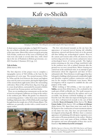
Surveying at Tell el-Daba. Over 600 points were recorded using the EES Topcon total station
The low red-coloured mounds on the site have the appearance of material moved during old sebbakhin operations, rejected and thrown back on to the ground and thus lacking any archaeological context. Areas in the eastern and western sides of the tell, however, have not been dug out to the same extent, and preserve intact archaeological layers of various periods. The highest points remaining are the ruins of large mud-brick walls in the northern area, left as isolated elements after the ground was cut away around them. Minor cleaning was carried out at the mud-brick ruins, in an attempt to gain information about the alignments and dates of these substantial walls. Their thickness would suggest that they belonged to buildings which possessed considerable height and therefore required resilient construction and they may be the remains of Ptolemaic town houses. More investigation will be required to establish the date and purpose of the walls. While working at Tell el-Daba, a visit was made to Sakha, ancient Xois (Delta Survey 10), overbuilt by the south part of Kafr es-Sheikh city. The small remnant of the ancient mound is utilized by the military and is not accessible, but Roman red-brick buildings are visible from the road. The other sites inspected during the season were three well-preserved mounds to the east of Kafr es-Sheikh: Kom el-Ganayin (Delta Survey 98), Kom Umm Gafar (Delta Survey 100) and Kom el-Ahmar (Delta Survey 99). Apart from some tests made by the SCA prior to the construction of water-treatment stations on the latter two sites, they have not previously been investigated archaeologically. All three share a common appearance of undulating tells with sparse vegetation cover and scatters of Roman potsherds on the surface. Modern cemeteries cover some parts of Kom el-Ahmar. Brief descriptions and some photographs of these sites can be found at: http://deltasurvey.tumblr.com/page/2.
A short survey season took place in April 2011 based in the city of Kafr es-Sheikh, the capital of the governorate of the same name. Most of the season was spent surveying Tell el-Daba, north-west of the town of El-Riyad, but visits were also made to several other sites, with a brief trip to the site of Naukratis in Beheira governorate, see: EES Newsletter 2 (Summer 2011) pp. 4-5. Tell el-Daba (Delta Survey 269) The first objective of the project was to complete a topographic survey of Tell el-Daba as the basis for the preparation of a new map. The mound measures 500m by 545m and the level between the lowest and highest areas varies by some seven metres, placing the highest parts of the mound about eight metres above the surrounding cultivation. Most of the tell has been dug away long ago to create deep hollows, surrounded by mounds of debris with much Late Roman pottery and fired bricks. There are no standing stone monuments on the site but at least ten red-granite millstones are lying on the surface in the southern part. Where this granite was obtained is an interesting question – either from some monumental building of pharaonic date at Tell el-Daba itself, or perhaps brought from the temple site at Tell el-Farain (Buto). The millstones are generally circular with a central round or square socket.
q Jeffrey Spencer is Director of the EES Delta Survey and Deputy Keeper of the Department of Ancient Egypt and Sudan at the British Museum, London. Photographs Š EES.
Measuring one of the millstones at Tell el-Daba