EGYPTIAN
ARCHAEOLOGY
Minufiyeh Following the unrest in Egypt in early 2011, we decided to postpone plans to take a large team to Egypt and I worked with only our ceramicist, Ashraf el-Senussi, and two Quftis. Despite having limited personnel, we were able to go ahead and investigate several sites in Minufiyeh governorate and record them for the Delta Survey. It was a good opportunity to focus on the ground survey and fieldwork, including drill coring, in the region of el-Rimaly, Sobek el-Dahak and Kom Usim. We also visited Quesna, focus of our main excavations since 2007, to collect equipment and to check the site which, fortunately, we found to be undisturbed, and made a preliminary visit to Khatatbah.
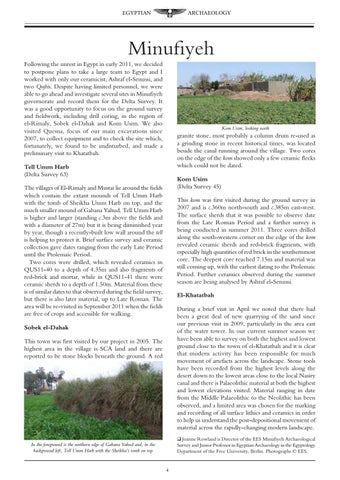
Kom Usim, looking north
granite stone, most probably a column drum re-used as a grinding stone in recent historical times, was located beside the canal running around the village. Two cores on the edge of the kom showed only a few ceramic flecks which could not be dated.
Tell Umm Harb (Delta Survey 63)
Kom Usim (Delta Survey 45)
The villages of El-Rimaly and Mustai lie around the fields which contain the extant mounds of Tell Umm Harb with the tomb of Sheikha Umm Harb on top, and the much smaller mound of Gabana Yahud. Tell Umm Harb is higher and larger (standing c.3m above the fields and with a diameter of 27m) but it is being diminished year by year, though a recently-built low wall around the tell is helping to protect it. Brief surface survey and ceramic collection gave dates ranging from the early Late Period until the Ptolemaic Period. Two cores were drilled, which revealed ceramics in QUS11-40 to a depth of 4.35m and also fragments of red-brick and mortar, while in QUS11-41 there were ceramic sherds to a depth of 1.50m. Material from these is of similar dates to that observed during the field survey, but there is also later material, up to Late Roman. The area will be re-visited in September 2011 when the fields are free of crops and accessible for walking.
This kom was first visited during the ground survey in 2007 and is c.360m north-south and c.385m east-west. The surface sherds that it was possible to observe date from the Late Roman Period and a further survey is being conducted in summer 2011. Three cores drilled along the south-western corner on the edge of the kom revealed ceramic sherds and red-brick fragments, with especially high quantities of red brick in the southernmost core. The deepest core reached 7.15m and material was still coming up, with the earliest dating to the Ptolemaic Period. Further ceramics observed during the summer season are being analysed by Ashraf el-Senussi. El-Khatatbah During a brief visit in April we noted that there had been a great deal of new quarrying of the sand since our previous visit in 2009, particularly in the area east of the water tower. In our current summer season we have been able to survey on both the highest and lowest ground close to the town of el-Khatatbah and it is clear that modern activity has been responsible for much movement of artefacts across the landscape. Stone tools have been recorded from the highest levels along the desert down to the lowest areas close to the local Nasiry canal and there is Palaeolithic material at both the highest and lowest elevations visited. Material ranging in date from the Middle Palaeolithic to the Neolithic has been observed, and a limited area was chosen for the marking and recording of all surface lithics and ceramics in order to help us understand the post-depositional movement of material across the rapidly-changing modern landscape.
Sobek el-Dahak This town was first visited by our project in 2005. The highest area in the village is SCA land and there are reported to be stone blocks beneath the ground. A red
q Joanne Rowland is Director of the EES Minufiyeh Archaeological Survey and Junior Professor in Egyptian Archaeology in the Egyptology Department of the Free University, Berlin. Photographs Š EES.
In the foreground is the northern edge of Gabana Yahud and, in the background left, Tell Umm Harb with the Sheikha’s tomb on top