EGYPTIAN
ARCHAEOLOGY
Ancient Theban waterways The EES Theban Harbours and Waterscapes Survey Project has just had its first (shortened) season. Angus Graham describes the background and aims of the project. The aim of this new EES project is to look at the ‘big picture’ of past landscapes and waterways of the Theban region and to attempt to answer very specific questions related to ancient sites in the area. Previous reconstructions of the Theban floodplain have been based on the modern river location combined with information from ancient texts and scenes from New Kingdom Theban tombs. What has been lacking, however, is a geoarchaeological and geophysical foundation to these reconstructions. Comparing maps from the Napoleonic survey to recent times reveals that the river has been migrating eastwards in the Theban area. It is, of course, today constrained by stone and concrete revetments on the east bank at Luxor and parts of the west bank. Our previous work at Karnak (see EA 27, pp.17-19 and EA 36, pp.25-28) has revealed that the earliest occupation of the area was on an island in the Nile with the eastern arm of the river subsequently silting up and the western arm migrating north-westwards, enabling the expansion of the Karnak complex of temples in the New Kingdom. On the west bank, there is archaeological, textual and pictorial evidence for platforms/tribunes in front of the New Kingdom memorial temples with associated basins and links to the river using canals. The constructions of Amenhotep III - Birket Habu on the west bank and Luxor Temple on the east - provide rough constraints for the location of the river since the Eighteenth Dynasty, suggesting that any canals in front of the memorial temples will not have been erased by the migrating river. If these canals once operated in the west bank floodplain, then our application of non-invasive geophysical techniques such as Electrical Resistivity Tomography (ERT) should be able to identify them below the present-day surface. Visits to our proposed locations of investigation during our shortened 2011 season revealed that the many
A view looking westwards to the Ramesseum shows one of the many field paths that will be ideal to work along. Photograph: Sarah Jones
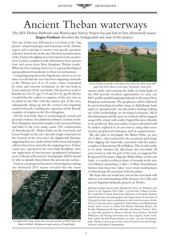
narrow paths criss-crossing the fields on both banks of the Nile provide excellent opportunities to carry out ERT profiles parallel and perpendicular to the many New Kingdom monuments. The geophysics will be followed by geoarchaeological studies using an Eijkelkamp hand auger to ‘ground-truth’ our sub-surface findings making use of the methodology we developed at Karnak. All of this information and the areas we work in will be mapped using GPS, which will enable Digital Elevation Models to be produced. Any near-surface features identified will be further explored in an area survey using other noninvasive geophysical techniques such as magnetometry. We also plan to investigate the Birket Habu, an area of c.2.4km x 1km enclosed by the enormous spoil heaps from digging the basin/lake associated with the palace complex of Amenhotep III at Malkata. This would enable us to assess whether the lake/basin was traversable all year round or only for part of the year, as suggested by Kemp and O’Connor. Opposite Birket Habu, on the east bank, is a similar rectilinear shape of mounds in the area of el-Hubeil, measuring c.1.6km x 1.05km. Ray Johnson believes that these two ‘lakes’ were ritual constructions of Amenhotep III associated with his jubilee. We hope that our work here and on the west bank will advance our understanding of the dynamic river Nile and ancient Egyptian hydraulic projects in Thebes. q Angus Graham has recently defended his thesis on ‘Harbours and Quays in the Egyptian Nile Valley’ at University College London He would like to thank Sarah Jones (Museum of London), Kristian Strutt (University of Southampton) and Ginger Emery (University of Chicago) for their expert contribution to the work this season. At the SCA in Cairo the team is grateful to Zahi Hawass and Mohammed Ismail, and in Luxor to Sultan Eid Ahmed, Moustafa Waziry, Ali Redda, Mohammed Ali Asan Hamdan and Hassan Youssef. They are especially grateful to Mansour Boreik, Ray Johnson, Richard Wilkinson and Hourig Sourouzian for their support of the work. Faten Saleh, the EES Representative in Cairo, was also of immense help. Thanks as always go to Reis Omar Farouk for his knowledge, expertise and logistical organisation
A GoogleEarth© image clearly shows the spoil mounds of Birket Habu and Birket el-Hubeil. (Background image courtesy of GoogleEarth)