EGYPTIAN
ARCHAEOLOGY
Tell Yetwal wa Yuksur As part of the ongoing work of the EES Delta Survey, Jeffrey Spencer provides a summary of recent recording at the little-known site of Tell Yetwal wa Yuksur. A full report and the magnetic map of the site are available on the Delta Survey website (www.ees.ac.uk /research/delta-survey.html). Tell Yetwal wa Yuksur is located 2km north of El-Masara and 4.8km north-west of the larger town of Bilqas, in the northern Delta. The site attracted brief attention in 1907 when part of a sarcophagus of the Late Period queen Wadjshu (probably the mother of Nectanebo II) was dug out of the mound for transfer to the Egyptian Museum in Cairo, but there is no record of any subsequent archaeological interest. This made it a candidate for the general assessment programme undertaken by the EES Delta Survey, generously funded by the British Academy. A short visit was made in 2008 to check the extent and condition of the site, following which a magnetometer survey and some trial excavations were carried out, during two short seasons, in 2009 and 2010. The mound rises to a maximum elevation of c.3m above the surrounding cultivation and measures just over 400m from north to south and c.360m from east to west. There is a small village on the eastern edge, at the end of a dirttrack from the nearby asphalt road. The surface in the higher parts of the site, towards the south end, is covered by loose dust which contains many fragments of red-brick and pottery, although most of the pottery is in a much eroded condition. An examination of the pottery revealed material from the Late Antique Period, but no certain older pieces in the accessible areas. Some fragments of red-slipped wares of around the fifth century, occasionally embellished with Christian motifs, were noted. On the surface of the site, there are also fragments of corroded bronze, glass fragments and Roman fired bricks. On old maps from the early twentieth century, the site was named Tell Kurdud, but the name had changed to Tell Yetwal wa Yuksur by 1907. This unusual name (which means ‘it gets longer and it gets shorter’) arises from a local legend which alleges that a long granite block lying on the mound varies in size over the course
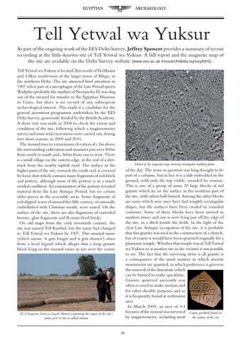
Detail of the magnetic map showing rectangular building plans
of the day. The stone in question was long thought to be part of a column, but in fact it is a slab embedded in the ground, with only the top visible, rounded by erosion. This is one of a group of some 20 large blocks of red granite which lie on the surface in the northern part of the site, with others half-buried. Among the other blocks are some which may once have had roughly rectangular shapes, but the surfaces have been eroded to rounded contours. Some of these blocks have been moved in modern times, and one is now lying just off the edge of the site, in a ditch beside the fields. In the light of the clear Late Antique occupation of the site, it is probable that this granite was used in the construction of a church, but of course it would have been quarried originally for a pharaonic temple. Whether that temple was at Tell Yetwal wa Yuksur or at another site in the vicinity is not possible to say. The fact that the surviving stone is all granite is a consequence of the usual manner in which ancient monuments are quarried, in which preference is given to the removal of the limestone which can be burned to make quicklime. Granite quarried anciently was often re-used to make mortars and for other durable purposes and so it is frequently found at settlement sites. In March 2009, an area of 4.4 hectares of the mound was surveyed Coptic potsherd found on by magnetometry, including most the surface of the site
SCA Inspector Yusri es-Sayed Ahmed explaining the origin of the site’s name next to the so-called column
33