EGYPTIAN
ARCHAEOLOGY
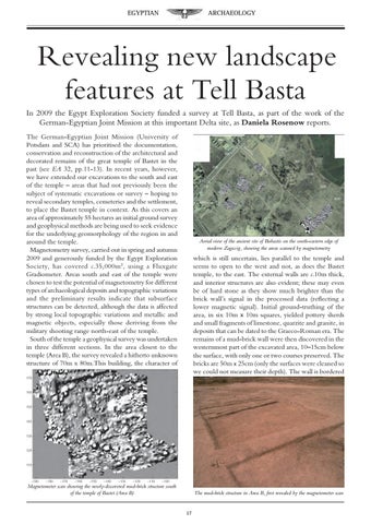
Revealing new landscape features at Tell Basta In 2009 the Egypt Exploration Society funded a survey at Tell Basta, as part of the work of the German-Egyptian Joint Mission at this important Delta site, as Daniela Rosenow reports. The German-Egyptian Joint Mission (University of Potsdam and SCA) has prioritised the documentation, conservation and reconstruction of the architectural and decorated remains of the great temple of Bastet in the past (see EA 32, pp.11-13). In recent years, however, we have extended our excavations to the south and east of the temple – areas that had not previously been the subject of systematic excavations or survey – hoping to reveal secondary temples, cemeteries and the settlement, to place the Bastet temple in context. As this covers an area of approximately 55 hectares an initial ground survey and geophysical methods are being used to seek evidence for the underlying geomorphology of the region in and around the temple. Magnetometry survey, carried out in spring and autumn 2009 and generously funded by the Egypt Exploration Society, has covered c.35,000m 2, using a Fluxgate Gradiometer. Areas south and east of the temple were chosen to test the potential of magnetometry for different types of archaeological deposits and topographic variations and the preliminary results indicate that subsurface structures can be detected, although the data is affected by strong local topographic variations and metallic and magnetic objects, especially those deriving from the military shooting range north-east of the temple. South of the temple a geophysical survey was undertaken in three different sections. In the area closest to the temple (Area B), the survey revealed a hitherto unknown structure of 70m x 80m.This building, the character of
Aerial view of the ancient site of Bubastis on the south-eastern edge of modern Zagazig, showing the areas scanned by magnetometry
which is still uncertain, lies parallel to the temple and seems to open to the west and not, as does the Bastet temple, to the east. The external walls are c.10m thick, and interior structures are also evident; these may even be of hard stone as they show much brighter than the brick wall’s signal in the processed data (reflecting a lower magnetic signal). Initial ground-truthing of the area, in six 10m x 10m squares, yielded pottery sherds and small fragments of limestone, quarzite and granite, in deposits that can be dated to the Graeco-Roman era. The remains of a mud-brick wall were then discovered in the westernmost part of the excavated area, 10–15cm below the surface, with only one or two courses preserved. The bricks are 50m x 25cm (only the surfaces were cleaned so we could not measure their depth). The wall is bordered
Magnetometer scan showing the newly-discovered mud-brick structure south of the temple of Bastet (Area B)
The mud-brick structure in Area B, first revealed by the magnetometer scan 17