EGYPTIAN
ARCHAEOLOGY
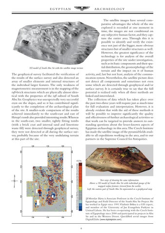
The satellite images have several comparative advantages: the whole of the site explored is recorded at one moment in time, the images are not conditional on any subjective human factor, and they capture the entire area. Through this it is possible to identify and verify the existence not just of the bigger, more obvious structures but of smaller structures as well. However, the greatest significance of the technology is for analysis of the overall properties of the site under investigation, such as its basic components and their spatial distribution, the geomorphology of the 3D model of South Abu Sir with the satellite image texture terrain and the impact on it of human The geophysical survey facilitated the verification of activity, and, last but not least, analysis of the commuthe results of the surface survey and also detected an nication system. Nevertheless, the satellite picture does array of smaller elements and internal structures of not detect all components and sometimes not even the individual larger features. The only weakness of some which are detected through geophysical and/or magnetometric measurement is in the mapping of the surface survey. It is certainly true to say that the full tafl-brick structures which are physically almost idenpotential is realised only when all three methods are tical with the properties of the tafl subsoil of South linked and interrelated. Abu Sir. Geophysics was unexpectedly very successful The collection of data which has taken place over even on the slopes, and so it has contributed signifthe past two-three years will require just as much time icantly to the completion of the archaeological plan for full evaluation and interpretation. However, it is of the site. A smaller-scale comparison of the results already evident that with the aid of these methods it achieved immediately to the south-east and east of will be possible to improve significantly the quality Hetepi’s tomb also provided interesting results.Whereas and effectiveness of further archaeological activities so in the south-east, two smaller, tightly fitting tombs that work can be targeted to provide answers to out(with a brick coat and internal sand and limestone standing questions about the lesser-known aspects of waste fill) were detected through geophysical survey, Egyptian archaeology in this area. The Czech Institute they were not detected at all during the surface surhas made the satellite image of the pyramid fields availvey, probably because of the very undulating terrain able to all expeditions working in the area, and to our at this part of the site. partners in the Supreme Council for Antiquities.
Two ways of showing the same information. Above: a 3D model of South Abu Sir with individual groups of the mapped surface features (viewed from the north). Left: the eastern part of South Abu Sir represented as a geophysical map
❑ Miroslav Bárta is Associate Professor in the Czech Institute of Egyptology and Field Director of the South Abu Sir Project. He has worked in Egypt since 1991. Vladimír BrÛna is a GIS expert, and member of the University of Jan Evangelista Purkyne in Ustinad Labem. He has been co-operating with the Czech Institute of Egyptology since 2000 and participated in projects in Abu Sir and in the Western Desert. QuickBird aerial images from DigitalGlobe ( www.digitalglobe.com ).
6