EGYPTIAN
ARCHAEOLOGY
the northern part of Saqqara to Abu Sir. At the beginning of the Fifth Dynasty, the tomb of Kaaper followed, paralleled by development at Saqqara, especially in the area north of Djoser’s tomb complex and very close to South Abu Sir.There is, as yet, no evidence for tombs of the later Fifth Dynasty in South Abu Sir, and it is highly probable that most of the non-royal tombs of the time were constructed in the pyramid field at Abu Sir itself and close by. In the middle of the Sixth Dynasty the tomb complex of the Vizier Qar and the adjacent tombs of his sons (Inti, Qar junior and Senedjemib) were constructed. These tombs gradually occupied dominant topographic locations from the south-east to north-west, which gave them a very impressive appearance. They created a south-east/ north-west axis, which respects both the natural topography of the mound and possibly the proximity of the Abu Sir Lake, which formed the main route of access to the area during the Old Kingdom. A significant contribution of the various mapping activities is the reconstruction of several ancient access routes which led to the cemetery from the Abu Sir Lake area. These routes led to the main, dominant tombs of the cemetery and are also located so as to
guarantee access both to the main parts of the cemetery and to their less frequented parts. The courses of these routes are quite distinct from natural wadis, and features which occur alongside some of them can be associated with cultic cemetery activities. Combining the evidence of the surface survey, geophysical measurement and satellite imaging gives a much better understanding of the topography of the site. The surface survey helped with the interpretation of larger features such as tombs, and identified specific structures, major burial shafts or concentrations of material such as bone fragments or pottery. Tombs were usually built of mud bricks or limestone blocks and their eroded tops leave clearly coloured traces on the surface of the desert but it is harder to identify structures built from tafl bricks, which are not markedly apparent on the surface. One other weakness of the surface survey became evident on the slopes, where features are less apparent because of geomorphological and post-depositional processes, especially washing and erosion. The survey is also subjectively affected by the optical properties of light, the season and the time of day. The same factors significantly hinder geophysical measurement and satellite monitoring, too.
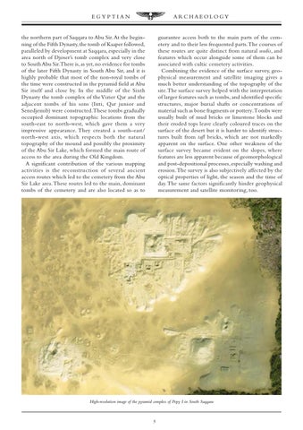
High-resolution image of the pyramid complex of Pepy I in South Saqqara
5