EGYPTIAN
ARCHAEOLOGY
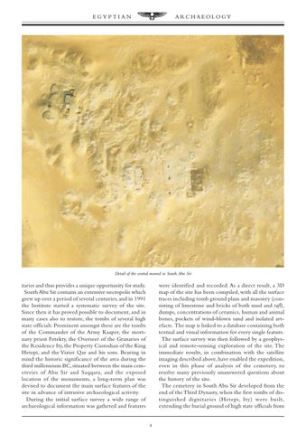
Detail of the central mound in South Abu Sir
turies and thus provides a unique opportunity for study. South Abu Sir contains an extensive necropolis which grew up over a period of several centuries, and in 1991 the Institute started a systematic survey of the site. Since then it has proved possible to document, and in many cases also to restore, the tombs of several high state officials. Prominent amongst these are the tombs of the Commander of the Army Kaaper, the mortuary priest Fetekty, the Overseer of the Granaries of the Residence Ity, the Property Custodian of the King Hetepi, and the Vizier Qar and his sons. Bearing in mind the historic significance of the area during the third millennium BC, situated between the main cemeteries of Abu Sir and Saqqara, and the exposed location of the monuments, a long-term plan was devised to document the main surface features of the site in advance of intrusive archaeological activity. During the initial surface survey a wide range of archaeological information was gathered and features
were identified and recorded. As a direct result, a 3D map of the site has been compiled, with all the surface traces including tomb ground plans and masonry (consisting of limestone and bricks of both mud and tafl), dumps, concentrations of ceramics, human and animal bones, pockets of wind-blown sand and isolated artefacts. The map is linked to a database containing both textual and visual information for every single feature. The surface survey was then followed by a geophysical and remote-sensing exploration of the site. The immediate results, in combination with the satellite imaging described above, have enabled the expedition, even in this phase of analysis of the cemetery, to resolve many previously unanswered questions about the history of the site. The cemetery in South Abu Sir developed from the end of the Third Dynasty, when the first tombs of distinguished dignitar ies (Hetepi, Ity) were built, extending the burial ground of high state officials from
4