EGYPTIAN
ARCHAEOLOGY
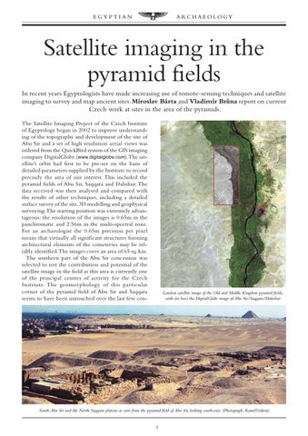
Satellite imaging in the pyramid fields In recent years Egyptologists have made increasing use of remote-sensing techniques and satellite imaging to survey and map ancient sites. Miroslav Bárta and Vladimír BrÛna report on current Czech work at sites in the area of the pyramids. The Satellite Imaging Project of the Czech Institute of Egyptology began in 2002 to improve understanding of the topography and development of the site of Abu Sir and a set of high resolution aerial views was ordered from the QuickBird system of the GIS imaging company DigitalGlobe (www.digitalglobe.com).The satellite’s orbit had first to be pre-set on the basis of detailed parameters supplied by the Institute to record precisely the area of our interest. This included the pyramid fields of Abu Sir, Saqqara and Dahshur. The data received was then analysed and compared with the results of other techniques, including a detailed surface survey of the site, 3D modelling and geophysical surveying. The starting position was extremely advantageous: the resolution of the images is 0.65m in the panchromatic and 2.56m in the multi-spectral zone. For an archaeologist the 0.65m precision per pixel means that virtually all significant structures forming architectural elements of the cemeteries may be reliably identified.The images cover an area of 65 sq. km. The southern part of the Abu Sir concession was selected to test the contribution and potential of the satellite image in the field as this area is currently one of the principal centres of activity for the Czech Institute. The geomorphology of this particular corner of the pyramid field of Abu Sir and Saqqara seems to have been untouched over the last few cen-
Landsat satellite image of the Old and Middle Kingdom pyramid fields, with (in box) the DigitalGlobe image of Abu Sir/Saqqara/Dahshur
South Abu Sir and the North Saqqara plateau as seen from the pyramid field of Abu Sir, looking south-east. (Photograph: KamilVodera)
3