EGYPTIAN
ARCHAEOLOGY
graffiti and caves occupied by anchorites. Bahariya Oasis. The IFAO expedition, directed by Frédéric Colin continued excavation of the Roman fortress in Qaret el-Tub in the sector of the church and of the principia. In addition, two intact tombs from the pharaonic cemetery were excavated; one belongs to the SIP and contained a local pottery similar to MBA II B/C types well attested in Tell el-Daba.The other tomb, in the middle of the fortress, is a complex hypogeum and cannot yet be dated. The excavation in Qasr Allam has led to the hypothesis that the site was a ‘temple’ or ‘domain’ of Amun. An enclosure has been found predating the cellular platform (see EA 24, pp.3033), while study of clay sealings has allowed the storage activities of that enclosure to be dated to the end of the TIP (terminus ante quem c.730 BC). SUMMER (May-September) Lower Egypt Tell Ras Budran: The Univ of Toronto expedition (directed by Greg Mumford and funded by the Canadian Government) continued investigations at this site (Rothenberg’s No.345) in the el-Markha plain of South Sinai. The tell is 200m W of the Red Sea and contains a sand-engulfed fort 44m in diameter, with 7m wide walls and a W entry passage flanked by a bastion. The entry passage was blockedup at both ends in antiquity, while the garrison had added a cobble stone ramp against the interior door blocking. The builders had placed a sloping retaining wall against the interior vertical wall face to support the weaker core limestone blocks. The W half of the courtyard floor was excavated and drysieved, yielding a 5-20cm thick layer of black soot and organic materials containing over 500 diagnostic OK potsherds, mainly in local Sinaitic fabrics but some (c.10%) in Nile silt. Some vessels have incised hieroglyphs and other marks. The floor also yielded nodules of copper and turquoise, a copper awl, flint tools, pounders, grinding stones, basalt hammer stones and other artefacts. Subsistence remains were found and future flotation of samples should reveal more microscopic evidence. The absence of wind-blown sand within the floor layer suggests that the fort had been occupied continuously, while the turquoise and copper nodules link the site with the known OK mines at Wadis Maghara and Kharig, 25km to the E. (www.deltasinai.com) Zawiyet Umm el-Rakham: Steven Snape and the Liverpool Univ team concentrated activities on a complete magnetometry survey of the site under the supervision of Christian Schweitzer, and the development and implementation of a conservation/ restoration plan for the site in collaboration with senior officers of the Conservation Section of the SCA. (www.geocities.com/zurdig) Saqqara: 1.The team from the Waseda Univ Institute of Egyptology, under the general direction of Sakuji Yoshimura and led in the field by Nozomu Kawai, continued work at the NW limit of the necropolis on the summit of the rocky outcrop on which the Khaemwaset monument is located, and on its S slope. Excavation in front of the 3rd Dyn layered stone structure revealed a pit with an ox-horn (probably a foundation deposit) as well as smaller pits for wooden posts or plants. A little further S, hundreds more MK pottery sherds were recovered, probably cult refuse deposits. Two test trenches opened on the SW slope of the hill yielded a number of limestone blocks from the Khaemwaset monument and more than 100 pieces of LP faience amulets from the summit of the outcrop. Restoration was undertaken at the mudbrick structure of Amenhotep II and Thutmosis IV on the top of the outcrop. 2.The Univ of Pennsylvania Museum team, directed in the field by David Silverman and Jennifer Wegner, with Josef Wegner as Director of Archaeology, worked in two areas within the vicinity of the Teti Pyramid Cemetery. Investigation of the subter-
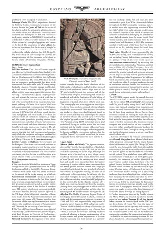
Wadi Abu Diyeiba. A sandstone anepigraphic stela. (Photograph courtesy of James Harrell)
ranean corridor from the burial chambers of the MK tombs of Sihathoripy and Sekweskhet showed that it heads southward (with a slight bend to the W) and extends beyond the temenos wall of the Teti Pyramid complex, terminating well under the mudbrick walls of the Anubieion. Careful sifting of the debris from this part of the corridor revealed 70 fragments of painted relief, most of fairly small size. The iconography and texts suggest that the majority derive from an above ground offering chapel, outside the temenos wall.Their style and execution are similar to a large inscribed fragment found in the last season, and they may all belong to the chapel of the two officials. The second focus of work was the ‘capless’ pyramid to the E and slightly N of the Teti Pyramid. Using EDM technology and a grid established during an earlier season, the area was surveyed and the visible remains of Lepsius ‘pyramid no.29’ were located, mapped and photographed. Its layout and likely proportions indicate that the satellite (‘queen’s’) pyramid would not be where originally shown, but further to the E and the S. Upper Egypt Akoris (Tehne el-Gebel): The Japanese mission, directed by Hiroyuki Kawanishi (Univ of Tsububa), continued excavation at the SW limit of the site and at the cemetery on the W edge. Although the former area is located on a steep slope, many mudbrick structures were found. Numerous seeds of ‘sont’ (acacia) used for tanning raw skin, animal hair and sandals were unearthed from the leather workshop.A number of kilns were concentrated on the lower ground. Wooden coffins and a large jar reused for burial dotted the area sparsely, all of which was covered by vegetable matting. The style of an anthropoid coffin containing the skeleton of a female adult belongs to the 22nd/23rd Dyn. However, the coffin was probably reused in the LP judging by its find context. On the W edge the existence of 11 shafts was confirmed southward from the mastaba. Among them, two pairs appeared in which one half of each was for a burial chamber and the other for funeral goods. All datable remains belong to the LP. Abydos: The Middle Cemetery Project (Univ of Michigan), directed by Janet Richards, continued study and documentation of materials excavated in 1999 and 2001, and expanded the programme of magnetic survey begun in 2002 and carried out by Tomasz Herbich (Polish Academy of Sciences). As of this season, a magnetometric map of more than 10ha (25 acres) of the Middle Cemetery has been produced, allowing a deeper understanding of its extent, nature, and spatial organisation. It is clear that the cemetery was built initially as a carefully
26
laid-out landscape in the 5th and 6th Dyns, then continued to grow S and W in a less orderly fashion throughout the FIP. Among the excavated materials studied were the fragmentary remains of Weni the Elder's (6th Dyn) serdab deposit, to determine the original contents of the serdab as opposed to elements identifiable as belonging to Saite Period reuse; skeletal remains from the intact burials N of Weni's mastaba; and skeletal remains from the extensive 'bone bed' discovered in 1999.The minimum number of individuals of the ‘bone bed’ was determined to be 50, probably from the small Saite cemetery around the top of Weni's tomb shaft. Wadi Abu Diyeiba: A team sponsored by the EGSMA and led by James Harrell (Univ of Toledo), and including Steven Sidebotham, continued the on-going survey of ancient stone quarr ies (www.eeescience.utoledo.edu/egypt/) by surveying this previously known but unstudied Ptolemaic amethyst quarry, 25km SW of Safaga. The quarry has c. 450 trenches, some as long as 100m and as deep as 20m, cut into the granite bedrock and scattered across an area of 3sq km. A badly robbed quarry settlement of c.12 buildings yielded fragments of six different Greek inscriptions, two anepigraphic stelae, an altar and an offering table, all cut from sandstone. Incised on sandstone outcrops beside the settlement are many representations of human feet. In another part of the quarry is a small (1.3m high 1.2m wide, 1.5m deep) shrine with intact granite walls and roof. Karnak: The CTEEFK projects, under the overall direction of Françcois Larché and Nicolas Grimal continued. 1. In the so-called ‘MK courtyard’, the sounding made by Jean Lauffray along the E wall of the S rooms was cleaned, revealing four superimposed courses of small limestone blocks on which is set a line of three long sandstone blocks. Two or three limestone courses are missing to reach the top of these sandstone blocks of which the upper faces are level with the four granite thresholds: the only remains of the lost monument.The limestone courses occupied the whole surface of the courtyard (as shown in earlier soundings) forming a ‘podium’ for the construction above. Geological coring has shown that the first limestone course is set on a sand layer directly above silt. 2. Recent observations by François Larché around the 4th and 5th pylons have allowed clarification of the proposed chronology for the many changes of the hall between the pylons (the ‘Wadjyt’). Cleaning of the join between the hall’s short sides and the foundation of the 5th pylon’s side walls has shown that the 5th pylon and its side walls are earlier than the 4th pylon’s. New details have been added to the reconstruction of the E faces of both pylons, particularly the existence of niches identified by Jean-François Carlotti inside the E face of the 4th pylon’s S tower has been confirmed during the restoration of the N tower by the discovery of eight seated Osirian statues of Tuthmosis I, in place inside limestone niches resting on a projecting sandstone base. A new height of four cubits has now been measured for the niches instead of the previous seven cubits. In the same hall, an architectural survey (scale 1:50) was undertaken by Emmanuel Laroze, to complete drawings already made in the central area. A topographic survey of around 1,500 points was made to support the hand drawings of the blocks.These drawings are being digitised. 3. Further excavation, directed by Aurélia Masson and Marie Millet, and research has shown that the dating of the priests’ houses E of the Sacred Lake, can now be extended back to the 21st Dyn: the door-frame of House No.1 has the name of Ankhefenkhonsu of that dynasty and ceramic evidence also points to the same date. House No.VII was excavated down to the base of its wall and its stratigraphy established the existence of seven phases. The study of the material coming from the five first phases has shown a chronological homogeneity: ce-