EGYPTIAN
ARCHAEOLOGY
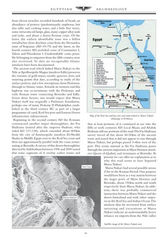
from eleven trenches recorded hundreds of beads, an abundance of pottery (predominantly amphorae, but also table and cooking wares, and a little fine ware), some terracotta oil lamps, glass, many copper alloy nails and tacks, and about a dozen Roman coins. Of the latter, the earliest identifiable issue was a billon tetradrachm (four drachma coin) from the Alexandria mint of Vespasian (AD 69-79) and the latest, in the fourth century AD, included coins of Constantine I, Valens and Theodosius I. Unidentifiable coins, possibly belonging to emperors from the fifth century, were also recovered. To date no recognisably Islamic artiefacts have been documented. The ancient road which linked Marsa Nakari to the Nile at Apollinopolis Magna (modern Edfu) preserves the remains of gold mines, nearby quarries, forts and watering points that date, according to study of the surface pottery and a few inscriptions, from Ptolemaic through to Islamic times. Towards its western end this highway was co-terminous with the Ptolemaic and early Roman route connecting Berenike and Edfu. Given these factors, one would expect that Marsa Nakari itself was originally a Ptolemaic foundation, perhaps one of many Ptolemy II Philadelphus established in the third century BC as part of a larger programme of canal, Red Sea port and Eastern Desert infrastructure enhancement. Beginning in the second century AD the Romans constructed another major thoroughfare, the Via Hadriana (named after the emperor Hadrian, who ruled AD 117-138), which extended about 800km from the city of Antinoopolis (modern El-Sheikh Ibada) in Middle Egypt over to the Red Sea coast and then ran approximately parallel with the coast, terminating at Berenike. A survey of this desert thoroughfare directed by Sidebotham between 1996 and 2000 noted that some segments of it overlay earlier routes and
Map of the Red Sea and key sites and roads related to Marsa Nakari. (Drawing: A M Hense)
that at least portions of it continued in use into the fifth or sixth centuries AD. Local Maaza and Ababda Bedouin still use portions of the road.The Via Hadriana survey traced all but about 40-50km of the ancient route and noted that it did not appear to run through Marsa Nakari, but perhaps passed 3-4km west of the port. This seems unusual as the Via Hadriana passes through the ancient emporium at Myos Hormos (modern Quseir el-Qadim) and terminates at Berenike. At present we can offer no explanation as to why this road seems to have bypassed Marsa Nakari. Marsa Nakari had several possible raisons d’être in the Roman Period. One purpose would have been as a way station between the larger ports of Myos Hormos and Berenike, about 150km north and south respectively from Marsa Nakari. In addition, there was probably commercial interaction between Marsa Nakari and the desert hinterland and with other emporia in the Red Sea and Indian Ocean.The artefacts thus far recovered from surface surveying and excavations at Marsa Nakari indicate an understandably heavy reliance on imports from the Nile valley Satellite image of the Marsa Nakari area
19