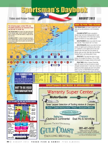
Tides and Prime Times
August 2012
USING THE PRIME TIMES CALENDAR
The following pages contain TIDE and SOLUNAR predictions for Galveston Channel (29.3166° N, 94.88° W).
T12
T4
T11
T10
TIDE PREDICTIONS are located in the upper white boxes on the Calendar Pages. Use the Correction Table below, which is keyed to 23 other tide stations, to adjust low and high tide times.
T9 T8 T7
SOLUNAR ACTIVITY is shown in the lower color boxes of the Calendar pages. Use the Solunar Adjustment Scale below to adjust times for points East and West of Galveston Channel.
T15 T16
T6 T17
T3 T2 T1
TIDE PREDICTIONS are shown in graph form, with High and Low tide predictions in text immediately below. SOLUNAR ACTIVITY data is provided to indicate major and minor feeding periods for each day, as the daily phases of the moon have varying degrees of influence on many wildlife species.
T13 T5
T14
AM & PM MINOR phases occur when the moon rises and sets. These phases last 1 to 2 hours.
T18
AM & PM MAJOR phases occur when the moon reaches its highest point overhead as well as when it is “underfoot” or at its highest point on the exact opposite side of the earth from your positoin (or literally under your feet). Most days have two Major Feeding Phases, each lasting about 2 hours.
T19
T20
PEAK DAYS: The closer the moon is to your location, the stronger the influence. FULL or NEW MOONS provide the strongest influnce of the month. PEAK TIMES: When a Solunar Period falls within 30 minutes to an hour of sunrise or sunset, anticipate increased action. A moon rise or moon set during one of these periods will cause even greater action. If a FULL or NEW MOON occurs during a Solunar Period, expect the best action of the season.
T21
Tide Correction Table
Add or subtract the time shown at the rightof the Tide Stations on this table (and map) to determine the adjustment from the time shown for Galveston Channel in the calendars.
KEY PLACE T1 Sabine Bank Lighthouse T2 Sabine Pass Jetty T3 Sabine Pass T4 Mesquite Pt, Sab. Pass T5 Galveston Bay, S. Jetty T6 Port Bolivar
NOT TO BE USED FOR NAVIGATION
HIGH -1:46 -1:26 -1:00 -0:04 -0:39 +0:14
LOW -1:31 -1:31 -1:15 -0:25 -1:05 -0:06
KEY PLACE HIGH Galveston Channel/Bays T7 Texas City Turning Basin +0:33 +3:54 T8 Eagle Point +6:05 T9 Clear Lake +10:21 T10 Morgans Point Round Pt, Trinity Bay +10:39 T11
LOW +0:41 +4:15 +6:40 +5:19 +5:15
KEY PLACE Pt Barrow, Trinity Bay T12 Gilchrist, East Bay T13 Jamaica Beach, W. Bay T14 Alligator Point, W. Bay T15 Christmas Pt T16 Galveston Pleasure Pier T17
HIGH +5:48 +3:16 +2:38 +2:39 +2:32 -1:06
LOW +4:43 +4:18 +3:31 +2:33 +2:31 -1:06
KEY PLACE San Luis Pass T18 Freeport Harbor T19 Pass Cavallo T20 Aransas Pass T21 Padre Island (So. End) T22 Port Isabel T23
HIGH -0.09 -0:44 0:00 -0:03 -0:24 +1:02
LOW -0.09 -1:02 -1:20 -1:31 -1:45 -0:42
SPORTSMAN’S DAYBOOK IS SPONSORED BY:
T22 T23
KEYS TO USING THE TIDE AND SOLUNAR GRAPHS TIDE GRAPH:
Yellow: Daylight
12a
Tab: Peak Fishing Period
6a
12p
6p
12a
Light Blue: Nighttime
BEST:
5:30 — 7:30 AM
Green: Falling Tide
Gold Fish: Best Time
Blue: Rising Tide Red Graph: Fishing Score
Blue Fish: Good Time
MINOR Feeding Periods (+/- 1.5 Hrs.) Time Moon is at its Highest Point in the Sky
SOLUNAR ACTIVITY:
12a
AM/PM Timeline
84 |
AM/PM Timeline
AM Minor: 1:20a
PM Minor: 1:45p
AM Major: 7:32a
PM Major: 7:57p
Moon Overhead: 8:50a 6a
12p
12a
Moon Underfoot: 9:15p
A u g u s t
ALMANAC Digital.indd 84
6p
2 0 1 2
MAJOR Feeding Periods (+/- 2 Hrs.) Time Moon is Directly Underfoot (at its peak on opposite side of the earth)
T e x a S
F i s h
&
G a m e ®
T F & G
A L M A N A C
7/27/12 8:53 AM