Knap of Howar On the remote northern island of Papa Westray, reached by a minute-long flight from the neighbouring Westray - the shortest flight in the world - there lies our earliest ancestral home: the Knap of Howar. Much like an earlier version of Skara Brae, the houses hunker against the wild coastline but we now know that when it was constructed - around 3800 BCE - the village was further inland protected by dunes. The lower sea levels meant the island would have been connected in a horseshoe bay to the main island of Westray. Evidence for this includes oyster shell middens oysters require sheltered bays and the current coastline is a lot more open to the elements forbidding such marine gardens. Barley and wheat grains discovered here show early farming was being practised and separate ‘workhouse’ rooms may have been used to hold livestock. The houses would have been covered by a frame made from timber or whalebone and tiled with turf weighted down with roped stones, much like the later Hebridean ‘blackhouse’ roofing. The Knap of Howar village would originally have been sheltered behind now-vanished sand dunes, echoing the situation found at Skara Brae. Inside the main house there still sits the worn barley quern or grinding stone and it looks for all the world like the family will be back at any minute, chatting away and carrying the day’s harvest home for dinner.
Skara Brae Within the broad arms of Skaill Bay on the west Mainland lies a sheltered lagoon bay which held a secret for millennia, until the sea-levels began to rise and eat into the dunes. In 1850, a great storm revealed an intricate wall system under the sands which prompted the Laird of Skaill House - a curious William Watt - to excavate a number of round stone houses with intact stone furniture. The site was eventually completely excavated by the archaeologist Gordon Childe: from 1928 to 1930 he diligently revealed a complete stone village of ten houses that we now revere as one of the world’s most perfectly preserved Neolithic jewels: Skara Brae. Radio carbon dating shows us this village was occupied between 3200 and 2200 BCE before being abandoned, possibly due to encroaching seas. The village in its day would have sat beside a fresh water lagoon behind a sheltering dune system which gave access to a rich shoreline. The village itself is embedded in sand and midden piles of discarded sea shells - this was a common Neolithic practise to shore up walls and provide insulation in winter, though to our modern sensibilities it would have reeked to high heaven! Walking round and above the village on its raised walkways, looking into the now roofless homes, it is enlightening to discover a complex architecture existing in Neolithic times to confound our prejudice of a retarded ‘Stone Age’. The sophistication of the stone furniture, the economical layout and sheltered open plan suggests a community at one with its environment, intrinsically solid and communal in spirit. The situation is so perfect and the homes so well dressed that moving in today wouldn’t seem so unattractive! Each room is connected by covered walkways and alleys. Entering the round house by a narrow doorway leads the visitor into the open centre of family life: a stone hearth in the middle with boxed bed recesses on the left and right, as well as an elegant two-tier stone dresser at the head of the house where food, clothes and valuables would have been stored. In summer on Neolithic Orkney, it is easy to imagine children running round the alleys of the houses and a modern community preparing for seasonal festivals at the nearby Ring of Brodgar and Stones of Stenness. Skara Brae shows us that despite 5000 years, not much has changed!
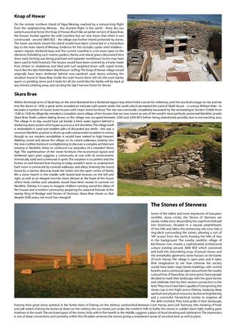
The Stones of Stenness Some of the tallest and most impressive of European neolithic stone circles, the Stones of Stenness are clearly visible once descending the road from Kirkwall into Stromness. Situated in a natural amphitheatre of low hills and lakes, this entrancing site once had a ring-ditch surrounding the stones, allowing a sort of ‘VIP access’ from the north, framing the hills of Hoy in the background. The nearby neolithic village of Barnhouse now reveals a sophisticated architectural culture existing around 3000 BCE which conceived and built this astonishing array of proud stones and the remarkably geometric stone houses on the banks of Loch Harray. The village is open plan and it takes little imagination to see how cohesive the society would have been: large family buildings with central hearths and a communal open area echoes the nearby cultural hive of Skara Brae. At some point, these people decided to mark their landscape with the giant stones and celebrate their by-then ancient connection to the land. They must have been capable of transporting the stones (up to 6m high) across Orkney, implying deep spiritual and physical resources, technical engineering and a successful hierarchical society to organise all the skills involved. They took pride in their landscape, framing their great stone symbols in the fertile heart of Orkney, on the isthmus sandwiched between Loch Harray and Loch Stenness (the meeting of fresh and salt water). Visiting the stones at dawn on the solstice, the sun travels just under the northern hills to bathe the stones in sudden dawn light, trailing giant shadows to the south. The enclosed space of the stone circle, with its fire hearth in the middle, suggests a place of ritual meaning and celebration. The impression is one of deep connections and centrality within the Orcadian universe, the stones giving a reverberant sense of ancestral time as well as place.