Biological and Environmental Monitoring
Medomak Pond
Little Medomak Pond Crawford Pond
Medo ma k
Riv
er
Seven Tree Pond
131 220 90
S t. G u So
131
th Po nd
Sidesparker Pond
Duck Puddle Pond
s ar ro w
Salt Pond Ledge
Pemaquid Harbor
New Harbor Back Little Island Cove
New Harbor Dry Ledges
ko m
Fly in
unc oo
Morse Island
ge
Long Ledge Little Franklin Ledge
Western Egg Rock
Haddock Island Kelp Ledge
dP
Ot t er Is
Little Griffen Isand St ra it
Haddock Island
Thompson Rock The Kegs
Franklin Island
Hough Ledge
Benner Island Old Hump Ledge
Midway Rocks
Johns Bay Pumpkin Pumpkin Cove Cove Ledge
South Ledge
Wash Ledge
Shark Island
Harpoon Ledge
Little Egg Rock
Old Horse Ledge Gig Rock
Griffin Ledge Davis Shoal
Davis Island
Georges Harbor
Allen Island
Eastern Egg Rock
Ledges
Seal Ledges
Egg Rock North Ledge
New Harbor Sunken Ledges
Tenants Harbor
P E N O B S C O T B AY
Mosquito Harbor
Channel Rock
Inner Shag Ledge Outer Shag Ledge
Barter Island Thompson Island
is
Devils Haddock Elbow Island Ledge
Gangway Ledge
Crane Island
Devils Back
el
Devils Limb
Harbor Island Rock
Deep Cove
Caldwell Island
Island
Toms Island
Ch an n
Ross Island
Hall Island
Harbor Island
mp
Polins Ledges Polins East Ledge
Seavey Ledges
Little Caldwell Goose Blubber Islands Rock Eagle Murray Island Island Port Clyde Teel Ledge Jenks Stone Island Harbor Drinking Cove Island Ledge Ram Hupper Island Seavey Island Mosquito Ledge Island Twobush Mosquito Bar Island Island McGee Kelp Marshall
Beyer Ship Ledge
Da v
Wreck Island Ledges
Wreck Island
Seal Harbor
Hart Ledge
Bay Cove Ledge
Goose Rock Ledge
Otter Island Ledge
Black Island Ledge
Saint George
False Whitehead Harbor
Norton Island Ledges
Long Cove
Cove
Turkey Cove
Baum Bay
Clark Island Ledge
Gay Cove
Gay Island
as s a
Round Rock
la n
Thief Island Jones Garden Island Killick Stone Garden Island Island South Ledge Black Island
Egg Rock South Ledge
Pemaquid Ledge
Friendship Long Island
Seavey Cove
Henderson Ledge Teel
Ledges Northeast Point Reef
Morse Ledge
32
Thrumcap Ledge
er
s
Gull Rock
Hu
Webber Sunken Ledge
Martin Point
Mill Cove
Wheeler Bay Rackliff Clark Bay Cove
Otis Cove
Maple Juice Cove
Crotch Garrison Sand Island Island Island Ram Island Davis Crotch Cove Island
Ol d
Long Cove
Webber Dry Ledge
Goose Riv
Th eN
g Pas sag e
el an n Ch
So un d Mus cong us
Bar Island
Cow Island
Harrington Cove
Watts Cove
Ledge
Friendship Harbor
Nubbins
Cranberry Island Otter Cedar Island Island
Island
Cutler Cove Wiley Cove Bailey
Hornbarn Cove
Hatchet Cove
Cow Island Sunken Ledges
Thrumcap Island
Browns Browns Head Head Webber North Cove Ledge Ledge
Coombs Cove Fossetts Cove
Cow Island Ledges
Jims Island
Broad Cove
97
Indian Island
Louds Island
Marsh Harbor Marsh
BrownsBar Island Cove Ledge
Friendship
Ames Cove
Crow Island
Inner Ledge
Led ge Pola nd
130
Bremen Long Island
Cow Island Dry Ledges Coombs Ledge
s
Pon d Boyd
Moxie Cove
Oar Island
Fort St. George
Island
Ho c
row eN ar
er We bb
Ke en
Hog Island Ledge
Hog Island Bar
Bristol
Wolsgrover Island
Delano Cove
ock
d Po n
ws ro ar
R
Hungry Island Wharton
Clam Island
Long Island Ledges
k
73
r ive
M ed
Pond Pe ma quid
Point Ledges
HogMiddle Ledges Palmer Island Island Crotch Islands
32
Round Pond
Locust Island
Ballyhac Cove
Nabby Cove
Cushing
Back River Northeast Cove
d
Halftide Ledge
Pitchers Cove
Havener Ledge
South Thomaston
Hyler Cove
220
Hardy Island
P on Bis ca y
N Ram er Ledges ow L
Muscongus Harbor
r ive
Ram Island
97
Long Cove
Havener Cove
Greenland Cove
131
Sampson Cove
Bens Island
R ag ke es W
Havener Pond
32
Bremen
Thomaston 1 £ ¤
Meetinghouse Cove
Broad Cove Johnson Island
Riv er
1 £ ¤
Warren
Oy ste r
Kalers Pond
LIN C OLN KNO X
Waldoboro
Pond
COU NTY COU NTY
Nor th
32
eor ge Ri v er
235
Dry Ledges
Ledge
The Brothers
Allen Ledge
Hart Island Ledges
Shag Ledges
Gunning Rocks Hart Island
Island
Barter Shoal Hay Ledge
Gunning Rock Shoal
Black Rock
Metinic Island Ledge Hupper Shoal
Old Cilley Ledge
Black Rock
Carey Rock
Little Burnt Island Burnt Island Roaring Bull
Old Woman Ledge
Little Egg Rock Shoals
Southeast Breaker
Old Man Ledge
M U S C O N G U S B AY
Haddock Ledge
Moser Ledge
Sunken Duck Rock
Duck Rocks
Eastern Duck Rock
Seal Ledges
Inner Duck Rock Deadman Cove Smutty Nose Island
Manana Island
Monhegan Harbor
Monhegan Monhegan Island
Lobster Christmas Cove Cove
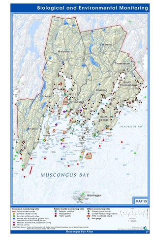
Biological monitoring sites Inshore trawl survey ! ( Juvenile lobster survey ! ( Lobster settlement index ! ( Marine bird population, growth rate, reproduction, and feeding survey ! ( Periodic marine bird population survey ! ( Urchin survey
Allen Shoal
Public health monitoring sites " ) Paralytic shellfish " ) Phytoplankton " ) Water quality
MAP 13
Gull Rock Ledge
Other monitoring sites F Climate (snow levels) G F Contaminants/Eutrophication G MITA monitored island # * Rain gauge
Miles 0
1 0
2 2
3 4
Kilometers
4 6
¢
1:150,000
Digital Data Sources: Center for Community GIS, Maine Dept. of Marine Resoures, Gulf of Maine Council on the Marine Environment, Maine Office of GIS
Muscongus Bay Atlas
Map created by: QLF- Center for Community GIS, 2008
29