Mapping Sageville Project List
KAUFMANN AV
R
Student Routes to School
E UR VE N T
CT
EDA D
R
KEY WAY DR
KE4
!& KE5 ! !& ! (9KE3 KE8 Kennedy School ! ! KE6 ! FOOTHILL RD & ! &
âââââââââââââââââ
ââââââ â ââ âââ â â â â â â â â â â â â â â â ââ â â â â â
MARTIN DR
9 School Location â â â â â â Student Bike Route to School TH
JOHN F KENNEDY RD
WEST WAY
! !
(
Heavily Traveled
Data Source: Dubuque SRTS Student Surveys, November 2008 Map prepared by East Central Intergovernmental Association
! !
KE1
R
âââââââââââââââââââ
KE2
AD
WOODLAND DR
DELMONACO DR
ST CELIA ST
ST JOHN DR
SUZANNE DR
GRAHAM CIRCLE
ST CELIA CT WEST WAY
Student Walking Route to School Lightly Traveled
DA N
600 Feet
CT
CT SL EY PA I
SOUTHWAY
LISA CT
RY RD
300
JOHN F KENNEDY RD
AS BU
150
TRYGG DR
0
A
LY D
E Kennedy Elementary School
EN
BE R
CRISSY DR
KIM
GORDON DR
BONSON RD
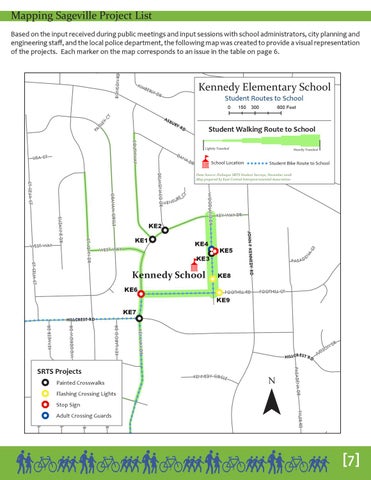
Based on the input received during public meetings and input sessions with school administrators, city planning and engineering staff, and the local police department, the following map was created to provide a visual representation of the projects. Each marker on the map corresponds to an issue in the table on page 6.
PA S A D
FOOTHILL CT
KE9
KE7
! !
â â â â â â â â â â â â â â â â ââ â â â â â â â â â â â KEY LARGO DR
WOODROW DR
Painted Crosswalks
KENNEDY CIRCLE
NORLAND DR
PHYLLRICH DR
HANSEL DR
VIZALEEA DR
¯
ND
R
TYLER RD
! ! Flashing Crossing Lights ! KEYSTONE DR & Stop Sign & ! Adult Crossing Guards ! !
H ILLCREST RD
O DS JU
PASADENA DR
SRTS Projects
KEY WAY DR
KEYMEER DR
HILLCREST RD
[7]