
24 minute read
I. DEMAND, LOCATION


1LOCATION
1. kép: A Tisza-tó látképe / Picture 1.: View of Lake Tisza
Advertisement
I IGÉNY, HELYSZÍN
1HELYSZÍN
2. kép: A 33. sz. főút keresztezése a Tisza-tavon / Picture 2.: Crossing of road number 33 on Lake Tisza

1.1. The birth of the Lake Tisza
The second largest still water of the Carpathian Basin is located on the river Tisza, at its lowland section, on the border of Jász-Nagykun-Szolnok and Heves counties .
The present appearance of the area is fundamentally determined by the work of generations of civil engineers of the earlier ages who’s work was built on each other . In the second half of the 19th century, the river regulation planned by Pál Vásárhelyi transformed the river Tisza and its surroundings, thus creating the flood protection lines that still bordering the river . Later, with the construction of the dam at Kisköre, between 1967 and 1974, the Lake Tisza was created by damming back the river – originally called the Kisköre Reservoir – and became the largest artificial lake in Hungary.
The floodplain of the reservoir is located in the section between the 404 and 440 river kilometer sections of the river Tisza, between Kisköre and Tiszabábolna, covering a total area of 127 square kilometers . The lowland area that was previously used for farming was flooded in many stages, the today’s water coverage of the lake in summer time was formed in 1978 . Since then, in the more than 40 years that have passed, a diverse, uniquely rich fauna has gradually developed with environmental conditions that are similar to the ancient Tisza floodplain landscape.
Today, large areas of open water, wetlands overgrown with swamp and seaweeds, backwaters, morotvas, natural watercourses, capes, flushing canals, islands and peninsulas make the area diverse and unique .
1.2. Parts of the Lake
Lake Tisza is divided into five larger basins: – Tiszavalk Basin – Poroszló Basin – Tiszafüred Basin – Sarud Basin – Abádszalók Basin
The water depths of the pools and bays are very varied. Next to the large, nearly flat areas, it is 0.8 m to 2 .0 m deep, the water depth of natural watercourses, backwaters and irrigation canals is between 2 .0 and 5 .0 m, and the greatest, 10–20 m depths can be measured in the main riverbed .
The internal flow system of the basins is fed by the rinsing channels, which establish the connection between the river Tisza as the main riverbed and its floodplain as a reservoir (lake). In its natural state, the coastal strip (belt reef) surrounding the riverbed is constantly filled, stands out and does not allow the refreshing water coming from the river to spread . The rinsing channels are ensuring the supply, distribution and drainage of the refreshing water to pools formed by belt reefs .
1.3.1. The topography of the area
In the surroundings of Lake Tisza, the typical altitude is between 85 and 90 m above sea level . The relative relief is of very little value, the largest level difference nowhere exceeds 2 m/square kilometres . Its northern part (Borsod floodplain) varies between 87.3 and 98.1 m above sea level . The average relative relief value here is
1.1. A Tisza-tó születése
A Kárpát-medence második legnagyobb állóvize a Tisza folyón, annak alföldi szakaszán, Jász-Nagykun-Szolnok és Heves megye határán helyezkedik el. A terület mai megjelenését alapvetően meghatározza a korábbi korok építőmérnök nemzedékeinek egymásra épülő munkássága. A XIX. század második felében a Vásárhelyi Pál által tervezett folyószabályozás formálta át a Tiszát és környezetét, létrehozva a folyót ma is határoló árvízvédelmi védvonalakat. Később a Kiskörei vízlépcső 1967 és 1974 közötti megépítésével, a folyó visszaduzzasztásával jött létre a Tisza-tó – eredeti nevén a Kiskörei víztározó – hazánk legnagyobb mesterséges tava.
A tározó hullámtere a Tisza folyó 404 és 440 folyamkilométer-szelvényei közötti szakaszon, Kisköre és Tiszabábolna között terül el, összesen 127 km2-en. A korábban gazdálkodásra használt síkvidéki területet több ütemben árasztották el, a tó mai nyári vízborítottsága 1978-ban jött létre. Az azóta eltelt több mint 40 évben fokozatosan fejlődött ki egy változatos, az ősi ártéri Tisza-tájhoz hasonló környezeti adottságokkal rendelkező, páratlanul gazdag élővilág.
Napjainkban nagy kiterjedésű nyílt vízfelületek, mocsári és hínári növényzetekkel benőtt vizes területek, holtágak, morotvák, természetes vízfolyások, fokok, öblítőcsatornák, szigetek és félszigetek tarkítják, teszik változatossá és egyedivé a területet.
1.2. A tó részei
A Tisza-tó öt nagyobb medencére tagolódik: – Tiszavalki-medence, – Poroszlói-medence, – Tiszafüredi-medence, – Sarudi-medence, – Abádszalóki-medence.
A medencék és öblözetek vízmélysége igen változatos. A nagy kiterjedésű, közel sík területeken 0,8 m–2,0 m, a természetes vízfolyások, holtágak és öblítőcsatornák vízmélysége 2,0–5,0 m közötti, a legnagyobb mélységek pedig a főmederben mérhetőek, 10–20 m.
A medencék belső áramlási rendszerét az öblítőcsatornák táplálják, melyek megteremtik a kapcsolatot a Tisza folyó, mint főmeder és hullámtere, mint tározótér (tó) között. A medret övező parti sáv (övzátony) természetes állapotában folyamatosan töltődik, kiemelkedik, és nem teszi lehetővé a folyón érkező frissítő víz szétterülését. Az öblítőcsatornák a frissítő víz bejuttatását, szétosztását, ill. elvezetését biztosítják az övzátonyokkal kirekesztett medencékbe.
1.3. A tó környezeti jellemzői
1.3.1. A terület domborzati adottságai
A Tisza-tó környezetében 85 és 90 m közötti tszf-i magasság a jellemző. A relatív relief nagyon kis értékű, a legnagyobb szintkülönbség a 2 m/km2-t sehol sem haladja meg. Északi (Borsodi ártér) része 87,3 és 98,1 m tszf között változik. Az átlagos relatív relief értéke itt 1 m/km2. A felszín legnagyobb része alacsony ártéri és ármentes síkság, északi részén ármentes részekkel tagolt, de egészében ártéri szintű tökéletes síkság.
1.3.2. Vízrajzi jellemzők
A Tisza-tó mesterséges létesítmény, lényegében egy átfolyásos tározó, szintjének helyzete a folyó mindenkori vízjárásának is függvénye. A duzzasztómű csak a kiskörei szelvényben tartja a vízszintet egy adott intervallumon belül, a tározó felszínének esése az érkező vízhozamtól függ.
1 m/square kilometer. Most of the surface is low floodplain and flood-free plain areas, In it’s northern part, it is divided by flood-free parts, but on the whole floodplain level, a perfect plain .
1.3.2. Hydrographic characteristics
Lake Tisza is an artificial facility, essentially a flowthrough reservoir, the position of it’s water level also depends on the current stream of the river . The dam keeps the water level within a certain interval only in the Kisköre section, the hang of the reservoir surface depends on the flow of the incoming water.
A special feature of the lake is that its stream is controllable. The river Tisza flows through the reservoir area in an independent riverbed – the main riverbed or the so-called mother riverbed . Parallel to the main riverbed, to its right and left, is the line of belt reefs — these form the system of islands and peninsulas — that separates the riverbed from the reservoir basins .
The current volume of the reservoir is 253 million cubic metres, of which 132 million cubic metres can be utilized .
The most important facilities of the water distribution network of the water supply are the main irriga-

3. kép: Madárvilág / Picture 3 .: Birdlife tion canals of Jászság (with a capacity: 48 m3/sec) and Nagykunság (with a capacity: 80 m3/sec), which ensure the supply of irrigation water and the refillment of fishponds in the surrounding areas . In addition to satisfying agricultural water needs, the Nagykunság main canal, by gravity water transmission plays a major role in alleviating the water shortage and ecological water replenishment of the Körös Valley .
1.3.3. The water protection of Lake Tisza
Lake Tisza is the second largest lake in Hungary, which belongs to the Nagykunság subunit from the point of view of the river’s drainage basin management . The living river Tisza flows through the lake on a 33 km long section . In the vicinity of Lake Tisza a numerous designated water base protecting defender areas/defender profiles can be found.
1.3.4. Wildlife
The first protected area of Lake Tisza is the Tiszafüred Bird Sanctuary situated in the Valki Basin, which was established in 1972 on 3,400 hectares . The nature conservation area was declared as the part of the Hortobágy National Park in 1993, and it was expanded by 3,600 hectares by declaring the Poroszló and Sarudi basins partially protected . Protected natural areas of national importance are also so-called wetlands of international importance that are covered by the Ramsar Convention, and as part of the Hortobágy National Park, they have been a UNESCO World Heritage Site since 1999 . The entire area of Lake Tisza is part of the European Union’s nature conservation network, the so-called Natura 2000 network, as a priority nature conservation and special bird protection area .
A tó sajátossága, hogy vízjárása szabályozható. A Tisza folyó önálló mederben – főmeder, vagy úgynevezett anyameder – folyik át a tározótéren. A főmederrel párhuzamosan, annak jobb és bal oldalán húzódik az övzátonyok vonulata – ezek alkotják a szigetek és félszigetek rendszerét –, amely elválasztja a folyó medrét a tározó medencéitől. A tározó jelenlegi térfogata 253 millió m3, melyből 132 millió m3 hasznosítható.
A vízkészlet vízelosztó hálózatának legfontosabb létesítményei a Jászsági (kapacitása: 48 m³/sec) és a Nagykunsági (kapacitása: 80 m3/sec) öntöző főcsatornák, amelyek biztosítják a környező térségek öntözővíz ellátását és halastavi vízpótlását. A Nagykunsági főcsatorna a mezőgazdasági vízigények kielégítése mellett, gravitációs átvezetéssel nagy szerepet játszik a Körös-völgy vízhiányának enyhítésében és ökológiai vízpótlásában.
1.3.3. A Tisza-tó vízvédelmi bemutatása
A Tisza-tó Magyarország második legnagyobb tava, amely vízgyűjtő-gazdálkodási szempontból a Nagykunsági alegységhez tartozik. A tóban egy 33 km-es szakaszon folyik át az élő Tisza. A Tisza-tó környezetében számos kijelölt, vízbázis-védelmi védőterület/védőidom található.
1.3.4. Élővilág
A Tisza-tó első védett területe a Valki-medencében elhelyezkedő tiszafüredi madárrezervátum, melyet 1972ben alapítottak 3400 hektáron. A természetvédelmi területet 1993-ban a Hortobágyi Nemzeti Park részévé nyilvánították, majd 3600 hektárral kibővítették a Poroszlói- és Sarudi-medencék részleges védetté nyilvánításával. Az országos jelentőségű védett természeti területek egyben a Ramsari Egyezmény hatálya alá tartozó, ún. nemzetközi jelentőségű vizes élőhelyek, valamint a Hortobágyi Nemzeti Park részeként 1999 óta az UNESCO világörökség részei. A Tisza-tó egész területe az Európai Unió természetvédelmi hálózatába, az ún. Natura 2000 hálózatba tartozik, mint kiemelt jelentőségű természet-megőrzési és különleges madárvédelmi terület.
A tó egyes részei emellett a Hortobágyi Nemzeti Park bemutatóterületei.
4–5. kép: Madárvilág / Picture 4–5 .: Birdlife

Besides this, some parts of the lake are also demonstration areas of the Hortobágy National Park .
The lake hides a unique world of the wild water, attracting hikers and tourists to an adventurous journey, offering different leisure time opportunities in every season . We can choose between routes and explore the countryside on foot, by bike, on horseback, or even by boat throughout the whole year .
Thanks to the diverse habitats and mosaic-like structure of Lake Tisza, a very rich fauna has developed here . They are accounting 14 types of plant associations in its territory .
Along the cycle path, the number of natural and natural-like habitats is small . Starting from Poroszló, the open water is mainly characterized by seaweed associations formed by fringed water lily, white water lily, yellow pond-lily and water caltrop . Common species in the shallower parts are diamond milfoil, bladderwort, common club-rush and flowering rush. A narrow strip along the shores is occupied by broadleaf cattails and reeds . The dominant species in the wooded areas is the native white poplar and white willow, but along the bike path, alien invasive species such as green ash, boxelder maple, or false indigo bush have also spread . The undergrowth of floodplain forests is poorer, but the protected summer snowflake occur in several places.
The fish fauna of Lake Tisza is extremely rich, with more than 50 species known to occur, of which the bream, carp, silver carp, fluvial catfish and pike are common . Fishing is allowed in accordance with the rules .
The most common amphibians are marsh frogs, pool frogs and edible frogs, but European fire-bellied toads and European tree frogs are also common, while the Danube crested newt is rarely seen . Reptiles are represented by the grass snake and the European pond turtle .
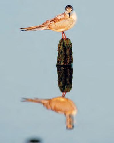
Lake Tisza is a significant bird habitat in all seasons, with more than 200 species observed in and around the lake . In spring and summer, nesting birds cover the lake . The heron colony of the Tiszafüred Bird Sanctuary is unique, in which the pygmy cormorant, little egret, great egret, gray heron, black-crowned night heron nest. The undisturbed floodplain forests are nested by the white-tailed eagle, the black kite and the black stork . In addition to nesting, the lake also plays a prominent role in bird migration . Hundreds of thousands of water birds visit the lake in autumn and winter . In addition to the masses of wild ducks and great white-fronted gooses, Lake Tisza plays a prominent role in the migration of common pochards, tufted ducks and common goldeneyes, but the highly protected red-breasted goose is also resting in increasing numbers on the lake . The presence of velvet ducks or velvet scoters, which cross the lake are sporadic in Hungary, and are unique in relation to the Great Plain . Along the cycle path, many bird species can be observed from close on the Lake Tisza Water Promenade and Educational Trail . Singing birds and bearded reedlings live in the reeds, and almost all water birds on the lake occur along the open waters . Typical bird species of the domestic summers along the trail are the common wood pigeon, the great spotted woodpecker, the Eurasian blackcap, the common chiffchaff and the great tit .
Among mammals, the retreating beaver is becoming more common in the area, but otters and wildcats also occur . In the bumpier parts, on islands, roe deers and wild boars have also found favorable conditions for their living .
A tó páratlan vadvízi világot rejt, kalandos utazásra csábítva a természetjárókat, minden évszakban más és más szabadidős lehetőséget kínálva. Egész évben válogathatunk az útvonalak között, és bejárhatjuk a vidéket gyalog, kerékpárral, lóháton, vagy akár csónakba is szállva.
A Tisza-tó változatos élőhelyeinek, mozaikosságának köszönhetően igen gazdag élővilág alakult ki. Területén 14-féle növénytársulást tartanak számon. A kerékpárút mentén a természetes, illetve természetszerű élőhelyek száma csekély. Poroszlóról indulva a nyílt vízen elsősorban tündérfátyol, fehér tündérrózsa, vízitök és sulyom alkotta hínártársulások a jellemzőek. A sekélyebb részek elterjedt fajai a süllőhínár, a közönséges rence, a tavi káka és a virágkáka. A partok mentén keskeny sávot foglal el a széleslevelű gyékény és a nád. A fával borított területek domináns faja az őshonos fehér nyár és fehér fűz, de a kerékpárút mentén elterjedtek a tájidegen invazív fajok is, mint az amerikai kőris, a zöld juhar vagy a gyalogakác. Az ártéri erdők aljnövényzete szegényes, de több helyen előfordul a védett nyári tőzike.
A Tisza-tó halfaunája rendkívül gazdag, több mint 50 faj előfordulása ismert, melyek közül elterjedt a dévérkeszeg, a nyurga ponty, az ezüst kárász, a folyami harcsa és a csuka. A horgászat a szabályok betartása mellett engedélyezett.
Kétéltűek közül leggyakoribb a tavi, kis tavi és kecskebéka, de elterjedt a vöröshasú unka és a zöld levelibéka is, míg a dunai tarajosgőte ritkán kerül szem elé. A hüllőket a vízisikló és a mocsári teknős képviseli.
A Tisza-tó minden évszakban jelentős madárélőhely, a tavon és környékén több mint 200 fajt figyeltek meg. Tavasszal és nyáron a fészkelő madarak lepik el a tavat. Egyedülálló a tiszafüredi madárrezervátum gémtelepe, melyben fészkel a kis kárókatona, kis kócsag, nagy kócsag, szürke gém, bakcsó. A háborítatlan ártéri erdők fészkelője a rétisas, a barna kánya és a fekete gólya. A fészkelésen túl a tó szerepe a madárvonulásban is kiemelkedő. Ősszel és télen vízimadarak százezrei keresik fel a tavat. A tőkés récék és nagy lilikek tömegei mellett a Tisza-tónak kiemelkedő szerepe van a barát-, kontyos és kercerécék vonulásában, de a fokozottan védett vörösnyakú lúd is egyre nagyobb számban pihen meg a tavon. Alföldi viszonylatban egyedülálló a tavon átvonuló, hazánkban szórványosan előforduló búvárok vagy füstös récék jelenléte. A kerékpárút mentén a Tisza-tavi Vízi Sétányon és Tanösvényen számos madárfaj közelről is megfigyelhető. A nádasokban nádi énekesek és barkóscinegék élnek, a nyílt vizek mentén pedig a tavon előforduló szinte összes vízimadár előfordul. A nyomvonal menti hazai nyarasok jellemző madárfajai az örvös galamb, a nagy fakopáncs, a barátposzáta, a csilpcsaplfüzike és a széncinege.
Emlősök közül a visszatelepülő hód egyre gyakoribb a területen, de előfordul a vidra és a vadmacska is. A hátasabb részeken, szigeteken az őzek és vaddisznók is megtalálták az élőhelyeik kedvező feltételeit.

6. kép: A rejtőzködő életmódú hód / Picture 6: Beaver with hiding lifestyle
2HISTORY 3 THE PURPOSE OF THE CONSTRUCTION
The investment No . K033 .08 PST . of the NIF National Infrastructure Development Zrt ., in the construction of the main contractor of Hódút Kft ., was based on the development of bicycle traffic between 2017–2020 ordered by the Lake Tisza Tourism Development Association’s given project plans of the Permit design plans developed by TANDEM Mérnökiroda Kft . in the project that’s code was ÉAOP-2 .1 .1/E-12-K1-2012-0009 on the topic of “Competitive tourism product and attraction development” and the project that’s code was ÉMOP2 .1 .1/A-12-K1-2012-0008 on the topic of “Competitive tourism product and attraction development” . Permit design plans and construction plans were preceded by several study plans, which primarily examined the optimal buildability of the structures and the cycle path . The entire investment program includes a 42 km long path for bicycle traffic with four new bridges on the Poroszló– Tiszafüred–Fishponds of Hortobágy route . The basic purpose was to create the conditions of safe cycling along the main road No . 33 . between Poroszló and Tiszafüred, connecting the existing operating bicycle traffic facilities around Lake Tisza between the western and eastern shores . The expected result after the implementation was exempting the main road No . 33. from cycling traffic, and by this, the increasing traffic safety. The built facility serves the needs of the region for both tourism and professional cycling .
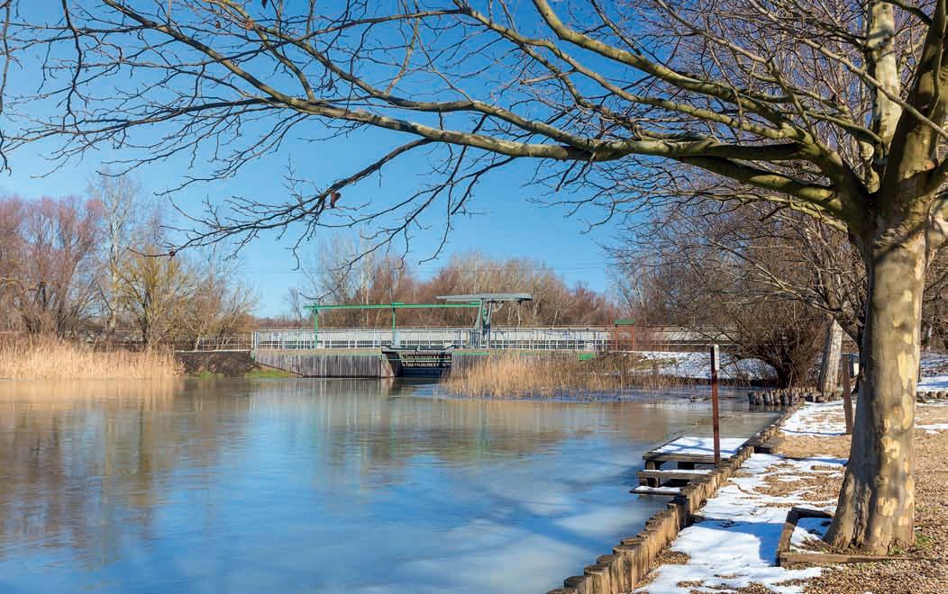
7. kép: A Tisza-tó vízfelülete Poroszló mellett az elkészült Eger-híddal / Picture 7 .: The water surface of Lake Tisza near Poroszló

2ELŐZMÉNYEK 3 AZ ÉPÍTÉS CÉLJA
A NIF Nemzeti Infrastruktúra Fejlesztő Zrt. K033.08 PST. számú beruházásában, a Hódút Kft. Fővállalkozói kivitelezésében 2017–2020 között megvalósuló kerékpárforgalmi fejlesztés alapját a Tisza-Tavi Turizmus Fejlesztő Egyesület megbízásából a TANDEM Mérnökiroda Kft. által készített a „Versenyképes turisztikai termék- és attrakciófejlesztés” tárgyú ÉAOP-2.1.1/E12-K1-2012-0009 kódszámú projektben kidolgozott engedélyezési tervei és a „Versenyképes turisztikai termék- és attrakciófejlesztés” tárgyú ÉMOP-2.1.1/A12-K1-2012-0008 kódszámú projekt tervei adták. Az engedélyezési és kiviteli terveket több tanulmányterv előzte meg, melyek elsősorban a műtárgyak és a kerékpárút nyomvonal optimális megépíthetőségét vizsgálták. A teljes beruházási program a Poroszló–Tiszafüred–Hortobágyi halastavak útvonalon, mintegy 42 km hosszúságú kerékpárforgalmi nyomvonalat tartalmaz négy új híddal. Alapvető cél a biztonságos kerékpáros közlekedés feltételeinek megteremtése volt a 33. sz. főút mentén Poroszló és Tiszafüred között, csatlakoztatva a Tisza-tó körül már meglévő, üzemelő kerékpárforgalmi létesítményeket a nyugati és a keleti partok között. A megvalósítás után elvárt eredmény a 33. sz. főút kerékpáros-forgalomtól való mentesítése, ezáltal a forgalombiztonság növelése. A megépült létesítmény a térség turisztikai és hivatásforgalmi kerékpáros igényeit egyaránt szolgálja.

more than 4 .4 km long road, besides the two-way cycle path, two independent bridge structures were built, and a completely new drainage system has been implemented between the slope of the main road and the planned cycle path .
The first section of the facility belongs to the Northern Hungary Region and is located in Heves County . The cycle path starts in the administrative area of Poroszló, from the top of the flood protection embankment of the Eger creek, outside a populated area, as a continuation of the asphalt-paved cycling route already established on the flood defense embankment. Leaving the embankment on the south side of the main road No . 33 ., the first and also the one of the most impressive structures of the trail is the new bicycle bridge of the Eger creek . After that, the bike path continues almost parallel to the main road towards Tiszafüred . The topographical line drawing of the path uses the asphalt-paved road of the previous and already abandoned main road No . 33 ., which was available in a significant length at the southern side of the existing embankment . The implemented two-way bicycle path between the Eger creek and the Szomorka creek was built using the existing abandoned road . And due to the watercourse crossings, new roadway sections were built, that lead up to the bridges . From the Szomorka creek to the Kis-Tisza flood gate, the cycle path was also built on the abandoned pavement of the available old main road No . 33, with road reconstruction. And from the Kis-Tisza flood gate, to the plant facility at the 32 + 520 km section area of the main road No . 33 ., an industrialroad was established, partly with a new track structure and partly with road reconstruction . In front of the building of the Fehér Amur Fisherman’s Tavern at the northern end of the Tisza Bridge, the cycling trail is slightly moving away from the road, leaving room for the double-sided retaining wall, that is built into the surface of the existing sloping . On the
5THE SECTION BETWEEN THE TISZA BRIDGE AND TISZAFÜRED
The trail belongs to the Northern Great Plain Region and is located in Jász-Nagykun-Szolnok county . Connecting to the structure of the new cycling Tisza Bridge, the cycle path starts with a section supported by a retaining wall . The planned route, after the cycling Tisza Bridge follows the topographical design of the main road No . 33 . , similarly to the section before the river Tisza, with a nearly parallel line, as an independent two-way cycle path . The end of the independent bicycle path is the industrial road next to the main road in the area of the 3+645 km section . This more than 300 m long mixed-use section, was built as an industrial road of the Central Tisza Region Water Directorate in a way, that it is also suitable for the periodic loads of maintenance vehicles and high axle load heavy-duty vehicles used for moving of logging material . The section is connected to the u-turn road for oversized vehicles (it is a parking lot, which also serves as a rest area, according to the daily traffic schedule). Following parallel the trail of the main road No. 33. (on the counter berm) we reach the border of Tiszafüred . Then, a little further away from the main road No . 33, we arrive on a short embankment to the flood gate structure called flushing channel No . X ., which is bridged by a new, “Dutch type” openable bridge structure . After the structure, the cycle path reaches the area in front of the Tisza Balneum Thermal
4POROSZLÓ – TISZA-HÍD KÖZÖTTI SZAKASZ 5 TISZA-HÍD– TISZAFÜRED KÖZÖTTI SZAKASZ
A létesítmény első szakasza területileg az Észak-Magyarországi Régióhoz tartozik és Heves megyében található. A kerékpárút Poroszló közigazgatási területén, az Eger-patak árvédelmi töltésének tetejéről, lakott területen kívül indul, folytatásaként az árvédelmi töltésen már korábban kialakított aszfaltburkolatú kerékpáros útvonalnak. A töltést a 33. sz. főút déli oldalán elhagyva a nyomvonal első és egyből egyik legimpozánsabb építménye az Eger-patak új kerékpároshídja. Ezt követően a kerékpárút a főúttal közel párhuzamosan halad tovább Tiszafüred felé. A helyszínrajzi vonalvezetés kihasználta a korábbi és már felhagyott 33. sz. főút aszfaltburkolatú útpályáját, mely a meglévő töltés déli oldali lábánál jelentős hosszban rendelkezésre állt. A kialakított kétirányú kerékpárút, az Eger-patakot és a Szomorka-patakot áthaladó kerékpároshidak között, a meglévő, felhagyott útpályát hasznosítva épült. A vízfolyás-keresztezések környezetében pedig új, a hidakra felvezető útpályaszakaszok készültek. A Szomorka-pataktól a Kis-Tiszazsilipig a szintén a rendelkezésre álló régi 33. sz. főút felhagyott burkolatán útpálya-rekonstrukcióval építették ki a kerékpárutat. A Kis-Tisza-zsiliptől a 33. sz. főút 32+520 kmsz. térségében lévő üzemi létesítményig pedig üzemi út létesült részben új pályaszerkezettel, részben pedig útpálya-rekonstrukcióval. A Tisza-híd északi hídfőjénél található Fehér Amur Halászcsárda épülete előtt a kerékpáros nyomvonal kissé eltávolodik a közút mellől, helyet hagyva a meglévő rézsű felületébe épített kétoldali támfalas megtámasztásnak. A több, mint 4,4 km hosszú nyomvonalon a kétirányú kerékpárút mellett két önálló hídműtárgy épült, valamint a főút rézsűje és a tervezett kerékpárút között teljesen új vízelvezető rendszer valósult meg. A nyomvonal területileg az Észak-Alföldi Régióhoz tartozik és Jász-Nagykun-Szolnok megyében található. Az új kerékpáros Tisza-híd hídszerkezetéhez csatlakozóan a kerékpárút támfalas megtámasztású szakasszal indul. A tervezett nyomvonal a kerékpáros Tisza-híd után követi a 33. sz. főút helyszínrajzi kialakítását, hasonlóan a Tisza előtti szakaszhoz, közel párhuzamos vonalvezetéssel, önálló kétirányú kerékpárút jelleggel. Az önálló kerékpárút vége a főút mellett található üzemi út a 3+645 km-szelvény környezetében. Ez a több, mint 300 m hosszú, vegyes használatú szakasz a KözépTisza-vidéki Vízügyi Igazgatóság üzemi útjaként épült ki úgy, hogy az alkalmas a fenntartó járművek és a fakitermelés anyagkihordására használt, nagy tengelyterhelésű járművek időszakos teherviselésére is. A szakasz csatlakozik a túlméretes szerelvények visszafordítójáig (parkoló, mely a napi forgalmi rend szerint pihenőhely funkciókat is ellát). A 33. sz. főút nyomvonalával párhuzamosan (fióktöltésen) haladva érjük el Tiszafüred határát, majd a 33. sz. főúttól kissé eltávolodva, rövid töltésen érkezünk meg a ún. X. sz. öblítőcsatorna zsilipműtárgyához, melyet új, nyitható kivitelű, „Holland típusú” nyitható hídszerkezet hidal át. A műtárgy után a kerékpárút íves vonalvezetéssel éri el a Tisza Balneum Thermal Hotel előtti területét és ismét igazodik a 33. sz. főút nyomvonalához. Ez a szakasz szintén megerősített pályaszerkezettel épült, hogy a Közép-Tisza-vidéki Vízügyi Igazgatóság nagy tengelyterhelésű fenntartó járműveinek teherviselésére alkalmas legyen.
A kerékpáros útvonal Tiszafüred belterületén belül több irányba válik szét, és több végponton ér véget a beavatkozás. Az északi irányba továbbhaladó nyomvonal a Balneum Thermal Hotel előtt keresztezi a

8. kép: Indulás Poroszlóról / Picture 8 .: Departure from Poroszló
Hotel with a curved line and is once again aligned with the trail of the main road No . 33 . This section was also built with a strengthened track structure, to be able to take the load of the high axle load maintenance vehicles of the Central Tisza Region Water Directorate . The cycling route is divided into several directions within the inner area of Tiszafüred, and the intervention ends at several endpoints . The ongoing northbound trail crosses Main Road No . 33 . in front of the Balneum Thermal Hotel, then it crosses the Debrecen–Füzesabony railway line No. 108, from where on the Tisza flood defense embankment at Kakukk Street it joins the existing EURO Velo 11 trail that goes on the flood defense embankment. In the southern direction, passing the Balneum Thermal Hotel, it joins the existing pavement of Kis-Tisza Street on a section of a flood protection embankment again . Then it leads along on the existing roadway to Ady Endre Street, where the cycle lane and connecting cycle path realized in the previous investment are available . These sections are part of the EURO Velo 11 route network . The third direction crosses the Karcag – Tiszafüred railway line No . 103, separated from the flood protection industrial road., and on the modified Pankotay Jósa György Street it joins as an independent two-way cycle path to the bicycle route built next to the main road No . 33 . In the inner area of Tiszafüred, the implementation of the bicycle path and railway crossing to be built on the route of Pankotay Jósa György Street connects the cyclable industrial road leading on the planned flood protection embankment and the main road No . 33 . In this area, the building and service facilities of the Tiszafüred Bicycle Rental and Service Center are located, as one of the central infrastructural hubs of the bicycle paths around Lake Tisza .
33. sz. főutat, majd a 108. sz. Debrecen–Füzesabony vasútvonalat, ahonnan a Tisza árvédelmi töltésén csatlakozik a meglévő, árvédelmi töltésen vezetett Euro Velo 11 nyomvonalhoz a Kakukk utcánál. Déli irányban a Balneum Thermal Hotel mellett elhaladva, egy szakaszon ismét árvédelmi töltés nyomvonalán csatlakozik a Kis-Tisza utca meglévő burkolatához. Ezt követően a meglévő útpályán vezet végig az Ady Endre utcáig, ahol elérhető a korábbi beruházásban megvalósult kerékpársáv és csatlakozó kerékpárút. Ezen szakaszok elemei az Euro Velo 11 nyomvonalhálózatának. A harmadik irány az árvédelmi üzemi útból kiválva keresztezi a 103. sz. Karcag–Tiszafüred vasútvonalat, és a Pankotay Jósa György utca kiépítésével önálló kétirányú kerékpárútként csatlakozik a 33. sz. főút mellett megépült kerékpárforgalmi nyomvonalhoz. Tiszafüred belterületén a Pankotay Jósa György utca nyomvonalán épülő kerékpárút és vasúti átjáró megvalósítása kapcsolja össze a tervezett árvédelmi töltésen vezetett kerékpározható üzemi utat és a 33. sz. főutat. Ezen a területen található a Tiszafüredi Kerékpárkölcsönző és Szervizpont épülete és kiszolgáló létesítményei, mint a Tisza-tavat megkerülő kerékpáros körutak egyik központi infrastrukturális csomópontja.
9. kép: Érkezés Tiszafüredre / Picture 9 .: Arrival in Tiszafüred
