
3 minute read
Otto’s Column

from Mt. Morris Times
by Shaw Media


LOCAL HISTORY William Hamilton surveyed county into townships
Editor’snote:OttoDick,Oregonhasresearched the people, places and events important in the Oregonarea’shistoryfortheOgleCountyHistoricalSociety.Thefollowingisoneofa seriesofthe articleshehaswritten.
BY OTTO DICK
When John Phelps, Oregon Founder, traveled to this area from Galena he met an earlier acquaintance, William Hamilton, surveying this area into townships.
He was commissioned by the United States General Land Office. The Public Land Survey System known as the Rectangular Survey System was created by the Land Ordinance of 1785 to survey land ceded to the United States by the Treaty of Paris in 1783 following the end of the American Revolution.
This Rectangular Survey System was proposed by President Thomas Jefferson. The government wanted to distribute land in the Northwest Territory to Revolutionary War soldiers in reward for their services as well as selling this land as a way of raising money for the nation.
Before this Rectangular Survey was adopted property lines were based on local markers and bounds drawn by humans, often based on topography.
A typical example under this system might read: “From the point on the north bank of Muddy Creek one mile above the junction of Muddy and Indian Creeks, north for 400 yards, then northwest to the large standing rock, west of the large oak tree, south to Muddy Creek, then down the center of the creek to the starting point.”
This rectangular Survey System is a system of lines used to find the location of any place on the surface of the earth and is called a grid system. It is made of two sets of lines that cross each other.
Latitude lines run in an east-west direction and the other set of lines of longitude run in a northsouth direction.
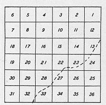
Theoretically a township is six square miles with each side one mile in length and contains 36 sections of one square mile of land. This is called a congressional township.
A civil or political township may be larger or smaller than a congressional township. Each township north of the equator is slightly smaller because the longitude lines converge meeting at the poles.
So the northern boundary of each township is shorter that the southern boundary.
Principal North-South Meridians and EastWest Baselines are used to locate townships in Illinois. The Third and Fourth Principal run north-south through Illinois and the Baselines of the Third and Fourth Principal Meridians are used to locate properties in Ogle County.
Meridian Road follows the Third Principal Meridian from Pine Rock Township in Ogle County to Rockford. Meridian Road running North and South crosses Rt. 64 six miles east of Oregon,
We have several 1872 maps of Ogle County at the Ogle County Historical Society. This is the year the Chicago and Iowa Railroad came to Oregon. This map shows townships, towns, cities and villages, land owners and the number of acres.
It contains an early history of Ogle County with illustrations of prominent buildings and a business directory for cities and villages. There was no index for this map.
Townships were arranged alphabetically by the township name. It is difficult to imagine that information and surveys for this map were obtained 33 years before the first car traveled through Oregon. Other similar Ogle Co. Maps were published in 1912 and 1930. Before 1841 Ogle County Land east of the 3rd Principal Meridian was purchased from the Federal Government Land Office in Galena. Just a reminder that you traveled to Galena by horsepower. In 1841 land west of the 3rd Principal Meridian was available. This is when the Dixon Land Office opened. This had a huge impact on future land owners in Ogle County. So in 1833 three years before Oregon was founded the Rock River Valley was surveyed into townships and eight years later in 1841 you traveled to Dixon to purchase land from the United States Land Office. 1841 is also when the first Ogle County Court House was built. Photos supplied by Otto Dick TOP LEFT: This diagram shows how sections were numbered in a township. TOP RIGHT: William Hamilton was the son
of Alexander Hamilton and was a surveyor who visited Ogle County.
Ogle County Permanent Polling Place Change due to COVID-19 Oregon-Nashua 1, 2, 3 & 5 Precincts
Precinct Old New
Oregon-Nashua 1 United Methodist Church Rock River Center
Oregon-Nashua 2 200 S. 4th St. 810 S. 10th St
Oregon-Nashua 3 Oregon, IL Oregon, IL

