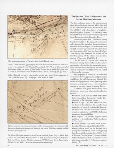
The Historic Chart Collection at the Maine Maritime Museum The chart collecrion is one of rhe many rreasures of rhe Maine Maririme Museum, which is locared on rhe banks of rhe Kennebec Rive r in Barh, "rhe Ciry of Ships" wirh a long history of shipbuilding and shipping. Berween 1748 and today, more rhan 5,000 ships have been builr and/or regisrered in rhe Barh region of rhe Kennebec River. Numbering more rhan 1,200 charts, daring back ro rhe middle of rhe eighreemh cemury, rhe collecrion provides a window rhrough which rhe maririme world of rhe pasr can be visualized and srudied. There are approximarely fifry charts from rhe 18rh cemury, 200 from rhe firsr half of rhe 19rh cenrury, and 550 from rhe second half of rhe l 9rh century. Of rhe balance from rhe 20th cemury, 170 pre-dare World War II. Like the charts of Captain Allen, many are Close-up looks at sections of Captain Allen's South A tlantic chart: rhe actual working charts used at sea. Such charts (above) Other notations appearing on the Allen charts include hurricanes and disas- customari ly belonged to rhe sea caprains rhemters, as evidenced by the note "Charles Dennis Sunk 1891. " Prior to his command of selves until rhe !are l 9rh cemury and early 20rh the Packard, A llen was master of the C harles D ennis (not a Sewall ship) from 1884 cemury, when charts wou ld be supplied as part of to 1889. As noted on the chart, the D enn is later sank in a storm offof Cape Ho rn. a ship's regular inventory. The geographical extent of the collection (below) A longside two tracks, close together but four years apart, there is a question by covers most of the shipping lanes and ports in the Capt. Allen that reads "My Last Voyage?" Allen retired in 1904. world from the mid-18th century forward. The multirude of geographical names appearing in the museum's catalogue gives one a perspecrive of rhe vastness of maritim e commerce during this era. In addition to Captain Allen's charts, some of the more noteworthy charts in rhe collecrion include: •Seventeen charts from the 1831-1836 HMS Beagle Expedition , famous for C harles D arwin's visit to the Galapagos Islands. •Mounr & Page 1750 C harr. One of the earliest charts in rhe collection, this specialry chart shows lines of magneric variarion for rhe emire Atlamic Ocean, and was first created from observations made in rhe year 1700 by the famous astronomer Edmond Halley. •Two original 1776 Atlantic Neprune charts p ublished by Joseph Frederic Wallet Des Barres (1721-1824). •William H eather's New North. Amer. & New\-%rren Lammert is a retired businessman with a strong avocation for cartography. H e fo undland Pilot, an atlas published in 1799. does research in historical maps and charts for the Maine Maritime Museum and the •Twenry charts based on the surveys made Missouri H istory Museum . during the United States South Seas Exploring Expedition, which took place from 1838 to 1842. The Maine Maritime Museum is located on the site ofthe former Percy & Small Ship•Charts of Captain James F. Murphy (1850yard on the banks of the Kennebec River in Bath, just downstream from the famous 1912) , the legendary Bath sea captain who was Bath Iron Works. (Maine Maritime Museum, 243 \-%shington Street, Bath, Maine a dominant personaliryin l 9rh cemury maririme 04530; Ph. 2 07 443-13 16; www.mainemaritimemuseum.org) history. 1, 24
SEA HISTORY 145, WINTER20 13- 14