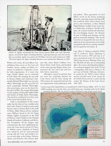
and politics. Three generations of naval officers served on the Survey, producing charts for a growing nation, learnin g skills that would do them well in future naval service, and sometimes, as Rear Admiral Hugh Rodman recalled of his Coast Survey Alaska duty, reveling in "the life in the open, the constant hazard and adventure, the ever-changing interest, the diversity of sport in fishing and shooting, and the glorious mountain climbing." Duty on the C oast Survey was good for the navy; the assignment of navy personnel to survey ships was good for the Survey; and the combination was good for our nation. J:, Charles D. Sigsbee commanded the Coast Survey Steamer Blake and, with Alexander Agassiz, invented the Sigsbee Sounding Machine, replacing hemp rope with steel wire for deep-sea sounding. Sigsbee was captain of USS Maine when she sank at Havana in 185)8. This sketch depicts the Sigbee Sounding Machine in use onboard the Albatross in 185)0. Within a few weeks, all naval officers were wi thdrawn from service on the Coast and Geodetic Survey, ending two-thirds of a century of productive cooperative service fo r both organizations. It is ironic that Capt. Charles Sigsbee was in command of USS Maine the morning she was sunk in Havana Harbor and Lieutenant Commander Richard Wainwright was executive officer. Wainwright was the so n of the US naval commander Richard Wainwright, who served many years on the Survey before the C ivil War. The yo unger Wainwright was the nephew of Alexander Dallas Bache and brother of Dallas Bache Wainwright, who served as a civilian for over forty years in the Coast and Geodetic Survey. Little is remembered of this service today, but the charts of our coastline echo their work. Names of undersea and coastal features such as Ammen Rock in the Gulf of Maine, Blal<e Plateau off our southeast coast, Pillsbury Sound in the US Virgin Islands, Sigsbee Escarpment in the Gulf of M exico, C uyler H arbor in the C hannel Islands off so uthern California, and McArthur Escarpment off the Oregon coast commemorate this early collaboratio n between the Coast Survey and the US Navy. In Alaskan waters, hundreds of features we re named by and for naval personnel serving with the Coast and Geodetic survey on such ships as the Gedney, Patterson, Hassler, and McA rthur. Port C hester, Rod-
SEA HISTORY 120, AUTUMN 2007
man Bay, Aston Island, Coffman Cove, Dewey Rocks, Fords Terror and hundreds of the names gracing Alaskan charts commemorate the navy and Coast and Geodetic Survey connection. Altho ugh it cannot be said that there was never any contention between the Coast Survey and the Navy during the 19th century, the cooperation between the two organizations transcended petty strife
Cap t. Albert E. Theberge worked for NOAA and its predecessor agency beginning in 15)69. H e retired in 15J5J5 with close to 27 years commissioned service. H e served on the N OAA ships Surveyo r, Whiting, Peirce, and Mt. Mitchell, the latter two as commanding officer. He served as chiefofgeodetic field parties working throughout most of the US and a hydrographic field party working on the west coast of Florida. Following retirement, he worked for the NOAA Central Library and has provided much of the content for the NOAA history web site, as well as having written The History of the Coast Survey
1807- 1867.
Contour map ofthe GulfofMexico as sounded by the C&GS Steamer Blake, 1873-75. Over 3, 000 soundings went into this chart, most of the deep -water soundings taken by the Sigs bee Sounding Machine. This was the first realistic bathymetric map ofany oceanic basin.
..
US COAST MD GEODETI C SIJRVE1'
Ca-411 •'. P P•11-'" A,hp t
GULF
[
or
MEXICO
NU t/<411111 . ..
.nnu a .. .. ... ,.; ... .1¥'7B"t. . "' •. •••• Ji ... -
~
...
.....
35