WRECKACIE • 1 939
RE~ORTED FLOT& AM ANO 5EABEO O B&TRUCTION&
RELATING TO THE
L0 9!il 01'" THE:
STEAMER PORTLAND ON
NC VEMBEF;i 27 ,
1 898
Ea
LO CATION OF" Llf"£ !IAVING !ITAT ION B •
~
AT·Hl!A HI HTOR ICAL L OCATIONS
&
9 EA8EO 0BBTAUCTION5
C:=J 147 . 5 HRlil
I B"l!I
!IHIP 9 TRUC::TUR £ ASHORE
I
N UM8ER OF" HOUR S ArTER THE S tNKIN D
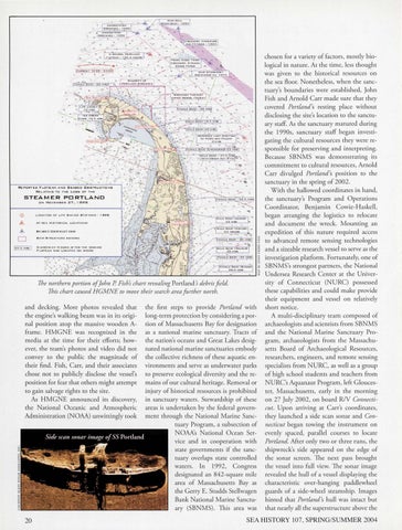
The northern portion ofJohn P Fish's chart revealing Portland 's debris field. This chart caused HGMNE to move their search area farther north.
and decking. More photos revealed rhar rhe engine's walking beam was in irs original posirion atop rhe massive wooden Aframe . HMGNE was recognized in rhe media ar rhe rime for rheir efforrs; however, rhe ream's photos and video did nor convey ro rhe public rhe magnirude of their find. Fish, Carr, and their associates chose not ro publicly disclose the vessel's position for fear that others might attempt ro gain salvage rights ro rhe site. As HMGNE announced its discovery, the Narional Oceanic and Atmospheric Adminisrration (NOAA) unwittingly rook
20
rhe first steps ro provide Portland wirh long-term protection by considering a porrion of Massachusetts Bay for designation as a narional marine sancruary. Tracrs of rhe narion's oceans and Grear Lakes designared narional marine sancruaries embody rhe collecrive richness of rhese aquaric environmenrs and serve as underwarer parks ro preserve ecological diversiry and rhe remains of our culrural herirage. Removal or injury of historical resources is prohibired in sancruary warers. Srewardship of these areas is undertaken by the federal government through the National Marine Sancruary Program, a subsection of NOAA's Narional Ocean Service and in cooperation with state governments if the sanctuary overlaps state controlled waters. In 1992, Congress designared an 842-square mile area of Massachuserrs Bay as rhe Gerry E. Srudds Srellwagen Bank Narional Marine Sancruary (SBNMS). 1his area was
chosen for a variery of factors, mosrly biological in narure. Ar rhe rime, less rhoughr was given ro rhe historical resources on rhe sea Boor. Nonetheless, when the sancruary's boundaries were established, John Fish and Arnold Carr made sure rhar rh ey covered Portland's resring place withour disclos ing rhe sire's locarion ro rhe sancruary sraff. As rhe sancruary matured during rhe 1990s, sanctuary sraff began invesrigaring rhe cultural resources rhey were responsible for preserving and inrerprering. Because SBNMS was demonsrraring irs commirmenr ro culrural resources, Arnold Carr divulged Portland 's posirion to rhe sanctuary in rhe spring of 2002. Wirh the hallowed coordinares in hand, rhe sancruary's Program and Operarions Coordinator, Benjamin Cowie-Haskell, began arranging rhe logisrics ro relocare and documenr rhe wreck. Mounring an expedition of rhis narure required access ro advanced remore sensing rechnologies and a sizeable research vessel ro serve as the invesrigarion platform. Forrunarely, one of SBNMS 's srrongesr parrners, rhe Narional Undersea Research Cenrer ar rhe Universiry of Connecticur (NURC) possessed rhese capabilities and could make provide rheir equipmenr and vessel on relarively shorr norice. A mulri-disciplinary ream composed of archaeologists and scienrisrs from SBNMS and the National Marine Sancruary Program, archaeologisrs from rhe Massachusetts Board of Archaeological Reso urces, researchers, engineers, and remore sensing specialises from NURC, as well as a gro up of high school students and reachers from NURC's Aquanaut Program , left Gloucester, Massachuserrs, early in rhe morning on 27 July 2002, on board R/V Connecticut. Upon arriving ar Carr's coordinares, rhey launched a side scan sonar and Connecticut began rowing rhe insrrumenr on evenly spaced, parallel courses ro locare Portland. Afrer only rwo or rhree runs, rhe shipwreck's side appeared on the edge of the sonar screen. The next pass brought the vessel into fu ll view. The sonar image revealed rhe hull of a vessel displaying rhe characrerisric over-hanging paddlewheel guards of a side-wheel sreamship. Images hinred rhar Portland's hull was inracr bur rhar nearly all rhe supersrructure above rhe
SEA HISTORY 107, SPRING/SUMMER 2004