Shasta Military Pass Road
Sierra Land of Ishi
LOCATION
LOCATION
Drive completely around California’s largest volcano- Mt. Shasta
Historic Native American lands and early Euro-American settlements
This loop route begins in Mt. Shasta City and follows county, state, and forest roads encircling Mt. Shasta, ending at the intersection of Interstate 5 and Highway 89.
This route starts on the southwest side of Lake Almanor at the border of the Lassen and Plumas National Forests near Highway 89.
DIFFICULTY
DIFFICULTY
You will travel on a combination of paved and dirt roads between an elevation of 3,500 and 6,800 feet. You need four-wheel drive for parts of this route. A Forest Service map, map skills, and a good sense of direction are helpful.
Expect rough road conditions and slow travel through remote country. Be prepared for downed trees or rocks on the road. A Forest Service map, map skills, and a good sense of direction are helpful.
TIME AND DISTANCE
TIME AND DISTANCE
Allow 3-4 hours to drive this route, and additional time for stopping along the way. It is approximately 75 miles.
Allow 9 hours to complete this section of the drive. It is approximately 95 miles.
THE DRIVE
The first portion of the drive, named Sierra Nevada, affords road warriors with a spectacular array of geological sites. Look for mica, quartz, and feldspar soils – remnants of granite that have succumbed to ages of weather. Look also for evidence of the vast inland sea that once weighed heavily on this part of the earth’s crust. Along this route you will have options to camp at Forest Service campgrounds, hike to the top of Humboldt Peak, and see the view from the Colby Mountain Fire Lookout. The Humbug Valley and Soda Springs were used by the Maidu Indians for ceremonial purposes. Settlers, miners, and homesteaders arrived here in the late 1840s.
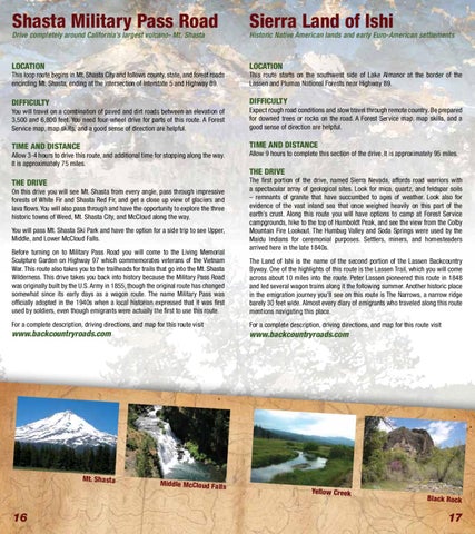
On this drive you will see Mt. Shasta from every angle, pass through impressive forests of White Fir and Shasta Red Fir, and get a close up view of glaciers and lava flows. You will also pass through and have the opportunity to explore the three historic towns of Weed, Mt. Shasta City, and McCloud along the way. You will pass Mt. Shasta Ski Park and have the option for a side trip to see Upper, Middle, and Lower McCloud Falls. Before turning on to Military Pass Road you will come to the Living Memorial Sculpture Garden on Highway 97 which commemorates veterans of the Vietnam War. This route also takes you to the trailheads for trails that go into the Mt. Shasta Wilderness. This drive takes you back into history because the Military Pass Road was originally built by the U.S. Army in 1855, though the original route has changed somewhat since its early days as a wagon route. The name Military Pass was officially adopted in the 1940s when a local historian expressed that it was first used by soldiers, even though emigrants were actually the first to use this route. For a complete description, driving directions, and map for this route visit
www.backcountryroads.com
Mt. Shasta
16
THE DRIVE
The Land of Ishi is the name of the second portion of the Lassen Backcountry Byway. One of the highlights of this route is the Lassen Trail, which you will come across about 10 miles into the route. Peter Lassen pioneered this route in 1848 and led several wagon trains along it the following summer. Another historic place in the emigration journey you’ll see on this route is The Narrows, a narrow ridge barely 30 feet wide. Almost every diary of emigrants who traveled along this route mentions navigating this place. For a complete description, driving directions, and map for this route visit
www.backcountryroads.com
Middle McCloud Falls
17