4 minute read
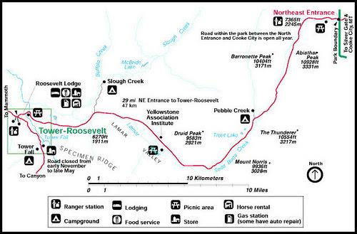
Tower-Roosevelt

from 50 Iterations
by saraholick

TOWER FALL
Advertisement
The 132-foot (40-m) drop of Tower Creek, framed by eroded volcanic pinnacles has been documented by park visitors from the earliest trips of Europeans into the Yellowstone region. Its idyllic setting has inspired numerous artists, including Thomas Moran. His painting of Tower Fall played a role in the establishment of Yellowstone National Park in 1872.
The nearby Bannock Ford on the Yellowstone River was an important travel route for early Native Americans, as well as for early European visitors and miners up to the late 19th century.

LAMAR VALLEY
Lamar Valley is an excellent place to view wildlife, with it being one of the major summer grounds for bison and elk, which attracts predators like wolves and grizzly bears.
Remember: Do not approach or encircle bears or wolves on foot within 100 yards (91 m) or other wildlife within 25 yards (23 m). Always maintain a safe distance from all wildlife. Each year, park visitors are injured by wildlife when approaching too closely.

YELLOWSTONE RIVER
Evidence of the geological forces that have shaped Yellowstone are found in abundance in this district. The hills surrounding Old Faithful and the Upper Geyser Basin are reminders of Quaternary rhyolitic lava flows. These flows, occurring long after the catastrophic eruption of 600,000 years ago, flowed across the landscape like stiff mounds of bread dough due to their high silica content.
Evidence of glacial activity is common, and it is one of the keys that allows geysers to exist. Glacier till deposits underlie the geyser basins providing storage areas for the water used in eruptions. Many landforms, such as Porcupine Hills north of Fountain Flats, are comprised of glacial gravel and are reminders that as recently as 13,000 years ago, this area was buried under ice.
Signs of the forces of erosion can be seen everywhere, from runoff channels carved across the sinter in the geyser basins to the drainage created by the Firehole River. Mountain building is evident as you drive south of Old Faithful, toward Craig Pass. Here the Rocky Mountains reach a height of 8,262 feet (2518 m), dividing the country into two distinct watersheds.

PETRIFIED TREE
Petrified Tree, located near the Lost Lake trailhead, is an excellent example of an ancient redwood, similar to many found on Specimen Ridge, that is easily accessible to park visitors. Specimen Ridge, located along the Northeast Entrance Road east of Tower Junction, contains the largest concentration of petrified trees in the world. There are also excellent samples of petrified leaf impressions, conifer needles, and microscopic pollen from numerous species no longer growing in the park. Specimen Ridge provides a superb window into the distant past when plant communities and climatic conditions were much different than today.

BANNOCK TRAIL
The Bannock Trail, once used by Native Americans to access the buffalo plains east of the park from the Snake River plains in Idaho, was extensively used from approximately 1840 to 1876. A lengthy portion of the trail extends through from the Blacktail Plateau (closely paralleling or actually covered by the existing road) to where it crosses the Yellowstone River at the Bannock Ford upstream from Tower Creek. From the river, the trail’s main fork ascends the Lamar River splitting at Soda Butte Creek. From there, one fork ascends the creek before leaving the park. Traces of the trail can still be plainly seen in various locations, particularly on the Blacktail Plateau and at the Lamar-Soda Butte confluence.

GEOLOGIC HISTORY
Absaroka volcanics, glaciation, and erosion have left features as varied as Specimen Ridge’s petrified trees to the gorges along the Yellowstone River’s Black Canyon and the Grand Canyon of the Yellowstone River.
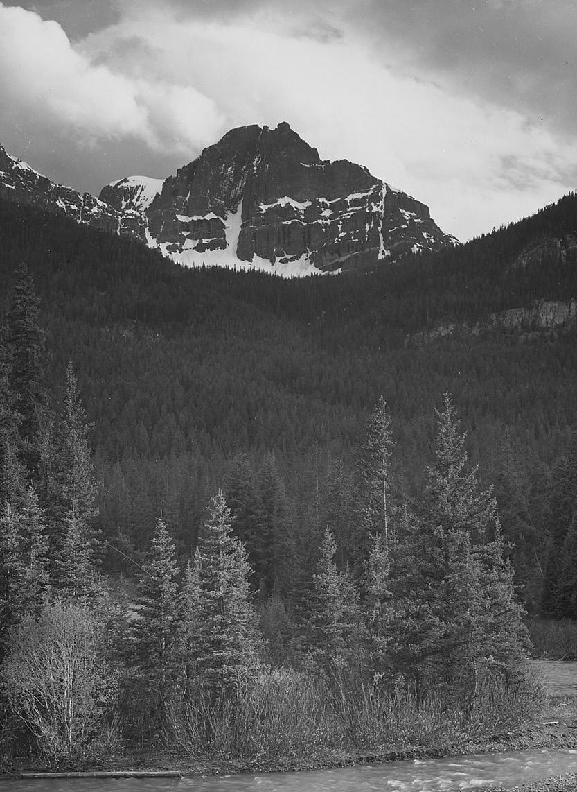
Mt. Washburn and the Absaroka Range are both remnants of ancient volcanic events that formed the highest peaks in the area. Ancient eruptions, perhaps 45–50 million years ago, buried the forests of Specimen Ridge in ash and debris flows. The columnar basalt formations near Tower Fall, the volcanic breccias of the towers themselves, and numerous igneous outcrops all reflect the volcanic history.
Later, glacial events scoured the landscape, exposing the stone forests and leaving evidence of their passage across the area. The glacial ponds and huge boulders (erratics) between the Lamar and Yellowstone rivers are remnants left by the retreating glaciers. Lateral and terminal moraines are common in these areas. Such evidence can also be found in the Hellroaring and Slough creek drainages, on Blacktail Plateau, and in the Lamar Valley.
The eroding power of running water has been at work here for many millions of years. The pinnacles of Tower Fall, the exposed rainbow colors of the Grand Canyon of the Yellowstone River at Calcite Springs, and the gorge of the Black Canyon all are due, at least in part, to the forces of running water and gravity.
In the Lamar River Canyon lie exposed outcrops of gneiss and schist which are among the oldest rocks known in Yellowstone, perhaps more than two billion years old. Little is known about their origin due to their extreme age. Through time, heat and pressure have altered these rocks from their original state, further obscuring their early history. Only in the Gallatin Range are older outcrops found within the boundaries of the park.


