1 minute read
Project Statement

from Canvey Concept

What is the reality of radical climate adaptation? On one extreme, Qatar is shipping seeds of grass into the desert from the United States to create 144 football pitches for the World Cup. (Ralston, 2022) Conversely, small island villages are turning to digital mapping to save their culture once they are buried by water due to rising sea levels. (The First Digital Nation, 2022)
How can we expect people to join the climate change team in a world where the World Cup can claim carbon neutrality and Tuvalu is trying to save its culture by digitally replicating itself in the metaverse?
Advertisement
If climate change complacency continues, the reality that our world will lose places people call “home” is inevitable. Sea levels are expected to rise by an eighth of an inch each year, and extreme weather events will become stronger and more frequent. (Newman & Qiao, 2022) “Livable” places will soon become uncomfortable for people unwilling to adapt.
As sea levels rise, cities will also increase in population. By 2050, it is expected that seven out of ten people will live in cities compared to today, with 56% living in cities. (The World Bank, 2022)
Cities will have a high demand for innovative strategies against climate change, housing costs, social equity, and more, but what happens to the places people leave behind? As cities become more populated, what if rural and suburban communities could use predicted vacant properties and sitespecific strategies to combat climate change and create a new kind of future for their communities?
This project speculates how rural and suburban communities could deconstruct themselves and use the materials to build new infrastructure that embraces high water and prepares them for smaller populations. Communities at risk could use postindustrial and remediation techniques to create livable places for the future. Their “home” may look different but will still be recognisable due to saving unique landmarks and materials.
Project Introduction
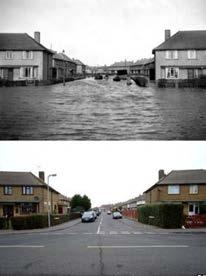
Canvey Island sits on the easternmost edge of the Thames Estuary. Most of its land mass sits at or below sea level, with one “high point” that consists of an old landfill site. The island was devastated by a surge flood in 1953, where much of the outer edge was covered by water. The island only has one way in and one way out. As people evacuated, 58 lost their lives in the rush off the island. (BBC, 2013) After the flood, measures were taken to protect the island from future surge floods by forming a concrete flood wall around the island.
Canvey faces a formidable future in a world with potentially two meters in sea level rise by 2100. (NOAA, 2022) This makes it an interesting place to set up different hypotheses on what strategies could work to prevent, slow down, or embrace high levels of water.