
1 minute read
D. PARK & RECREATION FACILITIES INVENTORY


D. PARKS & RECREATION FACILITIES INVENTORY
Developing a complete inventory of recreation facilities, programs, and events is an essential component of a five-year Recreation Master Plan, as it provides a base of information to use in developing the Action Plan. Understanding what facilities, programs and events are available to the residents of Dearborn Heights will assist in decision-making for the future. The inventory covers the following listed components: Public Parks and Facilities (city-owned) School Parks and Facilities Regional Parks and Facilities Private Parks and Recreation Facilities City Recreation Programs
Advertisement
Neighborhoods For purposes of evaluating the dispersion of park and recreation facilities throughout Dearborn Heights, parks and facilities located within the City have been assigned to one of six neighborhoods, as established in the previous Parks and Recreation Plan. The neighborhoods are defined as follows:
Neighborhood One – The northern portion of the City, generally the area north of Warren Avenue.
Neighborhood Two – North-eastern Dearborn Heights, east of Telegraph Road, south of Warren Avenue.
Neighborhood Three – Directly west of Neighborhood Two and Telegraph Road, Warren Avenue to Ford Road.
Neighborhood Four – The central portion of the City, Ford Road to the north, Dartmouth Street to the south.
Neighborhood Five – Southwest Dearborn Heights, including the narrow strip of land connecting north and south Dearborn Heights, bounded by Dartmouth Street to the north and Telegraph Road to the east.
Neighborhood Six – The southeast corner of the City, east of Telegraph Road.
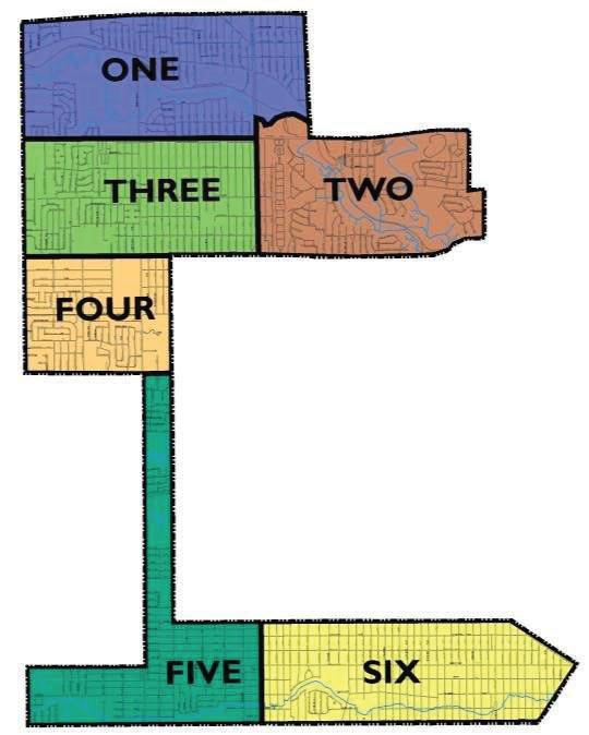
Figure 2.0: Neighborhoods

