
13 minute read
Natural Hazards


Figure 24. Income Distribution of Southington
Those living below the poverty line are the most at-risk. Unfortunately, those at risk due to income often represent additional “at-risk” categories. Examples where the low-income category often combines with other factors includes education, disability, and work status. Of the citizens living in Southington, 3.9% live in poverty, well below the state’s average of 10.0%, and even more so below the percentage of all Americans at 11.8%. Contributing to the lower poverty rates is the education level and the employment rate in the town and county. Nevertheless, the impoverished should be the focus of many of the programs and services of the fire department. These citizens benefit at greater levels from fire and fall prevention programs, emergency planning activities, supply distribution programs, and from materials targeting the risks they face routinely.
Advertisement
Natural Hazards
Although axiomatic, it is impossible to predict or prevent risks from naturally occurring hazards on a community. It is possible, however, to prepare and improve resiliency, which historically has led to improved recovery and reduced effects or impacts to the extent feasible. Preparatory examples include levee systems, elevating or burying critical infrastructure, training systems, policy reform, early warning and mass notification systems, interlocal agreements, and related efforts.
For fire departments, these preparatory efforts also include identifying, staffing, equipping, training, specializing, planning, and coordinating the emergency response system to reduce the impacts of natural hazards. The following natural hazards are considered viable threats for the Town of Southington.
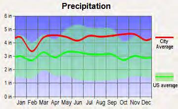
Climate is the description of the long-term pattern of weather in a specific location. Southington’s climate is widely considered comfortable for most of the year.
Figure 25. Temperature and Rainfall Totals4
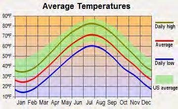
Significant weather events create disruptions to communities in many forms. Aside from a myriad of inconveniences, injuries and deaths, increased expenditures and lost revenue, infrastructure and transportation disruptions, increased demand on emergency and medical systems, and power and utility failures are commonplace in weather disaster areas. Depending on the severity and type of weather event, citizens may endure days or weeks of effects and certain losses may be permanent.
The following figure lists Federal Emergency Management Agency (FEMA) Disaster Declarations for Hartford County over the past 65 years. The town prepares for such emergencies through training and updating the Emergency Operations Plan. Statistically, the top three weather vulnerabilities for Southington are tropical hurricanes, flooding, and winter weather events. The town prepares for these types of events by maintaining generators, shelters, training levels, citizen corps, and emergency plans to work with local, state, and federal agencies to meet the residents’ needs.
4 Op. cit. City-Data
Figure 26. FEMA Disaster Declarations Hartford County
Year Weather or Event Disaster #
1955 Hurricane, Torrential Rain & Floods 42 1978 Blizzard & Snowstorm 3060 1979 Tornado & Severe Storm 608
1982 Severe Storms & Flooding 1984 Severe Storms & Flooding 1985 Hurricane Gloria
661 711 747 1991 Hurricane Bob 916 1993 Severe Winds & Blizzard, Record Snowfall 3098 1996 Blizzard of 96 1092 1999 Hurricane Floyd 1302 2003 Snow 3176 2004 Snow 3192 2005 Hurricane Katrina 3246 2005 Record Snow 3200 2005 Severe Storms & Flooding 1619 2006 Snow 3266 2007 Severe Storms & Flooding 1619 2011 Hurricane Irene 3331 2011 Severe Storm 3342
2011 Severe Storm 2012 Hurricane Sandy
4046 3353 2013 Severe Winter Storm 3361 2013 Severe Winter Storm & Snowstorm 4103 2020 COVID-19 3439 2020 Tropical Storm Isaias 3535
Reviewing the full range of natural hazards suggested under FEMA planning guidance, Southington identified several natural hazards addressed in the Emergency Operations Plan, including, in part:
Dam Failure
Dam failure can be a result of natural disasters such as structural failure due to earthquakes or overtopping due to heavy precipitation. Dams in Connecticut are regulated by the Department of Energy & Environmental Protection.
The Town of Southington owns six dams including one Class C (high hazard) and one Class B (significant hazard). All of these dams are in good condition and inspections are performed in accordance with DEEP regulations.
Drought
Drought is a prolonged period of less than normal precipitation such that the lack of water causes a serious hydrologic imbalance. The U.S. Drought Monitor (USDM) is a map that is updated each Thursday to show the location and intensity of drought across the country. The USDM uses a five-category system, labeled:
▪ Abnormally Dry or D0 (a precursor to drought, not actually drought) ▪ Moderate (D1) ▪ Severe (D2) ▪ Extreme (D3) ▪ Exceptional (D4) Drought
Drought categories show experts' assessments of conditions related to dryness and drought including observations of how much water is available in streams, lakes, and soils compared to usual for the same time of year. U.S. Drought Monitor data go back to 2000.
Figure 27. U.S. Drought Monitor Five-Category System
D0 - Abnormally Dry • Short-term dryness slowing planting, growth of crops • Some lingering water deficits • Pastures or crops not fully recovered
D1 – Moderate Drought
D2 – Severe Drought
D3 – Extreme Drought • Some damage to crops, pastures • Some water shortages developing • Voluntary water-use restrictions requested
• Crop or pasture loss likely • Water shortages common • Water restrictions imposed
• Major crop/pasture losses • Widespread water shortages or restrictions
D4 – Exceptional Drought • Exceptional and widespread crop/pasture losses • Shortages of water creating water emergencies
The U.S. Drought Monitor started in 2000. Since 2000, the longest duration of drought (D1-D4) in Connecticut lasted 46 weeks beginning on June 21, 2016 and ending on May 2, 2017. The most intense period of drought occurred the week of November 15, 2016 where D3 affected 44.5% of Connecticut land.5
5 https://www.drought.gov/drought/states/connecticut
Earthquakes
An earthquake is caused when the Earth’s crust, composed of a dozen or more rigid plates, bump against one another. Most earthquakes are the result of strain release along zones of weakness (faults) in response to the slow-motion of those crustal plates.
Damage from the impact of an earthquake can be as small as a slight shift or vibration to sustaining structural and critical infrastructure damage and/or collapse on a severe scale including damage to energy pipelines in the area. The following figure illustrates earthquakes centered in Connecticut over the past three years.
Figure 28. Connecticut-Centered Earthquakes 2017-20206

Extreme Heat
Extreme Heat is the condition whereby temperatures hover 10 degrees or more above the average high temperature in a region for an extended period. A heat wave is a prolonged period of excessive heat, often combined with excessive humidity. A heat wave combined with a drought can be a very dangerous situation.
6 https://earthquaketrack.com/p/united-states/connecticut/recent
Public health impacts during these periods include concerns of heat exhaustion or heat stroke and a higher vulnerability to wildfire. Individuals, especially the elderly, who live in residences without airconditioning or if there are electrical service blackouts, are more susceptible to heat-related emergencies. Local water supply distribution from natural sources can be severely compromised reducing water supply for firefighting purposes.
Floods
Floods are one of the costliest natural hazards in the world, yet most flood loss is both predictable and preventable. Floods are an accumulation of water within a body of water, which results in the overflow of excess water onto adjacent lands, usually floodplains. Most floods fall into the following three categories: riverine flooding, coastal flooding, and shallow flooding. Because Southington is relatively flat in most of the town, flood waters recede slowly once the waters accumulate.
Figure 29. Flood Hazard Zone Map7
The majority of the Town drains to the Quinnipiac River (a tributary to Long Island Sound), although the eastern edge of town drains to the Mattabesset River in Berlin. Aside from the Quinnipiac River, other major streams in Southington include Cussgutter Brook, Eightmile River, Roaring Brook, Hamlin Brook, and Misery Brook.

7 https://msc.fema.gov/portal/search#searchresultsanchor
Landslides
A landslide is defined as the movement of a mass of rock, debris, or earth down a slope. Landslides are a type of "mass wasting," which denotes any down-slope movement of soil and rock under the direct influence of gravity. The term "landslide" encompasses five modes of slope movement: falls, topples, slides, spreads, and flows. These are further subdivided by the type of geologic material (bedrock, debris, or earth). Debris flows (commonly referred to as mudflows or mudslides) and rock falls are examples of common landslide types.
Almost every landslide has multiple causes. Slope movement occurs when forces acting downslope (mainly due to gravity) exceed the strength of the earth materials that compose the slope . Causes include factors that increase the effects of down-slope forces and factors that contribute to low or reduced strength. Landslides can be initiated in slopes already on the verge of movement by rainfall, snowmelt, changes in water level, stream erosion, changes in ground water, earthquakes, volcanic activity, disturbance by human activities, or any combination of these factors. Earthquake shaking and other factors can also induce landslides underwater. These landslides are called submarine landslides. Submarine landslides sometimes cause tsunamis that damage coastal areas.
8
Terrain and Waterways
Southington rests in a valley between two mountains on its east and west sides. The terrain is relatively flat between the two mountains and sits approximately 154 feet above sea level. The town has developed sophisticated water and road distribution systems that provide for public safety and quality of life. One of the benefits of these development accomplishments is the assurance the citizens have that the service providers have access to most, if not all the areas where they reside.
The Quinnipiac, Eight Mile, and Ten Mile Rivers flow through the Town of Southington, providing for a picturesque feature, with myriad recreational opportunities within the community. From fishing and canoeing, to hiking and camping, these rivers provide an abundance of opportunities for the residents and visitors to Southington. These rivers provide the fire department with opportunities to offer public education materials to reduce the associated risks of navigable waterways.
8 https://www.usgs.gov/
Tornados and High Winds
Tornados are a violent rotating column of air that has contact with the ground and is often visible as a funnel cloud. Its vortex rotates cyclonically with wind speeds ranging from as low as 40 mph to as high as 300 mph. Classified by the Enhanced Fujita Scale (EF-Scale 2007), tornados are categorized by a numeric score of zero to five based on observed damage severity.
Figure 30. Enhanced Fujita Scale (EF-Scale 2007)
Designation
EF-0
Wind Speed (mph)
65–85
EF-1 86–110
EF-2 111–135
EF-3 136–165
EF-4 166–200
EF-5 > 200
Typical Damage
Minor or no damage. Peels surface off some roofs; some damage to gutters or siding; branches broken off trees; shallow-rooted trees pushed over. Confirmed tornadoes with no reported damage (i.e., those that remain in open fields) are always rated EF-0. Moderate damage. Roofs severely stripped; mobile homes overturned or badly damaged; loss of exterior doors; windows and other glass broken. Considerable damage. Roofs torn off well-constructed houses; foundations of frame homes shifted; mobile homes destroyed; large trees snapped or uprooted; light-object missiles generated; cars lifted off ground. Severe damage. Entire stories of well-constructed houses destroyed; severe damage to large buildings such as shopping malls; trains overturned; trees debarked; heavy cars lifted off the ground and thrown; structures with weak foundations are badly damaged. Devastating damage. Well-constructed and whole frame houses completely leveled; cars and other large objects thrown, and small missiles generated. Extreme damage. Strong-framed, well-built houses leveled off foundations are swept away; steel-reinforced concrete structures are critically damaged; tall buildings collapse or have severe structural deformations; some cars, trucks, and train cars can be thrown approximately 1 mile (1.6 km).
Tropical Cyclones and Hurricanes
Tropical Cyclones and Hurricanes are an intense tropical weather system of strong thunderstorms with a well‐defined surface circulation and maximum sustained winds of 74 mph or higher. Tropical storms are extremely low-pressure areas over the ocean with a cyclonic rotation of winds. They can be considered very strong thunderstorms. The tropical storms are named so because they usually develop in the tropics. A tropical storm is classified according to its speed. When the speed of the wind is between 39 mph to 73 mph, the tropical depression developed is classified as a tropical storm. Those storms that form in the middle latitudes are often called Extratropical Storms.
Scale
Category 1
Category 2
Category 3 (Major)
Category 4 (Major)
Category 5 (Major)
Figure 31. Saffir-Simpson Hurricane Damage Scale
Wind Estimate
74-95 Typical Damage
Very dangerous winds will produce some damage: Well-constructed frame homes could have damage to roof, shingles, siding and gutters. Large branches of trees will snap, and shallowly rooted trees may be toppled. Extensive damage to power lines and poles likely will result in power outages that could last several days.
96-110
Extremely dangerous winds will cause extensive damage: Well-constructed frame homes could sustain major roof and siding damage. Many shallowly rooted trees will be snapped or uprooted and obstruct roadways. Neartotal power loss to impacted area.
111-129
130-156
157 or Higher
Devastating damage will occur: Well-built framed homes may incur major damage or removal of roof decking and gable ends. Many trees will be snapped or uprooted, blocking numerous roads. Electricity and water will be unavailable for several days to weeks after the storm passes. Catastrophic damage will occur: Well-built framed homes can sustain severe damage with loss of most of the roof structure and/or some exterior walls. Most trees will be snapped or uprooted, and power poles downed. Fallen trees and power poles will isolate residential areas. Power outages will last weeks to possibly months. Most of the area will be uninhabitable for weeks or months. Catastrophic damage will occur: A high percentage of framed homes will be destroyed, with total roof failure and wall collapse. Fallen trees and power poles will isolate residential areas. Power outages will last for weeks to possibly months. Most of the area will be uninhabitable for weeks or months.
Since the mid-1950s, Southington and Hartford County have received the effects of several hurricane and tropical cyclone events, including the federal disaster declarations identified in the following figure.
Figure 32. FEMA Hurricane-Related Disaster Declarations Hartford County
Year Hurricane-Related Event Disaster #
1955 1985 1991 1999 2005 2011
2012
2020 Hurricane, Torrential Rain & Floods Hurricane Gloria Hurricane Bob Hurricane Floyd Hurricane Katrina Hurricane Irene Hurricane Sandy Tropical Storm Isaias
42 747 916 1302 3246 3331 3353 3535
Wildfires
Wildfires are large, destructive fires that spreads quickly over woodland, grass, and brush. Recently, they have become a serious and growing hazard over much of the western United States. Although fires in undeveloped areas are healthy for trees and grasses, wildfires pose threats to both life and property where humans have developed. Beneficial fires and threatening wildland fires meet at an area known as the urban-wildland interface area.
Wildland-urban interface is the contact zone between undeveloped forested areas and urban areas. This transitional environment is most susceptible to fire. As people and wildlands come into contact, conflict arises from the threat of wildfire or from emergency services inadequate to protect rural populations.
Connecticut traditionally experiences high forest fire danger in the Spring from mid-March through May. Department of Energy and Environmental Protection (DEEP) Division of Forestry monitors the danger of forest fire to help protect Connecticut's 1.8 million acres of forested land. DEEP distributes daily advisories identifying the fire danger level in Connecticut, which is especially important in the Spring, which is the height of the elevated threat for forest fires in Connecticut. Forest fire danger levels are classified at low, moderate, high, very high or extreme. In an average year approximately 500 acres of Connecticut woodland are burned by forest fires.
Winter Storms
Winter Storms include snow, sleet, freezing rain, or a mix of these wintry forms of precipitation, including blizzards, the most dangerous of all winter storms, and ice storms that down trees, cause widespread power outages, damage property, and cause fatalities and injuries to human life. A Nor’easter is the biggest threat for winter weather, usually from November through April, causing significant snowstorms and mixed frozen precipitation. Strong winds are produced that cause coastal flooding and erosion.
The impacts of winter storms are primarily measured in financial costs associated with management and recovery from the disaster. House fires and carbon monoxide poisoning pose higher risks as people use supplemental heating devices to combat the cold temperatures. Power outages and downed trees have a significant impact on residents.


