6 minute read
Public Perceptions


2
PUBLIC INVOLVEMENT
Advertisement
suggestions and ideas.
PUBLIC PERCEPTIONS
Together, the three outreach strategies provided a unique interpretation of the City’s transportation network, the desired future amenities and the characteristics that Franklin residents associate with the city itself. The residents of Franklin agree that the current street network does not meet the existing or future transportation demands of the city. Many of the concerns, which were brought-up by the residents on the MySidewalk site, had to deal with current congestion problems seen on many of the main thoroughfares. Many residents believe that these congestion problems exist as a result of the infrastructure in Franklin failing to grow as quickly as new development. Along with these areas of congestion, residents expressed concern about limited connectivity between neighborhoods and local areas of interest. Many neighborhood streets do not provide adequate connectivity, and many neighborhoods have a singular entry/exit road for the entire development. Along with connectivity at a neighborhood level, the residents were able to identify areas of opportunity for new road infrastructure, new traffic signals, additional turn lanes and road widening projects. To further promote the exceptional quality of life that currently exists in the City of Franklin, many residents are in favor of building and further developing bicycle and pedestrian infrastructure. The residents of Franklin are aware of the positive effects that come from investing in alternative modes of transportation in their community. Although a large portion of Franklin’s residents are advocates for bicycle infrastructure, the general consensus among residents is that the existing congestion problems on the main thoroughfares need to have a higher priority than new bike infrastructure. Residents also stated that they did not want to implement bicycle infrastructure that would further increase congestion on roads by removing needed vehicular lanes. Many residents have also expressed their desire to have recreational trails that connect neighborhoods and major economic, cultural, and political nodes throughout the city. When
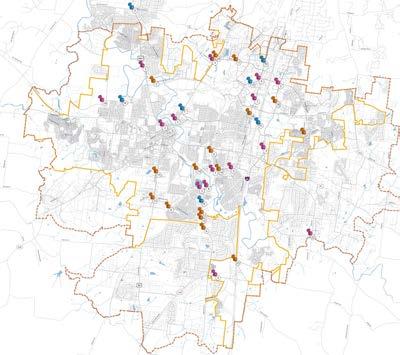
MAP LEGEND
INFRASTRUCTURE OPPORTUNITIES
Infrastructure opportunities include those suggestions that would require additional built infrastructure or physical changes to the transportation network.
These opportunities could include new roadways, road widening, additional or new turning lanes or traf c lights.
AREAS OF CONGESTION
Area of congestion include those suggestions that document traf c concerns related to traf c amounts or travel time. These points could also include general information on safety and perceived level of service concerns.
BICYCLE AND PEDESTRIAN OPPORTUNITIES
Bicycle and pedestrian opportunities include those suggestions that would improve the experience of pedestrians and cyclists throughout the study area.
These opportunities could include new sidewalks, bicycle lanes and proposed multi-use trail connections.
These points could also include general information on bicycle and pedestrian safety concerns.
GENERAL INFORMATION
The information provided on this map is a summary of previous stakeholder interviews, staff discussions and community input via the project’s MindMixer site. The MindMixer site allowed participants to map the speci c area of concern and document an infrastructure idea.
The complete list of ideas and comments can be found at connectfranklin.mindmixer.com
For the purposes of this board comments and areas of concern were consolidated when possible.
N
Mac
MAP LEGEND
1
2
3
4
5
6
7
8
9
Add sidewalks from The Factory to 1st Avenue to keep people from walking in road. Westhaven is going to have over 2,000 homes when completed. Mack Hatcher Parkway needs to be four lanes and it needs to get started. Bridge Street, Hillsboro Rd, Main St, Lewisburg Pike at Mack Hatcher Parkway,Royal Oaks Blvd, Franklin Rd at Mallory Station Rd, Goose Creek Bypass and Carothers are all serious congestion areas if hit at the wrong time of day. And of course, most of Cool Springs as well. I would never feel safe walking virtually anywhere on Lewisburg Pike or Del Rio Pike. I've come upon cyclists on Lewisburg Pike and Del Rio Pike, and it's incredibly dangerous for both the cyclist as well as the cars trying to get around the cyclist taking up the entire lane, as both of those roads have many curves and hills. You just take a chance to go around hoping there is no oncoming traf c because Joe Cyclist apparently owns the road and doesn't care to hold up you or 20 other cars behind you. There is no sidewalk in many places on Franklin Rd either. Finish the sidewalks up Hillsboro Road to Berrys Chapel Road (and as far north as possible - to Old Hickory Blvd would be great!) Mack Hatcher Parkway needs 4 lanes from Highway 96 (Murfreesboro Road) to Columbia Avenue. In the evening South Royal Oaks traf c trying to turn left at Mack Hatcher Parkway will regularly back up to the post of ce.
Sometimes the last 2 miles of my commute home between the Interstate at 96 and Hunters Chase can take 30 minutes. Congestion spots include Cool Springs and Mallory Lane
10 Bicycle lanes should be added to Mallory Lane which could be done in existing space (grass areas), speed limits need to be lowered, and more pedestrian crossings (sidewalks in the median) should be added. 11 Currently, there are no bike lanes heading North/South between Mallory and Liberty. Instead of contructing an expensive greenway from scratch, the City could pave a short section between Huf nes Ridge Rd. and McEwen as a multi/use path. 12 Add a light on Lewisburg Avenue to slow traf c down so its not a stand still once you get closer to Mack Hatcher Parkway.
13
14
15
16
Lewisburg Avenue need to be widened to accommodate all the cars and to time the lights more appropriately. A sidewalk is needed for safety on Lewisburg from Heath Place/Eastern Flank Battle eld Park/Carnton Plantation to downtown Franklin. Tourists and resident have no choice but to walk on a road without a shoulder or in uneven weeds off the road. Columbiua Avenue between Downs Boulevard and Mack Hatcher Parkway needs to be widened now and before anymore development is added. Two left turn lanes are needed on S Royal Oaks Boulevard turning onto a four Lane Mack Hatcher Parkway.
17
Add and additional west bound lane along Mallory Station Road. Also provide a longer left turn light during PM rush hour.
18
Change travel direction for portions of roadway during peak traf c times. Use Carothers Parkway and Royal Oaks Boulevard/ Mallory Lane as one way pairs during peak traf c time. 19 Del Rio Pike can't handle increased traf c coming from the school.
20 Right turn lane needed at Mallory Station Road and Franklin Road intersection. 21 Roundabout at Liberty Pike and Oxford Glen Drive is too small.
22 S. Carothers Road is used as a short cut.
23 Potential roadway connections with interstate overpass.
i
transportation systems: targeted improvements and areas of concern

A summary of comments gathered to date was presented at the Community Workshop with the opportunity for additional input.
this bicycle and pedestrian infrastructure is developed, residents have advocated that safety and aesthetic factors be considered to ensure a safe and beautiful bicycle and pedestrian system. The residents of Franklin, when surveyed, had some great ideas for viable mass transit in their community. Along with bicycle and pedestrian infrastructure improvements, there is still room for more transit options to further alleviate congestion on the roads and to give residents an alternative mode of transportation. Several residents suggested that the City utilize and further expand on the existing regional transit system. A number of residents voiced their skepticism about a large scale transit system being implemented in their community. To counter their skepticism, many residents suggested alternatives to a larger transit system. Most of these alternatives were various shuttle bus routes that


