THE CAPITAL LINE & CULTURAL PARK CONCEPT DESIGN


DOWNTOWN COLUMBUS STRATEGIC PLAN Prepared For: Prepared By: Downtown Columbus Inc. REALM Collaborative EMH&T
PACKAGE April 5, 2024
RECOMMENDATION
CLIENT TEAM

Jeff Edwards Board Member
Greg Davies CEO
Amy Taylor President
Madison Cole Director of Communications
PROJECT TEAM
Brian Bernstein Co-Founder
Carmine Russo Jr. Co-Founder
Zach Sevenish Designer
Marissa Kirkendall Designer
Rachel Sheets Co-Op

Robert Ferguson Senior Project Manager, Principal
Craig Schrader Structures Team Leader
Bob Weger Project Engineer
INTRODUCTION THE CULTURAL PARK
EXECUTIVE SUMMARY BRIDGES AS PLACES 04 24 08 28 THE CAPITAL LINE RIVERFRONT MICRO-ZONES 58 96 ANALYSIS & EXISTING CONDITIONS CONCEPTS WEDGE AND BRIDGE STRUCTURAL & COST ANALYSIS CONTENTS EMERGING THEMES CONCEPT PLAN COLUMBUS’ CULTURAL DIVERSITY PROGRAM TYPOLOGIES 36 38 40 52 84 MODERN CITY HALLS 50 STRATEGIES TO CONNECT 26 10 CHALLENGES & OPPORTUNITIES
APPENDIX
THE SCIOTO RIVERFRONT STUDY
Activating the Riverfront
A deeper analysis of contemporary riverfronts across the country revealed a number of ideas on amenities and programmed public spaces that add to the vitality of a downtown core. From the east to west coasts, we see many common themes emerging that will be outlined in this document. The evolution of our waterways as a utilitarian edge of the city, to an active place for people has been underway for decades in some of our largest cities. For Columbus, recent investments in the Scioto Greenways have added acres of new parklands that have laid the groundwork for a new phase of public realm improvements that can enhance the downtown core as a regional destination.

2
CONCEPT 2
Creating a highly activated waterfront destination while also strengthening the connection to The Peninsula.

1CORE PROJECT 1
3
CONCEPT 3

Creating a Gateway Plaza & Crossblock Pedestrian Alley.

Transforming Gay Street and adjacent alleys into the 'Living Room' of the neighborhood.
4
CONCEPT 4
Creating The Capital Line, an iconic 2-mile pedestrian loop that connects districts and cultural attractions.
DOWNTOWN COLUMBUS | THE CAPITAL LINE & CULTURAL PARK 4
INTRODUCTION
PROJECT SCHEDULE
The Process
As an extension of the Downtown Strategic Plan Gay Street Public Realm Pilot Neighborhood Study, REALM was engaged by the Downtown Columbus Inc. (CDI) to further expand on the activation of the Scioto riverfront at the terminus of Gay Street adjacent to City Hall. This study would explore the extension of the Gay Street “Living Room” concept and consider the feasibility of the Capital Line passage utilizing Broad Street bridge to connect the core of downtown to the Peninsula redevelopment project. The study team kicked off with a trip in early September 2023 to New York City to observe the convergence of the city’s urban edges and how they transition to waterfront spaces with an activated public realm. Green infrastructure and amenity zones provide much needed open space and recreational opportunities for adjacent residents. These design concepts and physical space connections helped to guide the initial programming studies for the river’s edge and provide creative solutions for connecting the city through public infrastructure.
September 2023
October 2023 - January 2024
Part 1 - Site Analysis
October 12th, 2023
Client Team Meeting #2
- Site Inventory & Analysis
- Riverfront Concepts
- Programming Analysis
- Bridge Concepts
- Conceptual Approach
Part 1 - Site Analysis
September 27th, 2023
Client Team Meeting #1
- NYC Trip Debrief
- Covenant Understanding
- Base Maps & Previous Plans
- Precedent Studies: Riverfronts / Bridges
- Scale Studies / Test Fits
Part 2 - Concept Design
November 13th, 2023
Client Team Meeting #3
- Bridge Feasibility w/ EMH&T
- Identifying Key Programs / Conceptual Advancement
- Client Feedback
Part 2 - Concept Design
December 14th, 2023
Client Team Meeting #4
- Preferred Concept Identified
- Solidifying Programs
- Bridge Feasibility Studies
- NYC Team Regroup (Select Meetings)
March 2024
April 2024+
Part 2 - Recommendations
January 24th, 2024
Client Team Meeting #5
- Connect Downtown to the Peninsula
- Activate the Riverfront (Strategic Plan)
- Utilize the Broad Street Bridge to Connect
- Cost Analysis & Timeline Estimate
(Programmatic Amenities, Feasibility & Strategies) Final Recommendations Delivered Next Steps...
NYC Curiosity Trip Site Analysis (Inventory, Opportunities & Constraints) Concept Design
DOWNTOWN COLUMBUS | THE CAPITAL LINE & CULTURAL PARK 5
The Riverfront will Connect the Downtown Core to New Development Opportunities on the Peninsula and West to Franklinton
For decades the center of urban life in downtown Columbus has been at the corner of High Street and Broad Street. Planners of the Ohio Statehouse recognized the importance of the high ground on the eastern banks of the Scioto. Over time with the development of the Franklinton flood wall (2004), the western banks of the river have been unlocked for new investment opportunities. This is a time to redefine the limits of an urban core that is centered around the Scioto Greenways; acres of new open, publicly accessible green spaces that will help to create identity for the future inhabitants of the city.


Stitching the City
CONNECT & ACTIVATE FROM EAST TO WEST
In the development of a “Central Park” for the city, where the Capital Line meets the park, there are two distinct connectors at Broad Street and Rich Street. These to points are where the river meets the city and present opportunities for transition from the eastern core of the city to the renewed Peninsula and Franklinton as they continue to grow and add residents.
DOWNTOWN COLUMBUS | THE CAPITAL LINE & CULTURAL PARK 6 THE OPPORTUNITY RE-CENTERING DOWNTOWN
FRANKLINTON CONNECTOR COSI GAY STREET BROAD STREET BRIDGE NATIONWIDE ARENA HUNTINGTON PARK COLUMBUS CONVENTION CENTER RICH STREET CITY HALL OHIO STATEHOUSE COLUMBUS COMMONS VETERANS MEMORIAL & MUSEUM DORRIAN GREEN THE PENINSULA 4TH STREET BICENTENNIAL PARK GERMAN VILLAGE CONNECTOR KING-LINCOLN BRONZEVILLE CONNECTOR SHORT NORTH CONNECTOR ARENADISTRICTCONNECTOR
Stitching


THE CAPITAL LINE
As in many downtowns that are stitching new development projects together after years of neglect, there are voids that prevent the fabric of connectivity in the short-term. The Capital Line is the opportunity to invest in a long-term urban infrastructure solution that will help to connect current investments to future development opportunities through enhancements to the public realm.
THE CULTURAL PARK
In the 21st century, cities are defined by their public spaces, and there is no better place to create identity for Columbus than the crossroads of the new Capital Line, City Hall and the Broad Street bridge. This programmable public space will help to pull pedestrians through a series of activated park spaces that will better connect investments being made downtown to the Peninsula.
THE BROAD STREET BRIDGE
Re-imagining the Broad Street bridge as a place for people, not just cars, is a key strategic objective of this study. In lieu of creating more infrastructure with a new stand-alone pedestrian bridge, a core premise of this study was to utilize existing infrastructure to better connect the eastern and western banks of the Scioto to create a more vibrant downtown experience.
DOWNTOWN COLUMBUS | THE CAPITAL LINE & CULTURAL PARK 7 URBAN FRAMEWORK PLAN 03.01.2023 CULTURAL LOOP CONCEPT CULTURAL LOOP CONCEPT 4TH & MAIN DISTRICT EDWARDS DEVELOPMENTS CAPITAL SQUARE THE PENINSULA RIVER SOUTH RIVER NORTH ARTS & CULTURE DISTRICT NATIONWIDE A KEY TENANT OF THE 2022 DOWNTOWN STRATEGIC PLAN IS TO CREATE TAPESTRY OF NEIGHBORHOODS. THE LOOP AS PROPOSED ALREADY STARTS TO CONNECT EXISTING ‘DISTRICTS’ AND COULD HELP TO BOLSTER EMERGING ONES SUCH AS THE EDWARDS DEVELOPMENTS ALONG 4TH STREET CONNECTING DISTRICTS
the City CONNECT & ACTIVATE FROM EAST TO WEST
SEPTEMBER 5-6, 2023
To Inspire and Guide the Strategic Planning Efforts for the Scioto Riverfront
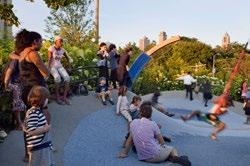
Purpose: To experience and catalog ideas for the public realm connected to and along New York City’s waterways for inspiration and guidance as the Downtown Columbus Inc. (CDI) advances its strategic planning efforts for activation at the Scioto Riverfront.
Project Exploration:
Hudson River Park Pier 40-45
Gansevoort Peninsula
Little Island
Hudson River Park
High Line
9th Avenue Open Street
Hudson River Park Pier 25-26
Teardrop Park
Rockefeller Park
Battery Park City Esplanade
Financial District, Stone Street and Water Street
South Street Seaport Piers 15-17
East River Waterfront Esplanade
Brooklyn Bridge Park


DOWNTOWN COLUMBUS | THE CAPITAL LINE & CULTURAL PARK 8 NYC CURIOSITY TRIP
COMMUNITY GARDENS
ELEVATED DECKS / SEATING
ACTIVE URBAN PLAZA
ART / SCULPTURE PIECES
PERCH / OVERLOOK
KEY FINDINGS & TAKEAWAYS
PROGRAMS AND ATTRACTIONS
FOOD / BEV KIOSKS
REC & EQUIPMENT RENTALS PLAZA / FOOD TRUCKS
URBAN BEACH (SAND, BOULDERS)
OPEN FIELD & LAWN
BOARD WALKS (WOOD / CONCRETE) GARDENS / WATER FEATURES
BOARD WALK / DOCKS
PERGOLA / SHADE STRUCTURES
BIG SHADE TREES
GLASS RETAIL CONNECTOR
PROMENADE WITH LINED BENCHES
TREE GROVES
NATURAL WATER’S EDGE PLANTINGS
CHILDREN PLAY AREAS
A Dynamic Waterfront in a Growing City and Vibrant Region
New York is the most dense city in the country and presents good lessons on the continued transition from offices to residential communities in urban space. As industrial waterfront space shifts from concrete and shipping piers to green space and recreational fields, its important to consider the diversity of amenities offered.
Both active and passive spaces provide opportunities for different users of any age and ability to have a place to escape and seek much valued connections to nature. In doing so, there is the ability to help create identity and help define the city in a new way that will establish an approach to future interactions with our natural resources with broader connections to regional trail systems.
The 2022 Downtown Strategic Plan establishes a compelling, collective vision for Downtown over the next 10 years. It identifies desired investments, policy changes, and improvements to enhance the vitality of Downtown. The future activation of the Scioto river is a priority as more residents begin to inhabit downtown. Providing comfortable places for people to use for respite, recreation and social gathering should be carefully studied and planned for.

DOWNTOWN COLUMBUS | THE CAPITAL LINE & CULTURAL PARK 9
The 2022 Downtown Strategic Plan Aims to Better Connect and Activate the Riverfront
The Peninsula (West Side): Recent developments occurring both in East Franklinton and the Peninsula have shifted the balance of downtown residents to surround the public space asset of the Scioto Greenways, a 30+ acre park space that has the ability to become the center of urban life in the heart of the city. In addition to further activations along the riverfront’s east side, the west side should consider opportunities to activate COSI and the green spaces there to further enhance the experience for the increasing residential population in the city.
Broad Street Bridge: This study will further examine the opportunities to better connect both the east and west anchors of downtown utilizing the existing Broad Street Bridge structure. Currently the bridge is leveraged for vehicular movement, with a less than desirable experience for pedestrians. Ideas will focus on the ability to prioritze pedestrian movement, extend the Capital Line shared use path extending from Gay Street, and add additional landscape features to create a comfortable connection for people.
Downtown (East Side): With renewed investment at the corner of High Street and Gay Street there is opportunity to extend this energy from the core of downtown, through the civic campus, past City Hall all the way to the Scioto River. The 2022 Downtown Strategic Plan calls for new activation at the waterfront in this location. This study will further examine the opportunity for this space, as the pedestrian nature of the transformed Gay Street corridor begins to prioritize pedestrians and cyclists as they traverse this public space.

DEVELOPMENT
A newly released vision to transform Gay Street into a pedestrian friendly shared street and the construction / conversion of residential units in the Downtown Core will help extend activity past typical business hours.
DISCONNECTED
Currently, the Scioto River acts as a barrier between the new investments occurring on the East and West. The Broad Street bridge serves as the only direct connection between these areas and unfortunately provides a harsh pedestrian experience.
DEVELOPMENT
New investments on the Peninsula and East Franklinton provide an opportunity to bring energy and people closer to the Downtown Core and spur more activity.
N 400’ DOWNTOWN COLUMBUS | THE CAPITAL LINE & CULTURAL PARK 10 EXISTING CONDITIONS EAST / WEST DISCONNECTED

WEST SIDE — INVESTMENTS

NORTH / SOUTH TRAIL SYSTEM


EAST SIDE — INVESTMENTS
DOWNTOWN COLUMBUS | THE CAPITAL LINE & CULTURAL PARK 11
THE CAPITAL LINE
THE PENINSULA
CURRENT — ECHELMAN SCULPTURE
GRAVITY
SCIOTO GREENWAYS
Redevelopment at the Riverfront Requires Careful Planning and Consideration
With many land-use restrictions, the future development at the waterfront presents a series of challenges that will need to be overcome with any new design solution. An environmental covenant restricts much of the hydrological edges to naturalized landscape plant communities that could be further enhanced with supplemental vegetation and amenity spaces. These requirements protect the Scioto River and surrounding areas from further contamination or destruction and should be respected.
Traversing from the water’s edge to the urban edges of the city presents tremendous opportunity to propose a connection of terraced urban landscape experiences that will enhance the parklike quality of the Greenways that have already been established. It is imperative that floodway paths and hydrological flows be minimally impacted with any proposed use that will occur in these zones.

ENVIRONMENTAL COVENANT
Due to many restrictions a clear plan would be needed to create more activation along the Scioto riverfront.
BROAD STREET STATE STREET GAY STREET RUSH ALLEY STATE STREET CHAPEL STREET MARCONI BOULEVARD FRONT STREET BELLE STREET STARLING STREET LONG STREET SPRING STREET C I V I C C E N T E R D R I V E WASH I NG T O N B O U L E V A R D S C I O T O R I V E R N 400’ DOWNTOWN COLUMBUS | THE CAPITAL LINE & CULTURAL PARK 12
EXISTING CONDITIONS RIVERFRONT RESTRICTIONS

STREET DOWNTOWN COLUMBUS | THE CAPITAL LINE & CULTURAL PARK 13
OHIO EPA — MAINTAIN NATURAL CONDITIONS METRO PARK — PARK USE ONLY FEMA FLOODWAY — KEEP FREE OF ENCROACHMENT
The City and its Relationship to the Waterfront is Complex
In consideration of the hydrological flow of the river and its relationship to the fluctuating banks, the landscape and topographic appearance must function to serve as a living water’s edge. In doing so, a variety of landscape experiences can be interwoven to provide places for people to engage with the water without impacting the critical infrastructure that has allowed for continued investments to grow in the core of downtown.
The careful consideration of the grading as the city meets the river can provide for dramatic impact zones that can appeal to residents and visitors as attractions to downtown. The breakdown of the green space into topographic modeled zones will help the future planning of spatial typologies that will be permitted in particular areas that lend itself to programming and amenities with limited impacts to costly infrastructural components.
COMPLEX TOPOGRAPHY
Much of the existing riverfront is above a 10% slope which presents multiple challenges for recreation and programming.
MINIMAL SLOPE
Areas with an existing minimal slope could be taken advantage of to provide programming / recreation in the short-term.

BROAD STREET STATE STREET GAY STREET RUSH ALLEY STATE STREET CHAPEL STREET MARCONI BOULEVARD FRONT STREET BELLE STREET STARLING STREET LONG STREET SPRING STREET C I V I C C E N T E R D R I V E WASH I NG T O N B O U L E V A R D S C I O T O R I V E R 3-10% Slope < 15% Slope > 3% Slope 10-15% Slope LEGEND DOWNTOWN COLUMBUS | THE CAPITAL LINE & CULTURAL PARK 14 EXISTING
TOPOGRAPHY
CONDITIONS
1 3 2


STREET DOWNTOWN COLUMBUS | THE CAPITAL LINE & CULTURAL PARK 15 3% - 10% SLOPE
- 15% SLOPE > 15% SLOPE 1 2 3
10%
Downtown Can Benefit From Adding More Pedestrian Scaled Public Spaces
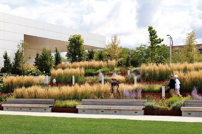
In Downtown Columbus, the Scioto Greenways have added a significant amount of new publicly accessible green space along the riverfront, particularly at the terminus of Gay Street. With approximately 30+ new acres of park land, much of it is monolithic in appearance and offers mostly passive recreational opportunities. Activities such as sitting, strolling and relaxing outdoors currently dominate the primary uses of this space.
It is critical to address the functionality of these green spaces to offer new amenities and experiences. These spaces often serve as visual attractions rather than functional ones making it essential to provide urban residents with a variety of more accessible spaces where people can gather, walk their dogs and enjoy connections to nature while benefiting from appropriately scaled spaces. This approach aligns with lifestyle offerings seen in other urban centers across the country, as well as in many suburban town centers. It not only enhances the livability of our city, but also promotes a healthier and more vibrant urban experience.
HIGH MAINTENANCE
Large lawn areas require a high maintenance routine and do not provide a dynamic landscape experience.
NATURALIZED EDGE
The naturalized edge helps protect the waters edge, but acts as a visual barrier for pedestrians trying to interact with the river.
BROAD STREET STATE STREET GAY STREET RUSH ALLEY STATE STREET CHAPEL STREET MARCONI BOULEVARD FRONT STREET BELLE STREET STARLING STREET LONG STREET SPRING STREET C I V I C C E N T E R D R I V E WASH I NG T O N B O U L E V A R D S C I O T O R I V E R N 400’ DOWNTOWN COLUMBUS | THE CAPITAL LINE & CULTURAL PARK 16
GREEN SPACE
EXISTING CONDITIONS
1 2 3


STREET DOWNTOWN COLUMBUS | THE CAPITAL LINE & CULTURAL PARK 17
UPPER LAYER — PLANTED AREAS
MIDDLE LAYER — MOWED LAWN
1 2 3
LOWER LAYER — NATURALIZED EDGE
Broad Street Can Be Reimagined as a Pedestrian Friendly Boulevard
Broad Street (Rt. 40) has served as a vital artery for Columbus for almost two centuries, extending further beyond the city both east and west known as the National Road, the first federally funded road in U.S. history. The importance of this street as the crossroads of downtown, and also home to many influential civic leaders by the early 1900’s made it a landmark as you move about the city.
Over time, this tree-lined boulevard originally designed to maximize pedestrian movement has since been over leveraged for vehicles beginning with the advent of the interestate highway system in the mid 1950’s. Today, where once stately old growth trees stood almost no greenery exists, now replaced with asphalt and concrete making this one of the least desirable streets to stroll in downtown.
With the installation of the Capital Line in the coming years, this two-mile pedestrian loop will give Broad Street the opportunity to redefine itself once again. This study will examine the balance of cars and people on this street, particularly utilizing the Bridge as a connector of both east and west side investments helping to better stitch the city together through the Scioto Greenways park.
VEHICULAR DOMINANT
The ground plane is entirely paved in concrete and asphalt, offering little refuge for pedestrians that traverse the bridge.
BROAD STREET STATE STREET GAY STREET RUSH ALLEY STATE STREET CHAPEL STREET MARCONI BOULEVARD FRONT STREET BELLE STREET STARLING STREET LONG STREET SPRING STREET C I V I C C E N T E R D R I V E WASH I NG T O N B O U L E V A R D S C I O T O R I V E R N 400’ Scioto River Broad Street LEGEND DOWNTOWN COLUMBUS | THE CAPITAL LINE & CULTURAL PARK 18
BROAD STREET BRIDGE
EXISTING CONDITIONS
1 2 3


EXISTING CONDITIONS — BROAD STREET BRIDGE EXPERIENCE
STREET DOWNTOWN COLUMBUS | THE CAPITAL LINE & CULTURAL PARK 19
1 2 3
The Riverfront has the Opportunity to Better Connect Downtown and the Peninsula
The Scioto River has played a major role in the founding of the city and the development of its urban edges. As Columbus grew, the riverfront became more of a part of the urban fabric. Most recently careful consideration has been given to its utilization as a public space that can help define and activate our downtown core.
Five Key Challenges to Connectivity at the Riverfront:
Observation 1: Most buildings located along the river’s edge are Civic in nature, including City Hall, Court Houses and City Services. This creates a perceived “wall” separating the inner city from the riverfront and discouraging a connection between the two.
Observation 2: The Riverfront struggles with a sense of destination. Rather than serving as a series of public spaces, the paths of the greenway connect homogeneous experiences, with little space for programmed activity that would encourage a return to the space.
Observation 3: The current nature of the Broad Street bridge creates a mainly vehicular experience. Coupled with the wide roads with on-street parking on Marconi and Front Streets, the vehicular focus harms the relationship between the city center and the water.
Observation 4: The Downtown Core and the Peninsula will require a sense of connectivity in order to create a cohesive urban experience. Improving sight lines between the two and creating a more pedestrian friendly passage will help drive activations.
Observation 5: In its current state, the connection between the landscape and waterway is very abrupt, consisting of mainly mowed grass and minimal naturalized edges. There is potential to create a more interactive vegetative experience at the water’s edge. 1
LIMITED ACTIVATION AT THE RIVERFRONT

Civic & Unactivated Buildings at Riverfront
Reinforces Lateral movements in the Park
Limited Access points at the Urban Edge 2
THERE IS NO SENSE OF DESTINATION
Homogeneous Experience
Primarily Concrete Trails in Linear Bands
Limited areas for seating and gathering ?
DOWNTOWN COLUMBUS | THE CAPITAL LINE & CULTURAL PARK 20 RIVERFRONT CHALLENGES RUSH ALLEY STATE STREET CHAPEL STREET TOWN STREET STARLING STREET BROAD STREET STATE STREET TOWN STREET RICHSTREET GAY STREET RUSH ALLEY STATE STREET CHAPEL STREET TOWN STREET MARCONI BOULEVARD FRONT STREET BELLE STREET STARLING STREET LONG STREET SPRING STREET C V I C C E N T E R D R I V E WASH I NG T O N B O U L E V A R D S C O T O R V E R U.S. DISTRICT COURT COLUMBUS INCOME TAX DIVISION CITY HALL OHIO DEPT. OF EDUCATION THE SUPREME COURT OF OHIO LAZARUS GOVERNMENT CENTER CIVIC CENTER GARAGE COLUMBUS DIVISION OF POLICE COLUMBUS BUILDING DEPARTMENT NORTH BANK PARK NATIONAL VETERANS MEMORIAL & MUSEUM COSI NORTH BANK PARK NATIONAL VETERANS MEMORIAL & MUSEUM COSI CIVIC BUILDINGS CREATE A WALL OF UNACTIVATED SPACE ALONG THE RIVERFRONT GAY STREET TERMINATES ABRUPTLY AT NO DESTINATION INITIAL OBSERVATIONS
THE RIVER ACTS AS A PHYSICAL AND VISUAL BARRIER BETWEEN THE EAST & WEST
DOWNTOWN COLUMBUS | THE CAPITAL LINE & CULTURAL PARK 21 RUSH ALLEY STATE STREET CHAPEL STREET TOWN STREET STARLING STREET RUSH ALLEY STATE STREET CHAPEL STREET TOWN STREET STARLING STREET BROAD STREET STATE STREET TOWN STREET RICHSTREET GAY STREET RUSH ALLEY STATE STREET CHAPEL STREET TOWN STREET MARCONI BOULEVARD FRONT STREET BELLE STREET STARLING STREET LONG STREET SPRING STREET C V I C C E N T E R D R I V E WASH I NG T O N B O U L E V A R D S C O T O R V E R NORTH BANK PARK NATIONAL VETERANS MEMORIAL & MUSEUM COSI
BANK PARK NATIONAL VETERANS MEMORIAL & MUSEUM COSI
BANK PARK NATIONAL VETERANS MEMORIAL & MUSEUM COSI
NORTH
NORTH
MINIMAL LANDSCAPE
RIVERFRONT 3 LACK OF RELATIONSHIP BETWEEN THE CITY AND THE WATER Intuitive or Experiential Gay Street terminus is not Clear Broad Street reinforces Vehicular Nature
LACK OF URBAN CONNECTIVITY
the Downtown Core and the Peninsula Connection of the Capital Line trail Visual Connections to Destinations
LANDSCAPE AND WATERWAY TRANSITION IS TOO ABRUPT
to Maintain Hydrological Flow
Experience
for Native Plant Communities SIGNIFICANT
THE RIVER
EXPERIENCE ALONG
4
Between
5
Need
Create more Vibrant Landscape
Opportunity
GRADE CHANGE BLOCKS VIEWS / FEELINGS OF BEING CLOSE TO
RIVERFRONT OPPORTUNITIES
CREATING AN EXPERIENCE
The Riverfront Can Be a Destination for Both Residents and Visitors
There is opportunity to establish the next stage of the Scioto Riverfront for Downtown’s urban revival and transformation into a world class city by enhancing equity, expanding accessibility, creating connectivity, supporting local business and improving the public realm so that the city is a welcoming destination where shared experiences and prosperity can be enjoyed by all.
Five Key Strategies to Connectivity / Activation at the Riverfront:
Solution 1: To help break down the hard edges of the existing Civic buildings, new programmed public spaces can help to knit together the Capital Line experience from Gay Street through to the Broad Street bridge with minimal infrastructure improvements.
Solution 2: Developing a flexible public plaza space that is usable in all seasons and opens up views to the riverfront and the Peninsula would not only create a sense of destination, but also provide for markets and performances in summer, a skate rink and winter and other seasonal program opportunities.
Solution 3: Opening up views to iconic civic Landmarks helps to ground pedestrians and provide a clarity of wayfinding that is not dependent upon maps or signage. In addition, these spaces provide for a hierarchy in the program as you transition between nodes.
Solution 4: Extending the experience from the river’s edges to the Broad Street bridge will allow for a seamless transition from the newly developed public realm and allow for a more pedestrian scaled approach across the river to further stitch the city.
Observation 5: Contemporary urban landscapes, particularly in more naturalized settings are layered with vegetative experiences that help enhance the overall experience, while also serving to improve the biodiversity within the space. This further enhances the space by creating connections to nature and wildlife habitat.


1
ACTIVATE THE EDGES WITH VIBRANT PUBLIC SPACE
People gather at the edges to watch others
It provides for transition from the urban grid Public gatherings spaces occur here
2
CREATE A CIVIC SCALED PUBLIC GATHERING SPACE
It Signals that You’ve Arrived at the Destination
It Allows for a Grand Artistic Gesture Seasonal Events and Programs can Occur
DOWNTOWN COLUMBUS | THE CAPITAL LINE & CULTURAL PARK 22


3
OPEN UP THE VIEWS AND INCREASE SIGHT LINES
Provides Visual Clarity to your next Destination
Intuitive Wayfinding Puts People at Ease
Providing Connections to Civic Landmarks
4
EXTEND THE PUBLIC SPACE OVER THE RIVER (BRIDGE AS PLACE)
More Space for Amenities and Programming
Landscape Makes the Connection Seamless Utilizes Existing Infrastructure
5
INTERWEAVE THE NATURALIZED & PASTORAL LANDSCAPES
Enhance the Experience
Connect to Naturalized Landscapes
Reduce High Maintenance Lawn Areas
DOWNTOWN COLUMBUS | THE CAPITAL LINE & CULTURAL PARK 23
THE CULTURAL PARK ACTIVATING THE RIVERFRONT
THE
Connect & Activate from East to West, North to South
Bridges, often seen as mere functional infrastructure, can transcend their utilitarian purpose. When thoughtfully designed, they become more than physical crossings; they transform an urban space into vibrant public spaces that connect neighborhoods and foster social interaction. The Broad Street bridge, especially after the development of the Peninsula, has tremendous opportunity to establish a new kind of connection between urban environments.
Through a new, unique form and implementation of more multimodal transportation options on the bridge, it could be transformed into an iconic part of the Downtown experience. A transition from vehicular dominated streets to pedestrian focused infrastructure fosters a sense of renewed interest in downtown as a place for people. The implementation of green components on the bridge will make reference to the riverfront Greenway below, transforming the elevated walkway into a cohesive experience in the “Central Park”.
DOWNTOWN COLUMBUS | THE CAPITAL LINE & CULTURAL PARK 26
BRIDGES AS PLACES
COSI GAY STREET BROAD
NATIONWIDE ARENA HUNTINGTON PARK COLUMBUS CONVENTION CENTER
CITY
OHIO STATEHOUSE
FRANKLINTON CONNECTOR
STREET BRIDGE
RICH STREET
HALL
COLUMBUS COMMONS
THE PENINSULA 4TH STREET
BRONZEVILLE
SHORT NORTH CONNECTOR ARENADISTRICTCONNECTOR
VETERANS MEMORIAL & MUSEUM DORRIAN GREEN
BICENTENNIAL PARK GERMAN VILLAGE CONNECTOR KING-LINCOLN
CONNECTOR
STITCHING
CITY
ASPIRATIONAL PROFILE: BRIDGES AS PLACES
“Bridges can also serve as social connectors...”
In most cases, bridges are part of the existing street grid, and we’ve written at length about the importance of treating streets as places - as destinations to spend time in, not simply to pass through. If we apply that same philosophy to bridges, we can open up a huge amount of public space in growing cities and make bridges more of a connection between neighborhoods and less of a barrier, not just a physical crossing but a social or emotional link. This idea is not new: people have been constructing multi-functional bridges for centuries, and we can still learn a great deal from these structures and the historical traditions surrounding them.
Building Bridges as Public Spaces, Not Just Infrastructure
— Stephen Burke


DOWNTOWN COLUMBUS | THE CAPITAL LINE & CULTURAL PARK 27 LONG STREET BRIDGE — COLUMBUS, OH WHITE RIVER BRIDGE — INDIANAPOLIS, IN THE HIGH LINE — NEW YORK, NY VAN LEESTEN MEMORIAL BRIDGE — PROVIDENCE, RI
STRATEGIES TO CONNECT
THE CULTURAL PARK
Connecting the City from Downtown to the Peninsula
A core outcome of the continued study of public space connectivity downtown was the notion that a pedestrian should be able to safely and intuitively manage to pass from the recent activity at High and Gay Streets to new development at the Peninsula. With the installation of Janet Echelman’s “Current” public art piece along with new restaurants and retail offerings at Gay Street through to the civic campus at City Hall there is tremendous opportunity to activate this forgotten passage. Advancement of these ideas lead to a number of design strategies that illustrate better connections across these development centers through public realm enhancements and infrastructure upgrades that would enhance the experience of Downtown along the Scioto Greenways.
Stitch It CONCEPT 1
Inspired by the Tuileries Gardens in Paris, this concept weaves together a series of pedestrian focused, intimately scaled gardens. The terminus of Gay Street extends to the river’s edge, with highly vegetated, public art installations and refreshment kiosks scattered throughout. An urban plaza space anchors COSI and opens up to Broad Street with newly activated greens.

Thread It CONCEPT 2
Inspired by land bridges connected to highway infrastructure being proposed in cities such as San Antonio and Los Angeles, this concept would create usable green space over the river. This pedestrian-only bridge would extend the open space adjacent to City Hall as a green connector to develop a cohesive park experience from Front Street to Dorrian Green.

DOWNTOWN COLUMBUS | THE CAPITAL LINE & CULTURAL PARK 28
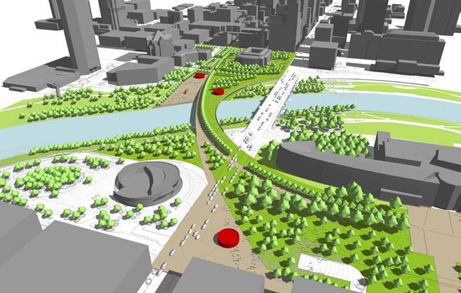
Weave It
CONCEPT 3
Considering that the Broad Street bridge has been reconstructed a number of times over the years, in its current form it presents an iconic and stately form over the Scioto. In an effort to experience the river corridor, while also respecting the existing infrastructure, this concept explores the opportunity to develop a series of pedestrian scaled crossings as activators.

Bridge It
CONCEPT 4
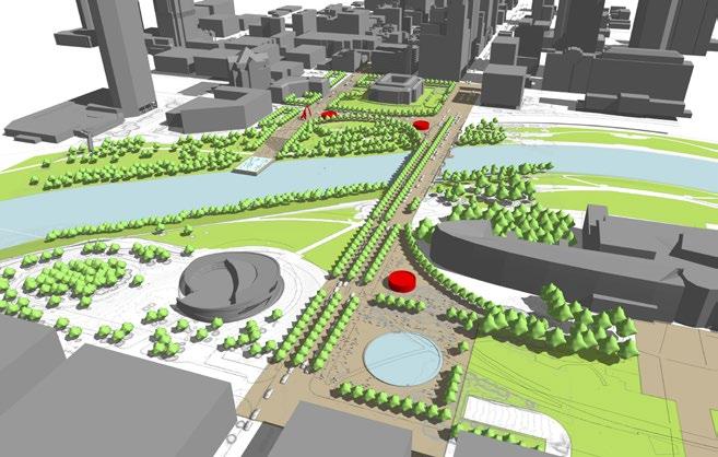
An ambitious idea in the image of cities such as London and Rome, developing an iconic bridge experience that utilizes the Broad Street bridge as a place. Activating the edges with new program, retail and public space opportunities would extend the fabric of the city from High Street to Belle Street with a physical link that enhances the experience.

DOWNTOWN COLUMBUS | THE CAPITAL LINE & CULTURAL PARK 29
DESIGN STRATEGIES
Stitch It
Create a Terminus to Gay Street With an Iconic Public Space:
The Gay Street “Living Room” would extend from Front Street through the Civic Campus with a promenade space and additional green spaces leading to a public art installation at the riverfront at Marconi Boulevard. Continuing further down the banks of the river would extend to the river’s edge with a public “bath” and gathering space for people to lounge and socialize.
Create a Flexible Public Plaza Space at City Hall to Connect the Capital Line:
Activating the edges of City Hall with new open green spaces will make the space feel more inviting to people. It also represents a powerful example of the city’s interest in giving back public spaces to people through flexible plazas for organizing and events, as well as green spaces that enhance the urban experience.
Build a Pedestrian Promenade on the Broad Street Bridge:
Extending the Capital Line trail up and across the Broad Street bridge would require the reduction of vehicular traffic to make way for more pedestrians and cyclists. Considering the future LinkUS plan for the bridge, public transit through BRT will add to a more pedestrian oriented roadway section that would seem attainable.


DOWNTOWN COLUMBUS | THE CAPITAL LINE & CULTURAL PARK 30
CONCEPT 01 CDDC RIVERFRONT STUDY CONCEPT 01 CDDC RIVERFRONT STUDY CONCEPT 01 CDDC RIVERFRONT STUDY
CONCEPT 1


DOWNTOWN COLUMBUS | THE CAPITAL LINE & CULTURAL PARK 31
New York, New York
The High Line
Aarhus, Denmark Aarhus Harbor Bath
Paris, France Tuileries Garden Fountain
Thread It
Create a Terminus to Gay Street at the Water’s Edge:
The Gay Street “Living Room” would extend from Front Street through the Civic Campus with a promenade space and additional green spaces leading to an activated retail kiosk in a flexible urban plaza space. Continuing further down the banks of the river would extend to the river’s edge with tiered seating elements and the potential for a performance amphitheater for intimate concerts.
Bridge Over the River to Extend the Green Space and Provide More Public Space:
A stand-alone pedestrian bridge would extend green space adjacent to City Hall across the Scioto and connect up with the Dorrian Green at COSI. By bringing the grade up to street level, more usable green space could serve a number of recreational purposes, including flexible lawns for ball fields, dog parks and lounging along the river.
Bring the Capital Line Through the Linear Park Space to Connect to the Peninsula:
The Capital Line would transition from the urban edges of the city through this extended park space, helping to activate the edges of the promenade with a shared bicycle and pedestrian experience. The pathway would be void of cars or other vehicles helping to create safe passage from Downtown to the Peninsula.
Connect Dorrian Green with the Civic Gardens at City Hall to Create an Iconic Destination:
Connecting newly activated park space from City Hall to Dorrian Green would create an iconic, powerful image for the city and its belief about public space. The benefit of adding much needed park space downtown with a multitude of continuous activity would add great value for residents and visitors for years to come.


DOWNTOWN COLUMBUS | THE CAPITAL LINE & CULTURAL PARK 32
CONCEPT 02 CDDC RIVERFRONT STUDY CONCEPT 02 CDDC RIVERFRONT STUDY CONCEPT 02 CDDC RIVERFRONT STUDY
CONCEPT 2
DESIGN STRATEGIES


DOWNTOWN COLUMBUS | THE CAPITAL LINE & CULTURAL PARK 33
Berlin, Germany River Spree Beach Bar
Seoul, South Korea Pedestrian Bridge
New York, New York Hunter’s Point South Park
Weave It
Connect Gay Street and the Capital Line to the Peninsula Through an Experiential Park:
The Gay Street “Living Room” would extend from Front Street through the Civic Campus with a promenade space that transitions into a landform that would shape a flexible urban plaza space. Extending from this centralized gathering space, a series of pedestrian promenade would weave to the water’s edge, in and around the Broad Street bridge to connect to COSI and Veterans Memorial.
Create a Flexible Plaza at City Hall to Act as a Destination for the Park:
The flexible plaza space that anchors City Hall to the west, would help to provide grounding to the building, while also drawing attention to the original “front door” with Greek columns. The plaza space could be a space for gatherings to occur, with a skate rink in winter, summer concerts and additional programs.
Develop Smaller Scaled Pedestrian Bridges to Connect to the River and the Peninsula:
The smaller scaled pedestrian bridges would provide for varied experiences above and below the street level. Each of these pathways would lead to pieces of art, retail kiosks and recreational opportunities at the water’s edge. Moving west, pathways would connect to the Veterans Memorial, COSI and Dorrian Green.
Go Underneath the Broad Street Bridge to Connect Through to the Peninsula and Dorrian Green:
Utilizing the Broad Street bridge to connect the Capital Line above, a lower pathway would create an enhanced experience underneath the bridge with integral lighting, public art, and infrastructure. These enhancements would celebrate the experience of the bridge both above and below the street level to create a unique urban space.


DOWNTOWN COLUMBUS | THE CAPITAL LINE & CULTURAL PARK 34
CONCEPT 03 CDDC RIVERFRONT STUDY CONCEPT 03 CDDC RIVERFRONT STUDY CONCEPT 03 CDDC RIVERFRONT STUDY
CONCEPT 3
DESIGN STRATEGIES


DOWNTOWN COLUMBUS | THE CAPITAL LINE & CULTURAL PARK 35
New York, New York Hunter’s Point Park
Puyangjiang, China
Puyangjiang River Corridor
Almaty, Kazakstan Pedestrian Bridge
DESIGN STRATEGIES
Bridge It
Create
a Terminus to Gay Street With an Iconic Eatery, Brewery or City Winery:
The Gay Street “Living Room” would extend from Front Street through the Civic Campus with a promenade space that opens up to an iconic activated pavilion at the water’s edge. This two-story structure would help to transition grade from the street level, while providing activation at both the upper level at Marconi and the lower level at the Scioto River. The pavilion structure could also serve to transition the Capital Line from the plaza space through an additional piece of “wedge” infrastructure to better connect to the Broad Street bridge.
Connect the Capital Line Infrastructure to the Edges of the Broad Street Bridge to Add Activation:
Two “wing” connectors to the north and south of the Broad Street bridge would add needed activation along the edges, lined with eateries, food and beverage opportunities to help transition the Capital Line trail from City Hall through to the Peninsula.
Extend the Street Life of Broad Street Over the Bridge to Pull the Urban Experience Through to the Peninsula:
Adding further activation along Broad Street from High through to Belle Street at the Peninsula would give the appearance of an extended street life that would seamlessly connect downtown to the Peninsula. Strategically placing kiosk retail, food and beverage establishments along this pathway would further add activity that will keep pedestrians moving to varies destinations in the city.
Create an Activated Edge to COSI at Broad Street:
Entering the Peninsula along Broad Street presents an opportunity for COSI to create a “front door” that would address this as a main point of entry. In addition, the Capital Line would come through at some point between COSI and Belle Street as you approach Dorrian Green. Creating more of an active pedestrian street with building edges, a flexible plaza space, and varied amenities and retail would add much needed attractions as you connect to the Junto Hotel and other mixed-use options to the west of COSI.


DOWNTOWN COLUMBUS | THE CAPITAL LINE & CULTURAL PARK 36
4 CONCEPT 04 CDDC RIVERFRONT STUDY CONCEPT 04 CDDC RIVERFRONT STUDY CONCEPT 04 CDDC RIVERFRONT STUDY
CONCEPT


DOWNTOWN COLUMBUS | THE CAPITAL LINE & CULTURAL PARK 37
New York, New York William Vale Hotel
Paris, France Place de la République
Slussen, Stockholm Slussen City Center
STRATEGIES TO CONNECT
THE CULTURAL PARK
Connecting the City from Downtown to the Peninsula
A core outcome of the continued study of public space connectivity downtown was the notion that a pedestrian should be able to safely and intuitively manage to pass from the recent activity at High and Gay Streets to new development at the Peninsula. With the installation of Janet Echelman’s “Current” public art piece along with new restaurants and retail offerings at Gay Street through to the civic campus at City Hall there is tremendous opportunity to activate this forgotten passage. Advancement of these ideas lead to a number of design strategies that illustrate better connections across these development centers through public realm enhancements and infrastructure upgrades that would enhance the experience of Downtown along the Scioto Greenways.
Stitch It
CONCEPT 1
Strategic Infrastructure Improvements Needed
Limited Interventions at the Water’s Edge
Minimal Construction at City Hall
Most Feasible Option for Implementation in Short-Term

Bridge It
CONCEPT 4
Bridge “Extensions” Would Require Increased Investment
Limited Intervention at Water’s Edge
City Hall Landscape Would Require Investment
Creates Best Opportunity for Connecting the Capital Line to Bridge Structure

DOWNTOWN COLUMBUS | THE CAPITAL LINE & CULTURAL PARK 38
+

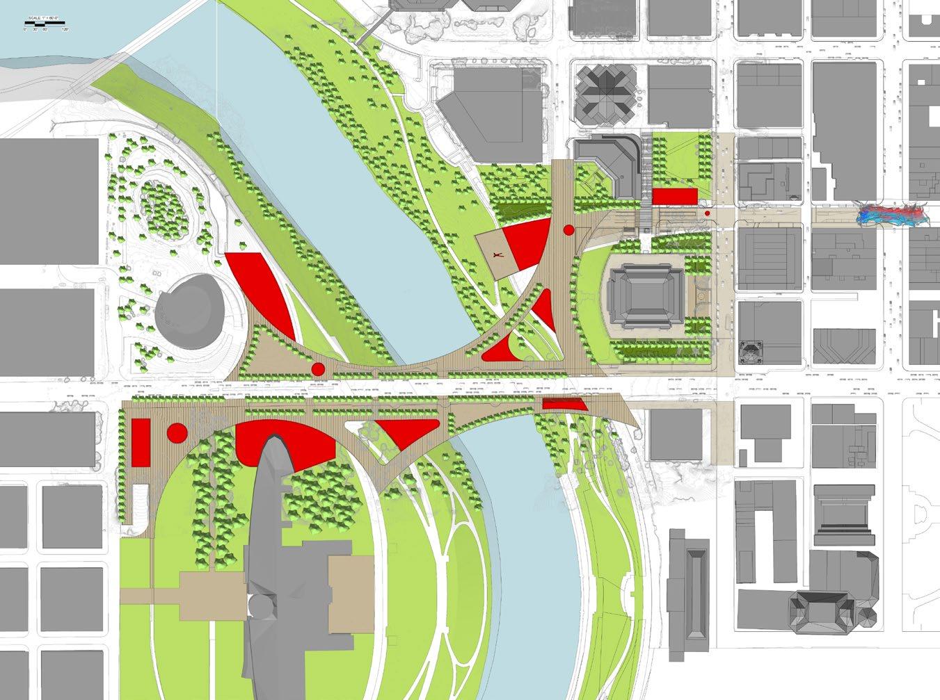
The Concept Plan
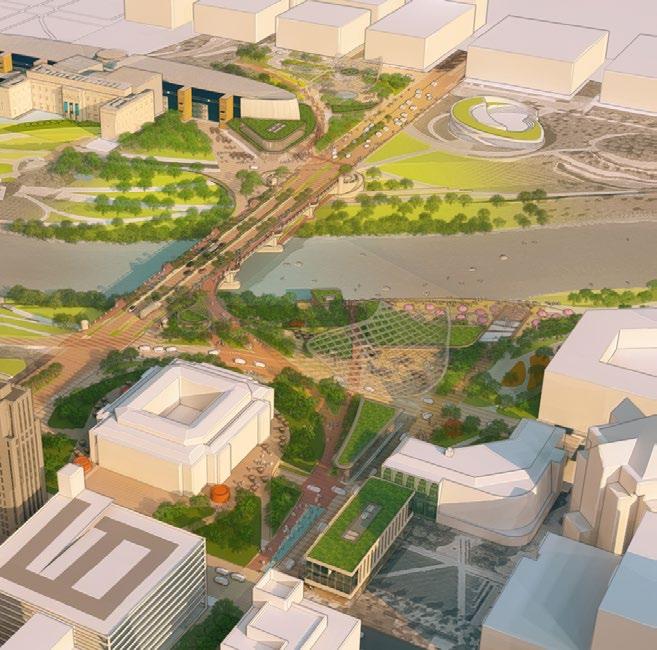
The illustrative plan intricately outlines a comprehensive framework of public spaces and programs, meticulously crafted to forge a new destination. Positioned as ‘the stitch,’ this envisioned locale seamlessly connects downtown to The Peninsula. Within these pages, the narrative unfolds, underscoring the driving force and intention behind this ambitious endeavor: to cultivate a vibrant hub of cultural celebration destined to redefine Columbus.
DOWNTOWN COLUMBUS | THE CAPITAL LINE & CULTURAL PARK 39
THE CULTURAL PARK
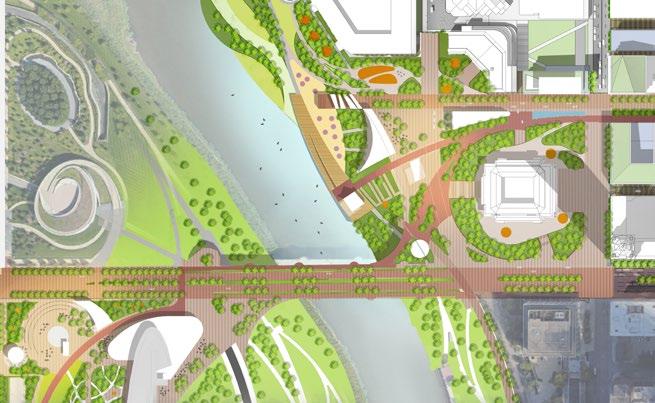
Gateway Feature Kayak Rental Multi-Cultural Center Cultural Gardens Art Installation Retail Kiosk Children’s Play Area Wedge Overlook Overlook Capital Line Sun Deck COSI Gateway Boardwalk Museum Cafè Food Hall Fountain Native Gardens Flexible Plaza River Carousel Science Pavilion 6 6 16 16 7 7 17 17 9 9 19 19 8 8 8 18 18 10 10 20 20 5 5 15 15 4 4 14 14 3 3 13 13 2 2 12 12 1 1 11 11 US DISTRICT COURT
HALL
LEGEND
CITY
COSI
THE CULTURAL PARK VISION
A Vibrant Hub of Cultural Celebration along The Capital Line
Columbus’ Cultural Park embodies a profound opportunity, not solely to elevate the physical landscape along The Capital Line between downtown and The Peninsula, but also to forge a distinctive ‘place’ that reverberates with the unique cultural essence of our city.
Within the following pages, we embark on a nuanced exploration, delving into the foundational elements that shape our identity: our rich heritage, storied civic and governmental history, vibrant art scene, culinary delights, melodic harmonies, and the very contours of our physical terrain.
LEGEND
Gateway Feature Kayak Rental
Multi-Cultural Center Cultural Gardens
Art Installation Retail Kiosk
Children’s Play Area Wedge Overlook
Columbus’ Cultural Park will stand as a testament to the city’s commitment to unity, art, and inclusivity. It embodies the shared values and vibrant tapestry of cultures that define our city—a place where differences are celebrated, and the threads of diversity are woven into the very fabric of our communal identity.
Columbus History, Art and Culture
Extending gracefully over the flowing waters of the Scioto River, Harmony Park will emerge as a sprawling testament to unity, bridging the vibrant core of Downtown Columbus with the burgeoning Peninsula Development to the west. This visionary public park, a graceful gesture that stretches over Columbus’ Scioto Mile and its scenic riverbanks, is poised to redefine the city’s embrace of human connectivity.


Civic & Government Landscape

Heritage Art Cuisine Music


Programs & Activators
Upon entering the park near City Hall, an array of scents from various cuisines will intermingle in the air, welcoming all to explore the culinary treasures within. Small pavilions and food stalls will be placed along pathways, offering a global sampling that mirrors the city’s rich cultural tapestry.


National Museum & DOWNTOWN COLUMBUS 40
CONCEPT PLAN
Food
Fountain Native Gardens
River Carousel Science Pavilion 6 16 7 17 9 19 8 18 10 20 5 15 4 14 3 13 2 12 1 11
Overlook Capital Line Sun Deck COSI Gateway Boardwalk Museum Cafè
Hall
Flexible Plaza

1 2 3 4 5 6 7 8 8 9 10 11 12 13 14 15 16 17 18 19 20
Veterans & Memorial
Celebrating Columbus History, Art and Culture


Heritage
The Scioto Riverfront connects the History of the City of Columbus, supporting Native Americans before the use of the river for transportation and shipping.
Civic & Government
As the capital city of Ohio, Columbus has led the state throughout time in many ways. This civic purpose has led to opportunities for all.
Landscape
While the function of the Scioto River has transformed over time, its importance remains true as an ecological and social amenity.
DOWNTOWN COLUMBUS | THE CAPITAL LINE & CULTURAL PARK 42
COLUMBUS’ CULTURAL DIVERSITY
PARK CHARACTERISTICS


Art
As the city has grown, it has invested in local and worldrenowned art to transform the city fabric.
Cuisine
The diversity of the city can be observed through its food scene. From high-end to small market vendors, Columbus has it all.
Music
Columbus’s musical performances and venues spread throughout the city year-round. Annual festivals build excitement from locals and travelers alike.
DOWNTOWN COLUMBUS | THE CAPITAL LINE & CULTURAL PARK 43
COLUMBUS’ CULTURAL DIVERSITY
The Scioto River’s Role for Columbus
Even before Columbus was established as a city, the riverfront drew in Native Americans, the best known group being the Mound Builders of the Hopewell tradition, and other settlers who were attracted to the agricultural advantages it provided, including floodplains fertile for growing crops.
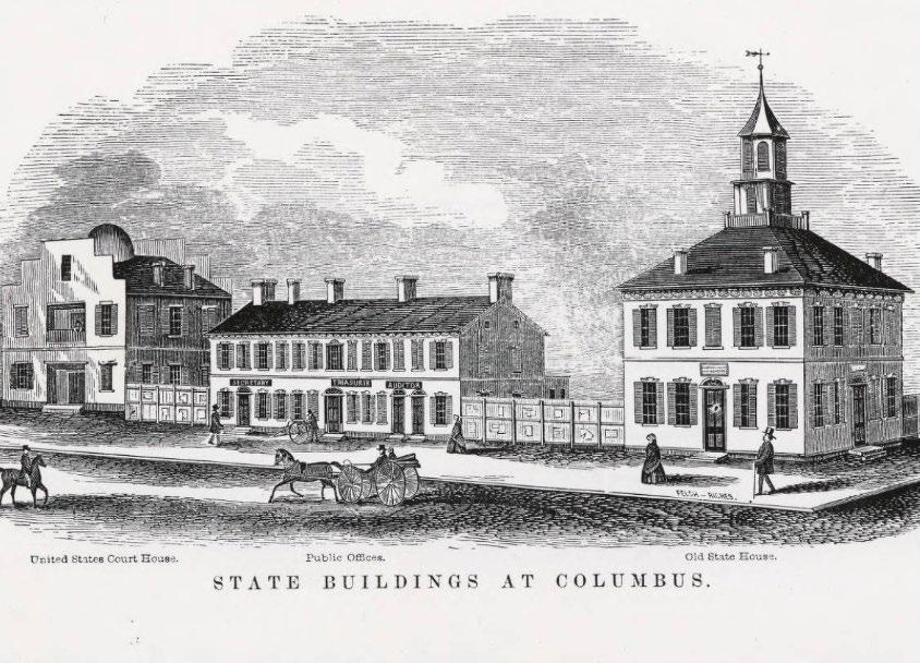
Since its founding in 1816, Columbus has gone through many changes to meet the needs of residents. These changes are particularly evident along the banks of the Scioto River downtown. In 1830 the opening of the feeder canal linked the Ohio-Erie Canal became a means of limited transportation and shipping opportunities. The arrival of the National Road in 1883 further improved connectivity, but Columbus took an even bigger leap forward with the Xenia and Columbus Railroad in 1850. The railroad continued extending and its connection to Columbus turned the city into an industrial power eventually giving it a key role in the Civil War.
As Columbus’ population grew, so did the uses of the riverfront - and not all of them pleasant. The careless of industries and individuals caused the water to become polluted by garbage, sewage and manufacturing waste by the mid to late 1800s. They city began its first shot at riverfront revitalization in the early 1900s, but implementation was stalled when Columbus was hit by the Great Flood of 1913.
Urban Renewal came in the 1950s and resulted in the demolition of a multitude of blighted buildings and widening of the river through a series of dams. The new dams widened and deepened the river, and also helped prevent the sorts of floods the downtown area had previously seen. Unfortunately, the dams also made the river slow, difficult to navigate and, sometimes unpleasant to be near.
In 2010 Government and civic leaders sought ways to breath new life into Downtown Columbus and determined by removing two low head dams new development could begin in areas that had once been underwater. The Main Street Dam and Fifth Avenue Dam were both removed by 2013 restoring the river’s natural flow and improving its ecosystem.


DOWNTOWN COLUMBUS | THE CAPITAL LINE & CULTURAL PARK 44 HERITAGE
MOUND BUILDING ALONG THE SCIOTO RIVER
1895 - FUTURE GRIGGS DAM LOCATION
1918 - GRIGGS DAM & RESERVOIR
1930 - SWIMMING ON THE SCIOTO RIVER
1880 - COLUMBUS FEEDER CANAL
1913 - THE GREAT FLOOD OF 1913


COLUMBUS’ CULTURAL DIVERSITY
A Thriving State Capital
In 1795, Lucas Sullivant came into the Ohio country as a surveyor and received his pay in land near the junction of the Scioto and Olentangy rivers. After establishing Franklinton in 1797, Sullivant built a cabin on his land then left to go pick up his wife and head back to Ohio. When Sullivant returned to Franklinton, he found nobody there and no town. The river had risen in one of the eleven floods that would ravage the area over the next century.
The land across the river was called “high banks” and was on the ground that Moundbuilder people had built a 40-foot-high hill of earth and gravel that would be livable during times of high water. Although Sullivant longed to live on the high banks, that land belonged to the Refugee Tract which was set aside for people in Nova Scotia who lost property because of their loyalty to the American Revolution.
By 1812, a new capitol city called Columbus had been created on the high banks and was beginning to grow in its own right. Franklinton was being eclipsed by the new town across the river. The early settlement struggled with flooding and was inundated no fewer than eleven times between 1797 and 1913 leading to the new investment, repairs or improvements were restricted by law in this area.
Ohio’s capitol building, known as the Ohio Statehouse, was one of the first buildings to be constructed as a state capitol. Considered one of the best examples of Greek Revival architecture in America, construction of the Ohio Statehouse began in 1839. It wasn’t completed until 1861, a few months after the First Battle of Bull Run, the first major battle of the Civil War.
The Plan of the City of Columbus in 1908 focused on three main groups: (1) Those having to do with the city as a whole - The General Survey; (2) Those having to do with a Park System; (3) Those having to do with a State or Civic Center. The City of Columbus represents the mingling of two distinct types of cities, with a considerable injection of a third type. It is at once a capital city and an industrial city and, secondarily , it is an educational center.
DOWNTOWN COLUMBUS | THE CAPITAL LINE & CULTURAL PARK 45
& GOVERNMENT
CIVIC
1816 - FIRST STATEHOUSE IN FRANKLINTON
1850 - OHIO STATEHOUSE DRAWING
1861 - OHIO STATEHOUSE
1908 - COLUMBUS VISION PLAN
1913 - THE GREAT FLOOD OF 1913 AT BROAD ST.
1908 - COLUMBUS VISION PLAN
COLUMBUS’ CULTURAL DIVERSITY
A Resource Worth Preserving
While Columbus may be remembered for many things, it’s native landscapes may not be one of them.
People have been traveling through central Ohio on the Scioto and Olentangy rivers for hundreds of years. Long before colonial explorers arrived in the Midwest, Native Americans had reached the understandable conclusion that travel on the inland rivers rather than through narrow forest paths of the Ohio country made a certain amount of sense.
While passing through Downtown Columbus today, the Scioto River looks almost unrecognizable compared to what it once was. In the late 1790s the river was considerably narrower and much deeper than it is today, and dotted with sandbars and occasional islands. In the early days, people spent much of their time along the river. It was a place to swim, to fish and to find a nice place to spend a little quiet time. It also was a place to have a party from time to time. The numerous islands in and along the river provided an easily accessible venue for people to have a little fun away from the hustle and bustle of Columbus. Some of the people seeking privacy on the islands were simply looking for a nice place away from it all.
After Lucas Sullivant began surveying parts of a tract of land known as the Virginia Military District on the west side of the Scioto, it did not take him long to realize people had been living at this place for a very long time already. A large Indian mound, more than 40 feet tall, towered above the high ground on the eastern side of the Scioto River. Covered with mature forest trees, the mound that gave Mound Street its name obviously had been there for a while.


DOWNTOWN COLUMBUS | THE CAPITAL LINE & CULTURAL PARK 46
LANDSCAPE
1899 - SCIOTO RIVER
1915 - SCIOTO RIVER
1930s - SCIOTO RIVER
1983 - SCIOTO RIVER
2023 - SCIOTO RIVER
2013 - SCIOTO RIVER

ANN HAMILTON
Renowned artist from Columbus, OH

2014 — SCIOTO LOUNGE
Terry Allen

2023 — MURAL FEST
Felipe Pantone

2001 — ART
Rick Petry
2021 — THE MAKERS MONUMENT
Mark Reigelman

2023 — CURRENT
Janet Echelman
COLUMBUS’ CULTURAL DIVERSITY
ART A City of Artists
Part of what make Columbus such a culturally rich destination is the thriving arts scene it boasts. Home to hundreds of galleries & studios, special events, and one of the best art schools in the country, it’s easy to find inspiration around every corner. Columbus’ art scene is bursting with creativity from independent artists, professional troupes and artists-in-residence.
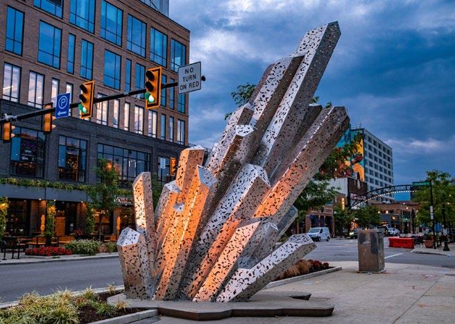
The Columbus Museum of Art is home to the Pizzuti Collection, view the work of contemporary artists at the acclaimed Wexner Center for the Arts, or view the largest collection of Franklin County artists just by walking the halls of the Greater Columbus Convention Center. The Columbus Arts Festival also features more than 280 nationally acclaimed artists that take overs the downtown riverfront with local art, entertainment and food.
Just north of downtown is a vibrant sector of art and culture. Beginning in 1980, a handful of people who were integral in founding the Short North Arts District worked hard to create its identity as a place where artistic culture and small businesses are celebrated. Today, the Short North Arts District is the most vibrant spot in the City of Columbus and is home to over 300 businesses. A similar revitalization is beginning to happen in Franklinton. The Franklinton Arts District is located just west of downtown and features artist studios, performance venues, galleries, and maker spaces.
During this past June, the skyline of downtown Columbus was transformed after unveiling Current, a monumental artwork by internationally recognized sculptor Janet Echelman. The 229-footlong soft fiber sculpture is suspended above the intersection of Gay Street and High Street and stretches 126 feet in the air at its highest point. After installation, Mayor Andrew Ginther said, “Visible from an airplane, Current will be a beacon and a beckon, drawing people from across the city and region. It’s going to be a defining image for our downtown and put Columbus on the map as a community that cares about — and invests in — transformational public art.”
DOWNTOWN COLUMBUS | THE CAPITAL LINE & CULTURAL PARK 47
Food as Part of our City-Wide Identity
Columbus is rapidly gaining a reputation as one of America’s up-and-coming culinary destinations. Its restaurant scene is creating a buzz with its creativity, diversity and one-of-a-kind experiences, from classic diner fare, to fine dining, to offbeat, ethnic and funky cafes.
Columbus is home to restaurateur Cameron Mitchell, owning and operating 25 different restaurants in Columbus, and the James Beard Award-winning cookbook author Jeni Britton, the mind behind Jeni’s Splendid Ice Creams, both with locations located throughout the city. Columbus also supports a large immigrant, particularly refugee, population. With waves of new arrivals bringing aspects of their culture over, we are able to experience the full flavors of cultural dishes. Immigration here in Columbus tends towards arrivals from Somalia, Ethiopia, India, and Nepal.
Many food legends hail from Columbus — including Guy Fieri, the infamous man from Flavortown. Recently, Fieri has decided to open his first restaurant in Columbus alongside running a yearly music-food festival, boasting a solid lineup of food, chefs, and live music. Avishar Barua, talented chef behind Joya’s Cafe and Agni, recently competed against Bobby Flay on Food Network’s show “Beat Bobby Flay” in 2023 and did just that. More recently, Alexia Orsburn, executive chef at Littleton’s Market, was crowned Chopped Champion and said, “Not only was being selected for Chopped a professional accolade, but it was also a deeply personal and transformative experience. I loved the opportunity to push boundaries, embrace the unexpected and compete against other very talented chefs. It was a great opportunity to learn, grow and share my culinary journey with a global audience.”


DOWNTOWN COLUMBUS | THE CAPITAL LINE & CULTURAL PARK 48
CUISINE
COLUMBUS’ CULTURAL DIVERSITY
AGNI: LIVE FIRE RESTAURANT
MO MO GHAR
CAMERON MITCHELL RESTAURANTS
1814-1966 — COLUMBUS’ CENTRAL MARKET HOYO’S KITCHEN
JENI’S ICE CREAM


COLUMBUS’ CULTURAL DIVERSITY
MUSIC & PERFORMANCE
The Performance Scene is Unmatched in Columbus
Arenas and Stadiums:
• Nationwide Arena — 200 W. Nationwide Boulevard
• Ohio Stadium — 411 Woody Hayes Drive
• Schottenstein Center — 555 Borror Drive
• Historic Crew Stadium — One Black and Gold Boulevard
Concert Halls:
• The Bluestone — 583 E. Broad Street
• KEMBA Live! — 405 Neil Avenue
• Newport Music Hall — 1722 N. High Street
• Skully’s Music Diner — 1151 N. High Street
Theaters:
• Shadowbox Live! — 503 S. Front Street
• Ohio Theatre — 39 E. State Street
• Palace Theatre — 34 W. Broad Street
• Lincoln Theatre — 769 E. Long Street
• Southern Theatre — 21 E. Main Street
• Riffe Center — 77 S. High Street
Intimate Settings & Bars:
• Ace of Cups — 2619 N. High Street
• A&R Music Bar — 391 Neil Avenue
• The Big Room — 1036 S. Front Street
• The Basement — 391 Neil Avenue
• Natalie’s Music Hall & Kitchen — 945 King Avenue
• Kafe Kerouac — 2250 N. High Street
• Rumba Cafe — 2507 Summit Street
• The Summit Music Hall — 2210 Summit Street
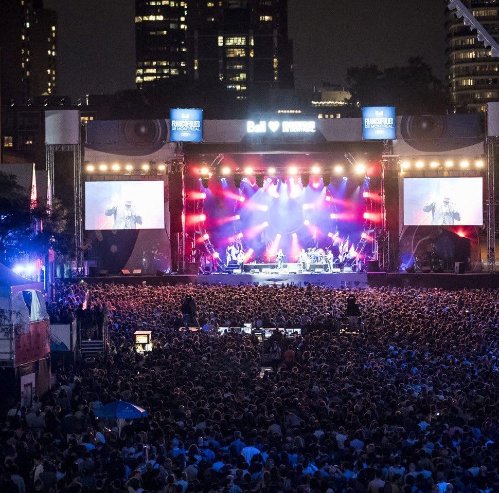
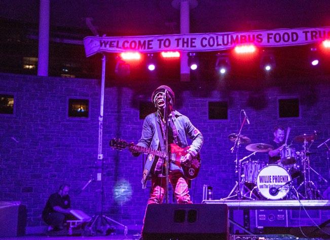
Annual Festivals:
• Breakaway Music Festival — Historic Crew Stadium
• Buckeye Country Superfest — Ohio Stadium
• Sonic Temple Music & Art Festival — Historic Crew Stadium
• Haunted Fest — KEMBA Live!
• WonderBus Festival — 2540 Olentangy River Road
DOWNTOWN COLUMBUS | THE
LINE & CULTURAL PARK 49
CAPITAL
2001 — KEMBA LIVE!
2024 — CAPA AMBRY MUSIC HALL
2016 — MUSIC COLUMBUS TRAIL
2010 — COLUMBUS COMMONS MUSIC SERIES
2021 — 70’s MUSIC EXPLOSION IN COLUMBUS
2024 — COLUMBUS SYMPHONY ORCHESTRA
Creating Experiences that Celebrate Our Culture
1. Waters Edge: Create a landscape experience that honors Indigenous people and their relationship to the river.
2. Native Landscape: Develop a landscape palette and expression that celebrates the ecological diversity of the Scioto River.
3. Cultural Gardens: Create a series of cultural gardens that highlight the diverse cultures of Columbus.
4. Learning Spaces: Design an inclusive play and educational zone that accommodates children and adults.
5. Cuisine: Celebrating diverse cultures through ethnic cuisine within the community by incorporating food stalls, cafes, or eateries.
6. Music: Highlighting the sounds from throughout the world by developing a series of outdoor performance spaces.
7. Government Center: Highlight significant and notable people and events in the City’s history.
8. Innovation Hubs: Activate the public realm with transparent architectural pavilions that provide meeting and exhibit spaces.
9. Gathering Spaces: Create the opportunity for large gatherings and festivals.
10. World-class Art: Anchor key public spaces with iconic artworks that become international destinations along the Capital Line.


DOWNTOWN COLUMBUS | THE CAPITAL LINE & CULTURAL PARK 50
PARK EXPERIENCE
CULTURAL
IT’S ABOUT PEOPLE!
Edge Government Center Native Landscapes
Waters
Music


DOWNTOWN COLUMBUS | THE CAPITAL LINE & CULTURAL PARK 51
Innovation Hubs Cultural Gardens
Gathering Spaces Learning Spaces
World Class Art Cuisine
The Community Hub of the Future
“City Halls Around the World are Opening Their Doors and Ushering Community Members Inside.” The Community Hub of the Future isn’t a Library or a Shopping Center. It’s City Hall.
— Emily Nonko
Inward Focused
There is one place the modern city halls has yet to stick: The United States. Although there has been much work to diversify libraries and federal buildings in the U.S., the challenge of reinventing the city hall deals with visionary leadership, securing funding and safety concerns.
Outward Focused
New designs are making city halls vibrant public spaces that are more inviting and engaging. This further strengthens the bond between citizens and their local government. It’s about creating a space where community members can come together, share ideas, voice concerns, and work together to build a better future for their city.
DOWNTOWN COLUMBUS | THE CAPITAL LINE & CULTURAL PARK 52 CITY HALL’S ROLE
ASPIRATIONAL PROFILE: CITY HALLS
Around the globe, City Halls are being transformed into community centers for all citizens.
The Community Hub of the Future isn’t a Library or a Shopping Center. It’s City Hall.
— Emily Nonko


KIRUNA’S CITY HALL REICHSTAG
KIRUNA, SWEDEN BERLIN, GERMANY
The city hall in Kiruna is known as one of the best place for citizens to spend their times. It contains a public café, a stage, seating nooks, and areas to accommodate dance classes and choir performances. The upper floors contain a public art museum with contemporary work from around the region. Every floor is accessible to the public, with only offices and the chamber off-limits. The city hall embodies a place where citizens can act out democracy along elected officials, enjoying the simple pleasure of grabbing a coffee with friends or browsing an art collection while doing so. The city hall has been nicknamed the “communal living room of the future” - which is portrayed through its flexibility and multi-use.
The Reichstag is the parliament building for the Bundestag. Norman Foster redesigned the building in the late 20th Century, after a fire rendered the original building useless over 50 years before. The new building was meant to show democracy happening, and put it on display for citizens. The top of the structure is now covered with a glass cupola that looks through the roof of the building, straight to the congressional chamber. The equivalent in the United States would be the ability to stand at the top of the Capital dome and watch Congress deliberate. While a sort of impossible thought for most, this openness has exposed many to democracy, creating a living museum of sorts.


LONDON CITY HALL ETOBICOKE CIVIC CENTRE
LONDON, ENGLAND
London’s city hall has a unique exterior shell, the silvery egg-like shape standing out among the urban landscape. When it opened in 2002, one would not have expected a ramp on the interior, bringing constituents up towards the meeting chamber of the assembly. The public space at the building’s apex puts citizens “above” the government, in a sense. The space is meant to cross barriers between government and the people, creating another space for people to connect. Instead of more office-space or meeting rooms, it was a deliberate decision to give civic space back over to the public.
TORONTO, CANADA
The new Civic Center in Toronto is meant to reflect its diversifying population - with spaces for every activity one could imagine. The center itself is a series of buildings lining a public square, shielded from the elements. The intent of the designer was for the center to serve as a display of democracy at work for those arriving to the city from nondemocratic countries. It is packed full of public spaces open for all Toronto residents to interact. Functions within the center will include a myriad of amenities, including a pool, daycare, library, and recreation center.
DOWNTOWN COLUMBUS | THE CAPITAL LINE & CULTURAL PARK 53
THE CULTURAL PARK VISION
Developing the Stitch from East to West
The Capital Line infrastructure represents the highest level of connection amongst the downtown assets and attractions. With the development of the trail along the north side of Broad Street, it will be important to transition from Gay Street, through the cultural park to move pedestrians and cyclists to the bridge promenade. In doing so, consideration of transition “wedge” infrastructure components should be carefully studies to aid in this transition.
In addition, moving west to the Peninsula presents opportunities to create a new gateway as pedestrians transition across Broad Street and into the Dorrian Green. The West Culture Park could present opportunities for COSI to create outdoor exhibit spaces and active programs that would provide activity along Broad Street. A proposed building addition could further create a front door along Broad, and help to create more prominence for the Veterans Memorial as well.

COSI
Veterans Museum & Memorial
Culture Park N 350’ DOWNTOWN COLUMBUS | THE CAPITAL LINE & CULTURAL PARK 54
The Peninsula National
West
CONCEPT PLAN
 LeVeque Tower
City Hall
US District Court
East Culture Park
LeVeque Tower
City Hall
US District Court
East Culture Park
DOWNTOWN COLUMBUS | THE CAPITAL LINE & CULTURAL PARK 55
The Capital Line Broad Street Bridge
Inspiring People through Programmable Public Spaces
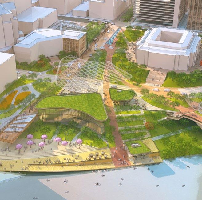
In its current state, the connection between the riverfront and the city lacks programming. The introduction of varied public spaces will encourage the use of these new areas for activities beyond the jogging and strolling that occurs today. Destinations will begin to emerge that will better connect the Downtown core with the Peninsula, creating an ebb and flow between activated spaces.
New pavilions and kiosks will contain vendors, food and beverage, and other retail opportunities such as equipment rental. Smaller plaza spaces will create more intimate gathering areas for conversations, while public connector spaces will encourage strolling between destinations.
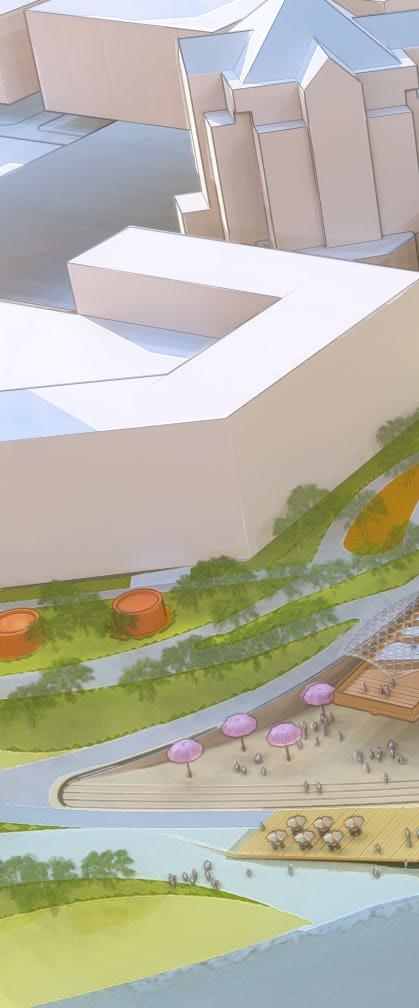
The Sandbar Sun Deck (urban beach) space has the ability to create a unique experience within the city as an iconic attraction. Each program is important in its own way, drawing visitors for the collection of varied experiences helping to draw users from all walks of life and help to break down barriers within communities.


Cultural Gardens “Pillars of Science” Pavilion “Elements Plaza” / Water Feature Cafe Inclusive Play Area N 350’ DOWNTOWN COLUMBUS | THE CAPITAL LINE & CULTURAL PARK 56
Areas
Scale Public Spaces Waterfront Programming
Public Space
/ Eateries
CONCEPT PLAN Naturalized
Small
Interconnected
Structures
LEGEND PROGRAM TYPOLOGIES
Café / Restaurant Native Plantings Plaza Seating Sun Deck Overlook Boardwalk Kayaking Dog Park World-Class Art Children’s Play Public Restroom Waters Edge Kiosks Performance STRUCTURES / EATERIES a place for... Socializing, Gathering, Dining INTERCONNECTED PUBLIC SPACE a place for... Connection, Circulation, Movement SMALL SCALE PUBLIC SPACE a place for... Play, Events, Interaction WATERFRONT PROGRAMMING a place for... Lounging, Strolling, Viewing NATURALIZED AREAS a place for... Respite, Lingering, Shade
Nature Walk (Naturalized Landscape of the Scioto)
Cultural Gardens ‘Pillars of Columbus’
Inclusive Play / Learning
“Embrace” Performance
Overlook
Nature Preserve
Sandbar Sun Deck
Indigenous People’s Walk
Multi -Cultural Eateries
Cultural Gardens Service
City Innovation Hub
Scioto Promenade
Water Feature at Gateway
Cultural Gardens “Pillars of Justice”
Multi-Cultural Center
People’s Plaza with “Harmony” Sculpture
City Hall Plaza
Kayak Rental & Boat Launch
Accessibility & Pollinator Gardens
Public Park
Public Park COSI Entry and Restaurant / Meeting Spaces
DOWNTOWN COLUMBUS | THE CAPITAL LINE & CULTURAL PARK 57
STRUCTURES / EATERIES
a place for...
Socializing, Gathering, Dining
INTERCONNECTED PUBLIC SPACE
a place for...
Connection, Circulation, Movement
WATERFRONT PROGRAMMING
a place for...
Lounging, Strolling, Viewing
SMALL SCALE PUBLIC SPACE
a place for...
Play, Events, Interaction
NATURALIZED AREAS
a place for...
Respite, Lingering, Shade


DOWNTOWN COLUMBUS | THE CAPITAL LINE & CULTURAL PARK 58
Café / Restaurant Seating
PROGRAM TYPOLOGIES World-Class Art Public Restroom Kiosks Performance


DOWNTOWN COLUMBUS | THE CAPITAL LINE & CULTURAL PARK 59
Native Plantings
Plaza
Sun Deck
Overlook
Boardwalk
Kayaking
Dog Park
Children’s Play
Waters Edge
PEOPLE CENTERED PLACES
Vibrant Riverfront Spaces that Foster Community Gatherings and a Sense of Identity
Thoughtfully curated destinations along the riverfront have been designed to enhance the well-being of the Columbus community. These spaces provide opportunities for residents to engage in recreation, leisure, dining and communal interactions, thereby deepening the city’s collective identity. By seamlessly weaving the Scioto riverfront greenway into the city center and extending its influence to the Peninsula through distinct micro-zones, we create a cohesive and memorable urban experience.
City Hall Campus
After crossing Front Street, the new City Hall landscape draws in visitors to an collection of inviting and activated pockets of green space allowing for a more approachable civic campus.
Waterfront Park
The terminus of Gay Street is filled with a variety of amenities and people space that will not only be a spot for residents to enjoy, but an attraction for visitors from within the region.
DOWNTOWN COLUMBUS | THE CAPITAL LINE & CULTURAL PARK 60
RIVERFRONT MICRO-ZONES
Water’s Edge
A new water’s edge promenade allows park users to experience the Scioto River in a new way by getting closer to the water connecting to varied recreational activities.

Broad Street Bridge
The new Broad Street bridge experience provides an extension for the Capital Line connecting the Downtown Core to the newly developed Peninsula mixed-use district.
The Peninsula
The Peninsula connector serves as an eye-catching destination drawing pedestrians over the Broad Street bridge to COSI plaza with new eateries and retail offerings extending into Franklinton.

DOWNTOWN COLUMBUS | THE CAPITAL LINE & CULTURAL PARK 61
CITY HALL CAMPUS
After crossing Front Street, the new City Hall landscape draws in visitors to an collection of inviting and activated pockets of green space allowing for a more approachable civic campus.


Existing Conditions VIEW LOOKING
WEST TOWARDS FRANKLINTON FROM DOWNTOWN
LeVeque Tower
 City Hall
Scioto Gateway
Multi Cultural Center
Iconic Art
Marconi Boulevard Children’s Interactive Play
Capital Line Wedge Connection
COSI
National Veterans Memorial and Museum
City Hall
Scioto Gateway
Multi Cultural Center
Iconic Art
Marconi Boulevard Children’s Interactive Play
Capital Line Wedge Connection
COSI
National Veterans Memorial and Museum
GAY STREET PROMENADE

FUTURE INNOVATION CENTER
The future Innovation Center is important to providing opportunities for new buildings within the government campus as well as providing the necessary street-level activation add to the riverfront connectivity.
EXTEND GAY STREET
Extending Gay Street helps to better connect recent investments directly to the Scioto riverfront and can host an activated new street edge in front of a new City Innovation Center to the north.


DOWNTOWN COLUMBUS | THE CAPITAL LINE & CULTURAL PARK 64
Scioto Gateway
Capital Line
Gay Street
City Hall Landscape
Multi Cultural Center
Innovation Center
Activated Street
MULTI CULTURAL CENTER
A Multi Cultural Center provides a visual terminus and activator for visitors walking along Gay Street to help draw them down to the riverfront and closer to new developments on the west side of the Broad Street Bridge.
MULTICULTURAL CENTER


DOWNTOWN COLUMBUS | THE CAPITAL LINE & CULTURAL PARK 65
Multi Cultural Center
Capital Line
Gay Street
WATERFRONT PARK
The terminus of Gay Street is filled with a variety of amenities and people space that will not only be a spot for residents to enjoy, but an attraction for visitors from within the region.

Existing Conditions VIEW LOOKING EAST AT GAY STREET TERMINUS & BATTELLE RIVERFRONT PARK
Overlook Sun Deck Boardwalk
 Multi Cultural Eatery / Market
Iconic Art
Overlook
Boardwalk Nature Preserve
Native Gardens
Scioto Gateway
Capital Line
Kayak Rental / Boat Launch
Kiosk
Kiosk
City Hall
City Hall Landscape Broad Street
Marconi Boulevard
Children’s Interactive Play Scioto River
Multi Cultural Eatery / Market
Iconic Art
Overlook
Boardwalk Nature Preserve
Native Gardens
Scioto Gateway
Capital Line
Kayak Rental / Boat Launch
Kiosk
Kiosk
City Hall
City Hall Landscape Broad Street
Marconi Boulevard
Children’s Interactive Play Scioto River
CREATING A DESTINATION
A new multi-level eatery will anchor a new Cultural Park for Columbus that will celebrate a variety of cuisines, performances and traditions. This will be a destination for not only Downtown residents, but all of Central Ohio that will provide the necessary activity around the riverfront that is missing today.


DOWNTOWN COLUMBUS | THE CAPITAL LINE & CULTURAL PARK 68 ICONIC ART + PLAZA
Flexible Plaza
Multi Cultural Eatery / Market
Iconic Art
ICONIC ART
Similiar to the Janet Echelman sculpture
“Current” at Gay and High, this is another opportunity for a world-class art piece that will serve as a beacon that further enhances a unique sense of place around the riverfront.


DOWNTOWN COLUMBUS | THE CAPITAL LINE & CULTURAL PARK 69
COLUMBUS EATERIES
Children’s Interactive Play
Flexible Plaza
Multi Cultural Eatery / Market
Multi Cultural Center
Iconic Art
WATERS
EDGE
A new water’s edge promenade allows park users to experience the Scioto River in a new way by getting closer to the water connecting to varied recreational activities.


Existing Conditions VIEW LOOKING EAST TOWARDS THE DOWNTOWN CORE
 Boardwalk
Kayak Rental / Boat Launch
Wedge Connector
Sun Deck Overlook
Multi Cultural Eatery / Market
City Hall
Children’s Interactive Play
Boardwalk
Kayak Rental / Boat Launch
Wedge Connector
Sun Deck Overlook
Multi Cultural Eatery / Market
City Hall
Children’s Interactive Play
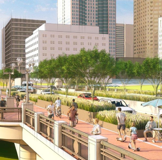
URBAN BEACH / SUN DECK
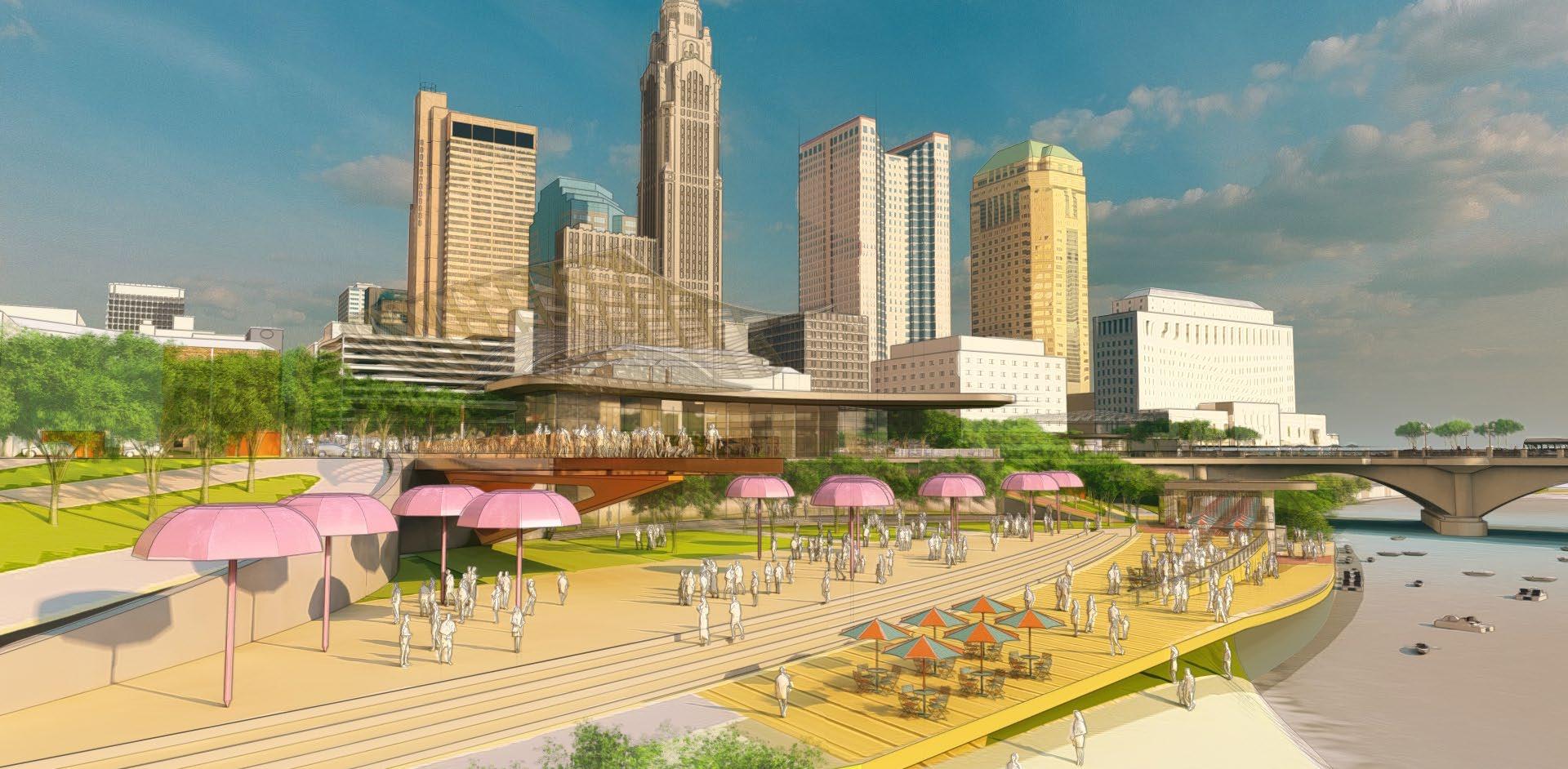
SUN DECK
A unique opportunity for an active “beach scene” near the Scioto River that will become a highly programmable riverfront destination that will bring more activity Downtown.


DOWNTOWN COLUMBUS | THE CAPITAL LINE & CULTURAL PARK 72
Sun Deck
Boardwalk
Scioto River
Broad St. Bridge
Kayak Rental / Boat Launch
Overlook
BOARDWALK
The boardwalk will physically bring visitors closer to the waterfront while increasing the opportunities for water recreational activities such as kayaking and boating.


DOWNTOWN COLUMBUS | THE CAPITAL LINE & CULTURAL PARK 73
KAYAK LAUNCH / RENTAL
Sun Deck
Boardwalk
Scioto River
Iconic Art
Kayak Rental / Boat Launch
Overlook
Multi Cultural Eatery / Market
Native Gardens
BROAD STREET BRIDGE
The new Broad Street bridge experience provides an extension for the Capital Line connecting the Downtown Core to the newly developed Peninsula mixed-use district.


Conditions
VIEW LOOKING EAST ON THE BROAD STREET BRIDGE Existing
 Broad Street Boulevard
Line
Vegetative Buffer
Capital
Seating
THE WEDGE
‘The wedge’ is a new piece of infrastructure that will ease the connection of The Capital Line onto the Broad Street Bridge while also providing stunning views to the programmed riverfront below.


DOWNTOWN COLUMBUS | THE CAPITAL LINE & CULTURAL PARK 76 CAFÈ / PAVILION
Art Kiosk
Overlook
Capital Line
Broad Street
THE CAPITAL LINE
The Capital Line will re-shape the pedestrian experience along the Broad Street Bridge through enhanced paving materials, more landscape elements and new seating opportunities.


DOWNTOWN COLUMBUS | THE CAPITAL LINE & CULTURAL PARK 77
OVERLOOK
Capital Line
Broad Street Boulevard
Scioto River
National Veterans Memorial and Museum
THE PENINSULA
The Peninsula connector serves as an eye-catching destination drawing pedestrians over the Broad Street bridge to COSI plaza with new eateries and retail offerings extending into Franklinton.


Existing Conditions VIEW LOOKING WEST TOWARDS COSI, NATIONAL VETERANS MEMORIAL & THE PENINSULA
COSI
 COSI Addition
Art Pavilion Broad Street Capital Line The Peninsula National Veterans Memorial and Museum
COSI Addition
Art Pavilion Broad Street Capital Line The Peninsula National Veterans Memorial and Museum
COSI ADDITION


COSI / ANCHOR ADDITION
A new addition to COSI or future anchor will not only create more activation on the west side of the Scioto River, but serve as a visual terminus for pedestrians and bikers traveling along The Capital Line.


DOWNTOWN COLUMBUS | THE CAPITAL LINE & CULTURAL PARK 80
Capital Line
Broad Street
COSI Addition
The Peninsula
PLAZA AND ICONIC ART
To create a strong destination on the north end of Dorrian Green, a new plaza and iconic art sculpture are proposed that help to better connect the adjacent anchors and activities.
WEST CULTURAL PARK


DOWNTOWN COLUMBUS | THE CAPITAL LINE & CULTURAL PARK 81
Capital Line
Art Kiosk Broad Street
COSI
Dorrian Green
National Veterans Memorial and Museum
Prioritizing the findings of the Public Realm Master Plan
Initial findings of the 2022 Downtown Strategic Plan Pilot Neighborhood Study began to prioritize a phasing of downtown public infrastructure projects. Specifically outlined below, the focus of this study was in developing a detailed design concept for project Concept 2 as a riverfront activator that better connects downtown to the Peninsula:
1. Core Project 1 / Gay Street Living Room - The Gay Street spine from 4th Street to Front Street including Lynn and Pearl Alley upgrades will be incorporated into an advanced implementation phase through RFP. This design phase will further solidify specific material approaches as well as the street transitions from auto dominant to more of a shared pedestrian roadway scenario.
2. Concept 2 / Waterfront Activation Study - Entering at Front Street, through the City Hall campus and to the Scioto Riverfront, this area is loosely defined with conceptual study in this report. A more detailed conceptual design should be advanced to study program, infrastructure and opportunities for connecting to and through the Riverfront to The Peninsula.
3. Concept 3 / Crossblock Framework Plan - This future planning area should receive additional detailed study as a collection of property owners are in varying phases of proposed development. It would be important to focus on how each of these potential projects could connect and add value to this potential experience as a unique place for the city.
4. Concept 4 / Capital Line Conceptual Design - The Downtown Pedestrian Trail has the ability to connect districts and neighborhoods that are already receiving increased investment in both the public and private space. A more detailed conceptual design focusing on the enhancement of the pedestrian experience is necessary to establish design parameters including branding elements as you traverse it and as it transitions between districts.

CONCEPT 2
destination
Peninsula. 2 PROJECT PHASING DOWNTOWN COLUMBUS | THE CAPITAL LINE & CULTURAL PARK 82 PRIORITY PROJECTS
Creating a highly activated waterfront
while also strengthening the connection to The
Creating a Gateway Plaza & The Crossblock Pedestrian Alley.
CORE PROJECT 1
Transforming Gay Street and adjacent alleys into the 'Living Room' of the neighborhood. 1
Creating The Capital Line, an iconic 2-mile pedestrian loop that connects districts and cultural attractions. 3 4

 CONCEPT 3
CONCEPT 4
CONCEPT 3
CONCEPT 4
DOWNTOWN COLUMBUS | THE CAPITAL LINE & CULTURAL PARK 83
APPENDIX
SUPPORTING STUDIES AND ANALYSIS
THE CAPITAL LINE
CONNECTING NEIGHBORHOODS
DOWNTOWN COLUMBUS | THE CAPITAL LINE & CULTURAL PARK 86
Connecting the Tapestry of Livable Urban Neighborhoods
With renewed interest and investment in the core of downtown, it is important to begin to think of the city as a collection of livable urban neighborhoods if we are to succeed in achieving the Downtown Columbus Inc.’s (CDI) goal of reaching 40,000 downtown residents by 2040. In doing so, city leaders should be considering how to implement a more livable infrastructure with greater access to parks and open spaces, reductions of traffic and high speed vehicular lanes, providing more hospitable places for people to linger and socialize and making it easier for pedestrians to transition between districts.


1. Greenway EXISTING CONDITIONS
The Scioto Greenways project was a major first step in the transition of downtown, unearthing over 30 acres of publicly accessible green space in the heart of the city. With this in mind, and continued development on the western properties in the Peninsula and Franklinton, a paradigm shift is occurring as the center of downtown is now calling you to the riverfront.
3. Central Park CONCEPTUAL REFRAMING
If we considered the Scioto River as a much larger ‘central park’ as it comes through downtown, it underscores the importance of connecting across this significant public space while also recognizing the break in urban connectivity that it creates. Therefore, a more intentional plan and designed experience must be proposed to better stitch together both sides of the river.


2. Capital Line
RE-CENTERING DOWNTOWN
Over the past few decades downtown has seen growth happening on the Peninsula and in Franklinton. We have also seen significant investment at the corner of High and Gay Streets with public infrastructure projects such as the Columbus Commons and the Scioto Mile. The Capital Line will serve as the preferred pedestrian connection to these continued investments.
4. Stitch the City
CONNECT & ACTIVATE FROM EAST TO WEST
In the development of a “Central Park” for the city, where the Capital Line meets the park, there are two distinct connectors at Broad Street and Rich Street. These to points are where the river meets the city and present opportunities for transition from the eastern core of the city to the renewed Peninsula and Franklinton as they continue to grow and add residents.
DOWNTOWN COLUMBUS | THE CAPITAL LINE & CULTURAL PARK 87 THE SOLUTION
IT’S ABOUT CONNECTIVITY!

RE-CENTERING DOWNTOWN
THE BIG IDEA
The Capital Line
Reframing the center of downtown by creating an iconic pedestrian loop that connects both sides of the river while simultaneously connecting cultural assets and microdevelopment districts. This urban trail would help to define the Scioto Riverfront as the center of urban life and the active green lungs of the city.
ASPIRATIONAL PROFILE: URBAN TRAILS
Case study examples demonstrate an average of $27 returned for every $1 invested.
*Average does not include the High Line NYC. A well-designed multi-use paths can also result in quantifiable economic benefits. These benefits can include substantial returns on investment, increased real estate performance, and growth in property values.


ATLANTA BELTLINE THE UNDERLINE INDIANAPOLIS CULTURAL TRAIL
The Atlanta BeltLine is a 33 mile network of multi-use trails with a 22mile loop that enhances mobility, connects neighborhoods, and improves economic opportunities - offering a pedestrian friendly environment which promotes walking, jogging and biking. Completion of the trail corridor is expected to deliver a total economic impact of $10 billion and approximately 50,000 permanent jobs for the City of Atlanta. The Atlanta BeltLine has helped attract more than $8.2 billion dollars in private development as of the end of 2020. Approximately $670 million has been invested in the project’s delivery from 2005 to 2021, representing a positive return on investment of over 10-to-1. The project was funded through private investment, philanthropic contributions, county, regional, state and federal grants, and public private partnerships.
The Underline is transforming the land below Miami’s Metrorail into a 10-mile linear park, urban trail, and public art destination. Phase 1 is 0.5 mile long, Phase 2 is 2.14 miles long, and Phase 3 is 7.36 miles long. The trail is publicly funded by USDOT, FDOT, The State of Florida, MiamiDade County, City of Miami, City of Miami Park and City of Coral Gables.
was publicly funded
was privately funded
The Indianapolis Cultural Trail is a 10 mile multi-use trail that connects six cultural districts in downtown Indianapolis. The trail attracts more than one million people annually. A report found an increase of $1 billion in assessed property value within one block of the trail and over $300 million in new development along the trail since 2008.
was publicly funded
was privately funded
The High Line is one, continuous, 1.45-mile-long elevated linear park, greenway and rail trail. It is one of the most popular green spaces and park for its food, events and activities. The High Line attracts over five million visitors a year. The first two sections of the park cost $152.3 million and the third section cost $90 million.
was publicly funded
was privately funded $63,000,000 $120,900,000 $152,300,000 $864,000,000 $843,000,000 $85,500,000,000 $13,000,000 $775,000,000
Project Cost vs. Return Project Cost vs. Return Project Cost vs. Return Project Cost vs. Return
HIGHLINE
ATLANTA, GEORGIA MIAMI, FLORIDA INDIANAPOLIS, INDIANA NEW YORK CITY, NEW YORK
THE
NYC
$120M $63M $152M 99.9% $129.3M
56% $35.5M
87% $132.6M
>1% $600,000
44% $27.5M
13% $19.7M
RECONNECTING NEIGHBORHOODS
BRINGING PEOPLE DOWNTOWN
Connecting People to Neighborhoods
The Short North: A trendy, urban neighborhood of Columbus that has become the premier destination for nightlife. The Short North has a vibrant social scene including bars and restaurants that attract leisurely shoppers on weekends, and weekly diners and working individuals looking for a bite to eat during daytime hours.
Arena District: Rooted in sports, the Arena District contains The Columbus Crew Stadium (Lower.com Field) and Nationwide Arena, home to the Columbus Blue Jackets. A&R Music Bar and Kemba Live! are music venues which also keep the neighborhood lively.
Franklinton/Hilltop: Franklinton is a historic neighborhood which is constantly evolving. On the West side of the Scioto River, the neighborhood has been transforming into a more urban, mixed-use space to live, work, and play with a number of local breweries.
German Village/Merion Village: An idyllic neighborhood defined by brick homes and cobblestone streets. Local businesses, such as the Book Loft, draw in crowds from around the city. Historic charm, coffee shops, restaurants and farmer’s markets keep visitors coming back for more.
Olde Towne East: A historic neighborhood on the near East side, Olde Towne East is incredibly diverse and supports many local establishments. These range from the East Market to Gemüt Biergarten all within steps of the Franklin Park Conservatory.
King-Lincoln/Bronzeville: A vibrant, urban arts community rooted in African American history. King Arts Complex and Lincoln Teater serve as community beacons which sponsor local music, art, and other events that build community.
Linden/Milo-Grogen: Primarily residential neighborhoods filled with small bungalow homes and rowhouses. There is currently new development of more modern homes being supplemented into the neighborhood, mixed with recent efforts for affordable housing.
Discovery District: Located within Downtown, the Discovery District is a hub for the arts. Residents in the area experience an urban feel, with walkable distances to coffee shops, bars and other establishments. It is home to Columbus State Community College and Columbus College of Art and Design (CCAD).
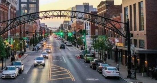


 SHORT NORTH
FRANKLINTON / HILLTOP
OLDE TOWNE EAST
LINDEN / MILO-GROGEN
KING-LINCOLN BRONZEVILLE
DISCOVERY DISTRICT
ARENA DISTRICT
SHORT NORTH
FRANKLINTON / HILLTOP
OLDE TOWNE EAST
LINDEN / MILO-GROGEN
KING-LINCOLN BRONZEVILLE
DISCOVERY DISTRICT
ARENA DISTRICT
DOWNTOWN COLUMBUS | THE CAPITAL LINE & CULTURAL PARK 90
GERMAN VILLAGE / MERION VILLAGE
 Arena District
Discovery District
Victorian Village Short North
Linden Milo-Grogen
King-Lincoln Bronzeville
Olde Towne East
German Village
Merion Village
Arena District
Discovery District
Victorian Village Short North
Linden Milo-Grogen
King-Lincoln Bronzeville
Olde Towne East
German Village
Merion Village
DOWNTOWN COLUMBUS | THE CAPITAL LINE & CULTURAL PARK 91
Franklinton Hilltop
RECONNECTING DOWNTOWN
THE
DOWNTOWN CORE A Transformative Experience
Columbus’ identity rests on the unique character of each of its neighborhoods. The same could be said for Downtown, as it begins to develop and take on a new form.
Gay Street Corridor: This neighborhood has the bones of a thriving retail street with pedestrian scaled architecture and a mixture of uses. With more activation on the ground, including new restaurants and retail planned for the district, these spaces can help create a destination for both daytime and nighttime crowds.
The Scioto Riverfront: Is the premier green space for both active and passive recreational activities. This linear open space connects downtown to parts east and west with pathways to the Arena District to the north and south to the Scioto Audubon Metro Park. In the future, we imagine the riverfront as the “Central Park” for Downtown as the center of activity for residents and visitors.
The Peninsula: Recent investments have transformed this land just west of COSI into a mixed-use district helping to connect new developments in Franklinton to Downtown. A mixture of apartments and condos increase density of the area with public art, new restaurants, bars and events to attract visitors.
River South: Gains its draw from recent investments in the Scioto Greenways and Scioto Mile public infrastructure projects. Offices and new residential opportunities help to anchor this space with Milestone 229, an outdoor amphitheater and newly reconstructed fountain.
4th & Main: This eclectic mix of retail, restaurants and eateries inhabits a series of pedestrian scaled brick facades along 4th Street within steps of the Columbus Commons. New residential opportunities with recent office conversions, as well as proposed projects such as The Estrella high-rise will continue to add energy.
4th & State: These future development parcels include the former Greyhound bus station, along with a collection of surface parking lots in close proximity to the Ohio Statehouse. The Columbus Association for the Performing Arts (CAPA) operates 4 thriving historical performing arts theaters, soon to add a 5th at the former Central Presbyterian Church, Ambry Music Hall.


 GAY STREET
& STATE
THE PENINSULA
4TH & MAIN 4TH
SCIOTO RIVERFRONT
DOWNTOWN COLUMBUS | THE CAPITAL LINE & CULTURAL PARK 92
RIVER SOUTH
 Gay Street
Scioto Riverfront
River South
4th & Main
4th & State
Gay Street
Scioto Riverfront
River South
4th & Main
4th & State
DOWNTOWN COLUMBUS | THE CAPITAL LINE & CULTURAL PARK 93
The Peninsula
Urban Trails Help Create Place
Invest in the Public Realm to Incentivize Private Development that will Infuse New Life Downtown with Destinational and Experiential Qualities


The Cultural Trail
INDIANAPOLIS, INDIANA
The Indianapolis Cultural Trail is a one-of-a-kind, multi-modal trail facility nested in an urban environment. Punctuated with contemporary public art, this project has become an international model for urban trail design and is a popular destination for residents and visitors. ICT has created a more connected and sustainable community in which to live, work, play and learn.
The Capital Line COLUMBUS, OHIO
The Capital Line has the opportunity to connect the most identifiable spaces within Downtown. Tying these spaces together with public art, placemaking components, and branding will help to build a more connected community. The Capital Line will establish a unique urban fabric for Columbus, and encourage a multi-modal exploration of Downtown that will enhance the pedestrian experience.
DOWNTOWN COLUMBUS | THE CAPITAL LINE & CULTURAL PARK 94 A SERIES OF
ROOMS
The Capital Line
This two-mile pedestrian and cyclist loop will help to redefine public space in downtown Columbus. For the first time in decades, a public infrastructure project will be implemented that will reduce reliance on the automobile and prioritize people on foot. In addition, this investment will add much needed green space in the heart of a number of growing residential districts within the city, helping to spark new investment opportunities and create a new identity for downtown.
Cultural Park (Scioto Riverfront)
The Peninsula
4th & State
Phase 1 Gay Street
The Commons 4th & Main South Stitch (River South)
THE BIG IDEA
DOWNTOWN COLUMBUS | THE CAPITAL LINE & CULTURAL PARK 95
A Revolutionary New Benchmark for 21st Century Urban Transportation and Public Space Design
Downtown Columbus has the opportunity to create a one-of-a-kind multi-modal system in the active core that not only connects other downtown districts, but the surrounding neighborhoods (i.e. German Village, King-Lincoln/Bronzeville, Short North, etc.). This ambitious and bold vision can become a dynamic icon for the City of Columbus that will transform a vehicular dominant space into an urban tapestry of pedestrian focused experiences enhancing the city’s quality of life for people.
Several case studies of recent urban trails from Atlanta to Indianapolis have proven the astonishing success of these infrastructural components in managing stormwater, catalyzing smart growth, revitalizing distressed properties and increasing economic investment that helps transform an aging city into trendy new mixed-use, mixed-income developments that greatly enhances pedestrian mobility through transit integration (i.e. LinkUS).
In the development of Phase 1, the implementation strategy for the Gay Street roadway improvements should consider a series of identifiable elements to develop a brand and essence of the trail to be established for future phases. These design elements should include, but are not limited to: iconic lighting elements, standard pavement patterns and markings, branded site furniture, established fonts and graphics for wayfinding with permanent and seasonal public art installations.


 LIGHTING ELEMENTS
SEATING & FURNISHINGS
PAVERS & PLANTINGS
FONTS & GRAPHICS
PAVEMENT MARKINGS
LIGHTING ELEMENTS
SEATING & FURNISHINGS
PAVERS & PLANTINGS
FONTS & GRAPHICS
PAVEMENT MARKINGS
DOWNTOWN COLUMBUS | THE CAPITAL LINE & CULTURAL PARK 96
ART ELEMENTS
THE CAPITAL LINE A UNIQUE URBAN TRAIL SYSTEM

DOWNTOWN COLUMBUS | THE CAPITAL LINE & CULTURAL PARK 97
BRIDGE & WEDGE OPTIONS AND COST ANALYSIS
JANUARY 24, 2024
DOWNTOWN COLUMBUS | THE CAPITAL LINE & CULTURAL PARK 98

DOWNTOWN COLUMBUS | THE CAPITAL LINE & CULTURAL PARK 99

DOWNTOWN COLUMBUS | THE CAPITAL LINE & CULTURAL PARK 100 BRIDGE OPTION 01

DOWNTOWN COLUMBUS | THE CAPITAL LINE & CULTURAL PARK 101

DOWNTOWN COLUMBUS | THE CAPITAL LINE & CULTURAL PARK 102 BRIDGE OPTION 02

DOWNTOWN COLUMBUS | THE CAPITAL LINE & CULTURAL PARK 103

DOWNTOWN COLUMBUS | THE CAPITAL LINE & CULTURAL PARK 104 BRIDGE OPTION 03

DOWNTOWN COLUMBUS | THE CAPITAL LINE & CULTURAL PARK 105

DOWNTOWN COLUMBUS | THE CAPITAL LINE & CULTURAL PARK 106 WEDGE OPTION 01

DOWNTOWN COLUMBUS | THE CAPITAL LINE & CULTURAL PARK 107

DOWNTOWN COLUMBUS | THE CAPITAL LINE & CULTURAL PARK 108 WEDGE OPTION 02
DOWNTOWN COLUMBUS | THE CAPITAL LINE & CULTURAL PARK 109
CONTINUED WEDGE OPTIONS AND COST ANALYSIS
FEBRUARY 14, 2024
DOWNTOWN COLUMBUS | THE CAPITAL LINE & CULTURAL PARK 110

DOWNTOWN COLUMBUS | THE CAPITAL LINE & CULTURAL PARK 111

DOWNTOWN COLUMBUS | THE CAPITAL LINE & CULTURAL PARK 112 01 IMPROVED SIDEWALK

DOWNTOWN COLUMBUS | THE CAPITAL LINE & CULTURAL PARK 113

DOWNTOWN COLUMBUS | THE CAPITAL LINE & CULTURAL PARK 114 02 PEDESTRIAN
BRIDGE
DOWNTOWN COLUMBUS | THE CAPITAL LINE & CULTURAL PARK 115

DOWNTOWN COLUMBUS | THE CAPITAL LINE & CULTURAL PARK 116 03 WEDGE A
DOWNTOWN COLUMBUS | THE CAPITAL LINE & CULTURAL PARK 117
DOWNTOWN COLUMBUS | THE CAPITAL LINE & CULTURAL PARK 118 03 WEDGE A
DOWNTOWN COLUMBUS | THE CAPITAL LINE & CULTURAL PARK 119
BRIDGE FEASIBILITY ANALYSIS
PRELIMINARY BRIDGE ANALSYIS
The existing Broad Street Bridge was originally constructed in 1992 and provides connectivity for highway route US-40/62 over the Scioto River in Downtown Columbus, OH. The multi-span, river crossing is comprised of three post-tensioned reinforced concrete arch girders on reinforced concrete abutments with driven/battered pile foundations and reinforced concrete piers supported on drilled shafts. All substructure elements are skewed 30° to match the natural flow direction of the Scioto River.

ELEVATION VIEW – EXISTING BRIDGE
The concrete arch girders support a reinforced concrete deck with a 2” integral micro-silica modified concrete wearing surface, which was most recently replaced in 2008. The structural deck is comprised of a network of draped transverse ducts that contain multiple post-tensioned steel strands and are spaced at 21” along the length of the deck. In its current condition, the bridge supports a 90’ vehicular travel way, 13’6” walks on each side, and wider balconies at all pier ends to provide pedestrians with river overlooks. Beneath the cantilevered portions of the deck are top mounted utility banks that support up to 33 individual conduits each and provide service to facilities on either side of the river.

TRANSVERSE SECTION (MILD STEEL NOT SHOWN)
As a part of the conceptual bridge study, EMH&T was tasked with determining an anticipated load allowance for the existing bridge to provide REALM with a baseline for the proposed architectural enhancements. The following sections will discuss in more detail the methods, assumptions, and analysis completed to determine this load threshold to ensure existing elements are not overstressed in the enhanced condition.
DESIGN LOADING
As indicated in the original 1990 Construction Plans (FRA-40-12.26), the existing bridge was designed for HS25-44 vehicular loading per AASHTO’s Standard Specifications for Highway Bridges (archived 1989) The vehicular live load demand depicted in the design specification for a single loaded lane is the worst of either a 45-ton truck, 25-ton tandem (denoted as the Alternate Military Load), or a lane load consisting of an 80 psf distributed load and 11 to 16-ton axles located to create the worst load effect on the bridge. These moving loads were modeled over a 10’ width to determine the controlling live load effect and equate them to an equivalent distributed load allowance within a single lane. Additional factors such as dynamic load effects, multiple presence factors, and sidewalk loading are considered in these equivalent loads. As the deck and beams are a post tensioned system and designed for service (unfactored) conditions, load recharacterization (i.e. from Live to
Dead) do not provide any additional allowance without resulting in potential overstressing of the post tensioned members and have been conservatively ignored.
It’s also worth noting that ODOTs current bridge inventory for this structure (SFN: 2502577) shows an inventory rating of 1.40, suggesting that an additional 40% of live load allowance is available before the design capacity of the superstructure is anticipated to be exceeded.
Our analysis assumes the following:
• The dead load allowance is primarily based on the displaced travel way and does not account for any weight saving modifications that may occur in the proposed condition
• All structural elements including: post-tensioning, reinforcing steel, and concrete are assumed to be undeteriorated and meet the minimum material strengths specified in the record plans
• The minimum number of lanes will not be less than 4 to ensure consistent multiple presence factors and acceptable drainage requirements
• Seismic and other lateral load effects have been ignored as a part of these preliminary efforts
ANALYSIS RESULTS
To simplify preliminary analysis, the live load effects were modeled over a longitudinal continuous beam to investigate the behavior independent of skew, number of loaded lanes, and/or live load distribution factors. From these results, equivalent distributed loads were determined that resolve into maximum forces mimicking the moving load analysis. As these results are calculated about the width of the lane, the equivalent pressures assume that an equal width of travel way is displaced (removed from vehicular access) that can then be modified in an equivalent width elsewhere on the deck. A preliminary post tension beam design check was then completed which determined that additional capacity is likely available within the exterior beam as suggested by the most recent load rating.
A transverse section of the bridge was than modeled to determine the maximum live load effects on the post tensioned deck. This analysis applied wheel loads within each lane and distributed them over an equivalent width of the post tensioned deck. Applicable lanes were then removed from the vehicular travel way and replaced with equivalent pressures to determine the maximum patch load that could be applied to the deck before it exceeded the worst-case transverse vehicular load condition.
Lastly, the live load reactions provided within the record plans were compared against all anticipated load conditions to ensure the supports would not exceed the original intended loading. It was not initially clear if the original bridge was designed to float a vehicle beyond the curb line, but after reviewing the live load reactions provided in the record plans it appears the ratio of the exterior bearing reactions vs the interior reactions is comparable to the ratio of the tributary width relative the exterior vs interior girders (including overhangs). This seems to indicate that the live load demand is based on a wider travel way than what is possible in the existing curbed condition – supporting the application of an equivalent lane pressure through the limits of the existing walk. In comparing these reactions against the anticipated pressures from the longitudinal and transverse analysis, it was determined that the support reactions at the bearing will likely control these equivalent pressures. It should be noted that all drilled shafts appear to be designed for the interior (most heavily loaded) condition, suggesting that additional capacity loading could be supported if exterior bearings were rehabilitated/replaced.
The results of the longitudinal analysis are provided in Figure 1 below and depict the maximum live load force effects that can be anticipated within a single 10’ lane. As indicted in these figures, any load condition that results in a value within the base condition (shown in red) would be considered acceptable from an equivalent force effect.
Based on these results we have determined three alternative load conditions that could be applied to the existing bridge that would not likely exceed the live load demand of the existing structure:
• Condition A (Full Uniform): 160 psf uniform load limit. This equates to 15” planter beds or 8” of soil with concurrent 75 psf pedestrian load.
• Condition B (Partial Distributed Loads): 250 psf over piers with a 75 psf pedestrian load applied everywhere else. A 250 psf load equates to 24” planter beds or 16” of soil with concurrent 75 psf pedestrian load.
• Condition C (Concentrated Point Loads): 75 psf pedestrian load + 4000 lb/ft line loads around the piers to accommodate larger isolated planters
1 12.01.2023 |
DOWNTOWN COLUMBUS | THE CAPITAL LINE & CULTURAL PARK 120
BROAD STREET BRIDGE STUDY
BRIDGE FEASIBILITY ANALYSIS
OTHER CONSIDERATIONS


Option C (concentrated point loads) contemplates the installation of kiosks on the bridge deck. It is assumed these kiosks would entail food service, and therefore would necessitate the extension of utility services to the kiosk. Utility service extensions would at minimum included electrical power, potable water, and sanitary waste lines (assumption is no gas, and comm/telephone can be wireless). The utility service lines would need to either: a) run across the bridge deck and be integrated within the landscape planter beds; or b) penetrate through the bridge deck and run with the girders under the deck. In either scenario the potable water lines would need to heat-traced for a year round operation, or the potable water lines would need to be winterized for a three season operation.
Another consideration to note is that the traffic lanes on the bridge will need to taper transition beyond the limits of the bridge, between Belle Street and Front Street.
CONCLUSION
The preliminary calculations provided within this conceptual study are intended for planning purposes only to facilitate discussion and provide an idea of the level of enhancements that could be applied to the existing bridge before rehabilitation would be necessary. As such, any enhancements that would be applied to the existing bridge would need to undergo a thorough structural evaluation to confirm the influence of the applied enhancements and ensure final load carrying capacity.
As stated earlier, the bridge was constructed per AASHTO’s archived Standard Specifications for Highway Bridges and equivalent loads have been provided based on the original design vehicle. It is our assumption that any modifications proposed would not result in a revised load analysis that would require modern HL-93 vehicle loading – which includes a 36-ton truck with a concurrent 64 psf distributed lane load
The loading suggested is based on the displaced travel way and therefore enhancements would need to reduce the current lane widths to activate the additional loads In all scenarios, a minimum 75 psf pedestrian load should be accommodated where pedestrian access is not restricted by planters or features that would prevent such movement As the deck contains several post-tensioning strands, coring or doweling into the structural slab is not recommended - rather horizontal anchorages into the existing sidewalk and/or scarification of the top deck surface should be considered to accommodate any potential walk or planter installations.
The existing bridge is located within a vertical curve and does not support drainage scuppers. Outside striped bicycle lanes appear to provide adequate width to contain any stormwater spread that could potentially impede vehicular travel during a design rainfall event. In the improved condition, sufficient shoulder width should be provided to accommodate this spread. The pedestrian facilities are located on raised concrete walks and protected by 12” integral curbs. Any modifications within lanes should account for pedestrian protection relative the travel way as well as any necessary barriers to protect errant vehicles from proposed features.
As the bridge is owned and operated jointly by multiple state and federal agencies (ODOT, Franklin County, City of Columbus, FHWA) any improvements would need approval and coordinated with the invested stakeholders to ensure the following: enhancements do not result in unintended impacts to the travelling public, cause detriment to the lifecycle of the system, accommodate routine inspection/maintenance, and conform to the master plan of the community. A previous feasibility study was performed with the original ’92 Broad Street Bridge Replacement and should also be recognized for potential coordination with applicable planning committees.
ADJACENT STRUCTURE
As a part of the conceptual study an adjacent wedge type structure is proposed to provide additional pedestrian connectivity to the Broad Street Bridge. This structure would be constructed separately from the existing bridge and would be entirely self-supporting. The two structures would be separated by a parallel and traversable expansion joint to ensure no load transfer to the existing bridge. This wedge feature would be designed to support pedestrian only live loads with the desired architectural enhancements including but not limited to: pavers, plantings/green roof systems, and small kiosk or single story lightly framed building – similar to equivalent uniform load demands suggested in prior sections. As this alternative requires additional pier supports, abutments and columns would be constructed in the hydraulic projection to avoid changes to the FEMA flood model.
Various framing alternatives may exist to reduce the overall impact of the proposed wedge. The proposed Alternative A depicted in the conceptual study costs assume an 85’-55’ two span structure with a tapered deck and variable depth superstructure elements closely resembling the existing arch profiles. This alternative requires the end 55’ span to be entirely cantilevered as to eliminate an additional pier being located outside of the current hydraulic projection. As this option requires a very large cantilever, deep, post tensioned, superstructure, elements would be required to achieve acceptable structural capacity and deflection criteria. Additional counterweights at the abutment may
DOWNTOWN COLUMBUS | THE CAPITAL LINE & CULTURAL PARK 121
2 | 12.01.2023 | BROAD STREET BRIDGE STUDY
FIGURE 1 – EQUIVLENT FORCE DIAGRAMS (LONGITUDINAL LANE ANALYSIS)
BRIDGE FEASIBILITY ANALYSIS
be required to provide further structural stability for the fully loaded cantilever. This option is considered the most expensive and structurally complex alternative of the two considered. Further structural evaluation would need completed for this alternative to justify the viability of this option and the supporting features.
Alternative B, considers an additional pier support outside of the existing hydraulic projection to eliminate the cantilever, utilize a shallower superstructure, and simplify overall framing. This option would locate a pier outside of the existing hydraulic projection and require adjustments to the current FEMA model – necessitating much further environmental coordination. This option is structurally more feasible as it eliminates significant force effects and challenges associated with the large cantilever.
PERMITTING AND OTHER CONSIDERATIONS
Alternative A
The modifications to the existing Broad Street bridge, as well as the addition of the wedge structure will require a Drawer E permit plan through the City of Columbus. An E plan scope of improvements will first need to be developed and issued by the Columbus Department of Public Service (DPS). The design development can begin only after DPS issues the scope of improvements. The Drawer E plan development process requires three staged submissions plus backcheck submissions. This process, from scoping to plan approval, typically takes approximately 18 months to complete.
Improvements within the 100-year floodplain will result from the wedge bride. As a result, a No Rise certification will need to be obtain from FEMA. This process entails the development of a flood plain model to verify that there is a no rise condition at all adjacent structures and lettered cross sections resulting from the proposed bridge (fill) within the floodplain. This process typically takes 12-18 months to complete, and will be concurrent with the development of the Drawer E plans.
It is assumed that all bridge work will be done from the banks, as opposed to work within the Scioto River. Therefore, a waterways permit through the Army Corp of Engineers is not anticipated. However, should this approach change, obtaining a Nationwide Permit through the Army Corp of Engineers for work within the waterway typically takes 6-12 months to obtain, and can be done concurrent with the plan design.
Following completion of the design development process, privately owned utilities conflicting with the proposed improvements will need to relocated before the construction of the wedge structure can proceed. It is customary to allow 6 to 12 months for utility relocation. Once utilities are relocation, the bidding and construction of the bridge improvements may proceed. Bidding and contracting is estimated to take 3-4 months. And construction is estimated to take approximately 2 years to complete. Therefore, the entire project process from scoping through construction completion is estimated to take 4 to 5 years.
Alternative B
The Drawer E permitting requirements and timelines as noted above would apply to Alternative B. In addition to these, the following additional permitting requirement would result from Alternative B:
• In this Alternative, it is anticipated that a No Rise Certificate will not be achievable due to the inclusion of new bridge pier(s) within the flood plain. Therefore, a Conditional Letter of Map Revision (CLOMR) through FEMA will result. This process typically takeS around two years to complete, but can take longer depending upon the number and duration of reviews by FEMA. Additionally, a Letter of Map Revision (LOMR) will also need to filed at the completion of construction to document the as-built conditions.
• The additional pier line is also close to the Ohio EPA environmental covenant. As long as the pier remains outside of the environmental covenant, no issues with the EPA are anticipated. However, if the pier location moves into the environmental covenant during the design development, negotiations with the EPA for an exception would need to proceed this, as the Covenant does not permit the installation of bridge piers.
The total project duration for Alternative B, from planning/scoping to the filling of the LOMR is expected to take 6-7 years.
Additional Considerations
One additional consideration worth noting is the architectural aesthetics of the existing Broad Street bridge was a result of a very thorough, detailed, and well documented public involvement process. This process produced extensive public input into the functionality and aesthetics of the current bridge due to the civic and historic prominence of the bridge. Given the heightened public interest in this bridge, along with the prior public involvement process, an extensive public outreach should be consider during the planning and design stages of the project.
DOWNTOWN COLUMBUS | THE CAPITAL LINE & CULTURAL PARK 122
12.01.2023 | BROAD STREET BRIDGE STUDY
3


DOWNTOWN COLUMBUS | THE CAPITAL LINE & CULTURAL PARK 123
FEASIBILITY ANALYSIS BROAD STREET BRIDGEWEDGE FRAMING EXHIBIT BROAD STREET BRIDGE STUDY
‘THE WEDGE’
Public Realm Designer
100 east broad street, suite 1710 columbus, ohio 43215
614.670.7390
www.realmcollaborative.com

Structural Engineering
5500 new albany road columbus, ohio 43054
614.775.4500
www.emht.com

Downtown Columbus Inc.
150 south front street, suite 210 columbus, ohio 43215
614.545.4700
www.downtowncolumbus.com
