

CASTLE
VOLUME
ISSUE 03 SEPTEMBER 2018
RABY
AND PARK
ONE: CONSERVATION PLAN
Rebecca
Burrows, Dr Alex Holton and Bev Kerr
On behalf of Purcell ®
29 Marygate, York YO30 7WH www.purcelluk.com
Purcell asserts its moral rights to be identified as the author of this work under the Copyright, Designs and Patents Act 1988.
Purcell grants the Raby Estate a non-exclusive licence to make use of the Report providing this is consistent with the purpose for which the Report was commissioned and that Purcell remain acknowledged as the author and intellectual property holder as part of any such use, in whole or in part. Purcell has no liability for use of the Report for any purpose other than that for which it was originally prepared and produced.
The Raby Estate retains copyright of all materials provided to Purcell in the production of the Report, including maps, plans and photographs. Purcell retains a licence from the Raby Estate to use and reproduce these materials within the Report.
Purcell® is the trading name of Purcell Miller Tritton LLP
Issue 01 June 2018
Lord and Lady Barnard Issue 02 July 2018 Lord and Lady Barnard Issue 03 September 2018 Lord and Lady Barnard
001_238974
RABY CASTLE AND PARK: CONSERVATION PLAN CONTENTS
EXECUTIVE SUMMARY 0 4
PART ONE: THE RABY CASTLE ESTATE
1.0 PRELIMINARIES 07
1.1 Vision of The Raby Estate 07
1.2 Purpose of the Report 07
1.3 Identifying the Site 07
1.4 Methodology 08
1.5 Research and Findings 09
1.6 Consultation, Adoption and Review 09
1.7 Authorship and Acknowledgements 09
1.8 Navigating the Document 09
2.0 UNDERSTANDING RABY PARK 10
2.1 Site Location 10
2.2 Topography and Geology 11
2.3 Ownership, Management and Use 11
2.4 Heritage Protection and Designations 13
2.5 Overall Condition 15
2.6 Character Areas 16
2.7 Built Heritage Components 17
2.8 Setting and Key Views 28
2.9 L andscape 35
2.10 Archaeological Potential 41
2.11 Location of Old Raby 43
3.0 U NDERSTANDING H ISTORICAL D EVELOPMENT 45 3.1 Introduction 45 3.2 Raby Castle, Park Estate and Gardens Timeline 45 3.3 Map Progression 63 3.4 Relationship of Landscape to Structures 78 3.5 Historic Route Analysis 82 3.6 Phases of Development 84 3.7 Historic Uses and Functions 85 3.8 Contextual Analysis 87
4.0 ASSESSMENT OF SIGNIFICANCE 96 4.1 Criteria for Assessment 96 4.2 Assessment of Significance 96 4.3 Significance Plans 101
PART TWO: CONSERVATION FRAMEWORK
5.0 ISSUES AND VULNERABILITIES 105 5.1 Raby Castle and Wider Landscape 105 5.2 Walled Garden and Stables 106
6.0 PRINCIPLES AND RECOMMENDATIONS 107 6.1 Raby Park: Principles for Conservation and Change 107 6.2 Recommended Actions by Theme 108 6.3 Raby Park: Emerging Research Framework 112 6.4 Archaeological Strategy 116 6.5 Recommended Actions by Area 118
7.0 CAPACITY F OR CHANGE 121 7.1 Introduction 121 7.2 Capacity for Change 121
BIBLIOGRAPHY 127
APPENDICES
A: List Descriptions 147
B: Historic Parks and Gardens Register 152 C: Relevant Planning Policy 154
8.0 N EXT STEPS 126 8.1 Adoption and Review 126 8.2 Phasing and Implementation 126
Contents
EXECUTIVE SUMMARY
VISION
The Raby Estate is forward looking in its vision for a sustainable future for the Grade I listed Raby Castle and its surrounding Registered landscape. Lord Barnard aims to create a viable, outward facing offer for visitors through a shared understanding, a passion for the Estate’s rich history, a safeguarded natural and historic environment, strong community ties and access for new audiences.
This Conservation Plan is the first step in supporting the vision of the Estate to conserve and bring relevance back to the nationally significant heritage assets and their setting by providing a high-quality offer to visitors in a way that conserves significance and does not dilute authenticity. The document and its associated gazetteer provides a baseline of evidence for future decisionmaking. It sets out an assessment of significance, vulnerabilities that could harm this and recommended actions to support informed management and change.
The Conservation Plan has focused its emphasis on those areas likely to be areas of development in the future. The Walled Gardens and stables area has been assessed in detail, with consideration of its setting within a Registered deer park and associated historic structures. The Castle is the principal heritage asset within the landscape and while it has been assessed in relation to surroundings, it has not yet been subject to detailed analysis. Thorough analysis of the Castle will be required at the necessary stage, if proposals for change are put forward.
SIGNIFICANCE
Raby Castle is one of the most significant and intact medieval Castles in the North East, set within a complete eighteenth-century deer park landscape and agricultural estate spanning much of Teesdale. Raby has earlier origins as a Viking settlement of King Cnut, known as ‘Rabi’ in the 11th century. The Nevill family built the current structure in the fourteenth century (1367-90) and along with Brancepeth Castle, Raby Castle is part of wider development of quadrangular castles of this period in the region, built by rich and powerful families in the border region where the power of the king was weak. Along with Barnard Castle, Raby Castle is also significant as one of most substantial fortification sites in the county. Its completeness is of national significance, as a largely single-phase structure, with one twelfth century survival (Bulmer’s Tower) and later eighteenth and nineteenth century infill and additions. Associations with masons and architects such as John Lewyn (Durham Cathedral), William Burn, John Carr, David Garrett and James Paine are important and the fact that no archaeological investigations have ever been carried out here is of high evidential value.01
Raby Castle gives the impression of a medieval fortress on to which a rich nineteenth century Jacobethan scheme has been applied, punctuated by fashionable Gothick additions in the eighteenth century, which have historically been overlooked. Originally moated and accessed via a drawbridge, the Castle was built as a palace fortress and as a symbol of hegemony. It is characterised by a sequence of massive towers linked by curtain walls, crowned with crenelated parapets and machicolations, illustrating chivalric lordship through its heavily militarised aspect.02 Extensive repairs and alterations in the mid to late-eighteenth century were carried out by renowned architects, creating Palladian and Rococo Gothic rooms, followed by a comprehensive mid-nineteenth century scheme by William Burn.
Following the Nevills’ unsuccessful the Rising of the North in 1569, Raby Castle has been the home of the Vane family since 1626 and is characterised by its undulating parkland, and collections of art and artefacts. The medieval deer park associated with Raby Castle is an example of the 3000 deer park surviving nationally, and illustrates the activity of medieval nobility, which continue to have a powerful influence on English landscapes today. The landscaped parkland of the mid-eighteenth century visible at Raby Castle today is Registered as a park and garden of special interest and was reworked several times within the eighteenth century, in a pattern seen across the region. Garret, Paine, Carr, Robinson (Auckland Castle) and Joseph Spence all had an input into the design that has survived remarkably intact into the twenty-first century.
The Walled Gardens and stables at Raby Castle are of interest for their close visual and functional relationship with the Castle. Early examples of walled gardens from the seventeenth or early eighteenth century could be areas of conspicuous display and highly visible, such as those at Auckland Castle, however as these became more common in the late eighteenth to early nineteenth century they were generally laid out away from the main house.03 At Raby Castle, the gardens remained visually dominant within the landscape, as although there were no connections from principal rooms within the Castle (which all face south), the principal view of the south elevation across the lakes also draws in the gently sloping walled gardens and stables. The reason for this location may have been a continuing matter of display, showcasing exotic plants, but was also a practical response to the evolution of the location of the medieval village of Old Raby and its field systems.
Taken as an ensemble, the Walled Gardens and stables are significant as an intact and well-organised area, formally developed in a short period to serve the evolving needs of the Castle. It incorporates the household supply of vegetables, fruit and flowers (tied to display of prestigious horticultural skills), the accommodation of expensive hunting and carriage horses (which in itself was an area of display and a newly-evolving fashion with associated design innovations) and the ancillary functions to service the Castle including meat, dairy, joiners, masons, gardeners and farrier. The formalisation of these services as part of the clear intent to move the old village away from the Castle is of interest and fits into a pattern of landscape change seen nationally. The functional and formal relationship of the walled garden area within the setting of the Castle is highly significant and is relatively rare in terms of visibility, if not function.
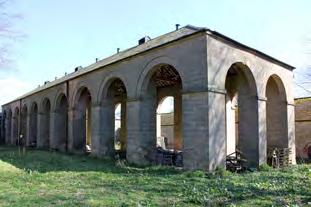
O ther structures within the landscape are typical features constructed as part of an eighteenth century landscaped park, including bath houses, ice houses, follies, temples and model farms. The Riding School is a rare building type, one of only 14 known examples from the peak of construction in the late eighteenth and early nineteenth century.04 The grand architectural statement of the hay barn is also an unusual and early example of an agricultural building. Home farm, which is outside the Registered parkland, is a notable early example (mid-eighteenth century with earlier origins) of one of a few model farms in the county.05
01 Shared Visions: The North-East Regional Research Framework for the Historic Environment, David Petts with Christopher Gerrard, 20 06
02 Shaping the Nation: England 1360-1461, G L Harris, 2005
03 https://content.historicengland.org.uk/images-books/publications/ dlsg-garden-park-structures/heag108-garden-and-park-structureslsg.pdf
04 G Worsley, The British Stable, 2004
05 Shared Visions: The North-East Regional Research Framework for the Historic Environment, David Petts with Christopher Gerrard, 20 06
04
Contents
A s a group, the medieval Castle, Registered parkland and Walled Garden area form a highly significant group for their evidential, historical and aesthetic value. Each structure informs an understanding of its surroundings and should not be read in isolation. The landscaped park within which each structure is set is also significant, with historic routes, tree planting, designed views and ancient features all contributing to an understanding of how the Estate was used in the past. Visual and intangible connections between the Walled Gardens, Bath Wood, lakes, stables, Raff Yard and the Castle are important although some designed views and planting schemes have been lost.
F INDINGS
The conservation planning process has led to an increased understanding of the Estate. Cartographical analysis of the Raby Castle archives has provided greater clarity of dates, uses, locations, associations and significance, providing more accuracy than the designation descriptions. The archaeological potential of Raby Castle and its Registered landscape is extremely high as no archaeological investigations have been carried out and minor finds range from Neolithic to Roman and Danish phases of occupation. The assumed location of the medieval village of Raby requires verification, which could form a truly exciting and inclusive community event with non-intrusive surveys and possible excavations if development is proposed.
The Estate is well managed and maintained by the owners and the principal structures within the Registered deer park are in good overall condition. Those buildings in use within the Walled Gardens and stables area are in good condition although those in a low-level use or redundancy are declining in condition and require maintenance. The landscape itself is well managed but there remains a need to balance land management regimes with biodiversity. Loss of parkland trees has reduced aesthetic value and some newer clumps require improvement.
Current barriers to increased visitor numbers relate to a need to resolve access, interpretation, circulation, facilities and activities. The Castle is the principal draw on the Estate, but a refresh of interpretation and marketing would be beneficial. The Walled Gardens as a visitor attraction are supported by visitor facilities in the stables including a shop and tea room. Improvements to the stables area would include new, high-quality offers, physical alterations to allow inclusive access, new routes across the landscape and improved vehicular access to deal with increasing traffic.
The Walled Gardens and stables area contains a number of important designated heritage assets but is also underutilised and at risk of decline. Each structure on the site is capable of beneficial reuse and could be subject to informed change dependent on significance. The capacity and constraints on change for each structure is linked to their heritage value, the degree of past alteration, relationship to the Castle and setting, and the viability of accommodating a new use. Each component has been addressed in turn within the gazetteer. The character of this area is one of formality and functionality, which permeates from south to north as historic use changes. The polite and vernacular features of these structures will need to be sustained and enhanced as part of any regeneration. Heritage significance naturally increases the need to utilise highquality craftsmanship, materials and design, which will impact on the conservation deficit of these structures and the viability of a scheme for revenue generation.
Future development within Raby Estates will be grounded within a robust understanding of significance, outlined in this framework document and supported by additional targeted investigations if required. Any conflict will be identified and resolved, and the impact of proposed changes will be assessed as part of an iterative masterplanning and design process. Recognition, understanding and sensitivity to the value of the significance of the Estate will allow the vision of the owner to be realised in a way that is sustainable into the future.
05 EXECUTIVE SUMMARY
Contents

06 PART ONE RABY CASTLE AND PARK 1.0 Preliminaries 07 2.0 Understanding Raby Park 10 3.0 Understanding Historical Development 45 4.0 Assessment of Significance 96 Contents
PRELIMINARIES
1.1 V ISION OF THE RABY ESTATE
Lord and Lady Barnard and Raby Estates value the authenticity of Raby Castle and its surrounding parkland and wider landscapes. They see themselves as custodians for the family, the estate and its history, and aim to continue to care for these in a sustainable way in the future. The vision of the Estate is to create a viable, outward facing offer for visitors through a shared understanding, passion for their rich history, safeguarding the environment, strengthening the community and its economy, and seeking new and proactive ways of doing business. There is a commitment to trust, quality and good service.
The Raby Estate is now at a turning point in its history. The extensive assets and opportunities represented by the site are not currently utilised to their best advantage. Historic buildings with the potential to be put to viable new uses are underutilised and beginning to deteriorate. The aim of the Estate is to conserve and bring relevance back to these nationally significant structures by providing a high-quality offer to visitors, in a way that does not dilute the authenticity of the site as a working Estate and family home. Changes that make the Castle and Park more accessible and open to new audiences will be welcomed. Many local people have lived within view of the Castle all their lives but have never been inside. Activities that reflect the personalities of the owners will be of the highest importance.
In the wider view, the full Raby Estate provides opportunities that connect to the use of the Castle, Park and stables area. Leisure uses such as High Force, the Pennine Way and old railway lines all provide a network of links and routes that could increase footfall. Vacant farmsteads across the landscape provide opportunities for wider uses from accommodation to storage and maintenance in a way that will freeup more significant and usable spaces within the immediate setting of the Castle.
This Conservation Plan represents the first step towards an understanding of the Castle, Park and stables, and will provide a baseline of evidence for future decision-making. Lord and Lady Barnard are conducting masterplanning, business planning and marketing activities to enhance the sustainability of the Estate. A visioning activity has been undertaken in June 2018 with key stakeholders such as Visit County Durham and Durham County Council (DCC) and the condition survey for the site was undertaken in May 2018.01 An assessment of the retail and visitor offer has been carried out, all with the aim of making Raby Estates more accessible and outward facing.
The Raby Estate is well supported by statutory bodies and stakeholders in the region. DCC are committed to ensuring Raby Castle becomes a key player in the tourism and wider visitor economy of Country Durham. The Estate is a strategic priority for DCC as part of their wider commitment to increasing dwell time in the area. There is an opportunity to support the repair and conservation of the heritage assets across the Estate in a sustainable way that provides a viable new offer to visitors both locally and nationally. The vacant and underused structures within the Walled Gardens and stables area and wider within the Parkland offer high-quality and characterful spaces for new uses as listed buildings in their own right, but also set against the backdrop of the stunning Castle.
The future for Raby Estate is not one that can be rushed. An award-winning visitor offer will need careful planning, centred around a clear vision for what it wants to achieve. The strong connections and communities that will be forged during this development process will be important. The aim is to produce an inclusive visitor facility for diverse audiences centred on the offer of the Castle, which is timeless but high-quality, relaxed and uplifting, flexible, family-friendly and engaging. The Castle will offer an authentic historic experience, the Parkland will provide wide, open spaces and the gardens will provide peace
01 Quinquennial Inspection, Donald Insall, May 2018 and visioning workshops in May and June 2018, facilitated by Blue Sail
and tranquillity. Overall, the site will be enticing and will seek to enhance the existing authenticity of the place, building on these qualities rather than imposing upon them.
1.2 P URPOSE OF THE REPORT
This Conservation Plan is intended to be a strategic report contributing to the successful future management and use of the Registered Park and Garden known as Raby Park within Raby Estates and will provide baseline information to contribute to an overall understanding of the significance and vulnerabilities of the place, relationships between assets, as well as highlighting areas where appropriate change could be made.
In line with the original client brief (30th January 2018) this Conservation Plan has concentrated its emphasis on those areas within Raby Park that are likely to be the focus of development and change in the future. The Gazetteer (Volume Two) of this Conservation Plan has an emphasis on the stables and Walled Garden area to the north of the Castle. While it is recognised that the Castle is the most significant asset within the Park, this is unlikely to be subject to major alteration and as such has only been assessed in its relation to its setting and other heritage assets within the Park.
As defined in the project brief, the objectives of this Conservation Plan are:
i to use all relevant accessible primary, secondary and tertiary sources of evidence and research concerning the defined heritage assets to set out the significance of the site;
ii present an overall breakdown of the values of each heritage asset, internal and external, focussing on archaeological, architectural, artist or historic interest;
iii to present a comprehensive overall assessment of the relative vulnerability of each asset and the whole;
iv to identify each aspect of the `special interest' of the asset, which may have a particular vulnerability, as informed by the above;
v to identify the limits of acceptable change to each asset, the site and its fixtures including explaining why they are vulnerable and to what extent or nature; provide general mitigation alternatives and identify any unresolved issues or gaps in knowledge; and,
vi to provide a basis for developing options for the future use, adaptation and care of the buildings, gardens, spaces and parkland in the immediate future and long-term, 10 years on.
1 .3 I DENTIFYING THE SITE
This Conservation Plan relates to the landscape and structures contained within the Registered Park and Garden of Raby Castle (Grade II*), and a small extension to encompass the Laundry to the north-west. Some components beyond this boundary will be discussed due to the current and historic relationships they hold to other elements within the Registered area. For clarity, references to the full extent of the estate will be referred to as Raby Estates, as will the client body. The physical structure of the castle will be referred to as Raby Castle. The study site for this Conservation Plan will be referred to as Raby Park when considering the full Registered area, or the Walled Gardens and stables when focusing on this smaller element. The definition ‘Raby Park’ is one that exists only for the purposes of this report.
07 SECTION 1.0
Contents
1.4 METHODOLOGY
A Conservation Plan is a document that aims to guide the future development and conservation of a heritage asset by setting out a framework for its management and maintenance in a series of policies which recognise the issues the building may face and also the opportunities where its heritage value can be enhanced. These recommendations, discussed in Section 6, are informed by the understanding and significance sections that come earlier on in the document.
The Conservation Plan will provide a resource for understanding the history, significance and potential for change at Raby Castle and Park. The principal sections of the Plan will encompass:
• Volume One, beginning with a background Understanding of the site and its setting; where it is and what it comprises. This section will also detail the relevant statutory designation applicable to the site, how it is used, and also character areas, key views, condition and archaeological potential.
• The Historical Development of the Park, Walled Gardens, and the stables area is summarised and set against the backdrop of the wider history of Raby Castle. This section brings together estate plans from Raby’s own archives as well as Ordnance Survey maps of the site to show the historical progression over the past three centuries, focusing on the Walled Gardens, and the Stable are.
• An Assessment Of Significance which will explain why and to what extent the site is important and valued, both culturally and with regards to its heritage. It is set within its national context.
• The Conservation Framework will provide as assessment of the issues as well as opportunities to enhance heritage value at Raby Castle and Park. This will include an analysis of the potential of the site for future change and recommedations to guide potential change in a sensitive and conservation-led approach.
• Volume Two contains a detailed Gazetteer of the wider Estate landscape areas and structures, and the Walled Garden and stables character areas and structures. Information on significance, historic development, issues, opportunities and potential are included.
08 PRELIMINARIES
MANAGEMENT GAZETTEERS CMP ANALYSIS FRAMEWORK Current Situation EVALUATION Past Evolution Challenges and Opportunities Significance Capacity and Parameters Landscape Character Areas Walled Gardens and Stables Character Areas Walled Gardens and Stables Character Areas Estate Structures Principles and Policies Action Plan VOLUME ONE VOLUME TWO Contents
1.5 R ESEARCH AND FINDINGS
An emerging research framework has been produced as part of this Conservation Plan to aid future research into specific details or components. This can be found in Section 6.3 Resources used, findings and any gaps in knowledge have been articulated here. The bibliography on page 127 sets out the sources used to inform understanding. Unless otherwise stated, all historic maps and plans are taken from the Raby Castle archives and remain the copyright of Raby Estates. Reproduction may only be carried out with thier express permission. Unless otherwise stated, photographs within the report are copyright Purcell.
1.6 C ONSULTATION, ADOPTION AND REVIEW
Internal and external consultation and advice on the content and direction of this Conservation Plan has been sought along two related strands of engagement. The first involved a series of client meetings together with frequent liaison with Durham County Council (also present at client meetings, site reviews and briefings) and Historic England (who were also provided with the original client brief for reference). A site visit was also carried out separately by Historic England to inform and assist the process. Feedback and steer arising from these activities was drawn upon to continually inform the plan’s development throughout the commission.
The second strand comprised the issue of a first and then second draft of the report, seeking more formal written feedback and advice from the client and key statutory stakeholders on the specific contents of the plan. To manage the efficient production of the report within the required timescales, drafts were issued for both internal and external review in parallel. Valuable comments and recommendations were received from all parties following draft one, issued by Purcell in July 2018. This information was assessed and absorbed to form draft two. Following further residual comments on draft two, a third and final version of the plan was created in September 2018, which now represents the present report. The status and content of this plan, which aligns with the original client brief, has been universally supported by the client, Durham County Council and Historic England. This now places any action arising from the report, including any masterplanning exercises, on a firm strategic foundation.
Following adoption of the Conservation Plan by Raby Estates, it is recommended that the documents are reviewed and updated on a regular basis, normally every five years or otherwise when significant change is proposed (whichever is sooner). This ensures that the content of the plan remains current and therefore of maximum benefit to those that seek to refer to it.
1.7 A UTHORSHIP AND ACKNOWLEDGEMENTS
This Conservation Plan has been prepared by Purcell, a firm of conservation architects and heritage consultants, on behalf of Lord and Lady Barnard. Specifically, it has been prepared by Rebecca Burrows, A ssociate, Dr Alexander Holton, Associate, Surveyor and Listed Property Consultant, and Bev Kerr, Heritage Consultant at Purcell, with contributions from Eleanor Houldcroft, Senior Landscape Architect at the L andscape Agency.
Purcell would like to thank a range of contributors who have assisted with the formation of this Conservation Management Plan. In particular Purcell would like to thank the assistance and of Lord and Lady Barnard, and members of Raby Estates team.
1.8 N AVIGATING THE DOCUMENT
This Conservation Plan has been produced to be read easily on-screen as a PDF. It contains a series of features that make it easier to use and navigate between the sections. The Contents button will take you to the contents page, from which you can navigate to any section. The Back button will take you to the previous page viewed.
References to specific components on a general plan or list will allow you to navigate to more detailed information on that component within this document and the Gazetteer.
09 PRELIMINARIES
Contents
UNDERSTANDING RABY PARK
2.1 SI TE LOCATION
Raby Castle lies approximated 1km north of the village of Staindrop in County Durham. Bishop Auckland is located 11.27km to the north-east, Barnard Castle is approximately 9km to the south-west and Darlington lies c17.5km to the south-east.

Raby Castle and associated gardens sit within a parkland of approximately 101 hectares. Beyond this the full Estate covers large areas across County Durham and Teesdale. The northern boundary of the park is aligned with part of Burnt House Lane until it reaches the A688 at Keverstone Bank. The eastern boundary runs south along the A688 to Staindrop, where it turns and runs along the northern edge of the settlement. The western boundary of the park is defined by the edges of field boundaries, woodland and the line of water courses across the landscape, taking in features such as Bath Wood, Kennel Wood and The Laundry, before continuing north to re-join Burnt House Lane. The area Registered as a Park and Garden of special interest (Grade II*) is confined to a tight area of parkland around the Castle. This, and a small extension to encompass the Laundry is the study area and will be known as Raby Park within this report to avoid confusion with the wider estate and the castle as a structure. The definition ‘Raby Park’ is one that exists only for the purposes of this report.

10 SECTION 2.0
N
Location Plan 1: Wider map of area with Raby Castle circled
N
Locaton Plan 2: Showing the study area boundary. Base plan ©2018 Infoterra & Bluesky and 2018 Getmapping plc
STABLES THE
AUNDRY
STAINDROP A688 A688 BURNT HOUSES LANE Contents
WALLED GARDENS AND
L
RABY CA STLE
2.2 T OPOGRAPHY AND GEOLOGY
The Raby Estate is within an area of Stainmore Formation which consists of mudstone, siltstone and sandstone which are overlain by glacial sediments.
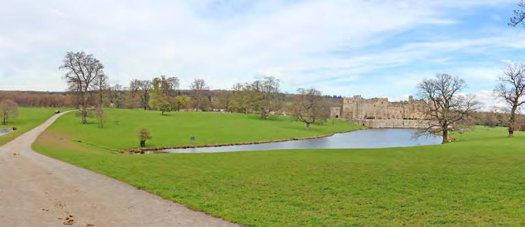
The landscape surrounding Raby Castle is a gently undulating open landscape interspersed with tree stands and larger areas of woodland. The land rises from the Langley Beck which runs along the southern boundary of the Park on the edge of Staindrop, and gently climbs to the north and west. The Ponds within Raby Park were constructed in the mid-eighteenth century following the draining of the moat and lie within a shallow valley. The topography is such that views of the village of Staindrop from within the Park are extremely limited following antiquarian designers seeking to keep the commoners out of sight of the castle.
2.3 O WNERSHIP, MANAGEMENT AND USE
2.3.1 T HE ESTATE
Raby Castle and its associated Estate is the ancestral home of Lord Barnard. It is spread across Teesdale and County Durham and is a substantial agricultural estate which provides an important source of income. There are thousands of acres of arable, grazing and moorland and a large area of managed woodland. The Estate surrounding the Castle is managed from Home Farm in Raby Park but there are many other tenanted farms, residential houses and cottages in villages around Teesdale, including whitewashed farmsteads where families have been tenants for several generations. Home Farm is part of the national Countryside Stewardship Scheme where farming practices are modified to enhance flora and fauna on the lower Estate.
Raby Estates also generates income from the forestry and the sale of logs, property rental, shooting parties, filming, and game. Venison and Game, such as pheasant, grouse, and partridge are produced on the lower Raby Estate. The Raby Estate has been described as one of the best sporting estates in the country for its wild bird shoots.01 The Estate offers a low ground shoot within Raby Park. Currently the Estate offers shooting days for up to nine guns, including ammunition, transport and lunch.
Timber production is an on-going part of the Estates’ woodland management, with a mixture of hardwood and softwood milling timber being cut on a regular basis. The Estate now provides firewood to domestic and commercial customers and Christmas trees, grown on the Estates’ plantations are sold during December from the Christmas Shop at Raby Castle.
Conservation is an important focus for the Estate, the management of this is explained in more detail in Section 2.9.4. The Farm, Forestry and Game departments of the Estate all work in unison to ensure that land management practices balance conservation with agricultural objectives and standards.
The Raby Estate also employs a large team of craftsmen to develop and maintain properties and buildings across the Estate, including the gardeners serving the Walled Gardens.
2.3.2 T HE CASTLE AND VISITOR OPERATIONS
Raby Castle is open to visitors in the summer between 11am and 4.30pm. The Park, gardens and tearooms are open every day from 9am to 5pm. Following the death of the 11th Lord Barnard in 2016, Lord and L ady Barnard committed to making Raby Castle their home and to strengthen its viability and ties to the local and wider community. A new IT system has been implemented, with associated accounts and property management systems to increase efficiency.
In 2017 and 2018, the Estate has begun to open up the site to new visitors. The 2018 season is being used as a soft market test for understanding visitor numbers, dwell times and demographics. The opening times have been extended and the café has been refurbished for the 2018 season. Ticketed access has been moved from the entrance lodge to the stables and Walled Gardens area to allow visitors to use the tearooms without paying an entry fee. Ticketed entry is currently only for the Castle and Walled Gardens.
2.3.3 C URRENT USES
The Raby Estate has a variety of uses, from agriculture, forestry, conservation works, and shooting to tenanted properties, tours, walks and bike hire, tearooms, family activities, formal gardens, filming and special events.
Raby Park can be hired for corporate or public events such as musical concerts, country fairs, car rallies or product launches. Currently, the main annual events are car rallies, a Christmas market and flower shows.
In 2018, Royal wedding celebrations were held, along with a 10k race for Teesdale Athletics Club, and outdoor pop-up theatre events.
Raby Park provides over 200 acres of parkland for visitors to enjoy, but the majority walk in the immediate grounds around the Castle. Bike hire has recently been introduced and there are a number of unmarked trails around the ponds and Castle.
01 One of the “50 Best Sporting Estates” according to The Field (March, 2010)
11 UNDERSTANDING RABY PARK
Contents
MANAGEMENT STRUCTURE AND REPORTING
TRUSTEES
Lord Inglewood
Sir Jocelyn Gore-Booth
DURHAM PROPERTIES
John Wallis/ GSC Raby Estate Marwood Estate UT Estate
LEISURE/ TOURISM
LORD AND LADY BARNARD
ADVISORY BOARD
CEO Duncan Peake
Duncan Peake Environmental Manorial Rights Minerals
Claire Jones Castle Opening Café Retail Events High Force Castle, Park & Gardens
Curator / Archives Security
SPORTING
John Wallis / GSC
Iain Alexander Raby Shoot Deer Management Andrew Hyslop Upper Teesdale Shoot
FORESTRY
Geoff Turnbull Woodland Management Estate Maintenance Firewood Christmas Trees
FARMING
Robert Sullivan / GSC
Raby Home Farm Sebastian Graff-Baker / Andersons
Raby Farm Shropshire
SHROPSHIRE ESTATE
Tom Birtles (Jul 2018)
FINANCE
Josie Graham
SERVICES
DEPTS
ESTATE WORKS Philip Dent OPERATIONS
Katrina Appleyard IT SUPPORT
To be Appointed
HUMAN RESOURCES
Katrina Appleyard/ HR2Day
HEALTH AND S AFETY Lycetts
12 UNDERSTANDING RABY PARK
Contents
2.4 H ERITAGE PROTECTION AND DESIGNATIONS
2.4.1
S CHEDULED MONUMENTS
Scheduling derives its authority from the Ancient Monuments and Archaeological Areas Act of 1979 and is the selection of nationally important archaeological sites.02 Despite its age and significance, Raby Castle is not a Scheduled Monument and there are no Scheduled Monuments within the site boundary.
2.4.2
L ISTED BUILDINGS
Listed buildings are structures of special architectural and historic interest which make up England’s historic environment. They are protected under the Planning (Listed Buildings and Conservation Areas) Act 1990 and alterations or demolitions require Listed Building Consent from the local planning authority before they can proceed.
There are 24 listed buildings and structures which lie within the boundary of the site; within the stables and Walled Raby castle. Raby Castle and the listed buildings within the wider park are shown opposite and include:

01 Raby Castle, Grade I (1338625) 02 North gatehouse and attached Grade I (1338626) 03 The Folly, Grade II* (1121773) 04 North Lodges with North Grade II (133806) 05 Gas House, Grade II (1310898) 06 Temple, Grade II (1121784) 07 Bath House Cottage, Grade 08 Bath House, Grade II (1160046) 09 Footbridge, Grade II (1310742) 10 Boundary Stone, Grade II 11 Boundary Stone, Grade II 12 South Entrance Gateway (1338629)
02 Historic England: https://historicengland.org.uk/listing/what-isdesignation/scheduled-monuments/ Last accessed 25/05/2018
13 UNDERSTANDING RABY PARK
Registered Park and Garden Boundary of Raby Park (red), with a minor extension to the north-west (blue). The Walled Gardens are shown in green. Base plan ©2018 Infoterra & Bluesky and 2018 Getmapping plc N 01 06 11 02 07 12 03 08 04 09 05 10 Contents
The Walled Gardens and stables area contains the following Listed Buildings and their location is shown opposite:
01 Stables and Coach house with wall and mounting block, Grade II* (1121776)
02 Dutch barn, Grade II* (1121777)
03 Stable Block, Grade II (1310772)
04 Riding School, Grade II (1121778)
05 Hunting stables, Grade II (1160037)
06 Piers and Walls, Grade II (1121782)
07 Byre House, Grade II (1121779)
08 Former Cart House stables, Grade II (1310780)
09 Gardener’s House, Grade II (1121781)
10 Raby Park House and Butler Cottage and Outbuildings, Grade II, (1391549)
11 Cistern in Walled Garden, Grade II (1310785)
12 Garden Walls and Gateway with attached Fig House, Grade II (1121780)
The list descriptions have been reproduced within the appendix.
DESIGNATIONS: WALLED GARDENS AND STABLES AREA Walls Grade II* Grade II Non-designated Hardstanding Trees This plan is not to scale

EGISTERED PARKS AND GARDENS
Parks and Gardens of special istoric interest in England’ is managed by Historic over 1,600 sites which have particular significance, with n emphasis on ‘designed’ landscapes as opposed to mportance.03
consideration’ in the planning planning authorities must proposed development on he landscapes’ special character.
registered park and garden. The lies within the boundary of he registered area which is shown on the plan on page
03 Historic England: Registered Parks & Gardens: https:// historicengland.org.uk/listing/what-is-designation/registered-parksand-gardens/ [last accessed 4th June 2018]
14 UNDERSTANDING RABY PARK
03 02 04 01 08 07 06 05 12 11 12 12 12
10 Contents
N
09
2.5 O VERALL CONDITION
The Castle and listed estate properties are of a quinquennial survey. The most recent condition survey (QI) was carried out in May 2018 by Insall Associates. They have concluded that Castle continues to be maintained in a relatively condition. Within their report, they have recommended a number of works to the fabric which should be undertaken over the next five years. These redecoration of all joinery and metalwork of Castle and listed buildings, further repointing to the Moat Walls, refurbishment of a number of key apartments and rooms within the Castle, renewal of lead roofs to the Keep and South Range and Clifford’s Tower roof, renewal of the slate roof central Coach House building, restoration of House interiors and repairs to the North Wall of the Walled Garden, which continues to bulge at end.
The detailed condition of Raby Castle is outside scope of this report but further detail on the of the listed buildings within the Walled Garden Stable area are included within individual entries Gazetteer in Volume 2. The adjacent plan gives summary of condition of the buildings proposed focus of future development.

CONDITION: WALLED GARDENS AND STABLES A REA
Serious delapidation and redundant. works required Moderate delapidation and redundant/in ‘meanwhile’ use. Substantial repairs required Fair condition and redundant/in ‘meanwhile’ use. Repairs required Satisfactory condition and in use. Regular maintenance required
Note: Upper floors are generally unused relatively worse condition overall. This plan is not to scale
THE L AUNDRY
UNDERSTANDING RABY PARK
N
Contents
2.6 C HARACTER AREAS


2.6.1 W IDER LANDSCAPE CHARACTER AREAS


The following character areas are those considered in detail within the Gazetteer of Volume Two

16
UNDERSTANDING RABY PARK
NORTH WOOD
INNER PARK
WALLED GARDEN
NORTH PASTURE
KENNEL WOOD
BATH WOOD
Contents
LADY CLOSE WOOD


17 UNDERSTANDING RABY PARK
The following structures are those considered in detail within the Gazetteer of Volume Two. 13L 12L 11L 9L and10L 8L 7L 6L 5L 4L 3 L 2L 1L WALLED GARDEN AND STABLES AREA NURSERY N 4L: KENNEL HOUSE AND WOOD NURSERY 2L: HOME FARM WALLED GARDEN AND STABLES AREA 3L: THE LAUNDRY 1L: CASTLE 5L: KENNEL WOOD COTTAGES Contents
2.7 B UILT HERITAGE COMPONENTS 2.7.1 R ABY PARK COMPONENTS


18 UNDERSTANDING RABY PARK 13L 12L 11L 9L and10L 8L 7L 6L 5L 4L 3 L 2L 1L WALLED GARDEN AND STABLES AREA NURSERY N 6L: RABY HILL HOUSE 9L: BATH HOUSE 10L: BATH HOUSE COTTAGE 8L: SOUTH LODGE 13L: GAS HOUSE 11L: TEMPLE (BELVEDERE) 7L: NORTH LODGE 12L: NORTH WOOD FOLLY Contents
2.7.2 WALLED GARDENS AND STABLES CHARACTER AREAS
The adjacent plan sets out the six character areas of the Walled Garden and stables area, denoted by colour. The 20 sub-areas are shown on the following pages and considered in detail within the Gazetteer of Volume Two.
N
CHARACTER AREAS
Gardens Ancillary Gardens Stables Maintenance and Farmyard Residential Boundary Planting
This plan is not to scale
UNDERSTANDING RABY PARK
Contents


20 UNDERSTANDING RABY PARK
A: WALLED GARDEN (EAST)
D:
BOUNDARY TERRACE B: WALLED GARDEN (CENTRAL) Contents
C: WALLED GARDEN (WEST)
E: GARDENER'S HOUSE GARDEN
F: ANCILLARY ENCLOSURE (WEST)


21 UNDERSTANDING RABY PARK
L: FORMER WALLED GARDEN (NORTH)
M: RAFF YARD
J: AVENUE
I: HUNTING STABLES COURTYARD H: STABLES AND COACH HOUSE G: ANCILLARY ENCLOSURE (EAST)
K: RABY PARK HOUSE GARDEN Contents
N


22 UNDERSTANDING RABY PARK Q: STABLE AND PIGGERIES
T:
COURTYARD
CAR PARKING
N Contents
P: STABLE YARD ACCESS SPINE O: OUTER RAFF YARD R: BOUNDARY PLANTING N: HAY BARN S: BYRE HOUSE GARDEN
2.7.3 WALLED GARDENS AND STABLES AREA


The following structures, both listed and unlisted, are those considered in detail in the Gazetteer of Volume Two.

23
UNDERSTANDING RABY PARK
N
4S:
1S:
5S:
3S:
2S:
Contents
7S: DUTCH BARN C.300 METRES NORTH OF STABLES AND COACH HOUSE 6S: STABLE BLOCK NORTH-EST OF STABLES AND COACH HOUSE
CART
HORSE STABLES ATTACHED TO BYRE HOUSE
PIERS AND WALLS NORTH-EAST OF HUNTING STABLES
OUT-BUILDINGS
TO NORTH OF FORMER CART HORSE STABLES
BYRE HOUSE 8S: RIDING SCHOOL C.10 METRES NORTH OF STABLES AND COACH HOUSE 9S: STABLES AND COACH HOUSE, WITH WALL AND MOUNTING-BLOCK ATTACHED
THE HUNTING STABLES


24 UNDERSTANDING RABY PARK
15S:
13S: OUTBUILDINGS
STORAGE
12S:
14S: LEAN-TO
18S:
10S:
11S:
17S:
N Contents
16S: OUTBUILDINGS NORTH OF WALLED GARDEN
RAFF YARD HOUSE
AND
SHEDS TO NORTH-EAST OF RAFF HOUSE
FORMER SMITHY NORTH OF THE DUTCH BARN
SHED EAST OF RAFF HOUSE
BARNS TO NORTH OF GARDENER’S HOUSE
OUTBUILDINGS NORTH OF DUTCH BARN
OUTBUILDINGS TO REAR OF STABLE BLOCK NORTH-EAST OF COACH HOUSE
RABY PARK HOUSE AND BUTLER COTTAGE AND OUTBUILDINGS


25 UNDERSTANDING RABY PARK 23S:
24S:
22S:
25S: OUTBUILDINGS AND GLAZED CANOPIES TO COACH HOUSE YARD 28S: COTTAGE
RAFF
26S: CISTERN IN WALLED GARDEN 27S: GARDEN
GATEWAY
FIG HOUSE 19S:
21S:
NORTH
20S:
N Contents
MODERN GLASSHOUSE
GARDEN SEAT TO SOUTH OF GARDEN WALL
OUTBUILDINGS
NORTH OF GARDEN WALL
TO
YARD
WALLS AND
WITH
GARDENER’S HOUSE IN WALLED GARDEN
OUTBUILDINGS AND GLASSHOUSE
AND SOUTH OF GARDEN WALLS
BARN ESTATE YARD
2.7.4 R ABY CASTLE OVERVIEW
The Manor of Rabi formed land belonging to Staindrop, given to the Prior of Durham by King Cnut in the 11th century. This suggests an early medieval presence on the site that was subsequently consumed by major and systematic medieval redevelopment. This culminated in the creation of the 14th century castle under the Nevill family, which still stands today.
The Nevill family lost control of Raby to the Crown following the failure of the Rising of the North in 1569. Sir Henry Vane the Elder acquired Raby from the Crown in 1626, forming the commencement of the line of succession to the present Lord Barnard.
In 1648, during the English Civil War, the castle was besieged, but is considered to have suffered little in the way of damage. The building was maintained in general terms until major alterations took place in the eighteenth century. Following an episode of family unrest (resulting in part of the medieval building being dismantled under the 1st Lord Barnard) a programme of restoration and improvement was put in hand by the 2nd Lord Barnard. This included major enhancements in the south and west ranges under the guidance of the acclaimed architect James Paine, forming opulent stately apartments and entertaining spaces. Under the instruction of Henry, 2nd Earl of Darlington, further work designed by John Carr was carried out on the castle, both inside and out, and around the estate. This included the carriageway in the main Entrance Hall and the creation of the round tower on the South Front. By the close of the eighteenth century major landscape improvement had been carried out, taking in the setting of the castle itself and the draining of the moat.
Further significant changes took place in the nineteenth century. From 1843 William Burn added to the South Front and created the Octagon Drawing Room. Further refinements were added in the 1890s under the 9th Lord Barnard. Thereafter, changes are considered to have been more modest, and concerned the ongoing operational and domestic functions of the Castle site.
Raby Castle has illustrative historic value as a perfected example of the lay medieval castle concept in the landscape, irrespective of its post-medieval changes and enhancements. Its developmental history from the medieval period to the twentieth century can be closely read, and it is a high-quality example of how medieval properties were upgraded and re-presented in the eighteenth and nineteenth centuries. Illustrative value also lies in the plan form and treatment of the key spaces, enabling their historic functions and relationships to be understood and interpreted.

The Castle has powerful associative historic value for its focal and emblematic connection with Raby Estates and generations of the Nevill and Vane families. It also shares close associations with an array of innovators, designers and architects including James Paine and John Carr. A connection with the great medieval architect of the North, John Lleweyn, is also possible.
Raby Castle also has exceptional aesthetic value. Its setting in the designed landscape invokes a strong sense of the Picturesque, enhanced by its design language and use of local traditional materials. It is an imposing and captivating spectacle with the landscape designed and sculpted to form framed and dynamic views, experience and discovered by following the eighteenth century processional route from the South Lodge. The castle has communal value as the emblem of Raby and Staindrop, as a family home for generations, as a place of work, and as a place for the wider community to visit and enjoy.
The Castle is set upon a raised plinth of land, bordered by a dry moat and accessed via a gatehouse on the north-west corner. The Low and High Ponds, bridged by banked ground at their intersection, extend westward from the southern side of the moat edge. The Castle is built of local Carboniferous sandstone, with roof coverings of lead or slate. Irrespective of post-medieval improvements, the site is robustly medieval in its language and character.
The castle comprises a sequence of imposing blocks and towers, interlinked to form a series of continuous ranges set around a central courtyard, entered via the inner Nevill Gateway on the W side. Internally, a range of high quality period state rooms exist including the Entrance Hall, Baron’s Hall, Chapel, Dining Room, Library, Octagon Drawing Room, and Small Drawing Room. The Servants’ Hall and Kitchen are also of great
interest, the latter being 14th-century in date and most likely designed by John Lleweyn, the famous master mason of the Great Kitchen at Durham Cathedral. A network of bedroom, service and domestic spaces complete the historic room allocations within the castle, now either occupied by operations staff or serving as private accommodation.
26 UNDERSTANDING RABY PARK
Contents
Raby Castle viewed from the south-west
2.7.5 WALLED GARDENS AND STABLES AREA OVERVIEW
The Walled Gardens within this complex include the three southern gardens and the northern garden within the walled/ha-ha area. These areas represent the spaces laid out as productive horticultural areas and pleasure grounds. The main walled gardens historically provided for the production of fruit and vegetable as well as an opportunity to display exotic plants to visitors. The spaces are characterised by their planting, with well-established trees and shrubs, areas of lawn and well-maintained beds. They are also compartmentalised by tall walls, providing security and areas for training plants.
Also within this area are the stables, the agricultural farm buildings and the maintenance and service areas of Raff Yard. The complex has three dwellings which are currently in residential use the Gardener's House, Byre House and Raby Park House. Historically, Raff Yard House was also a residential dwelling but is now vacant. Other areas include ancillary spaces serving the gardens, Duchess' Walk (avenue), the grassed area outside the southern wall, car parking and the northsouth spine road.
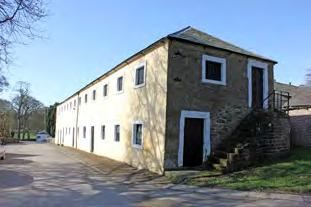
Stables
The stables relates to the equine accommodation for Raby Castle. This ranges from hunting stables for high-quality animals, through to carriage horses and cart horses. The associated coach house and motor car garaging complete this area, dedicated to transport and travel. The character of the area is one of hard surfaces and polite external exteriors of buildings, designed to be seen by visitors. The quality and use of the stables changes across the site, from the highest quality to the south near the Castle, moving northward along the spine road towards Raff Yard. The primary buildings are limewashed in pale yellow with white window and door surrounds, added to the group value of this significant ensemble. The riding school is a functional building of some rarity nationally that is linked to these uses.
Raff Yard and agricultural buildings
The Raff Yard has defined boundaries within two distinct courtyards the earlier Raff Yard and the outer courtyard associated with the hay barn. Raff Yard is a maintenance yard, containing the workshops and offices, associated with the supply, maintenance and upkeep of the Castle and Estate. The courtyard has evolved into the gardens of Raff Yard House. To the west, cart sheds and barns define the spaces in between them, which were originally hardstanding but have turned to grass. The hay barn dominates this area. The agricultural buildings link the polite stables to the functional maintenance yard to the rear and consist of cow byres and pigsties. Some were more architecturally detailed than others but all provided services to the Castle and family. The hay barn in particular holds significance and is a good example of the type nationally.
View from the Castle
The Walled Gardens sit on a gentle, southwards-facing slope c.100m north of the Castle. It is a rectangular, brick-walled enclosure with the back of an L-shaped stable range at the north-east corner and a serpentine south wall. A grassed border and walkway runs immediately south of this wall, separated from the park by a ha-ha with a stream running through it. A bridge with a parapet surmounted by cast-iron railings and a cast-iron gate on the park side crosses the haha and leads to a central entrance (listed Grade II with the garden walls) which was brought to the site from Shipbourne in Kent in the early twentieth century. 25m west of the entrance there is a fig house which replaced earlier buildings of the eighteenth and nineteenth century for a fig which is thought to have been planted in the eighteenth century. The walls on the south side were designed to be heated by flues and the original boiler house survives at the bottom of the Central Garden. The ha-ha runs around the west side of the garden and continues around the complex of stables and ancillary buildings which lie immediately north of the garden. The north and west sides of the enclosure are sheltered by trees.
Central Garden (character area B)
The central entrance leads to the central enclosure and a path flanked by clipped yew hedges. This runs north up the slope to a circular lily pond. The yew hedges continue northwards, as more mature specimens, flanking a lawn with geometric beds and a terrace which runs along the north side of the garden with a lead cistern dated 1746 (listed Grade II) set into the centre of the revetment wall. The terraced walk, from which there are views over the garden to the Castle standing in parkland to the south, continues eastwards through an arch cut into the hedge and leads to an enclosure formed by the hedge and wall dividing the garden from its eastern neighbour. A summerhouse, probably of 1930s or later date, is positioned against the north wall and stone steps lead down to a garden with clipped box hedges and a formal pattern of gravel walks. Plinths supporting urns of eighteenth century date are positioned at various points around this part of the garden. On the west side of the yew hedges the terraced walk continues westwards and there is a glasshouse positioned against the north wall.
Flanking gardens (character areas A and C) The gardens which flank the central walled compartment have lawns and borders. In the northwest corner of the west compartment (area C) there is a gardener’s house (listed Grade II) in the form of a Gothick cottage orné. In the south-east corner there is a small building with a chimney which is the boiler house for the fig house. The garden layout was largely created during the later twentieth century, following disruption during the Second World War for vegetable planting, incorporating pre-existing elements such as the yew hedges and central pool which are shown on the 1854-7 OS map.
Ancillary spaces
Immediately north of the Walled Gardens there is a walled enclosure with footings for glasshouses on the west side and a range of late twentieth century greenhouses on the east side. A gateway leads from the east end of the enclosure to the stables area.
The garden replaced one shown on a map of 1729 immediately south of the gatehouse.
Site Summary
Significance of the Walled gardens and stables area lies in its closeness to the Castle, in its functional connections and in the visibility of these areas, which were often hidden away by the eighteenth century. This may have been a matter of display, to showcase the exotic plants, but was also a response to the evolution of the location of the medieval village of Old Raby as it began to serve the Castle in a more formalised way. The area was developed in the late eighteenth century and remains an intact and well-organised area developed to provide ancillary functions to support the family and immediate Estate.
27 UNDERSTANDING RABY PARK
Contents
2.8 S ETTING AND KEY VIEWS
2.8.1 SETTING
Raby Castle cannot be isolated from how it is experienced within its setting of the Registered park and garden, the wider historic estate. Designed and incidental views, and an understanding of the historic relationships between the Castle and the ancillary structures that served it, add to aesthetic and historical value. The landscape today can still be read to illustrate the medieval castle set within its enclosed deer park. It also illustrates the later Picturesque and Romantic landscape movements, with emphasis not on the military fortress, but on the polite south front and views from the carriage drive, which was diverted for this very purpose.
The Walled Gardens and stables are of interest for their close visual and functional relationship with the Castle. Early examples of walled gardens from the seventeenth or early eighteenth century could be areas of conspicuous display and highly visible, such as those at Auckland Castle, however as these became more common in the late eighteenth to early nineteenth century they were generally laid out away from the main house.04 At Raby Castle, the gardens remained visually dominant within the landscape, as although there were no views from principal rooms within the Castle (which all face south), the key view of the south elevation across the lakes also draws in the gently sloping walled gardens and stables. The reason for this location may have been a continuing matter of display, showcasing exotic plants, but was also a practical response to the evolution of the location of the medieval village of Old Raby and its field systems. The formalisation of the stable and farm functions serving the Castle and the sweeping away of the old village fits into a pattern of landscape change seen nationally. The functional and formal relationship of the walled garden area within the setting of the Castle remains highly significant and is relatively rare in terms of visibility, if not functionality.
Links between the powerful house at the heart of the Estate and the other structures that served it are both visual and physical. A key designed view from the Castle leads directly to Home Farm, which sustained the Estate. Key historic routes between the Castle and farm strengthen this setting and connections. Routes into the Estate have changed overtime, with the South, Middle and North Lodges all being the principal entrance at different periods in time. This changed in response to how the estate was used and perceived. connections are now less obvious. The link the use of the Bath House as a healthy and
pastime by those at the Castle is eroded through loss of garden features, planting, routes and the declining condition of the building itself. Few elements within the setting of the Castle make an actively negative contribution to setting, due to the relatively intact landscape surroundings. Improvements to dense modern planting and the requirement for succession planting of historic trees both have the potential to impact on setting. Modern road surfaces, car parking and the declining condition of some structures may also be considered as having a negative impact.
The setting of the Castle and the wider setting of the Registered landscape (views and experiences of drivers along Keverstone Bank for example) should be taken into account when proposing change that will sustain or enhance significance. The character areas identified in this Conservation Plan are of importance as elements of the Registered parkland but also as the setting within which the designated heritage assets are experienced.05
Each of the wider landscape and Walled Garden character areas are described in detail in the gazetteer and an understanding of these spaces should be used to manage change in a way that will sustain significance.

SETTING
Functional Formal Permeable north-south divide between the functional and formal
This plan is not to scale
04 https://content.historicengland.org.uk/images-books/publications/ dlsg-garden-park-structures/heag108-garden-and-park-structureslsg.pdf
The immediate setting of the heritage assets within the Walled Gardens and stables area are defined by their historic (and to some extent, continued) uses from the formal to the functional.
05 Historic England, Conservation Principles, 2008
N
28 UNDERSTANDING RABY PARK
Contents
2.8.2 W IDER LANDSCAPE KEY VIEWS
The designed parkland at Raby was developed during the eighteenth century in response to the evolving fashion for naturalistic landscape. The informal rolling parkland was designed with long winding drives from which to view the landscape, eye catching buildings and water, all linked by vistas and points from which to take in the prospect.
Key views include:
• Significant views looking towards the Castle from the parkland, in particular from the southern drive (views 1 and 5).
• Panoramic views on all sides of the castle, with long-distance views over the lakes and parkland to the south (views 2 and 4).
• Borrowed views east beyond the park due to the open character of the eastern boundary. These have partially been lost due to increased tree planting along the A688 (view 18).
• Long views west across parkland as far as Old Lodge. The Registered Park once formed the heart of a much larger parkland. These have been lost due to increased planting along the western boundary of the Registered Park, and conversion of parkland to farmland (views 6 and 19).
KEY VIEWS
Lost designed views
Surviving designed views
Dynamic views
Incidental views
Panoramic viewpoint
Lost views of wider parkland
This plan is not to scale

29 UNDERSTANDING RABY PARK
N 01 06 11 16 02 07 12 17 03 08 13 18 04 09 14 19 19 05 10 15 20
Contents


30 UNDERSTANDING RABY PARK 01 02 03 04 05 Contents


31 UNDERSTANDING RABY PARK
06 07 08 09 Contents
Kennel Wood Cottage Home Farm Kennel House


32 UNDERSTANDING RABY PARK 11 12 13 14 10 Contents


33 UNDERSTANDING RABY PARK 16 17 18 19 15 20 Contents
2.8.3 WALLED GARDEN AND STABLES AREA KEY VIEWS

KEY VIEWS
Lost designed views Surviving designed views Dynamic views Incidental views Panoramic viewpoint 01 Panoramic designed view from Walled 02 Panoramic designed view from Walled 03 Panoramic designed view from Walled 04 Dynamic view from Walled Garden to Castle 05 Dynamic view towards the stables and house 06 Dynamic view towards the Castle 07 Incidental view across the car park 08 Dynamic view into the stable yard 09 Designed view along the avenue 10 Incidental view towards the hay barn 11 Incidental view towards the hunting stables 12 Incidental view towards the cart horse 13 Incidental view towards the hay barn 14 Incidental view from Raby Park House towards the Castle 15 Incidental view from the yard towards the Castle A View 4 (wider landscape) see page 29 This plan is not to scale
UNDERSTANDING RABY PARK
08 13 07 06 12 10 05 11 01 09 14 02 15 03 04 A N Contents
2.9 LANDSCAPE
2.9.1 ECOLOGY/ARBORICULTURE
Woodland
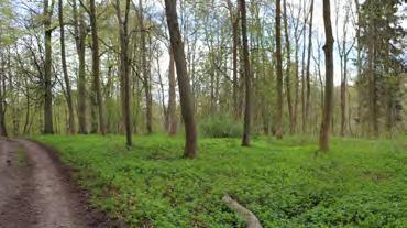
The woodland found at Raby predominantly contains Beech with some Oak and Larch. The woodland was laid out in the mid-eighteenth century as landscaped parkland as well as for game cover. Younger woodland is primarily pockets of spruce plantation set within North Wood and Ladys Close Wood which are felled for timber crop. Christmas trees, grown on the Estates’ plantations are sold during December. Since the eighteenth century woodland cover has grown only slightly within the Raby Park however the overall woodland layout has remained similar.
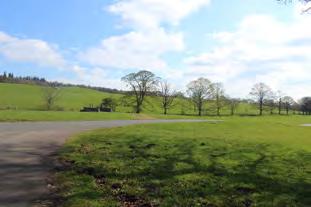
Parkland Trees and Copses


Parkland tree species are primarily a mixture of Oak and Beech. There is a long history of parkland trees and clumps being planted, removed and in some cases replanted over the years for various reasons such as views and to commemorate special events, such as Royal visits, during the twentieth century. Clumps of significance include a small plantation to the west of the castle made in 1903 to commemorate the comingof-age of the Hon. H.C. Vane and a plantation from 1906 made on the drive from Staindrop to Raby which commemorates the Silver Wedding of the 9th Lord Barnard. Other trees planted commemorate Queen Victoria’s Diamond Jubilee, visit of Queen Mary to Raby, visit of Princess Henry of Battenburg and the Queen of Spain, Coronation of King Edward VII.
The 10th Lord Barnard (d. 1964) was a keen forester and established new clumps and plantations. He replanted ancient clumps and replaced trees lost from the original landscaping plans.
The condition of parkland trees varies depending on age. Veteran trees within the Parkland may be hollow, with significant amounts of dead and decaying timber.
Ecology

The landscape contains a rich mosaic of habitats and numerous habitat corridors, thus providing the foundations of a very diverse ecology. These include running waters; ponds in bright sunshine and shady situations with varying levels of intervention. In addition, there are eroded bank-sides, grassy margins, as well as areas of damp grassland. The river and ponds are UK BAP (Biodiversity Action Plan) Priority Habitats. Wood pasture and parkland is a UK BAP Priority Habitat. Scrub within the woodlands also provides a vital nectar source for invertebrates.

35 UNDERSTANDING RABY PARK
Contents
2.9.2 CONDITION STRUCTURE AND LANDSCAPE
Landscape Feature Condition
Access Routes and Car Park Main Parkland routes from North Lodge and access routes surrounding the Walled Gardens and stables area and Raby Castle are in fair condition. Access routes are in less favourable condition further from the main complex. The existing car park is informal with no road markings and worn grass edges.
Boundary treatments Ha-ha and estate railings are predominantly in good condition and appropriate in locations dictated by views and containment of livestock. Drainage problems associated with stone ha-ha’s within the wider parkland setting, some of which are in less favourable condition, particularly around Bath Wood. Walls along the southern and northern park boundaries appear to be well maintained.
Water Bodies (High Pond and Low Pond)
Play area and Cricket Pavilion
Both High and Low Pond appear to be well maintained aesthetically and are one of the most significant landscape features within the setting of Raby Castle. The water bodies have ecological value and are used by waterfowl as well as deer.
The play area is currently under utilised due to its peripheral location however there are excellent views of Raby Castle from the edge of the surrounding woodland.
Raby Castle cricket pitch is well maintained and greatly utilised by the public, again having spectacular views of the Castle. There is currently no formal access to the pavilion. An informal route along the neighbouring tree avenue appears to be used and could be improved.
Woodland Overall woodland management maintains the original intentions of the designed Parkland such as limiting certain views and providing game cover.
Accessibility in Bath Wood is currently limited, drainage and stand stability are an issue and scrub and rhododendron are encroaching on paths and structures such as the Ice House.
Open Parkland Pasture and Parkland Trees
Loss of parkland trees has contributed to a decline in the aesthetic value of the parkland. The angular edges of some tree clumps are inconsistent with the more rounded, natural form of the former parkland landscape. Current levels of stock grazing within the parkland maintains the sward to an appropriate height and species composition.
36 UNDERSTANDING RABY PARK
Contents
2.9.3 CURRENT RELATIONSHIP OF LANDSCAPE TO S TRUCTURES
The subsidiary structures cottages, gardens, farms, etc.– all contribute to the overall significance of the landscape because they were and are essential to the operation and character of a great estate.
Landscape within Raby Park is currently heavily dictated by the condition and uses of buildings associated with the Estate. Building typology and their relationship with contextual landscape can be simplified into the three following categories: buildings accessible to the public and Estate staff; private buildings tenanted out; and structures at risk. These are visually depicted on page 42
Public
1 Buildings including the Castle, stables and structures within the walled garden can be characterised as follows:
o Strong visual relationships to the Wider Estate.
o L andscape is well maintained in view of these buildings.
o L andscape structure is generally simple and accessible.
o Materiality is of a high quality, able to withstand a high level of use.
Private
2 Buildings include South and West Lodge, Kennel House and Raby Hill House.
o Private dwellings have become domesticated over the years.
o Private gardens in the immediate context contain mixed planting and fencing.
o Differ in aesthetic qualities to buildings accessible to the public.
Risk
3 Buildings include The Bath House, The Gothic Pavilion, The Laundry, Gas House, The North Wood Folly, the Dutch barn & Raff House.
o A ssociated landscape setting has in most cases been lost due to lack of maintenance. This includes degradation of path networks and designed planting.
o A ssociated landscape is rarely used and lacks visual connectivity to the wider Estate setting due to vegetation overgrowth.
In addition to buildings, boundaries such as stone ha-ha's and walls within and enclosing the Parkland are significant structures used currently not only to manage deer but provide an important visual language to visitors to Raby Park in terms of accessibility. The use of ha-ha’s remains a strong characteristic of Raby Estate proposed in order to maintain views to the wider Parkland. Walls stretching the length of the Northern, southern and eastern extents of the Estate also provide distinctive bookends to the wider parkland.
37 UNDERSTANDING RABY PARK
Contents
PARKLAND ANALYSIS
Parkland Boundary
Stone Ha-Ha Stone Walls
Buildings accessible to the public and estate staff


Private buildings let to the estate staff. Structures at risk
N
38 UNDERSTANDING RABY PARK
This plan is not to scale Contents
HISTORIC TREE PLANTING
Lost trees since 1st edition 1860 New woodland / trees since 1st edition 1860 New woodland since Dixon Plan 1812 Modern field boundary dividing parkland

IGNIFICANT MODERN TREE CLUMPS
Vane Clump 02 Millennium Clump (Silver Jubilee of HM the Queen 1977) 03 Silver Wedding Clump 0 4 Park Clump
TARGET NOTES
A Informal tree planting along route now a formal avenue B Former avenue along the Terrace Walk now dense plantation C Lost tree clumps along the south side of the drive to West Lodge D Additional planting within the park to the north of Lady Close Wood planted by 3rd Earl of Darlington E Gothic Pavilion (referred to as the ‘Temple’ on the 1st edition OS map) This plan is not to scale
The major trees planted in the 18th century were recorded in a document entitled: “Trees planted about Raby”.
This lists planting carried out by Gilbert, 2nd Lord Barnard, 1727–1749 and was the first landscaping of Raby Park. It is not known who advised Lord Barnard, but it may have been James Paine. Major phases of planting include:
• 1727 The Elms below the bowling green near Low Pond
• 1740 Elms and beeches by the Bowling Green Road
• 1743 Great ha-ha, terraces, ditch and plantation made
• 1743 the deer park wall made
• 1743 The new or Great Pond made
• 1744 The bowling green, ha-ha terraces made
• 1748 Trees planted in the Alders
• 1748 Planting Trees at the Bath where the Oaks died
• 1746 Elms, Beeches next to George close in road to the Bath
• 1748 Young elms, beeches near the duck pond in the Alders
• 1749 Park wall made next the Turnpike road
39 UNDERSTANDING
RABY PARK Overlay of 1st edition OS map 1860 on current aerial. Base plan ©2018 Infoterra & Bluesky and 2018 Getmapping plc
S
01
Parkland tree
Parkland tree
3 4
2 North
Kennel
Bath
Lady
Sandy
E A
D
loss
loss
1
Wood
Wood The Terrace
Wood
Close Wood
Bank Wood
B C
N
Contents
2.9.4 WIDER LANDSCAPE INVESTIGATIONS Biodiversity And Natural Conservation
At the time of writing no ecological, biodiversity or arboricultural investigations have been carried out and no detailed assessment of the condition of the landscape has been made. It is anticipated further assessment and survey work will be carried out as options and development opportunities are explored.
The Raby Estate supports good conservation and there has been a focus on encouraging wild game and wildlife throughout the Estate. Advice has been sought from the Game & Wildlife Conservation Trust (GWCT) since 1991 and the Estate has implemented a rigid management policy to help encourage plant growth and wildlife.
Conservation headlands six metres wide have been introduced, which encourage the growth of broadleaf weeds and their associated insects, providing an abundance of food on which game bird chicks and small songbirds feed. The prevention of cleavers and barren brome invasion of cereal crops was achieved by the introduction of one metre sterile strips between field boundaries and headlands. This practice has contributed to Raby seeing some of the highest populations of grey partridge in some years.
To assist the grey partridge survival, plots of game cover mixture, incorporated with wild bird set-aside cropping, have been introduced to provide the partridge cover throughout the winter months, which helps reduce losses suffered from the talons of sparrow hawk. Within these plots it was noticed that large numbers of small seed gatting songbirds frequent these areas, which lead to a new project which was partially funded by GWCT and Kings Seeds. The three-year project was initiated to determine which crops suited song bird populations best. The project has encouraged a wide range of songbirds such as linnet, redpolls, goldfinches and skylarks.
Beyond the scope of the Raby Park boundary, Raby’s Upper Teesdale Estate is nationally and internationally known, both for its botany and ornithology. The Estate has UNESCO Geopark status. The plants assemblage is unique in Britain and the density and diversity of the birds probably the best in mainland Britain. In recognition of this, the majority of the Estate is a Site of Special, Scientific Interest (SSSI). Such is the quality of the habitat that much of the Estate is a Special Area of Conservation (SAC), and because of the density and diversity of birdlife it is also a Special Protection Area (SPA). This has resulted in Upper Teesdale being very popular with botanists and ornithologists alike.
Some of the Upper Teesdale Estate forms part of The Moorhouse and Upper Teesdale National Nature Reserve. The Estate has developed a working relationship with Natural England (NE) and in conjunction with NE and the tenant farmers, a number of conservation strategies are being implemented.
For example, the extensive moorland drainage system that was implemented after the Second World War in an effort to boost food production, led to quite severe erosion of the peat in places. Raby Estate, in conjunction with NE and the North Pennines Area of Outstanding Natural Beauty (AONB) was the first in the country to reverse this damage by blocking all the open moorland drains. This was done to slow down erosion of the moor caused by carbon or peat being carried away with the draining water. It has proved to have been a complete success with the vast majority of the drains now having re-vegetated with sphagnum moss. These drain blocks, which create countless small pools, are beneficial to wading birds as a source of food and have also enhanced the capacity of the moor to act as a carbon sink, soaking up carbon which is deposited from the atmosphere.06
Woodland and Forestry
Woodland forms an integral part of Raby Estates, with a diverse mixture of broadleaf and coniferous plantations occupying land from the moorland edge to the lowland margins of the River Tees.
The woodlands are sustainably managed under a longterm forest plan, which is independently certified to the UK Woodland Assurance Standard. In addition to commercial timber production, wildlife conservation and maintenance of the landscape are key objectives in the management of the plantations. Forest operations are carried out in a manner which maintains the biodiversity of the woodland and the beauty of the landscape in which they are situated.
An extensive replanting programme ensures that all clear-felled areas are appropriately regenerated. In a typical planting season approximately 21,000 coniferous and broadleaf trees are planted to ensure the continued growth of the woodland. The use of native broadleaves in traditionally hardwood areas and sensitive locations maintains the diversity of the plantations across the Estates.
06 http://www.rabycastle.com/the-estate/conservation
40 UNDERSTANDING RABY PARK
Contents
2.10 AR CHAEOLOGICAL POTENTIAL
There have been few recorded archaeological discoveries within the Park and surrounding area. A Neolithic polished stone axe (4,000–2,400 BC), however, was discovered in the nineteenth century in Raby Park. Said to have been 7 inches (17.8cm) in length, the exact location of its discovery is unknown.07 Polished stone axes may represent casual losses or may have been symbols of power or ritual deposits.08
Further tantalizing evidence of prehistoric settlement and of the treatment of the dead within the area comes from aerial photography; a round crop mark, thought to be evidence of either a Bronze Age or Iron Age (2,400 43AD) burial mound, known as a barrow, was identified in 2013, approximately 560m west of Park Clump. This feature still remains to be investigated and verified.
Evidence of activity during the Roman occupation (AD 43- 410) comes in the form of a Roman road which ran between Bowes (Lavatrae) and Binchester (Vinovium). Although its exact location has not been confirmed, it is believed to have traversed the Park from the north-east to south-west, south of the Ponds and through Bath Wood. This raises the potential of an early settlement from that period either in the location of Raby Castle or within the wider landscape. However, no evidence has yet been recorded of either Romano-British finds or of a road surface.
It is likely that a settlement, perhaps in the form of a small farmstead, was constructed at Raby during the Danish occupation of the area (AD 866–1066). The name ‘Raby’, is derive from the Old Danish name of ‘Rabi’: ‘Ra’, meaning boundary, and ‘bi’, meaning settlement.
The church at Staindrop, located just over 1km to the south of Raby Castle, has Anglo-Saxon origins (AD 410–1066). The village of Staindrop is likely to have developed during the later-Saxon period around the church, as early fabric including a sundial and the remains of small arch-headed windows date to this period. Staindrop is recorded in historical documents along with Raby, when the English King Canute (101631) gave Staindropshire and associated lands to the monks of Durham Cathedral.
Raby Castle has been a fortified manor house since at least 1130. An earlier building may have preceded it in the early medieval period. The present structure dates from the fourteenth century, with many later additions and alterations. As such ground beneath the present building and around the castle have high potential for the recovery of evidence relating to the castle’s development and occupation, associated ancillary structures, and evidence of an earlier manor house.
During the medieval period much of the surrounding landscape consisted of deer parks and wooded areas, providing game. Deer parks Middle Park, East Park and West Park have been recorded. The remainder of the land would have been farmed as open fields. Evidence of farming in the form of ridge and furrow can be seen in Raby Park (HER ref D7966). Also preserved as earthworks within the park is the line of the earlier road from Raby to Staindrop. Still visible on aerial imagery, the former turnpike road, can be traced from where it enters the park at the South Lodge, heading north across Raby Park where it merged with another road from Staindrop, passing the east side of Raby Castle and entering old Raby village either across the present cricket ground, or after joining the access drive to the Castle. The boundary stones (listed Grade II) which exist within the Park evidence the earlier Park boundary before the parkland was reunited in 1775. Evidence of earlier park boundaries may also be preserved as earthworks or as below ground features.
Another ‘lost’ road is that of the Raby to Cockfield road (HER ref D1718) which ran from the west side of the stables area north towards Burnt Houses Lane and was diverted by an Act of Parliament in 1774. The line of the road may still exist as earthworks within the Park landscape.
There are a number of medieval settlements which have since been lost in the immediate locality, including that of Keverstone (Monument id 22100). However, it may be that Keverstone Grange, approximately 130m to the north-east of Raby Castle, now occupies the site of the former village.09
The town of Raby (or Old Raby) is known to have been located roughly where the Walled Gardens and stables area is today (HER ref D60036). A number of the houses, including that of Byre House, are thought to be remains of this settlement and the course of the roadway through the settlement is believed to be preserved by the line of ‘Duchess’ Walk’, north of the stables. Historical documents indicate that the settlement developed during the medieval period; the funnel-shaped green and narrow linear plots to the rear of houses are shown on the 1729 estate plan held in the Raby Castle archives. The 1729 and 1770s (assumed, n.d) plans have overlaid with the current aerial map to give an indication of the location of Old Raby. Scaling from the shape of the Walled Gardens (which matches field 20), the settlement existed between the coach house and the southern boundary of the North Pasture. Routes north and south can be accurately aligned, as can the route to the Castle, although the precise location of the dwellings are contradictory between the two historic plans. There is the possibility that archaeological remains, features in the form of building foundations, yard surfaces and artefacts may still lie beneath the present ground surface. A Quaker Meeting house and burial ground are also recorded at Raby. The burial ground (HER ref D1715) was in use in the seventeenth century and is now believed to lie in woodland east of Kennel House.
The former settlement of Raby was moved to a new site around 1780 and relocated approximately 440m east of the A688. The track to the village can be seen opposite the main entrance to Raby Castle. The clump of trees now known as New Raby Wood evidence the location of the settlement. Ordnance Survey Maps indicate the presence of a crescent of buildings within the woodland as late as the 1970s.
07 Monument 22053, William Page (ed), 1905, The Victoria history of the county of Durham, volume 1, p199 : https://www.pastscape.org. uk/hob.aspx?hob_id=22053
08 James Dyer,1995, Ancient Britain p40
09 Pastcapes: https://www.pastscape.org.uk/hob.aspx?hob_id=22100
41 UNDERSTANDING RABY PARK
Contents
ARCHAEOLOGICAL P OTENTIAL
High Potential: Site of Old Raby, the Castle and medieval routes
Medium Potential: Possible Roman road route (extent unknown)
Low Potential: Inner parkland. No previous investigation buy largely arable landscape 01 Boundary Stone (Grade II Listed) 02 Possible Bronze Age or Iron Age barrow 03 Quaker burial ground This plan is not to scale

42 UNDERSTANDING RABY PARK
Plan showing an indication of archaeological potential within the Registered boundary. Areas of high potential relate to the old village, associated routes and the Castle. Base plan ©2018 Infoterra & Bluesky and 2018 Getmapping plc
Contents
N 01 01 02 03
N
2.11 L OCATION OF OLD RABY
This and the following page show analysis of the current aerial map of Raby Park overlaid with the 1729 survey by George Dixon and the undated plan of c.1749-70s.


The form of the walled gardens has been used as the constant in both plans, and both appear to be accurately scaled. However, the 1729 plan puts the northern range of village structures beyond the stables at the North Pasture boundary. Structures continue beyond the later turnpiked road. The later plan indicates that Raby village was much closer to the current stables area, and the main street ran along the route of the Avenue today. The structures terminate at the North Lodge.
Non-intrusive surveys such as Geophysics are potentially necessary to gain any greater certainty as to the location of the medieval village.
43 UNDERSTANDING RABY PARK
Overlay of 1729 George Dixon plan on the current aerial of Raby Park indicating the original position of Old Raby village. This plan puts the northern range of structures beyond the stables at the North Pasture boundary. Structures continue beyond the later turnpiked road. Base plan ©2018 Infoterra & Bluesky and 2018 Getmapping plc
Contents

44 UNDERSTANDING RABY PARK
Contents
Overlay of 1749-70s (n.d) unattributed map of Old Raby following laying out of the gardens. This plan indicates that Raby village was much closer to the current stables area, and the main street ran along the route of the Avenue today. The structures terminate at the North Lodge. Base plan ©2018 Infoterra & Bluesky and 2018 Getmapping plc
N
UNDERSTANDING HISTORICAL DEVELOPMENT
3.1 INTRODUCTION
This timeline sets out the historical development of Raby Castle, its associated inner park and gardens, and where relevant, the wider Estate. National events and monarchs have been included to give wider context to the events at Raby Castle. The sources used to populate this timeline can be found in the bibliography. We are indebted to Lord Barnard for his extensive chronology of the Castle and Vane family since the 13th century.
3.2 R ABY CASTLE, PARK ESTATE AND GARDENS TIMELINE
EARLY PERIOD
1016–1035: Canute (Cnut the Great) the Dane 1100–1135: Henry I
1135–1154: Stephen
Dolfin dies at Raby. Succeeded by Maldred (Fitzdolfin).
1031 1042–1066 1138
David of Scotland marches on Northern England defeated at Battle of the Standard.
Cnut is recorded as owning a Manor at Rabi in Staindropshire. This was given along with all of Staindropshire by Cnut to the monks of Durham Cathedral.
Raby and Staindrop Manor mentioned as being in lordship of Meldred.
1030 c.1140s
Uchtred, son of Gospatric, and grandson of Waltheoff the elder & Sigen (Cnut’s niece), Earl of Northumberland, is recorded as the first Lord of Raby.
Construction of fortified manor house.
c.1030 1153
1131 c.1183 c.1136 1217
David 1 of Scotland dies (1124 53) having ex tended lands to Newcastle and Carlisle.
Maldred dies at Raby. Succeeded by Robert FitzMaldred.
Bernard de Balliol inherits property in Teesdale and improves castle so it became known as Bernard’s Castle.
Algar, the Prior of Durham, granted Staindropshire including Raby Castle, to Dolfin, son of Uchtred (of Dunbar) for annual payment of £4.
1042–1066: Edward the Confessor 1154–1189: Henry II 1216–1272: Henry III 1227 1253
Alexander 11 of Scotland establishes peace agreement with England that lasts for 80 years.
Robert FitzMaldred marries Isabel Nevill, sister of Henry de Nevill (died 1227), a great Norman heiress with Bulmer inheritance, includes Brancepeth and Sherriff Hutton. Their son Geoffrey (Fitz-Robert) was to change the family name to Nevill.
Robert Nevill succeeds. He was also Governor of Wark, Norham and Bambrough, Forest Warden, Captain General, Governor of York Castle.
45 SECTION 3.0
Contents
1216–1272: Henry III / 1272–1307: Edward I
1272–1307: Edward I 1272–1307: Edward I 1307–deposed 1327: Edward II 1327–1377: Edward III
1307–deposed 1327: Edward II 1327–1377: Edward III 1327–1377: Edward III
He supported the Barons who rebelled against Henry III but was later reconciled to the King.
c.1270s 17 October 1346
Ralph Nevill succeeds his grandfather as Lord of Raby. Nicknamed “Ralph the Indolent”.
Ralph Nevill is hero of Neville’s Cross.
1282 6 August 1367
Ralph Nevill serves in Parliament.
Ralph Nevill dies and is the first layman to be buried in Durham Cathedral.
1295–1331 1367
1312–1314 1370–1380
Lord John Nevill succeeds his father as 3rd Baron Nevill of Raby.
Scots burnt City of Durham and ravaged the countryside. Construction of outer part of Nevill Gateway.
Lord Ralph Nevill accompanies Edward 11 to Scotland and the disastrous Battle of Bannockburn.
1327–1377: Edward III 1377–deposed 1399: Richard II 1327–1377: Edward III
1314 1378
Bishop Hatfield grants a license to fortify, embattle and crenellate all the towers, houses and wall in his Manor of Raby.
Ralph Nevill, second son, succeeds Ralph Nevill.
1331 13 October 1389
John Nevill dies in Newcastle and is buried on the south side of Durham Cathedral.
Construction of the Keep, the Kitchen, Bulmers Tower, Watch Tower, inner parts of Nevill Gateway.
1340–1360 1389
Ralph Nevill succeeds his father as 4th Baron Nevill of Raby.
Construction of east face of the Chapel.
1364 29 September 1397
Nevill is created a Knight of the Garter and 1st Earl of Westmorland and married Joan Beaufort, daughter of John of Gaunt and half-sister to Henry IV.
46 UNDERSTANDING HISTORICAL DEVELOPMENT
Contents
1413–1422: Henry V 1422–deposed 1461: Henry VI 1485–1509: Henry VII 1461–1483: Edward IV 1485–1509: Henry VII 1507–1547: Henry VIII 1507–1547: Henry VIII
Ralph’s youngest daughter, Cicely Neville is born at Raby; she is the future wife of Richard, Duke of York, and mother of Edward IV and Richard III.
1415 1549
Earl Ralph dies. The Middleham and Yorkshire properties are left to Joan Beaufort’s children, dividing the ex tensive Nevill estate. He is succeeded by his grandson Ralph as 2nd Earl of Westmorland.
1547–1553: Edward VI 1558–1603: Elizabeth I
Ralph, 4th Earl, dies and Henry, 5th Earl of Westmorland succeeds.
21 October 1426 1563
Succeeded by Charles, 6th Earl of Westmorland.
Sir John Neville, father of 3rd Earl of Westmoreland, killed at Battle of Towton fighting for L ancastrians.
1461 November 1569
The Catholic Lords of the north rise up against Elizabeth I. The rebellion, known as the ‘Rising of the North’, was led by Charles Neville, 6th Earl of Westmorland, and Thomas Percy, 7th Earl of Northumberland.
Elizabeth I proclaims both as traitors. Charles Neville flees to the continent where he died 15 years later. Their lands are forfeited to the Crown.
Ralph Neville dies and is succeeded his nephew Ralph Nevill as 3rd Earl of Westmorland.
1485 1603
Leader in Army commandered by Thomas Earl of Surrey when James of Scotland beseiged Norham Castle.
Raby passed to James I.
1494 1613
There were three parks in Leland’s time two with deer and one with a lodge. Whitaker describes Raby Park as an area of deer-park, woods and plantations of 1000 acres enclosed by a fence, wall and iron fencing.
1523
Ralph, the 3rd Earl, dies at Hornby Castle and is suceeded by Ralph, the 4th Earl of Westmorland, grandson of 3rd Earl.
1603–1625: James I and VI of Scotland 1616
James I granted Raby to Carr of Fernieherst, Earl of Somerset.
1506–1552 1615
Carr was disgraced and lost the Lordship of Raby.
Remainder of the lease of Raby and Barnard Castle is granted to Sir Henry Vane the Elder.
47 UNDERSTANDING HISTORICAL DEVELOPMENT
Contents
1633 1635 29 April 1639 29 June 1645 1626
Sir Henry Vane, Member of Parliament and important member of Charles I household, purchased Raby Castle, Barnard Castle and Estate from the Crown for £18,000. He chose to make Raby his principal home and de-roofed and removed stone from Barnard Castle to repair and maintain Raby. The Vane family continue in ownership to this day.
Charles I stays at Raby on progress to Scotland for his coronation.

Sir Henry Vane the Elder obtained a grant of free warren, and Master Forester of Barnard Castle.
Charles 1 received at Raby on his expedition to Scotland.
Sir Francis Liddell captures Raby Castle in the name of the King, In August of the same year Sir George Vane recaptures the Castle.
48 UNDERSTANDING HISTORICAL DEVELOPMENT
1625–1649: Charles I
Contents
1646 Joan Blaeu map of Northumberland, showing Raby with three parks.
1649–1660: Commonwealth 1660–1685: Charles II
1689–1702: William II and Mary II 1702–1714: Anne 1714–1727: George I 1714–1727: George I
Sir Henry Vane the Elder dies at Raby having retired from public affairs in 1649. He is succeeded by Sir Henry Vane the Younger.
Sir Henry Vane the Younger is beheaded by Charles II and succeeded by Thomas, his second son, who was elected MP for county of Durham.
Extensive landscaping of Raby Park begins. However, the southern ex tent of the Park entailed to William by the 1st Lord Barnard, still lay outside of Raby Castle’s ownership.
14 June 1662 1726–1747
Thomas, having died of small pox at Raby is succeeded by Christopher, 1st Lord Barnard, younger brother of Thomas.
1714–1727: George I 1727–1760: George II
25 June 1665 c.1730 1728
Christopher Vane was made 1st Lord Barnard on the death of his brother Thomas.
1665 1700 1654 1727
The woodland was believed to extend to just over 4 acres, (they now cover up to 10 acres).
1714
Christopher, 1st Lord Barnard, began to pull down the Castle following a dispute with his heir, Gilbert. In addition, he cut down the woodland, destroyed the deer and ploughed up the Park. The dispute was taken to Court. The case was found in favour of Gilbert, and Lord Barnard was ordered to repair the Castle. This took place between 1716 and 1719.
1720 1723
Christopher, 1st Lord Barnard entails part of Raby Park to his 2nd heir William. The Park is not reunited until 1775.
Gilbert Vane succeeds Christopher as 2nd Lord Barnard.
The ponds (High and Low) were constructed.
A fire in the south-east corner of the Castle destroys part of the castle and isolates Bulmer’s Tower.
Raby Castle is depicted in Buck’s drawing from the south-west, which shows the Castle before the eighteenth century restorations and the construction of the ponds.

49 UNDERSTANDING HISTORICAL DEVELOPMENT
EIGHTEENTH CENTURY
Contents
S & N Buck’s view of Raby Castle from the south-west (Buck’s Antiquities (1774), f.88.)
1727–1760: George II
1729
Raby Castle is recorded in a plan following a survey of the estate. The plan shows the moat, gardens and orchards (2) laid out around the castle. The deer park (4) is shown to the south which does not extend as far as Staindrop.


Raby village is also depicted in the same survey but on a separate plan. It is shown to have been laid out around a funnel-shaped green with narrow plots behind, indicative of a medieval settlement. A road from the Castle enters the village on the south side, whilst other roads are also shown entering the village. The plot numbered 20 is similar to the shape of the present walled garden and is likely to have been selected as the new garden for its position on the south facing slope.
Raby Castle and estate 1729
Raby village, 1729
50 UNDERSTANDING HISTORICAL DEVELOPMENT
Contents
1727–1760: George II
c.1736 1738 1740 1743
A fire in SE corner of Castle, destroys a tower, isolating Bulmers Tower.
Work begins on the first floor rooms at Raby.
Thomas Perritt, plaster, is working at Raby. The Dog Kennel was constructed to designs by Daniel Garrett.
The deer park was enclosed with a wall and the terrace was laid out. Around this time, an ice house was built in Bath Wood, and High (Great) Pond constructed.
1727–1760: George II
c.1730 1748
The moat was enlarged on the south-west side to form ‘Moat pond’. Wright produced a number of design for the dams and water courses which were not executed.

At the same time Daniel Garrett is believed to have been working on Raby Castle, creating two state rooms and the Hunter’s Gallery.
James Paine is first mentioned working at Raby.
1746 1749–1750
The gardens are first mention in the Accounts Books of the Duke of Cleveland and Southampton 1749/50, when a Magazine (general assumed to be a store for weapons and ammunition) is built to the West of the kitchen garden.
George Terry builds a folly.
c.1750 1751–1752
The Walled Gardens are believed to have been laid out around this period.
Daniel Garrett works on the 1st Floor South Front rooms in the Castle.
51 UNDERSTANDING HISTORICAL DEVELOPMENT
Contents
Wright, unexecuted castled dam, Raby, possibly 1748
1727–1760: George II
Baron Barnard commissions architects James Paine and Daniel Garrett to build the Gothick Bath House and adjacent Kentian stream. The area surrounding the Baths (Bath Wood) was converted into pleasure ground. The stream was crossed by a rustic rockwork bridge.
(c.1752)
The Gazebo is built on a terrace, designed by Daniel Garrett.
1752 1753 1756
Henry Vane, 3rd Baron Barnard, succeeds to the title which is created Viscount Barnard and Earl of Darlington in 1754
He marries Lady Grace Fitzroy, grand-daughter of Charles II. Through her the Pulteney fortune was inherited by William Harry.
c.1752 1755
Thomas Wright produces designs for the dams, temples and bath house.

Henry Vane created Viscount Barnard and Earl of Darlington.
James Paine designs the Gateway Bedroom; the Alcove, Blue and Stucco Rooms were also designed around this time.
1754 1758
Henry, Second Earl of Darlington, succeeds. He was a soldier, parliamentarian and agriculturalist. He continued the work begun by his grandfather and was responsible to a greater degree for the landscaping of the Park seen today.
1755 c.1760
1727–1760: George II 1760–1820: George III
Joseph Spence was invited by the 1st Earl of Darlington to advise on the landscaping. James Paine designs Home Farm.
52 UNDERSTANDING HISTORICAL DEVELOPMENT
Contents
D. Garrett (?), unexecuted design for a Gothick pavilion, Raby
1760–1820: George III
1768
The 2nd Earl of Darlington engages John Carr to carry out improvements inside the Castle and on the Estate.
A map believed to be from this period shows the ex tent of Raby Park. Originally drafted before the road to Cockfield was diverted, Raby village is shown north of the Castle. It notes the locations of Raby Farm, The Lodge and Park Wall House. A park wall is also depicted on the north and west sides. The map, however, shows the Staindrop turnpike road already diverted further to the east of Raby Castle; this was given consent by Act of Parliament in 1771.
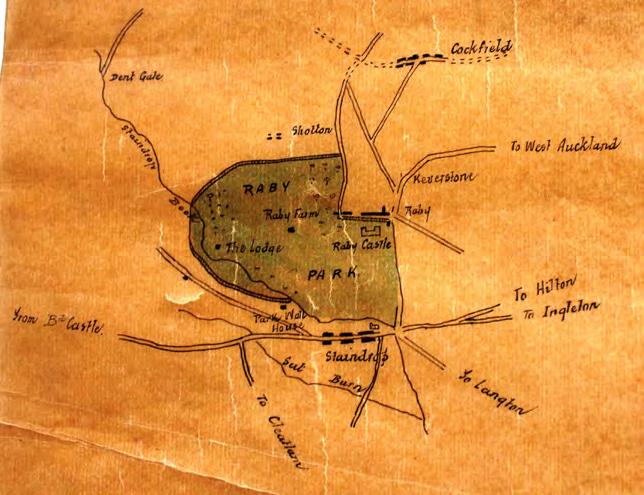
Another map within the Raby Castle archives is very similar and may be a copy of the Sayer and Jeffry’s map.

53 UNDERSTANDING HISTORICAL DEVELOPMENT
R Sayer and T Jefferys map of The county palatine of Durham (http://biblio.unibe.ch/web-apps/maps/zoomify.php?pic=Ryh_1810_49. jpg&col=ryh)
Map of Raby park, 1768
Contents
1760–1820: George III
1770
1771
Carr converts the old stables at the Castle to a Servants Hall. He also adds a floor to Joan’s Tower and may also have enlarged and Gothicised the Garden House. It is likely that not long after, the new stables and coach house were constructed in Raby village. Carr’s original design for the stables show he originally intended it should have a crenellated parapet though the existing classical block displays the same massing and has the same door details.
The Staindrop to Raby turnpike road is diverted further east, extending the boundary of the Park. A map from this period shows the proposed route of the new road. The line of the old road can still be traced as earthworks running south across Raby Park.
c.1770

Map of c.1770 showing the proposed route of the Turnpike Road further east of Raby Castle.

54 UNDERSTANDING HISTORICAL DEVELOPMENT
Unexecuted design by John Carr of Raby stables, coach house and gateway
Contents
1760–1820: George III
1774
1774
An Act of Parliament was obtained to divert the main road to Cockfield, allowing more parkland to be created north of the castle. This was to signal the end of Old Raby village.
Around this time John Carr designs all the post-road lodges.
Thomas White proposes an ambitious scheme for the Park involving canals, islands and lakes. An alternative design for a walled garden and associated buildings was also included. Whilst most of the scheme remained unexecuted, two ponds to the south of Home Farm were created and Lady Wood was planted in the early nineteenth century. The ponds south of Home Farm have since disappeared and exist only as marshy ground.


north.

55 UNDERSTANDING HISTORICAL DEVELOPMENT
Plan of Raby showing the old line of the road to Cockfield, and the line of the new road further
Contents
Details of White’s unexecuted landscaping proposal for Raby Park
1760–1820: George III
1781–1785
Land to the north of Staindrop originally entailed away, is purchased by the Earl from the 2nd Viscount Vane. The 2nd Earl of Darlington was, therefore, able to re-unite the Park and complete the Park walls and ha-has. The Low Lodge was also completed about this time and Byre House is believed to have been Gothicised by Carr.
North Wood folly is completed by John Carr.
John Carr remodels the entrance hall to the Castle.
1780 1775 1792
1786 1787 1789
Raby village is finally cleared away. New Raby had been under construction for several years to the east of the turnpike road.
The white Ischia Fig tree in its specially built house on the south terrace was bought to Raby from Italy by his son (later 3rd Earl of Darlington).
John Carr roofs over the circular drawing room. The 2nd Viscount Vane dies without issue.
1760–1820: George III
1806

William Harry, 3rd Earl of Darlington succeeds.
The Prince of Wales (George IV) and Duke of Clarence (William IV) visit Raby. The Princes Room is decorated for their stay which lasts a week.
56 UNDERSTANDING HISTORICAL DEVELOPMENT
Contents
Raby Castle c.1780s with Raby village in the foreground prior to its removal
1760–1820: George III
1812 1814 1810
Lady Wood is planted.
Landscaping of southern end of the Park is completed. The estate is recorded in a map by John Dixon (with dated amendments).

Interior alterations to south range by Joseph Browne take place and the dining room received Chinese decorations and new fireplaces.
1820–1830: George IV 1837–1901: V ictoria 1830–1837: William IV
1827 1833
The Earl is created Marquis of Cleveland.
The 3rd Earl of Darlington was created Duke of Cleveland. He laid the present coach road through the Park, although it now deviates from its earlier more eastern route. He extended the Ladywood at the southern end of the Park. He also planted Northern Wood between Raby and Cockfield, and smaller woodlands to provide cover for game. His successors changed the Park very little.
1816 1842 1843
A new cottage is built near Bath-House.
Henry, 2nd Duke of Cleveland succeeds.
1845 1844
William Burn is invited to survey the castle. As a result, he extensively remodels the building between 1844 and 1850.

New pine pits are established for cultivating pineapples.
New stone for borders of the West Garden Rose gardens were established.
57
DEVELOPMENT
UNDERSTANDING HISTORICAL
NINETEENTH CENTURY
John Dixon’s plan of Raby Estates from 1812.
J. C. Buckler, South and west fronts, Raby Castle, 1817, one of a set of three views of the castle by Buckler preserved recording the castle after the eighteenth-century restorations.
Contents
1837–1901: V ictoria
1847 1864
The orchard within the Walled Garden was dug up to provide room for the vineries. The glasshouse to accommodate vines along the north wall of the gardens was built around this time.
1856 Ordnance Survey map, published 1860
1856
The estate is first accurately depicted on the 1856 Ordnance Survey map, published in 1860.
William, 3rd Duke of Cleveland, but in September of the same year he died and was succeeded by his brother Harry, 4th Duke of Cleveland.

58 UNDERSTANDING
DEVELOPMENT
HISTORICAL
Contents
1837–1901: V ictoria
1894 1891 1896 1850
Duke Harry dies with no male issue. As a result, the Dukedom and titles, except for Barony of Barnard, become extinct. Raby passes to Henry de Vere Vane, 9th Lord Barnard, who traces his descent from Morgan Vane.
The 9th Lord Barnard plants trees in the Park and Lady Barnard constructs a driveway through the centre of the Bath Wood.
The wrought iron gate installed in the South Terrace, given to Lord Barnard by the owner of Fairlawn, Mr Cazalet.
A gas-works was established at Raby Castle in 1850, with Staindrop supplied from a newly established gas company in 1854.
The estate is again depicted on the 1896 Ordnance Survey map, published in 1897.

Although there are largely few changes since the 1856 OS map was published, the eighteenth century dog kennels are shown to have been replaced by Kennel House.
The gas house is depicted for the first time.
1899
An improved Fig tree house is built twelve feet longer than the original. It was later rebuilt in 2007.
59 UNDERSTANDING HISTORICAL DEVELOPMENT
Contents
1896 Ordnance Survey map, published 1897
The Duchess’ Handbook for Raby Castle
The Duchess of Cleveland, Catherine Wilhelmina Powlett (1819–1901), was the only daughter of Philip Henry Stanhope, 4th Earl Stanhope (1781–1855), and married into the Vane family in 1854. Her husband, Harry (1803–1891), succeeded to the dukedom in 1864. The Duchess was a writer, historian and genealogist, who was best known for The Battle Abbey Roll with some Account of the Norman Lineages (1889).

She was also responsible for compiling a guide to Raby Castle. The Handbook for Raby Castle gives a detailed account of the history of the castle, description of the interior, exterior and of the estate. It also provides a fascinating insight into the plantings of Raby Walled Gardens in the 1860s. She usefully describes it as follows:
The kitchen garden is in front of the stables, and contains all the flowers to be found in the place. There are, indeed, nearly as many flowers as vegetables, some parts of the garden being wholly given up to them. There is a rose garden, two fine old yew hedges, and two grand walnut-trees overhanging a small circular fountain; the green slope above is divided by great raised flower-beds, and a ribbon border guides you from the garden gate to the conservatory. In front of this is a mass of parterres in elaborate geometrical patterns, brilliant colour till the frost come (sometimes very early) to blacken them.
The glass houses were an important feature of the gardens. She says there is altogether a great deal of glass in the garden; first the long row of new vineries built by Duke Henry against the upper wall, then two ranges of peach houses, to one of which a vinery is added; nine pineries, a fig house, and an azalea house, built by the present Duke.
The conservatory was also built by Duke Henry ‘and contains some large orange, lemon, and citron trees that have been here for nearly forty years, some tree ferns, &c., but the finest plants are in the stove – merely two former pineries now converted to this use. Here there is a good collection of orchids and tropical plants which are a never-failing delight to me’.
During the nineteenth century, the grapevines had been a particular feature for visitors to Raby:
The old vineries stood against the lower wall (near the present conservatory), and contained some celebrated vines, which, unfortunately had to be sacrificed to the change; but the new ones will soon take their places, as they now bear very well.
The famous Raby fig is also mentioned by the Duchess:
The fig house is occupied by one single tree, originally brought form Spain by Lord Darlington in the last century, and now covering 52ft if wall; it bears delicious, small, white figs.
The Duchess mentions the problem of the northern climate:
The winters are severe, and no tender plant will live out of doors…Laurels flourish well enough, but there are no laurustinus or arbutus, and some araucarias planted behind the garden seem to remain in statu quo. There is, however, a bay tree doing well in a sheltered corner of the wall. The climbing roses are sometimes killed down to the ground by frost, but the standards and tree roses, when a little protected, do well… We are very proud of growing the Souvenir de la Malmaison, which will not live at Auckland Castle…
No peaches are grown out doors, and the walnut trees very seldom bear; but there is an abundance of apricots, plums, cherries, apples, &c. and after a fine summer I have seen magnificent pears, but they are not generally speaking, large.
The Duchess also provides a description of the stable yard. By the 1860s she was already mourning their declining use and condition:
The stables are rather extensive, forming a long range looking south, with a separate court for loose boxes. I remember them full of hunters in Duke Henry’s time, and now there is not one; their present condition would move Nimrod to tears if he could revisit them. The ponies alone date from these sporting times; for I grieve to say my beloved Tommy and Billy are very old…There are also great coach-houses, built in the days when guests came in their won carriages, instead of the family omnibus, or a fly from the station; – all very useless now.
Above the stables are rooms for the stable servants, and one very large room, formerly used for storing meal for the hounds, has, with an adjacent one, been fitted up as footmen’s bed-rooms.
Of the Riding School she says: The riding school is large and dark, with small unglazed windows on each side; no horses are ever exercised there now...’
Other buildings are also mentioned:
The stud groom’s house (now occupied by one of the watchmen) stands at the entrance of the stable yard, and is one of the two houses that now remain of the old village of Raby. Behind are the cow-byres and pigsties; further yet the raff-yard – as it is always called in the North country –where the carpenters, masons, and blacksmiths belonging to the estate have their workshops and stores. The clerk of works has a house at the end of this yard.’
60 UNDERSTANDING HISTORICAL DEVELOPMENT
Contents
The 4th Duchess of Cleveland
Contents
1901–1910: Edward VII 1910–1936: George V
1914 1901
The interior of the chapel is restored by J P Pritchett.
The Ordnance Survey Map of 1914 shows only minor changes have taken place on the estate and within the Walled Gardens and Stable Yard.

1914 Ordnance Survey Map, published 1921
1910–1936: George V 1936: Edward VIII
1936–1952: George VI
1930s–1950s
During the 1930s to the 1950s the Gardens were altered by the wife of the 10th Lord Barnard. Lord Barnard also established further clumps and plantations in the Park. The East and West Gardens were planted in part by fruit trees. In the East Garden a path, bordered by a long sweeping fuchsia hedge, divided the upper part of the Garden, which contained the Peach House (taken down in1945) and species trees in a rhomboidal bed, from the lower, which was planted with plum and cherry trees, each in its curved flower bed. Against the
East wall were planted pear trees, some of which still survive, while a shrub border grew against the South Wall. The East Garden contains the main herbaceous border designed by the wife of the 10th Lord Barnard, with planting within the lawn including the tulip tree and the Wedding Day Rose.
In the Central Garden, low yew hedges were planted after 1920. The Summer House was also designed around this time. A masonry lion was mounted on
1917 1918
The heir to Raby, Henry Cecil, is killed in the First World War.
Raby passes to Christopher, 10th Baron Barnard.
the wall leading to the East Garden and in the centre of the border, above the central pond, a lead cistern was placed. The cistern is believed to have come from Cleveland House, the family’s London home.
The West Garden was filled with fruit trees and the long North border was replanted.
61
UNDERSTANDING HISTORICAL DEVELOPMENT
TWENTIETH AND TWENTY-FIRST CENTURY
1936–1952: George VI
1952-Present: Elizabeth II
1964 1966
Raby Castle and estate is captured in a number of aerial images which show the extensive planting of the gardens, particularly vegetable production, and the extensive number of glasshouses.

1952-Present: Elizabeth II
1947 1975 2016
1977 1985 1999
The 1:2,500 Ordnance Survey is a reflection of the estate in late twentieth century. There are fewer greenhouses today than shown to have existed in 1975.
The main Kitchen Garden was removed to its current site and lawn laid with only soft fruit trees remaining in the West Garden.
Behind the path of the Long North wall, a new border and lawn were planted after the removal of the cold house. The glass was removed from the Pine Pits and Vineries behind the potting shed, but the foundations remain.
Much of the gardens were re-designed for ease of management and visitor access. Plans for the East garden were produced by Dr Francis Johnson, FSA, but are not yet adopted. Most new work was confined to Central garden where the Victorian conservatory was replaced by a smaller one in the same style.
New features of the formal Rose Garden, the informal Heather and Conifer Garden, curved brick walls and urns designed by Mr. Connell of Reavell and Cahill of Alnwick.
Henry (Harry) succeeds as the 12th Lord Barnard.
Much of the East Garden remained in Victorian taste until death of 10th Lord Barnard. He was succeeded by Harry John Neville, 11th Baron Barnard.
The Walled Gardens were remodeled. The fuschia hedge and fruit trees were removed and the lawn laid with small beds. The fruit trees in the West garden were also removed and replaced by a Kitchen and Market Garden, the produce being sold locally.

62 UNDERSTANDING HISTORICAL DEVELOPMENT
Raby Castle 1947 (Britain from Above)
Contents
Raby Castle Walled Garden 1947 (Britain from Above)
3.3 M AP PROGRESSION
The following map progression focuses on the Walled Gardens and stables area. It presents dated and undated maps for completeness, offering observations on potential dates and commentary on features to assist in our understanding of the history and development of the area. This section represents the first time, a photographic record of the Raby Castle archival materials such as maps and plans has been made available for readers to corroborate assessments of phasing. The order of images within the document does not claim to be absolutely accurate but has nonetheless provided enough information to date individual structures to within decades of construction. Where assumptions are made, these have been identified as such as any gaps in knowledge are identified and stated within the text. An emerging research framework has been provided in Section 6.3 of this Conservation Plan.
1729
These dated plans are of the estate as surveyed by George Dixon in 1729. They show Raby village (left) and on the adjacent plan, the Castle with moat, prior to its landscaping. Orchards and gardens are to the north-east and west of the castle on the north facing slopes. The field marked 20 is a similar shape to the present walled gardens which has led to the assumption that this plot was later adapted on the south-facing slope.


63 UNDERSTANDING HISTORICAL DEVELOPMENT
Estate Plan by George Dixon
Estate Plan by George Dixon Contents
N N
UNDATED
Shows a design for a ‘new stables’ and ‘offices’ to the north-east of the castle. Raby village is laid out on the north side of the road. A kitchen garden is shown to the north-west, and north of this are ‘cart houses and stables in the town’. The plan is likely to have been drawn before the 1750s when it is assumed the gardens were laid out.

64 UNDERSTANDING HISTORICAL DEVELOPMENT
Undated design for new stables and offices Contents
N
C.1750
The Walled Gardens are believed to have been laid out during this period. An undated and unsigned plan, which may date to this period, shows the basic plan form and other features which are evident today. Hot walls are incorporated in the design but only a short stretch in the north wall. The north and south walls were made of locally hand-made bricks. Areas for melons and pineapples are indicated, with green houses and hothouses in the centre of the back wall. Three ponds or basins are shown, of which the central pond still exists the others may not have been constructed. The main entrance to the Gardens was in the east wall. There is no indication that the yew hedges were part of the plan.
In the west gardens, where the Gardener’s House stands today, is a ‘Magazine’, whilst the gardeners house is located in the east garden. This may have been an unexecuted design, but the presence of a Magazine was mentioned in the estate account books at this time.

65 UNDERSTANDING HISTORICAL DEVELOPMENT
N Contents
Undated Plan of the Walled Gardens thought to be by Thomas Wright or Joseph Spence.
UNDATED (ASSUMED 1770s)
Assumed by Alistair Rowan to be c.1749,01 this plan shows the proposed Raby to Staindrop road in its present location. The road was diverted by Act of Parliament in 1771, suggesting the plan is later than assumed, but before Raby village was removed in the 1780s. The gardens are formally laid out, with an oval fountain or pond in the central garden overlooked by a rectangular building with an irregular shaped yard behind. Other buildings shown are an ‘L’ shaped structure in the location of the hunting stables, and the Gardeners House. Note that the Stable and Coach house is not shown. An earlier form of Raff Yard (a maintenance yard) is shown beyond the village.

66
DEVELOPMENT
UNDERSTANDING HISTORICAL
01 A Rowan, The Gothick restoration of Raby, Architectural History 15:
1972
N Contents
Undated map of ‘Raby Castle with Part of the Park’
1812
The estate is recorded in a map by John Dixon (with dated amendments). The Walled Gardens are shown with the existence of two linear structures along the north wall. A smaller version of the Gardeners House with associated out building is also in place. The Raff Yard, stables and Coach House, hunting stables, the hay barn, and a smaller Raby Park House are also shown, as is Byre House and barn. The Riding School is not shown. The orchard is a feature of large areas of the complex.

67 UNDERSTANDING HISTORICAL DEVELOPMENT
N Contents
Detail of John Dixon’s plan of Raby Estates from 1812
UNDATED MAP OF RABY (ASSUMED 1830S)
This detail of plan thought to date to c1830 is a schematic plan of the wider estate and less focused on the Stable Yard and Walled Garden. The Riding School and a range of buildings to the east of Raff yard are not shown. Note the Gas Pipe to Raby Castle, which was installed in 1850 from a newly established gas works. The gas house does not yet appear to have been constructed.
Undated plan of Raby Estates, possibly 1830s-1850s.

68
DEVELOPMENT
UNDERSTANDING HISTORICAL
N Contents
TITHE MAP OF THE TOWNSHIP OF RABY CUM KEVERSTON, 1839
This dated plan of 1839 shows an important addition since John Dixon’s 1812 plan. The hay barn is shown again and a Riding School has now been constructed north of the coach house range and additional structures attached to the south are shown. These are not depicted on any other plans. Of a little less significance, the piggeries have been added to the yard north of Byre House.

69
DEVELOPMENT
UNDERSTANDING HISTORICAL
Plan of Township of Raby cum Keverston, 1839 Contents
N
PLAN OF THE TOWNSHIP OF RABY CUM KEVERSTON, 1842
Separated by only 3 years, the 1842 plan is less schematic than the John Dixon and the 1839 Tithe Map and shows additional changes to the site. Buildings are shows along the north wall of the gardens, whilst many more outbuildings are indicated in the yards behind. Raby Park House has received a westerly extension and Raff Yard, its eastern projection. To the south of this is an extension to the rear of the cattle byre attached to the Dutch barn. For the first time, the paths of the Walled Gardens are shown, and what may be the yew hedge is suggested in the central garden. The Fig House also makes its first appearance and the Gardeners House has a rear projection to the west.

70
UNDERSTANDING HISTORICAL DEVELOPMENT
Plan of theTownship of Raby cum Keverston, 1842 Contents
N
1856 ORDNANCE SURVEY MAP, PUBLISHED 1860
The Ordnance Survey Map, First Edition, is believed to be an accurate record of the site from this period. Although surveyed 14 years after the previous plan, it shows many subtle differences. Of note are the addition of glasshouses, and possibly the pinery, in yards north of the Walled Gardens. Gardens have replaced the orchard to the west of Raff Yard, and a new range of buildings has been constructed along the north wall of the complex. A new pathway is shown in the West Walled Garden and the Gardeners House has a further ex tension to the rear on the east side.


71 UNDERSTANDING HISTORICAL DEVELOPMENT
1856 Ordnance Survey Map Detail of gardens and stable yard complex, 1856 Contents
N N
UNDATED PLAN
This undated plan is of the Walled Gardens and stables area probably dates to the latter half of the nineteenth century, but before the 1896 OS Map. However, the plan is problematic; whilst is shows some buildings as conceived in the later nineteenth century, such as the Gardeners House with is extensions, the large number of glasshouses, the extensions to the byre east of the Dutch barn, and extension to Raff Yard, are missing from this plan. It is possible the plan is incomplete, or that the draftsman was unconcerned with the yard (here described as ‘Raft Yard’). Another explanation, though unlikely, is that the buildings were demolished and reconstructed in the latter half of the nineteenth century. The yew hedges are clearly shown, along with paths laid out within the gardens.

72 UNDERSTANDING HISTORICAL DEVELOPMENT
Contents
Undated plan of the latter half of the nineteenth century.
N
UNDATED DRAINAGE PLAN, C.1890
A drainage plan from c.1890 usefully depicts the names and uses of various buildings with the stables area. The Riding School is labelled as the ‘Riding Shed’. The cottage in Raff Yard is labelled ‘Office’ and the barn north of the Gardeners House is labelled ‘Bath House’. The stables to the north-east of the stables and Coach House is labelled as a Byre, with a Slaughter House to the south, and Calf House and Bull House to the northern end. Drawn up by North Eastern Security Inspection Association of Newcastle Upon Tyne, the business was incorporated in 1889. The lack of the motor garage shown on later maps indicates this plan was drawn up before the 1896 OS map was surveyed. Detail of the building uses shown on this plan are articulated on the Historic Uses plan on page 85.

73 UNDERSTANDING HISTORICAL DEVELOPMENT
N Contents
Sketch Plan of Drainage (south to top of plan) stables and Outbuildings, Raby Castle (nd)
ENVIRONS OF RABY CASTLE, 1893 BY W
LIVESEY,
CLERK OF WORKS
The estate was recorded again in 1893. Although there is little obvious change between this and the undated drainage plan, this plan provides additionally information about the layout of the Walled Gardens and of the wider complex, including building uses. Of particular interest is the design of planting within the Central Walled Garden. These historic uses inform the plan on page 85.


74
UNDERSTANDING HISTORICAL DEVELOPMENT
Contents
Detail of Environs of Raby Castle, 1893
1896
The Walled Gardens and stables area is again captured by the Ordnance Survey in 1896 (published 1897). The 6-inch map provides more detail than the earlier plan of 1856 but shows relatively few major changes have taken place in the intervening years although various outbuildings have been extended or added. Of note, however, is the addition of the Motor House, without its glass canopies. The new entrance and pathway within the south wall which had been installed in 1894 is shown.


75 UNDERSTANDING HISTORICAL DEVELOPMENT
©
46
u D H M
m m m m m o w m
100020449
1896 Ordnance Survey Map. Ordnance Survey (c) Crown Copyright 2014. All rights reserved. Licence number
N Contents
Detail of 1896 Ordnance Survey Map showing the gardens and stable yard complex. Ordnance Survey (c) Crown Copyright 2014. All rights reserved. Licence number 100020449
N
1914
The Ordnance Survey Map of 1914 shows only minor changes within the Walled Gardens and stables area, the largest change being the introduction of a further access point into the complex from the west, which is not shown on the 1896 OS map. A number of small glasshouses have been added, the glass canopy has been built against the Motor House. Raff House has been extended and has glazed porches to main entrance and kitchen door, and a conservatory or glasshouse against the south elevation. Additional tree planting is indicated to the east of Raff Yard and within the grounds of Raby Park House.

76 UNDERSTANDING HISTORICAL DEVELOPMENT
N Contents
Detail of 1914 Ordnance Survey Map showing the gardens and stable yard complex. Ordnance Survey (c) Crown Copyright 2014. All rights reserved. Licence number 100020449
1975
During the twentieth century there was no significant new buildings added to Walled Gardens and stables area. Rather, it saw the gradual decline and loss of structures including the Victorian conservatory which has since been replaced with a smaller example.
The 1975 reflects the opening of Raby to the public with the addition of public conveniences north of the piggeries.

77 UNDERSTANDING HISTORICAL DEVELOPMENT
N Contents
Ordnance Survey Map showing the Castle gardens and stable yard complex. Ordnance Survey (c) Crown Copyright 2014. All rights reserved. Licence number 100020449
3.4 R ELATIONSHIP OF LANDSCAPE TO STRUCTURES
The Parkland associated with Raby has a history of change in scale, purpose (be that associated with agriculture or for pleasure), as well as the alterations of key landscape features. These landscape features have a direct relationship with the landscape character found at Raby. The following maps identify landscape features/structures found historically within the parkland that have altered and therefore cannot be understood within the current setting.


A A further series of ponds similar to those located to the immediate setting of Raby Castle were located south of Home Farm. These were designed by Thomas White.
B Boat House historically located on the northern banks of Raby Castle’s High Pond.
KEY LANDSCAPE FEATURES
Parkland Boundary 1914
Current Parkland Boundary
Lost Landscape Features/Structures
Lost Historic Routes
Additional Landscape Features which change the landscape character
This plan is not to scale
Map 1, showing the wider parkland boundary beyond the Registered Park and Garden

78 UNDERSTANDING HISTORICAL DEVELOPMENT
N A B
West Lodge
Keverston Lodge
Old Lodge A B N
Contents
KEY LANDSCAPE FEATURES
Parkland Boundary 1914

Current Parkland Boundary
Lost Landscape Features/Structures
Lost Historic Routes
Additional Landscape Features which change the landscape character
This plan is not to scale
79
UNDERSTANDING HISTORICAL DEVELOPMENT
Map 2, showing the current Registered Park and Garden boundary A B D C E G F H N Contents
A: North Wood
Two unnamed buildings and two ponds located north of the folly are illustrated on the nineteenth century maps.


The immediate setting to the folly was designed to be open to the south.
The central route through North Wood was historically wider.
B: Keverston Lodge

Keverston Lodge was located at the far eastern corner of North Wood.
C: Drive to West Lodge
Several tree clumps run along the Estate road parallel to the Terrace Walk.
D: Route to Gas House Wood

The setting to North lodge was previously more open.
Additional woodland south of North Lodge has changed its character and restricts views. The angular edges to the new woodland are uncharacteristic of earlier planting.
The route running from the stable complex eastwards was historically not a formal tree avenue but randomly spaced parkland trees.
E: Terrace Walk
The route of the Terrace Walk has altered alignment over time. The 1st edition OS 1860 shows the route running in front of the Pavilion.
80 UNDERSTANDING HISTORICAL DEVELOPMENT
A B
C
D
Contents
E
F: Middle Lodge
Middle Lodge historically sat east of the Parkland along the road known as Keverston Bank (A688) and had a series of smaller routes which encircled the surrounding pocket of woodland.
G: Bath House
Two circular routes were located immediately south and south-east of the Bath House.


Two unnamed buildings within the pleasure ground setting were historically located just off these routes.
One of these structures may have been an aviary.
H: Lady Close Wood
A tree Nursery located just north-west of South Lodge is illustrated on the 1st edition OS 1860.

81 UNDERSTANDING HISTORICAL DEVELOPMENT
F
G H
Contents
3.5 H ISTORIC ROUTE ANALYSIS
3.5.1 H ISTORIC APPROACHES
There are two entrances from Keverstone Bank: South Lodge, with a lodge and stone gate piers (listed Grade II), from which a drive runs north-west 01 , and North Lodge (John Carr, listed Grade II) with paired gothick lodges from which a drive runs south-west to the Castle 02 .

Two more entrances with lodges on the south side of the site and outside the registered area are accessed from Moor Lane. Ladywood Lodge is a simple stone cottage and West Lodge is a cottage of 1914.
Approaches from the south side of the site enjoy impressive views of the Castle across the lakes.
South Lodge was previously the main entrance, providing views of the castle towers, until a sharp incline cuts off the view. On reaching the summit of the incline the castle is seen again, an imposing view with the lake in foreground. From here, the carriage drive went through an avenue of old beech trees to reach the Porter’s Lodge. The 3rd Earl of Darlington laid out the driveway from South Lodge, although it previously had a more eastern alignment 03 to take advantage of views from the ridge when travelling by carriage.
Old West Lodge is situated to the west of Home Farm (outside the Registered Park). The present Old Lodge Farm occupies the site of the house just south of the Old Lodge.
In addition, Keverston Lodge was located at the eastern edge of North Wood.
3.5.2 W IDER LANDSCAPE HISTORIC ROUTES
The landscape contained numerous routes connecting structures and views, many of which have been lost.
These include:
• Sinuous, winding routes through Bath Wood 04 . A Serpentine Walk in the centre of Bath Wood was planted with rhododendrons and was the width of the whiskey carriage, on display in the stables.
• The route to Middle Lodge from the Castle 05
• A footpath connecting Bath Wood with the Terrace Walk 06
• A footpath along the eastern park boundary 07
• The routes within North Wood 08 were generally more direct and created to ease the transport of ore from the lead mines in North Wood. There was a wide track through the centre of North Wood connecting Keverston Lodge, the Folly and Shotton farm buildings.
HISTORIC ROUTE ANALYSIS
Lost since 1st edition, 1860 New since 1st edition, 1860
Surviving since 1st edition, 1860 Lost since Dixon Plan, 1812
This plan is not to scale
82 UNDERSTANDING HISTORICAL DEVELOPMENT
N 01 06 02 08 07 03 04 05
Contents
Extracts of the 1860 OS map showing details of historic routes


N N
Extract from the 1st edition OS map 1860 illustrating routes through Bath Wood. Ordnance Survey (c) Crown Copyright 2014. All rights reserved. Licence number 100020449 N N

Extract from the 1st edition OS map 1860 illustrating routes through wood around Middle Lodge. Ordnance Survey (c) Crown Copyright 2014. All rights reserved. Licence number 100020449
Extract from the 1st edition OS map 1860 illustrating routes through Gas House Wood. Ordnance Survey (c) Crown Copyright 2014. All rights reserved. Licence number 100020449
Extract from the 1st edition OS map 1860 illustrating the designed setting for The Folly. Ordnance Survey (c) Crown Copyright 2014. All rights reserved. Licence number 100020449
83 UNDERSTANDING HISTORICAL DEVELOPMENT
07
08
Contents
04
05
3.6 P HASES OF DEVELOPMENT
3.6.1
WALLED GARDEN AND STABLES AREA
The plan on this page set out the overall historic development of extant buildings within the Walled Gardens and stables area, based on primary archival research and site investigations. The evidence base that has informed these plans can be found in Section 3.3 The phases of development (and significance plans) should be updated as understanding improves in the future.
PHASES OF DEVELOPMENT
A ssumed c.1750
A ssumed remodelling of earlier building c.1770s–1780s
Assumed 1770s–1780s Assumed 1780s–1812 1812–1856 1856–1896 1896–1914 Modern
A Appears on undated plan of c.1771–1786 as ‘L’ shaped. Probably rebuilt B On an eighteenth century base

This plan is not to scale
A B
84
UNDERSTANDING HISTORICAL DEVELOPMENT
N
Contents

85 UNDERSTANDING HISTORICAL DEVELOPMENT Potting Sheds High Vinery High Garden Shed Workshops Raff Yard Cow Byres Residential Of ce Hayshed Fold Yard Riding School Stables Coachhouse Stables East Garden West Garden Glasshouses Grass Garden Early Peach House Store Room Residential Shed Calf Shed Bull House Calf House Byre Byre Slaughter House Shed Bull House Residential Bull House 18th Century Hunting Stables 19th Century Low Stables Musroom Sheds Pine Stoves Plant Stoves Conservatory Bothy Early Range Joiner’s Shop Pigsties Cart Stables Of ce Fig Packing Shed Smithy Bathroom Early 20th century Residential Tool Shed 4 1 2 3 4 4 HISTORIC USES AND FUNCTIONS Garden Service Yard Garden Production Stables Farm Residential Nineteenth Century Access Modern Access Only, not in use prior to 1914 (OS map) Lost Building NOTES: Stables and Gardens were often accommodated in close proximity due to the ease of moving manure from the stables/ cows to the gardens. This plan is not to scale N Contents
Raff Yard is a northern term for a maintenance or service yard, particularly associated with timber. It would have served both the Walled Garden area and the Castle.
Its functions included a blacksmiths, joiner’s shop and other estate workshops. An office and house associated with the Estate Manager are found here.
Formal gardens to south and north served by glasshouses and offices, with substantial staffing levels.Glasshouses were often single function and had heated walls to support production of exotic plans (peach house; vinery for grapes; ‘early range’ for propagation; ‘pine stoves’ were for cultivating pineapples; and mushroom sheds. The Bothy was a small shelter for the garden workers.
Garden function was very much divided between the ‘display gardens’ with cultivation spaces for high-status plants and those functional/productive areas that serviced these behind the scenes.
The stables accommodated the expensive horses that served the Estate. These ranged from high-quality hunters and carriage horses to cart horses.
The building housing the family’s coaches was high status when constructed in the eighteenth century but was little visited by guests by the 1870s.
The riding school to the north was probably only ever used for exercising horses in a clean environment, rather than to showcase fashionable dressage skills that developed in the mid-eighteenth century.
Upper floors of these buildings were used for accommodation e.g. grooms, and large open spaces may have once been sub-divided or used for storage.
Access was from three points possibly serving 01 stables; 02 farms; 03 gardens. There were three additional pedestrian access points 04 .
Clear divisions existed between garden and stable areas with no east/west circulation. The division between farm and low-end stable functions blurred to the north-east. Raff Yard remained a clearly defined space of two courtyards.
Farm areas were for cattle and pigs on the inner estate, serving meat and dairy to the Castle.
Cow Byres provided accommodation for cows, calfs and bulls. A slaughter house served the Castle and a substantial hay barn fed the animals. The fold yard is a place where cattle were enclosed.
86 UNDERSTANDING HISTORICAL DEVELOPMENT
Contents
3.8 C ONTEXTUAL ANALYSIS
3.8.1 PARKS, GARDENS AND WALLED GARDENS
Before the eighteenth century, gardens and parks were designed both for pleasure and the cultivation of vegetables and herbs, and would have contained structures such as walls, arbours, follies and foundations. Some 3,000 medieval deer parks are recorded, and usually lay in open countryside, enclosed by pales. By the early eighteenth century, garden fashions were moving away from the rigid order of formal gardens, and long, designed views became important, which led to the introduction of the sunken wall and ha-ha. Temples, ruins and statues appeared as eye catchers and the short-lived fashion for curved Rococco features were popular. Historic England has observed that ‘Such landscape parks are reckoned among England’s most important contributions to European civilization’ 02
By the mid-eighteenth century informal landscapes evolved rapidly, largely due to the influence of Lancelot ‘Capability’ Brown. As at Raby Castle, huge numbers of landscapes were transformed and laid out with pasture, undulating grounds studded with clumps, plantation belts to screen villages and new lakes devised to resemble rivers. The whole was enclosed within a tall wall, punctuated by entrances with gatekeeper’s lodges (appearing from the later seventeenth century). Kitchen and formal walled gardens also multiplied at this time as technological developments in propagation and horticulture expanded the range of what could be cultivated.03 02

Whilst the new landscapes were of interest, owners also wanted areas to walk, and shrubs/flowers to provide interest. The influence of Humphry Repton c.1800 led to raised terraces and flower beds or urns, with lawns, shrubberies and architectural features such as summerhouses. Gardens became more formal again in the second quarter of the nineteenth century, and Coade stone was frequently used for statuary.
Walled kitchen gardens supplied the house with vegetables, fruit and flowers. The tall walls created a micro-climate, but at Raby, would have also protected the produce from the deer. These gardens were southfacing and the north walls were heated with a complex system of flues and associated boiler houses. Walled gardens were productive, bustling and energetic spaces, that demonstrated horticultural showmanship and the power and status of the owner. These were innovative places where new techniques were applied, and exotic edible plants cultivated, often at considerable cost and requiring great skill. Earlier walled gardens in the mideighteenth century would have been a talking point and delight for guests, but by the nineteenth century they were being screened from the main house as merely productive areas. Raby is therefore unusual in that it remained in situ, in full view of the Castle gates.
Generally, the gardener would have lived on site in a spacious house, and from the 1840s the range of glasshouses expanded as glass became cheap. This was certainly the case at Raby and the increased use of glasshouses is clearly shown in the Ordnance Survey maps during the nineteenth century and twentieth century.
Structures within parks and gardens were either for pleasure or utility. Within the Walled Gardens and stables area, the majority are for utility, with statuary, formal planting and landscaping providing the pleasure. However, functional structures essential to maintenance were often embellished architecturally to allow discerning visitors to be shown around. At Raby, the Gardener's House, Byre House and stable block were all ‘Gothickised’ to form a coherent ensemble. Elaborate gates, piers, fencing and walls are all found at Raby, controlling access into and within the landscape.
Landscape structures such as deer houses were usually of high architectural quality as they also acted as eyecatchers. At Raby, kennels and associated house were also of high-quality, and are a typical element of high status complexes, providing facilities for foxhounds as this became popular in the early eighteenth century. Examples pre-dating the 1850s, as at Raby, are of national significance.
87 UNDERSTANDING HISTORICAL DEVELOPMENT
Historic England, Rural Landscapes: Register of Parks and Gardens Selection Guide, 2018, 10 03 Ibid
Turner’s view of Raby Castle and the Park (first exhibited 1818)
Contents
3.8.2 G ARDEN STRUCTURES
The discovery and introduction of exotic plants to Britain in the seventeenth century dramatically increased the desire to cultivate these rarities and ingenious methods were invented to do so.04
Gardeners embarked on a period of experimentation in which trial and error played a large part, even in the design of the structures they built. The Orangery came first and citrus fruits were cultivated in England from the mid-sixteenth century against south-facing walls or within sheltered galleries.

The eighteenth century again saw a new range of exotic plants introduced, many of which needed warm conditions all year round to achieve optimum growth. These included figs and pineapples such as at Raby Castle. The Dutch are credited with developing the
glasshouse as we know it today in the 1680s. This was a lean-to arrangement with glass casements sloping from the south wall to the ground. These became known as hothouses, a term applied to both those that were artificially heated but also cooler glasshouses or conservatories.
The hothouses were often heated by a serpentine flue that ran through the brick back wall that led from a firegrate at the bottom of the wall to a chimney at the top. The initial hot air flues were not ideal as there was a danger that they would leak fumes into the house and it was also difficult to maintain a constant temperature. At Raby Castle, the remnants of hot walls, boiler houses and glass structures remain, but there is no single intact arrangement. Survivals are often rare due to the lightweight construction of the structures and their constant evolution. The walls generally survive better than the glasshouses due to their sturdy design.
3.8.3 B ATH HOUSES
The mid-eighteenth century is associated with the creation of open ‘natural’ parkland. Pleasure grounds did continue to be created and maintained in this period but they were usually hidden away from the main façade of the house, as with the Bath House landscape at Raby. They featured curvilinear, relatively narrow gravel paths, which ran through areas of grass and shrubbery planted with varying densities of trees. The paths usually provided a circuit walk, mirroring the circuit drive within the park. A wide variety of flowering shrubs and flowers were planted and built structures were added to give ‘delight’, such as miniature bridges.
Bath Wood is a thickly wooded valley, with winding walks and drives that all terminated at the Bath House (1752). In front of the bath house was an open lawn:
“well laid out with rhododendron beds and single specimens of conifers, with a lake-stream of water winding its way in various falls and artificial forms. This open space, or lawn, is thickly surrounded with grand old beech and spruce-fir trees, blending most charmingly together”05
There was a Kentian stream with rustic rock-work bridge, probably by Robinson. There is also a 1750s plan of a menagerie in Bath Wood designed by Carr which was probably not executed.

88 UNDERSTANDING HISTORICAL DEVELOPMENT
05 T he Stately Homes of England
, 2013
04 Fiona Grant, Glasshouses
Walled garden and glasshouse at the Museum of East Anglian Life, Stowmarket (© Snapshooter, Flickr, 2013)
Contents
1750s Sketch plan of the intended Menagerie in Bath Wood (not executed)
3.8.4 PINERIES
The introduction of the pineapple drove the design of hothouses and glasshouses more than any other exotic plant. The first pineapple was successfully grown in the Netherlands, in the late seventeenth century. By the eighteenth century this skill had transferred to Britain and the pineapple became a major status symbol for the wealthy and skilful gardener. The first pineapple was successfully grown in England between 1714 and 1716 by Sir Matthew Decker.
Pine pits were the crucial feature within a Pinery; these were shallow beds in which pineapple plants were placed, in pots, and surrounded by a layer of tanners

oak bark and mature. A description of 1781 suggested that a pine stove should be between 12 and 14 feet in width in order to allow for a large central bed about 6 to 8 feet wide. These beds were usually higher at the back than the front in order to provide a sloping surface paralleling the roof of glass above.06 The pineries could be any length from 20 to100 feet, depending on the amount of pineapples being grown. Welbeck Abbey had a pine stove 250 feet long. The design for Raby Castle’s pine pits survives and is thought to date to the at least the 1850s. Although no longer visible above ground, there may be remnants surviving below. Many country houses are known to have cultivated pineapples but very few survive in anything like their original condition.
Until the 1850s Pineapples were grown on a threeyear cycle. After the crowns had rooted in the first year they were transplanted into a ‘succession bed’ to be grown in the second year before being moved to a final ‘fruiting bed’ in the third. It was not uncommon to have three different structures for each of these stages although smaller estates were often split into two separate sections, divided by a partition and individually heated to different levels. The latter appears to have been the case at Raby Castle.

By the mid-nineteenth century hot water systems were being used instead. Boilers were installed next to the furnaces in a back shed and pipes would have run in a circuit at the bottom of the pits.
Pineapples were still exhibited at horticultural shows in the 1900s but by the twentieth century imported fruits started to arrive in good condition. From the 1950s onwards pineapples were grown so that they fitted neatly into a tin and of the 52 varieties listed in 1835, only two remain in cultivation today.
89 UNDERSTANDING HISTORICAL DEVELOPMENT
Plans for cold house and pine pit in the Walled Gardens at Raby Castle, n.d
Elevation and plan of Pinery cum Orangery, John Walter, 1809, Glasshouses, Fiona Grant, 2013. Pineapples were often cultivated with vines above then, as shown here, to provide shade.
Ibid
06
Contents
3.8.5 S ERVICE BUILDINGS
Agricultural and Farm Structures
The patterns within the landscape can often be traced back to historic land use and settlement from at least the medieval period. At Raby, radical and wholesale enclosure, village clearance, parkland redesign and road diversions have had a major impact on the legibility of the landscape prior to the 1750s.
Within the landscape, the farmstead is the main focus of both the domestic and agricultural buildings. This complex of buildings can include a farmhouse, buildings for the housing and processing of crops, storage of vehicles, implements, fodder and accommodation for livestock. Buildings can be multi-purpose and specialist in their function. The relationship between the farm and the farmstead was rationalised in the seventeenth and eighteenth century, with a desire to unify and integrate functions, particularly after 1750 as farmers looked to increase productivity.
The agricultural revolution of the second half of the eighteenth century saw investment into new types of stock, crops, buildings and land management, coupled with enclosure of open fields and moors or heath. The 1750s to 1880s was the most important period of
farm building development in England, and from the 1790s the era of ‘High Farming’ saw investment in new scientific measures and principles that led to more rational use of buildings. Earlier local and vernacular styles made way for architect designed structures, pattern books and gentrification. The designs by Paine at Raby of the ‘ideal’ farmstead (Raby Hill House) are an example of this movement. At Raby Estates, the home farm was to the west of the Castle and has always remained in hand as the estate farmstead. The farm structures integrated into the stables area were used to serve the immediate needs of the Castle with meat and dairy.

The general farmstead types, which were clearly distinct by the late nineteenth century, included the courtyard plan, the linear or L-shaped plan and the dispersed plan.
Raff Yard
The maintenance and service buildings of Raff Yard were developed to support the immediate Estate of the Castle and the extensive stables area. An earlier form of the site existed within Old Raby village but in a different location. It would have included timber and lumber yards, masons and blacksmiths workshops, sheds and other maintenance spaces. The term Raff Yard is one

particular to the north of England and refers to a works or maintenance yard.07 They held the joint function of maintenance yard with blacksmith, farrier, joiners and masons alongside the farmstead functions that served the Castle and incumbent family cattle for dairy and meat, pigs, horses for work and transport, and gardeners.
The Dutch or Hay Barn
Hay barns were recommended for use at the end of the eighteenth century and the early years of the nineteenth century as a method to protect hay which was easily spoiled, particularly in wetter climates. Ventilations were a key feature. Dutch barns differed from French barns in the permanence of their construction. Hay barns rarely appear on farms as permanent buildings after the1860s.08 Barns of this size in the north of England are fairly rare and are usually associated with the housing of large numbers of cattle over winter. At Raby, it is likely that the hay also served the extensive stables. Hay barns, the predecessors of Dutch barns, are fairly common in the western counties of Herefordshire, Shropshire, Staffordshire, and Cheshire where pastoral farming and dairying predominated in the nineteenth century. Most are of relatively late date late nineteenth century making Raby’s version that much more significance. Of interest is also the integrity of the hay barn and the
limited evidence of changing use over the decades. A similar example can be found at Croxdale Hall, near Sunderland Bridge, County Durham.
Cattle Housing
The byre or cow house was for the accommodation during the winter for animals too precious or insufficiently hardy to winter in the open. This was dependant on the amount of fodder available. Very few cow house interiors of the nineteenth century or earlier have survived unaltered because of changes required to meet hygiene regulations for the production of milk. The byres at Raby are unusual for the survival of fabric and fittings including flooring, partitions, feeding troughs and hay racks.
Pigsties
Pigs were kept on most farms but little evidence for pigsties survives even in dairying areas, save in Cheshire and Staffordshire, as pigs were often left to run in yards amongst the cattle. The pigsties at Raby originally had small enclosures on the south side of the piggery which have since been removed. As with many other examples, the ones at Raby have been largely adapted for other uses.
07 C atherine, 4th Duchess of Cleveland, A Handbook for Raby Castle 1870, p205
08 RW Brunskill, 1999, Traditional Farm Buildings of Britain, pp101–102
90 UNDERSTANDING HISTORICAL DEVELOPMENT
Paines’ design for a farmhouse intended for Raby
Contents
Hay barn at Croxdale Hall (Roger Smith)
3.8.6 E QUESTRIAN BUILDINGS
Stables09

The noble display of the horse was a critical function of country house stable design from the medieval period to the nineteenth century and was at least as important as its practical management. Due to the value of horses, stables have always been well built, placed near to the house and of a certain level of architectural treatment. Stables needed to be well ventilated with plenty of light for grooming and harnessing. Historic stables are generally normally two storey buildings with a hayloft above and the horses stalled across the building, with a central door between two windows along one side. Stables associated with high status houses were usually the most architecturally refined.
The Evolution of Medieval and Early Modern Stables
The stables buildings themselves were visually set apart from the other service buildings through their quality of materials and design. Windows were glazed by the late 16th century but few stables were stylistically innovative before the end of the Jacobean period, with stalls, arcading, racks and mangers as common features. Evolution in stable technology occurred from the seventeenth century onwards lies mainly in the introduction of a new, expensive breed of horse which merited greater comfort than existing breeds:
• Partitions between horses were unusual before the seventeenth century but were common by the eighteenth century.
• Hay racks evolved in the seventeenth century to make it easier for the horses to eat and keep the dust out of their eyes and drainage was also improved at this time, with stone or brick paving and drainage gullies.
• Saddle rooms were also an important space, providing storage but also display or harnesses and other trappings.
• Hay could be stored above the stables or in a separate building within the complex.
• Coach houses began to be built, initially as a roofed structure with open sides.
Part of this revolution in design was to do with haute école, which was a new courtly fashion for riding horses in displays rather than in the traditional military form and was first popularised in this country by Henry VIII. The introduction of the coach or carriage, common by the end of the sixteenth century was also an important factor.
Classical architectural features and styles were adapted for stables from the 17th century onwards, including use of the oeil de boeuf window for the hay lofts. The first surviving detailed drawing of a stable dates to 1658, for Welbeck Abbey by Robert Smythson. The stable was vaulted in stone (to protect against fire), heated chambers for grooms and harnesses, running water to remove waste and ventilation shafts for the horses. It had alternating round and segmental pediments over the windows.
Eighteenth Century Onwards
Post-Restoration stables were often elaborate and were often miniature versions of the contemporary country house. Early on, these could be placed in a wing flanking a house but later, were placed with other offices and services to one side. Most stable courtyards lacked unity and included a variety of buildings including barns, coach house, laundry, brewhouse and even farm buildings. Little changed in design until the early eighteenth century, when Palladian stable quadrangles became more popular, and is thought to relate in part to the changing practices brought about with hunting horses and the rise of foxhunting. This increased dramatically in the second half of the eighteenth century, as thoroughbred hunters and racing developed.
• Stables and coach houses were treated as independent structures until the eighteenth century but were later integrated.
• In the seventeenth century, the timber partition between the horses became common, often with elegant sweeping curves and classical heelposts.
• Hay was generally kept above the stables in the eighteenth century and stables moved away from the house in an attempt to avoid the smells.
• Handsome interiors were created to showcase the horses, and sometimes included classical columns, cornicing and stone vaulting.
• L arge timber partitions and hay racks were replaced in the later eighteenth century by ironwork as this became more readily available.
• Clinker brick flooring became common.
Thoroughbred, racehorse and hunter triggered a second revolution in stable design in the late Georgian period 1790s–1830s, as horse prices rose. The most significant innovation was the introduction of the loose box. These could be 10ft square or more, enclosed on all sides allowing the horse freedom of movement. Before the 1800s, a few loose boxes were available for foals and sick animals only. Hunting stables were increasing fitted out with loose boxes and were often designed to impress.
Growing concern regarding ventilation and drainage continued although early solutions for ventilation were experimental and not entirely successful. The eighteenth century saw the length of the stall increase as standards rose in general.
It should be noted that increased popularity in hunting also required other service buildings. A design in Robert Lugar’s The Country Gentleman’s Architect of 1807 described a design for kennels, hunting stables and cow yard.

91 UNDERSTANDING HISTORICAL DEVELOPMENT
09 Worsley, The British Stable, 2004
The stables and rising school at Wentworth Woodhouse, designed by John Carr
Contents
Stables and Riding House of Edinburgh Academy 1763 by Robert Adam
Riding Schools10
Covered spaces for equestrian exercise and sports date from the mid-seventeenth century when the schooling of horses or haute école was becoming fashionable. These buildings were constructed for the training of horses in the art of Manage, a practice similar to modern dressage. The Riding School at Bolsover (Grade I) is a grand rectangular, double-height building with upper and lower rows of windows and a suspended ceiling, and rather unlike the example at Raby Castle. Another example was built in the early nineteenth century for the Duke of Northumberland; it is also a long rectangular building of 28 bays set with Diocletian windows along each wall. The distinctive cast-iron truss roof structure enabled the roofing over of a wide span unencumbered by columns.11
The Rise of Early Modern Riding Houses
Riding schools or houses were substantial covered spaces used for the exercise and training of horses and were one of the largest independent structures associated with the country house. They were one of the first buildings built specifically for a single sport (along with tennis courts) and were built for practicing haute école and the training of both horses and riders. The practice originated in Naples and was swiftly taken up by Henry VIII in the early sixteenth century. It was originally practiced in open manages but were soon replaced (in London initially) with riding houses. The first riding school was probably built in 1611 for Prince Henry as part of wider improvements. The building was a freestanding rectangle of approx. 40ft by 120ft, built in brick with a simple gable and buttresses, and minimal architectural detail. The interior was well lit, and the windows were hinged for ventilation. A viewing gallery was heated by a fireplace. The practice of haute école declined following the Civil War and no riding houses are known to have been built for a century following this (up to the 1740s), with horse racing and hunting becoming popular instead.
Eighteenth Century Onwards
After the 1750s and up to the 1780s, riding houses saw a revival, with fourteenth known to have been constructed in this period, built for devotees of haute école, although as possibly is the case at Raby Castle, some were built as a covered area for exercising horses in bad weather.
Many later riding houses were built for utility not for show, and all by men who had a passion for horsemandship (this was not a building type considered an essential by most), for example William Cavendish at Welbeck Abbey. Apart from the first Royal examples, the majority were plain buildings, and few were placed for architectural effect, often located at the back of the stables. Design and decoration was usually determined by their function, with plenty of indirect light and easy access. Few had ceilings or were plastered. They rectangular, 40ft wide or larger, and about three times as long (dimensions of 3:1 were common but 2:1 was also found), Many had an attached open manege for outdoor practice. There is a possibility that Duchess’ Walk at Raby Castle took on this function as an enclosed outdoor space for gentle exercise for the hunters and carriage horses.
Some examples of riding houses of interest include:
• Riding School for St James Palace, London, Robert Smythson, 1611, 42ft x 124ft

• Castle Ashby, Northamptonshire, 1610s, 35ft by 70ft
• Petworth House, Sussex, 1610s

• Syon House, not built
• Welbeck Abbey, Nottinghamshire, 1623
• Bolsover Castle, 1630s
• Grosvenor Square, Benjamin Timbrell, 1728, 86ft by 40 ft
• Raby Castle Riding School, late eighteenth century, 32ft x 210ft
• Caulke Abbey, Derbyshire, 1760
10 Worsley, The British Stable, 2004’
11 https://historicengland.org.uk/listing/the-list/list-entry/1203779
Riding School, Halking Street London, c.1823
92 UNDERSTANDING HISTORICAL DEVELOPMENT
Riding Hall in Brighton by John Nash
Contents
3.8.7 A RCHITECTS AND DESIGNERS AT RABY
Daniel Garrett (d.1753)
Daniel Garrett was Lord Burlington’s personal clerk of works in the 1730s, assisting on a number of his project. Little is known of his early life and career. With Burlington’s patronage, he set up his own practise and is known to have work on the mausoleum at Castle Howard.
Whilst he was an exponent of the English Palladian style, his most important work being the design of Foots Cray Place in Kent (c1752) he was also adept at Rococo design as can be seen at Raby and at Temple Newsam. He also employed the Gothic style to work at Gibside in County Durham (1751), and also published a volume on farmhouse designs in 1747.
He died in 1753 in London and his practise was taken over by James Paine.12
Garrett at Raby
Garrett is thought to have designed the Dog Kennel, Bath House, the Gothic Pavilion, Home Farm and Raby Hill Farmhouse, as well as his work on designing a number of state rooms in Raby Castle as well as an apsed drawing room and the dining room behind it.
Thomas Wright (1711–1786)
Thomas Wright was both an astronomer, surveyor and a landscape gardener.
Born in Byers Green, County Durham, he was educated Dr Theophilus Pickering’s Free School in Gateshead probably in mathematics and navigation. He also studied instrument making and at the age of 20 set up a school to teach navigation and also sold instruments.
Wright later went on to lecture in astronomy; he also published a number of works on the subject the work he is most famous for is An Original Theory of the Universe published in 1750 which expounds the theory that the stars must be arranged in a disc or grindstone, an idea that would later be seen as a precursor to the work of William Herschel.

Having gained the patronage of Richard Lumley of Lumley Castle in Ireland in the 1730s, White was to become well known in aristocratic circles. His skills in mathematics and navigation saw him surveying country estates, and planning gardens and grottoes for aristocratic families. In 1755 and 1758 Wright published the first two volumes of Universal Architecture, the first containing six designs for arbours, and the second grottoes. The final volume on alcoves was never published.
Examples of his work includes landscape designs for Culford Park, Bury-St-Edmunds, Stoke Park, Stapleton and Lumley Castle. He also designed buildings including the stunning deer shelter in Auckland Park, Bishop Auckland.13
He died in 1786 at his childhood home and was buried at St Andrew’s churchyard, South Church, Bishop Auckland.
Wright at Raby
Wright may have been responsible for the laying out of Bath Wood and the Walled Gardens.
12 Peter Leach, ‘Garrett, Daniel’ in Oxford Dictionary of National Biography: https://doi.org/10.1093/ref:odnb/63115 Last accessed 0 6/06/2018
13 David Knight, Thomas Wright, in Oxford Dictionary of National Biography: https://doi.org/10.1093/ref:odnb/30060 Last accessed 0 6/06/2018
93 UNDERSTANDING HISTORICAL DEVELOPMENT
Thomas Wright, The Gentleman’s Magazine, 1793
Contents
James Paine (1717–1789)
James Paine was probably born in 1717 in Andover, Hampshire, the youngest son of a carpenter. He is believed to have studied architecture from an early age. It may be that following an introduction to Lord Burlington, he was made Clerk of the Works at Nostell Priory, Yorkshire. He received his first commission at this time for the Mansion House in Doncaster, launching his career as a designer of country houses.
He was an exponent of the English Palladian style, pioneering the Palladian villas a country house form, and also an early designer of Rococo interior decoration. His work epitomises the emergence of architecture as a profession working within private practises. This is also reflected in his variety of clients.

Whilst his work was mainly within Classical styles of architecture, he was employed on a number of projects where he employed the Gothic style. His work at Raby Castle and on another medieval building, Alnwick Castle, shows his willingness to keep within a style appropriate to the building. He also employed the Gothic style at Coxhoe Hall and Hardwick in County Durham, and at Ravensworth Castle the pointed hoodmould seen at Raby made a reappearance.
Paine at Raby
Baron Barnard commissioned Paine c.1752. The work mostly consisted of remodelling parts of the south and west ranges and some internal decoration. Whilst his internal designs tended towards the Classical, his exterior work was more Gothic. The external alterations included a number of conventional features such as arrow-slits and quatrefoils but there were also some rather individual motifs. The most frequent was a pointed hoodmould over a four-centre window. Other works at Raby are believed to have been the design for Home Farm, an architectural site screened by a castellated curtain wall, and a cottage which is a Gothic version of the familiar tripartite formula, with a crenellated pediment to the centre and a pointed hoodmould over the door.14 His work appears to have overlapped with Garrett on some site (such as Raby Hill House), possibly with them working in collaboration towards a final solution, although this cannot be proven.
1988, 135–144
94 UNDERSTANDING HISTORICAL DEVELOPMENT
14 Peter Leach, James Paine,
Contents
James Paine and Son by Joshua Reynolds
John Carr of York (1723–1807)
Was a renowned Georgian architect who was born in Horbury, the eldest of nine children. His father, Robert Carr (1697–1760) was a master mason and quarry owner, who is believed to have trained his son as a mason. However, it is known that by 1748, Carr began an independent career as an architect, working until shortly before his death. His early work is generally a mixture of Palladian and Rococo. He later sought a purer Antique Roman style with occasional French influences before adapting the style associated with Robert Adam. Towards the end of his career he returned to the bolder Palladian style of his youth but with detail that looked forward to nineteenth century usage.
Carr was chosen above James Paine to design a grandstand for the racecourse in his very first commission. His connection with York remained he became a freeman in 1757 and served as Lord Mayor of York in 1770 and 1785 as well as being appointed as a magistrate for West Riding.

His works include Harewood House, but his largest was the St Antonio Hospital in Oporto, Portugal. His work encompassed a variety of building types including public buildings, a prisons and churches. At Buxton he designed an early example of a multifunctional building which encompassed a hotel, lodging houses, A ssembly Rooms, shops, a post office and a public promenade all under one roof. His commissions for country houses included model farms, stable blocks, gate lodges, temples and other ornamental buildings.
Carr at Raby
The 2nd Earl of Darlington engaged John Carr to carry out improvements inside the Castle and on the Estate in 1768 including the creation of a carriageway through the castle from west to east, with necessary removal of ceilings and floors in the Great Hall and in Chapel Tower. Paine, who had worked there up to 1756, commented favourably upon Carr’s proposals in 1771 to restore the Great Hall, create a new south front and add new buildings in the south-east corner of the castle.
Much of his work was restoration, for which his approach was pragmatic. He dictated the general alterations on plan and left the specifics to the exact position of new doors and windows and the construction of passages to the masons. The executant mason under Carr was Mr Wing. For details Carr generally made the masons copy existing models at the castle (Wragg, John Carr of York, 193–194). A drawing by John Carr (signed twice) shows the proposed crenellated stables and coach house at Raby. Although not as yet executed, the existing classical block displays the same massing and has the same door details, raising the possibility that the building was reduced in scale, potentially by the Mr Wing.
Carr also designed a variety of lodges bridges and a D -shaped menagerie for Bath Woods. Few of his proposals were executed according to drawn designs. In 1770 Carr enlarged the Gardeners House in the walled garden with single bay, and single storey wings15
15 Brian Wragg, The life and works of John Carr of York, 2000, 193–194
Thomas White the Elder (1736–1811)
Thomas White the Elder was a designer associated of Lancelot ‘Capability’ Brown in the 1760s, who later set up his own practise. Much of his work was in Yorkshire, but his later work from the 1780s were almost exclusively in Scotland.
White is believed to have engaged by Lord Darlington during the late 1760s and early 1770s. An ambitious plan for Raby Park dated 1774 has been attributed to White, which involved the construction of sinuous canals, islands and lakes. Only a few elements of this plan came to fruition.16
16
190
95 UNDERSTANDING HISTORICAL DEVELOPMENT
D Turnbull, ‘Thomas White (1739–1811) 18th century Landscape Designer and Arboriculturist’, Unpublished Thesis, 1990,
Contents
John Carr by Sir William Beechey
ASSESSMENT OF SIGNIFICANCE
‘People may value a place for many reasons beyond utility or personal association: for its distinctive architecture or landscape, the story it can tell about its past, its connection with notable people or events, its landform, flora and fauna, because they find it beautiful or inspiring, or for its roles as a focus of a community.’01
4.1 C RITERIA FOR ASSESSMENT
Significance can be defined as the sum of the cultural heritage values or attributes that make a building or place important to this and future generations. The aim of conservation is to sensitively manage change to a place to ensure that its significance is not only protected, but also revealed, reinforced and enhanced at every possible opportunity.
Every historic place is different and the range of values or attributes that contribute to their significance therefore also vary. The range of values that may contribute to the significance of Raby Park within Raby Estates have been categorised under the following headings. These values are derived from Historic England’s Conservation Principles (2008) and the heritage interests in the National Planning Policy Framework (2012).
Historical Value: The ways in which past people, events and aspects of life can be connected through a place to the present. These illustrative or associative values of an historic asset may be less tangible than its evidential value but will often connect past people, events and aspects of life with the present.
Landscape Value: Value attached to natural environments as opposed to built structures. Heritage value may be placed upon include geology, ecology, arboriculture, horticulture and biodiversity. These could be designed on natural landscapes and can include the setting of and relationships to structures and designed or incidental views.
Archaeological Value: This derives from those elements of an historic asset that can provide evidence about past human activity, including its physical remains or historic fabric. These remains provide the primary evidence for how the asset has changed over time. It is the potential of a place to yield evidence about past human activity.
Architectural/Artistic Value: The ways in which people draw sensory and intellectual stimulation from a place. This might include the form of an historic asset, its external appearance and how it lies within its setting. Understanding the aesthetic value of an historic asset will be more subjective than the study of its evidential and historical values and will involve trying to express the aesthetic qualities or the relative value of different parts of its form or design.
Communal Value: This derives from the meanings of a place for the people who relate to it, or for whom it figures in their collective experience or memory. Communal values are closely bound up with historical (particularly associative) and aesthetic values, but tend to have additional and specific aspects; it can be commemorative, symbolic or spiritual.
LEVELS OF SIGNIFICANCE
The significance of Raby Park is assessed using a scale of relative significance ranging from High to Detrimental:
HIGH
A theme, feature, building or space which is important at national or international level, with high cultural value and important contribution towards the character and appearance of Raby Castle, Park and Estate and its setting.
MEDIUM
Themes, features, buildings or spaces which are important at regional level or sometimes higher, with some cultural importance and some contribution towards the character and appearance of the site and its setting.
LOW
Themes, features, buildings or spaces which are usually of local value only but possibly of regional significance for group value. Minor cultural importance and contribution to the character or appearance of the site and its setting.
NEUTRAL
These themes, spaces, buildings or features have little or no cultural value but do not detract from the character or appearance of the site its setting.
DETRIMENTAL
Themes, features, buildings or spaces which detract from the values of the site, its setting, character and appearance. Efforts should be made to remove or enhance these features.
4.2 A SSESSMENT OF SIGNIFICANCE
This section sets out the key values that contribute to significance at Raby Estates. These key values identified are those that must be conserved in order to sustain the significance of the place. Harm to these values has the potential to have a serious effect on significance and should be avoided.02 Significance is articulated as an overarching statement of significance in Section 4.2.1 then split between the five Historic England values in Section 4.2.2 Section 4.3 articulates significance visually on plans of the wider landscape and Walled Gardens area.
01 Conservation Principles, Policies and Guidance (Historic England, 2008).
02 In compliance with the guidance set out in the Government’s Planning Policy Guide (PPG)
96 SECTION 4.0
Contents
4.2.1 S TATEMENT OF SIGNIFICANCE
RABY PA RK
• Raby Park has high significance as a Registered Park and Garden of special interest (Grade II*) and for its listed structures (Grades I, II* and II) of special architectural and historic interest.
• The Castle has thirteenth century origins, associations with the Neville family and is one of the largest and most complete castles of its type in the country.
• The parkland was destroyed in a family dispute in 1714 but substantially reinstated as a picturesque deer park from the 1730s to 1780s. Much of this layout survives as a single phase design over a short period of landscape design of national significance.
• The landscape holds significance for its surviving designed and incidental views, its remarkable rural and tranquil qualities, and its important ecological characteristics.
• Significance lies in the integrity and authenticity of Raby Park, which remains largely unaltered beyond the eighteenth century.
• Key associations are with the Neville and Vane families, landscape and building architects Carr, Paine, Garrett, White, Wright and Spence, and the artist J.M.W Turner.
• There is high potential to understand more about the development and importance of the site through archaeological investigations.
• Communal value is increasing as the visitor offer, access and interpretation is enhanced.

• Significance will be sustained and enhanced through continued natural conservation works, on-going maintenance and repair of structures, reinstatement of historic routes or features and increased viability by returning redundant structures to beneficial use.
WALLED GARDENS AND STABLES A REA
• A s a coherent ensemble, the Walled Gardens and stables area holds high significance as part of the Registered Park and Garden of special interest (Grade II*) and for its listed structures (Grades I, II* and II) of special architectural and historic interest.
• Significance lies in the closeness of the Walled Garden and stables area with the Castle, and the visibility of these areas, which were often hidden away by the eighteenth century. This may have been a matter of display, to showcase the exotic plants, but was also a response to the evolution of the location of the medieval village of Old Raby as it began to serve the Castle in a more formalised way.
• The area was developed in the late eighteenth century and remains an intact and well-organised area developed to provide ancillary functions to support the family and immediate Estate:
o The Walled Gardens illustrate the importance of display and advanced horticultural practices within walled enclosures in the short period between 1750 and 1800.
o The stables are a focused, intact group of high-quality structures that illustrate the development of equine sport, transport and their use in the short period between 1750 and 1800
o The maintenance and agricultural buildings held the joint function of maintenance yard with blacksmith, farrier, joiners and masons alongside the farmstead functions that served the Castle and incumbent family cattle for dairy and meat, pigs, horses for work and transport, and gardeners.
• The Walled Gardens are highly visible from the southern carriage drive and the Castle, and feature in designed views, illustrating their highstatus and polite character.
• The Walled Garden and stables area have high evidential value. They were developed on the site of Old Raby and a series of ancient field boundaries, the complex takes its form from historic settlement and agricultural patterns.
• The Walled Gardens and stables both illustrate the evolution of the Country House and the structures put in place to support this. The Walled Garden is of particular significance in reflecting the keen interest of the 2nd Earl on horticultural innovation and newly introduced varieties of exotic plants and fruits.
• The number of surviving features within the stables and ancillary buildings are high and the whole complex is relatively intact. There is substantial group value is the ensemble of farm, equine, garden and maintenance structures.
o The stables and coach house are an important example of equine functions, integrated into one structure in the third quarter of the eighteenth century. Designed by a nationally significant architect.
o The riding school is a nationally rare example of a building type associated with a specialist use and connected to the rise in hunting and the expense of specialist animals. It dates to a peak in in the construction of riding schools but still a very limited number have been identified.
o The hay barn in an early example of this building type, and is rare for its architectural scale and design.
o The walls, glasshouses, boiler houses and remnants of garden structures have high illustrative significance and form a key group despite low survivals in some areas.
• The communal value of the Walled Gardens and stables area relates to its connections and value to estate workers, volunteers, tenants and visitors. However, the majority of spaces are redundant, declining and not accessible from the public visitor routes.
• There are opportunities to increase the aesthetic value of the area by introducing appropriate planting schemes, carrying out maintenance and repair to historic structures, and introducing new beneficial uses to redundant spaces.
97 ASSESSMENT OF SIGNIFICANCE
Contents
4.2.2 R ABY PARK
Evidential : Very High
Raby Castle is one of the largest and most complete castles of its type in the country. The Castle was not reduced or partly demolished like so many other houses and has an early fourteenth century core, with a licence granted to crenellate in 1379. The Castle was altered in the early seventeenth century and remodelled in the eighteenth century by Garrett, Paine and Carr. There is substantial potential to understand more about past human activity at Raby Castle, which increases evidential value. The exact form of the Old Raby village in particular is unknown, as is the historic layout and planting of the Walled Gardens and Bath Wood.
As archaeological investigations are carried out and more is understood about the place, evidential value will decrease as historical value increases. Some intrusive surveys may be required to further understanding, such as below-ground archaeological excavations.
Historical : Very High
Raby Castle was the seat of the Neville family from the thirteenth century and has associations to significant historic events. Cecily Neville (mother of Edward IV and Richard III) was born here and known as the ‘Rose of Raby’. It was used as headquarters during the Rising of the North (1569) and subsequently confiscated by the Crown. The site holds intrinsic significance for its continuity of ownership since 1626, when it was bought by Sir Henry Vane. It still remains in their family, and were created Barons Barnard of Barnard Castle by William III in 1698.
Ownership of the Estate by the Vane family has been fundamental to the Estate’s character. The Estate was stripped of its timber and deer and the Castle stripped of its furnishings and fittings in 1714 following a family dispute. Therefore, much of the Estates character relates to those changes made after 1723 by the second
Lord Barnard as he restored his inheritance. Today, it remains, and is managed as, a traditional working estate and family home, resulting in a well-conserved landscape, unchanged since the late eighteenth century with minimal influence from ‘modern’ activity.
Contributing substantially to its significance, the parkland retains a number of the eighteenth century landscape features, such as the main drives, High and Low Ponds, the Bath House, Follies and Walled Garden. The estate supports several landscape types that are nationally rare and important and are, therefore, the subject of UK BAP Priority Habitats. The management of the Park through grazing has continued to the present day and results in a landscape of high ecological value and exceptional aesthetic quality.
The Parkland and built structures are associated with some remarkable designers whose work was nationally influential have been associated with the development of the landscape:
• Thomas White the Elder (prepared plans in 1771 which may have been partially executed in particular two ponds to the south of Home Farm, the removal of ha-ha’s around the plantation and Terrace above High Pond).
• Joseph Spence (improvements to the parkland including removal of Raby village).
• Daniel Garrett (Dog Kennel, Bath House, Gothic Pavilion, Home Farm, Raby Hill Farmhouse)
• James Paine (Home Farm, Gothic Pavilion, Raby Hill Farmhouse)
• Thomas Wright (Bath Wood, Walled Garden)
• John Carr (stables and coach house, other partly executed plans)
The Parkland and Castle are illustrative of the evolution of large estates in this part of the country, as well as the modernisation from fortified Castle to family home. The interest in the landscape in the eighteenth century illustrates the wider interest in the picturesque, with J.M.W Turner painting the landscape in the early nineteenth century. Associations with hunting are important within the landscape and is illustrated within the high-status structures built for the hounds and horses.
Similarities to Raby Castle can be seen at Brancepeth, Bamburgh and Alnwick Castles locally and comparable to Bodiam in Sussex for its landscape setting and the Welsh castles for its completeness.
Aesthetic : Very High Raby Castle is listed Grade II* on the Historic England Register of Parks and Gardens of Special Interest. This puts the landscape in the top 40% of the c.1,650 landscapes on the Register as a landscape of national significance. The Castle is Grade I and is one of the largest and most complete castles of its type in the country. Much of the eighteenth century layout survives. Natural landscape features of significance include the collection of mature and veteran trees, which frame views and create a sense of scale and age to the park. The landscape is remarkably rural and tranquil in quality.
Dotted across the landscape are structures of historic and aesthetic interest, which are either functional or provide delight within the landscape sometimes both. Views from the southern carriage drive across the lakes towards the Castle are of the highest significance. Key views have been identified within the registered parkland and include both long and short distance, designed and incidental views. Many designed views look towards the Castle, but also look from the Castle towards Home Farm and the Walled Gardens.
Principal buildings include the Castle, north and south lodges, several follies, a bath house and several large farm houses. The Home Farm is outside the Registered parkland but has a symbiotic relationship with the landscape and is important within several key views. These structures add to the aesthetic qualities of the landscape.
Significance is eroded in places by the loss of several designed views and more recent dense planting. There are few modern encroachments either within the site or beyond it that have an impact on aesthetic value. During harvest, the requirement for large vehicles to access Home Farm via the northern parkland has an intangible impact on setting, sights and sounds.
Communal : Medium, with potential to be High The Raby Estate remains a traditional working estate and its connections with estate workers, volunteers, local residents, tenants and visitors contributes to the communal value of the landscape. In the early twentyfirst century, the parkland was generally inaccessible to all but the most determined of visitors due to short opening times and paid entry to the parkland. Since 2017, the family and Estate have been committed to creating a high-quality, authentic visitor destination, offering free access to the landscape and paid entry to the Walled Gardens and Castle. Communal value is increasing. Marketing, interpretation and facilities are currently limited but there are many opportunities for enhancement.
98 ASSESSMENT OF SIGNIFICANCE
Contents
4.2.3 R ABY CASTLE WALLED GARDENS AND STABLES AREA
Evidential : Very High
The Walled Garden and stables area have high evidential value and there is much to learn about past human activity on the site. In particular, the contribution of John Carr to the construction and remodelling of the structures, extent and form of Old Raby village, the planting of the Walled Gardens and the incorporation of ancient fabric into extant structures. Detailed research has not been carried out into the internal form of Raby Park House or Raff Yard House, both of which are sizable historic structures.
A s the site is better understood, evidential value will decrease as historical value increases.
Historical : High
As a group, the Walled Gardens and stables area is highly significant nationally. The complex is included within the Grade II* Registered area and contains several Grade II and II* listed structures. Developed on the site of Old Raby and a series of ancient field boundaries, the complex takes its form from historic settlement and agricultural patterns. The historic route through Old Raby is thought to run to the north of the stables along ‘Duchess’ Walk’ and Byre House possibly incorporates surviving remnants of the domestic structures.
The Walled Gardens and stables both illustrate the evolution of the Country House and the structures put in place to support this. The mid- to late eighteenth century date illustrates the specialisation of structures and spaces each providing a dedicated use from hunting horses to pineapple production.
Walled Gardens
The Walled Gardens at Raby Castle are of historical significance as an intact and early example of its t ype, which also retains its strong associations with the Castle. The gardens illustrate the importance of display and advanced horticultural practices within walled enclosures in the short period between 1750 and 1800. They form part of a wider, intact estate ensemble and pre-date the proliferation of productive walled gardens in the mid-nineteenth century (c.1840s).
The plan form is of interest, as although it represents a simple set of three squares, it has clearly been defined by the ancient field boundaries, visible in early eighteenth century plans. Retention of these slightly asymmetrical boundaries as walls is of interest. The survival of heated walls, boiler rooms, statuary, historic planting, such as the yew hedges, sheds, stores and the Gardener's House is of significance. Loss of the pine pits and other early glasshouses is unfortunate as these tell the evolving story of the site, however, one ‘Gothick’ glasshouse does survive in the central garden on the site of the previous glasshouse. The fig and its associated house to the south of the Walled Gardens is highly significance for its social history, and continued evolution.
Developed over two phases, the Walled Gardens were first laid out in the 1750s, replacing smaller gardens to the north-east of the Castle. The mid-eighteenth century date and the clear relationship between the Castle and the gardens assumes that these were formal gardens designed for display and pleasure, rather than merely productive kitchen gardens. An early proposed plan for the site shows a symmetrical layout with central glasshouse and hothouses, central water features, formal hedge planting and brick walls. The final design was slightly more natural in form, following the line of the previous field boundaries but still incorporating a Gardener's House. Glasshouses and associated hot walls would have been important components of the complex, where they would have been used to cultivate and display exotic species of fruits and flowers.
The Walled Garden is of particular significance in reflecting the keen interest of the 2nd Earl on horticultural innovation and newly introduced varieties of exotic plants and fruits. The calceolarias, rhododendrons and cinerarias planted at Raby were among the earliest to be grown in private gardens in Britain. Unfortunately, no early plans of the garden designs as built exist, although the historic yew hedges are distinctive and the fig tree beyond the walls is of particular interest.
The 4th Duke and Duchess were noted as collectors of rare plants, and the gardens were the subject of many articles in national journals such as the Journal of Horticulture. Plans for a pinery, which was shown as built on the 1850s OS map gives an indication of the interest the family took in cultivating rare and exotic species in the north of England.
To the north-west, ancillary gardener’s yards and productive gardens supported the more formal Walled Gardens. Developed in the late eighteenth and early nineteenth century, these were crucial productive elements for propagation and kitchen garden production. Much of the garden layout and lightweight structures have been lost of particular disappointment is the loss of the pine pits. There are opportunities in these area to bring back appropriate beneficial uses.
Stables
The stables are a tight, intact group of high-quality structures that illustrate the development of equine sport, transport and their use in the short period between 1750 and 1800, including the evolution of hunting as a new sport. The high-quality stables and coach house range, attributed to John Carr from the third quarter of the eighteenth century is high status and polite in its appearance. Deep stone window reveals and coursed rubble stone contend with Classical corbels and Gothick crenellations. Carr produced the initial drawing for the stable range, which was later reduced in scope and constructed by the estate architect. Nevertheless, the associations with Carr and the Castle are of high significance and the grouping of the coach house and carriage stable range with the other ranges for cart horses and hunting horses is also highly significant. Each stable block retains original and historic internal features that illustrate the status of their equine occupants and the methods for caring for them in the late eighteenth century. The harness room, upper accommodation and stalls within the main stable block are of interest, as are the loose boxes and ventilation provided to the hunting horses. The cart horse stables are proportionately lower in quality and opposite this is the cattle house.
The structure we know least about is the Riding School. Described as a riding shed in the nineteenth century, this structure does not conform to the typical form of a high-status structure used for the newly fashionable pursuit of dressage in the late eighteenth century. Nor does it seem wide enough to allow horses to exercise to any great extent. This long, narrow range was potentially for basic exercise for horses to avoid turning them out into the fields.
99 ASSESSMENT OF SIGNIFICANCE
Contents
Raff Yard
The maintenance and service buildings of Raff Yard were developed to support the immediate Estate, the Castle and the extensive stable complex. The term Raff Yard is one particular to the north of England and refers to a works or maintenance yard.03 The spaces to the north of the Walled Gardens and stables area include the earlier enclosed courtyard and structures of Raff Yard, adjacent to the later outer courtyard to the east. They held the joint function of maintenance yard with blacksmith, farrier, joiners and masons alongside the farmstead functions that served the Castle and incumbent family cattle for dairy and meat, pigs, horses for work and transport, and gardeners.
The maintenance and agricultural buildings are illustrative of an intact and well-organised area developed to provide ancillary functions to support the Castle and immediate Estate. Function is more formal to the south, merging into more back of house spaces to the north. The number of surviving features within the stables and ancillary buildings are high and include a complete nineteenth century forge, the weighbridge, pigsties and cattle byres. The larger structures had specialist uses, such as an unusually large and wellbuilt hay barn, the byre range associated with cattle, a forge and farmhouse, cart sheds and stores, slaughter house and bull house. An area named ‘Raff Yard’ was in existence in the early eighteenth century as part of Old Raby, but its layout and function is unknown and appears to have been in a different location. The ex tant structures are assumed to largely date to the 1770s, with the north-east ranges of the outer yard of a potentially mid-nineteenth century in date.
Related to the support of the Estate are Raff Yard House and Raby Park House, both of which are contemporary with the overall development date of the complex in the third quarter of the eighteenth century. These residential houses long been associated with the accommodation for the estate managers and architects.04
03 C atherine, 4th Duchess of Cleveland, A Handbook for Raby Castle, 1870, p205
04 Mr Garthwaite in the 19th century
Aesthetic : High
As a coherent ensemble, the Walled Gardens and stables area holds high significance both for the formal gardens, the stables and associated maintenance facilities. The grouping of these functions, along with Gardener's House, estate managers house and kitchen gardens, has created a tight group of spaces and structures that have high aesthetic value. Evolution has continued to define these spaces, as productive gardens and glasshouses have come and gone, and uses have shifted.
The space is characterised by its formal landscaping and gardens to the south which illustrate the scientificallyadvanced production of plants, fruits and flowers high-status equine care and accommodation to the east, ancillary maintenance and service areas to the north and accommodation for staff serving the Estate.
The Walled Gardens and stables area is clearly linked to the Castle itself, not just visually from its prominent location in the parkland, but through the symbiotic relationship servicing the Castle, the residents of the Castle taking pleasure in the garden spaces and the polite stable blocks.
The Walled Gardens are highly visible from the southern carriage drive and the Castle, including the inner yard, the lodge and some upper windows. Few windows face north towards the gardens but visibility from external spaces is extensive. The gardens were designed to be seen and no views have been lost in this area. The stables and other structures are visible to a lesser extent. The main stables and coach house attributed to the architect John Carr is brightly painted and its crenellations are eye-catching over the garden walls. The Gardener's House and Raby Park House are both visually dominant. Views from the north are less prominent, with boundary planting shielding the majority of the site.
There are opportunities to increase the aesthetic value of the area by introducing appropriate planting schemes, carrying out maintenance and repair to historic structures, and introducing new beneficial uses to redundant spaces.
Communal : Medium, with potential for improvement
The communal value of the Walled Gardens and stables area ranges from medium to low. Its connections and value to estate workers, volunteers, tenants and visitors is dependent on their level of interaction with the spaces. Visitors make use of the Walled Gardens and the main stable block as a shop and tea rooms, adding communal value. However, the majority of the other spaces are disused or in meanwhile use and are not accessible from the public visitor routes. Some key elements such as the hay barn are not visible and access is prohibited.
Since 2017, the family and Estate have been committed to creating a high-quality, authentic visitor destination and communal value is increasing. The visitor facilities are focused on this area and are open regularly during the summer season. Marketing, interpretation and facilities are currently limited but there are many opportunities for enhancement.
100 ASSESSMENT OF SIGNIFICANCE
Contents
4.3 S IGNIFICANCE PLANS
4.3.1
W IDER LANDSCAPE SIGNIFICANCE AND SETTING
This plan considers the relative significance of the landscape within the setting of heritage assets and in its own right as a designed asset.

WIDER LANDSCAPE SIGNIFICANCE P LAN
Raby Park Boundary
Very High Significance: areas of the highest significance relating to the principal heritage values and structures of Raby Castle High significance: areas forming the immediate setting to the Castle
Medium/low Significance: areas providing the immediate setting to listed buildings
Neutral Significance: areas not within key designed views, or where the character has altered over time, but not to the extent of detracting from the designed landscape and where there may be some capacity for change
Detrimental Significance: modern features / planting which are uncharacteristic of the historic landscape
Listed Buildings
I Grade I
II* Grade II*
II Grade II
The Registered parkland is Grade II* and is all considered to be of “more than special interest in a national context ”.
This plan is not to scale
101
OF
ASSESSMENT
SIGNIFICANCE
II* II* II* II II II II II II II II II II II I I Contents
N
LANDSCAPE C HARACTER AR EAS SIGNIFICANCE P LAN High Medium Low Neutral Detrimental
102 ASSESSMENT OF SIGNIFICANCE
This plan is not to scale Contents
4.3.3 WALLED GARDENS AND STABLES SIGNIFICANCE: STRUCTURES
N
STRUCTURES
SIGNIFICANCE P LAN High Medium Low Neutral Detrimental
This plan is not to scale
103 ASSESSMENT OF
SIGNIFICANCE
Contents
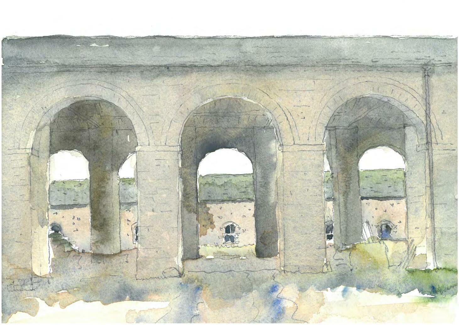
104 PART TWO CONSERVATION FRAMEWORK 5.0 Issues and Vulnerabilities 6.0 Principles and Recommendations 7.0 Capacity for Change 8.0 Next Steps Contents
ISSUES AND VULNERABILITIES
5.1 R ABY CASTLE AND WIDER LANDSCAPE
1. Built features generally: A continued decline in the condition of historic built features would impact upon their significance and setting of the Registered Park. Redundancy of wider structures is also harmful to significance through the impact this could have on condition. Individual issues relating to building features can be found in the management gazetteer.
2. Land management: Land management regimes may negatively affect natural diversity. These include arable farming regimes, heavy stocking of deer and inadequate woodland management.
3. Woodland Management: A decline in the condition of trees across the site may arise due to lack of/ inappropriate management or pests/diseases. Planted areas are becoming over-mature and footpaths are over-enclosed, with trees and shrubs having out-grown their surroundings.
4. Setting of the Registered Park: Unsympathetic development adjacent to, or within view of the Registered Park may compromise the value of the landscape. Any proposed development will need to be closely informed and shaped by their historic surroundings. The boundary of the Registered Park is under review and may be amended in the future.
5. Grazing: If the grazing stock is lost, or increased too heavily, the parkland character may be compromised.
6. Ecology and built features: It is likely that built features may support wildlife, bats in particular, that may be affected by repair work or new use.
7. Deadwood: This is an important resource and an essential habitat for many species, while at the same time a consideration in health and safety and presentational terms. The removal of deadwood and ‘tidying-up’ leads to relatively sterile conditions and takes away this essential habitat. An informed balance will therefore need to be considered ahead of any action taking place.
8. Access: Public access is currently confined to a small area of the Parkland and could be opened up further to visitors. Inclusive access is limited in some areas due to uneven surfacing. The potential impact of future visitors in terms of erosion and intrusion will also need to be balanced against new uses.
9. Circulation: Entry into the site via the North Lodge does not necessarily provide the best experience of the Castle and Parkland setting. Parking is currently at capacity and is inadequate for larger events. There is also a conflict between necessary farming activity and general use and access to the site. For example, the harvest is still carried out of the parkland via the shared trackways and North Lodge.
10. Parkland Trees: loss of parkland character through lack of future tree planting to replace mature trees once they die. Significant views would be weakened as trees framing these views are lost.
11. Fencing: Changes to fence lines may disrupt designed views and affect the open parkland character.
12. Views: Many designed and aesthetically significant incidental views are not part of the current structured visitor routes, which reduces their experience and understanding of the landscape.
13: Interpretation: There is limited interpretation to aid understanding of the wider landscape. Interpretation of the Castle and the visitor experience is now in need of refreshment as part of the main visitor focus for the new season and to enhance the quality and value of the present offer
14. Castle: Condition is generally good, however, a number of high-quality period rooms are in need of substantial conservation due to vacancy for many years. Improvements to services and infrastructure would be beneficial. Interpretation and presentation within the visitor routes could be refreshed.
15. Resources for conservation: Listed and unlisted heritage assets are of special architectural and historic interest and any repairs, alterations or reuse should avoid harm to this significance. Change should therefore be of the highest quality, which will increase the gap in funding between the cost of repair/reuse and the amount of revenue that could be generated. This is known as the conservation deficit, and is a risk to future uses. The optimum viable use should be found for heritage assets, and is the option that is economically viable but also causes the least harm to significance.
105 SECTION 5.0
Contents
5.2 W ALLED GARDEN AND STABLES
1. Condition: Many of the structures within this area were not included within the 2018 or 2013 QI and there is therefore only limited understanding of their condition. An initial visual assessment has found many to be in fair condition overall, with some redundancy and ‘meanwhile’ uses with repairs required. Those to the north are identified as being in somewhat worse condition, with moderate dilapidation, redundancy and need for substantial repairs. See plan on page 15 for more detail. Only the Laundry has been identified as being seriously dilapidated, requiring major works. Another concern is the declining condition of vacant upper spaces within many of the structures. Reuse, repairs and major works are required to improve condition, preceded by detailed condition and scheduling surveys to establish baseline repair needs, programming and budget costs.
2. Redundancy: Beyond the main stable block, the majority of structures within the study area are redundant or in basic ‘meanwhile’ use for storage. This redundancy puts the heritage assets at risk of further decline and the lack of use (including public access) does not reflect their potential cultural and commercial value.
3. Character and appearance: The character of each character area and structure has been assessed and identified as being sensitive to change. The vernacular and functional character of the elements requires careful consideration as part of proposals for regeneration. This is contrasted against the polite structures facing the Castle. New uses will need to understand the palette of existing materials, plan form, colours, features etc in order to incorporate new design in a sustainable way. The forge is an example of this, retaining an interior that would preclude many new uses, and many structures are linear in nature, which will demand creative design responses to ensure viability.
4. Existing uses: The Walled Garden and stables area is an intense and focused complex of heritage assets, contained within a tightly bound site. Future structural development will need to be contained within this area and careful thought given to the zoning of uses to avoid conflicts. Tenanted dwellings in particular may be at odds with other proposed facilities until circumstances change. Current use is restricted to the tearooms and shop, which have limited room for expansion due to the constraints of the historic internal features, boundaries and routes.
5. Setting and views: The setting and views to and from the Walled Gardens are one of its key assets. However, this prominence within the Parkland and its proximity to the Castle is a constraint as well as a virtue. The unusual dominance and proximity of the Gardens to the Castle underlines its significance and any new development or alterations should not adversely impact on key views.
6 Access and circulation: The Walled Garden and stables area is linear in character (east-west), with a single spine road running north to south, and another east to west. This original route of the Old Raby village road has been restricted to the west and has lost relevance, which could be returned. Routes run all around the boundary of the site and there is permeability to the north, but this is restricted by current uses. There are access issues with historic surfaces but also modern surfaces that are not in keeping with historic character.
7. Routes and parking: The car parking to the east of the site is visually intrusive in views from the Castle and the stables area. It is currently at capacity and is inadequate for larger events. Current access into the site is via the North Lodge, which does not provide the best experience of the views. Entry and exit via the same route also causes congestion, as noted within the context of the wider landscape
8. Interpretation: Existing interpretation within the Walled Gardens and stables area focuses on the carriages and the harness room. There is limited understanding of the gardens and their connections to the Castle, the maintenance yard or the stables. There is a lack of historic planting and understanding of this, and there is no visibility and activity of the garden maintenance team, which might be of interest to visitors. The redundant northern areas of the site are generally not accessible to the public and there is no interpretation to explain historic significance or use.
9. New development: New development within the Walled Gardens and stables area will be marshalled by the existing structures, their historic character and key views. There will also be archaeological implications of new structures, particularly on areas associated with Old Raby village. Lost structures within the area may provide exciting precedents for new development. Substantial works are likely to be required for conversion of many of the existing structures to viable new uses due to lack of infrastructure, services and facilities. Previous internal renovation of the residential dwellings (Byre House and Raby Park House) has not been sensitive to historic character and is detrimental to significance.
10. Viability and income generation: As designated heritage assets, there is a requirement to find the optimum viable use to justify their conservation, enhancement and future maintenance. This will require dedicated resources to make use of skilled craftsmanship, appropriate materials and achieve high-quality new design. Restoring these structures in a single phase or short period would represent the most substantial project within the Estate since the eighteenth century, which should be carefully considered. New uses will need to generate some form of income, in whole or in part, in order to sustain the future maintenance of the buildings and contribute to the health of the estate. Viability will need to be tested through market research and business planning alongside more comprehensive masterplanning at the next stage of the project.
106 ISSUES
VULNERABILITIES
AND
Contents
PRINCIPLES AND RECOMMENDATIONS
6.1 R ABY PARK: PRINCIPLES FOR CONSERVATION AND CHANGE
All change within the Raby Park will be informed by this Conservation Plan. This robust and proportionate understanding will ensure the potential impact of change is carefully considered against significance to ensure it conserves the key attributes of significance through repair, re-use, restoration or management, and maintains high standards of design quality and presentation. As business plans, visioning and market testing is carried out, management decisions will be based on an informed understanding of change. Proposals that undermine this understanding will be not acceptable in heritage terms, and in relation to statutory stakeholders. Care should be taken to ensure minor and incremental changes do not have a cumulative negative impact. Conflicts between different significance values, design integrity and biodiversity should also be identified and managed. Change required to provide beneficial new uses should be balanced against the possible harm to significance. Natural conservation and key views will be important considerations as part of the on-going management strategy.
A proportionate impact assessment will be carried out for future proposals to ensure that risks to significance are properly managed and understood, the impact of change objectively documented, and the consequences of implementation set out. Great weight will be given to the site’s conservation and any perceived harm will require clear and convincing justification (NPPF, paragraph 132). As a first principle, there should be a presumption in favour of avoiding harm to heritage.
6.1.1 PRINCIPLES
The principles, actions and parameters set out in this report should be used as part of an iterative design process to ensure an informed and engrained conservation and enhancement process is applied to the landscape and structures of Raby Park. There is no obligation for Raby Estates to carry out any of the actions that follow. These should be seen only as pragmatic recommendations that draw on conservation best practice and examination of the site.
Principle 1: All proposed change within Raby Park particularly affecting the listed buildings and registered parkland will be grounded in a robust and proportionate understanding of significance.
Principle 2: Changes to the landscape will balance traditional management against appropriate investment to sustain/enhance significance and promote sustainable public access.
Principle 3: As the setting of the highly-graded buildings, and as a designated asset in its own right, the Registered landscape will be conserved. An understanding of its relationship with the buildings will underpin decision-making.
Principle 4: Conflicts between significance values should be identified and resolved as proposals develop.
Principle 5: The impact of proposed change should be assessed to understand the benefits or harm to significance. Proposals that may cause substantial harm to primary significance values will not be accepted.
Principle 6: Proposals must respond to a clear understanding of significance, conservation constraints and design parameters.
Principle 7: Decisions about change should be reasonable, transparent and consistent. Early and regular consultation with key statutory bodies and stakeholders should be carried out.
6.1.2 R ELATIONSHIP BETWEEN THE CASTLE AND THE WALLED GARDENS
The Castle itself lies at the heart of the cultural significance and identity of Raby Estates. Until such future developments in the Walled Gardens and stables area and elsewhere become established, it will act as the primary visitor draw to the site from which secondary activity and revenue will derive. This scenario stems from a well-established model at other nationally important heritage sites across the UK and should be borne in mind within the context of further masterplanning and project development at Raby. On this basis, maximising marketing of the castle as an existing offer is essential, together with a focused appraisal of its current uses, capacity and future potential. This will ensure that the enhancement of the wider estate is co-ordinated with, and will gain maximum benefit from, its critical centrepiece.
Any future castle project may not necessarily need to figure early on in a site master programme, but should figure nonetheless so that it is closely factored into decision making. At the very least, new pressure is likely to be placed on the castle if visitor numbers increase as planned, this will need to be carefully managed, together with the likelihood that the Castle will temporarily need to act as the sole offer to visitors (and provide continuity of facilities) during the period of anticipated development in the Walled Garden and stables area.
107 SECTION 6.0
Contents
6.2 R ECOMMENDED ACTIONS BY THEME
These recommendations are relevant across the Estate and should be read in conjunction with the specific actions that apply to individual components, set out in Section 6.5. These actions provide guidance for when considering future development and are informed by conservation best practice.
THEME ACTION
Access 1 Ensure that any removal or reconstruction of circulation routes is preceded by an investigation and recording of any evidence of historic routes, width, build-up, wearing course and camber.
2 Establish a hierarchy of routes dependent on traffic volume and uses (with different widths, construction, wearing courses)
3 Consider implementing a one-way traffic flow for visitors across the site (e.g. from the South to North Lodge) that maximises the benefits of the dramatic designed views and carry out an assessment of new routes for farm deliveries and day to day management activities.
4 Begin discussions with the Highways department at Durham County Council regarding increased visitor traffic, entry and exit points and so on.
5 Carry out an assessment of potential future intrusion on the parkland and key vistas, and impact of pedestrians for any proposed new routes across the Parkland.
6 Seek to provide inclusive access to all public areas of the site. Where physical access may be deemed too harmful to significance or unsafe/impractical, other forms of access such as digital interpretation could be considered.
7 Carry out an audit of areas that could provide parking without causing harm to the landscape and setting. Consider providing several distinct areas of parking for different activities to disperse vehicle pressure across the site.
Circulation 1 Encourage people to explore more of the site, and to follow different routes, in order to augment visitors’ understanding and reducing footfall in focused areas, thus reducing the potential for irreversible damage.
2 Provide routes which visitors can follow depending on their interests, time availability and abilities.
3 Provide wayfinding to better allow visitors to experience the designed views, particularly of the Castle when approached from the south.
4 Improve wayfinding and pedestrian flow in the public areas between the parking and the Castle, including the route via the stables and Walled Gardens. Opening up routes north to south and east to west within the stables area would be beneficial.
THEME ACTION Management and use
1 The proposals for the development of Raby Park should align with the evolving vision for the site.
2 Periodically review the ongoing success of the management structure to ensure it remains as efficient and robust as possible.
3 Physical alterations to significant spaces within the building are likely to be required to create flexible new uses and any harm should be balanced against the benefits.
4 Ensure each post-holder is aware of their responsibilities and has the appropriate skills and training to carry out their role. Enlist external specialist advice when necessary.
5 Seek to broaden the cultural cultural and intellectual experience of the Estate.
6 Commission any additional surveys required to fully understand the Estate and the implications of change, for example baseline biodiversity study and arboricultural reports, impact assessments and access audit.
7 Continue to consider the boundary of the Registered Park and Garden with statutory advisors to ensure the protection it offers is commensurate with significance.
108 PRINCIPLES AND RECOMMENDATIONS
Contents
THEME ACTION
Built Structures 1 Ensure the recommended actions of the 2018 QI continue to be implemented.
2 Seek permission from statutory bodies prior to any alteration that will affect the special interest of a designated heritage asset and its setting, or the context of the Registered Park.
3 Significance of the buildings generally lies in their external appearance within the landscape and any surviving historic features. Both should be retained as far as possible in order to sustain key values.
4 Ensure proposals for change are based on a clear understanding of significance, proportionate to each structure’s special interest.
5 A recording exercise (to Historic England’s Level 3 or 4) should be carried out prior to major alterations or loss of historic fabric for listed structures.
6 A programme of long-term maintenance and repair should be implemented for all historic structures, as well as those excluded from the 2018 QI.
7 The principle of maximum historic fabric retention should be of the starting point for any proposals for change. Any change should respect the character, scale and massing of the current building, and its setting.
8 Any alterations or additions should be high-quality, of appropriate materials and craftsmanship and respect the existing setting and scale of development. This will have an impact on the cost of interventions.
9 Proposals for areas of the highest significance (such as listed buildings) should be based on trials and investigations prior to the project commencing, in line with good conservation practice.
10 New viable uses should be sought for built structures that are currently redundant or in ‘meanwhile’ use. Explore the possibility of moving maintenance and storage needs of the Estate to less conspicuous or less significant areas.
THEME ACTION
Walled Gardens and Stables
1 Prior to change within the Walled Gardens, a full assessment of the landscape should be carried out, including research historic planting, ecology, arboriculture and biodiversity.
2 Individual rooms, structures, features and landscape components should be assessed for a proportionate level of understanding of significance (to inform impact) prior to any proposed alteration, in line with national planning policy.
3 New uses should be sought for the redundant buildings and spaces in ‘meanwhile’ uses within the complex. Explore the possibility of moving maintenance and storage needs of the Estate to less conspicuous or less significant areas.
4 New uses should be sensitive to the historic building and should seek to reveal significance of architectural features.
5 Opening-up and sub-division may be justified by the creation of viable spaces but should be considered in relation to historic plan form and its significance.
6 The footprint of previous structures could provide precedents for new buildings, providing they respect the historic plan form and give grain and historic context back to the site. Characteristic features include long, narrow structures, use of tall boundary walls and vernacular architectural features. Polite architectural styles include Classical and Gothick models.
7 The removal of modern interventions, paint finishes, cementitious pointing and renders would be beneficial.
8 Recognise and plan for the need for new infrastructure, services and maintenance spaces as part of any proposals for development. These will have an impact on significance if not carefully planned at the outset.
9 Consider introducing new uses into this area that complement the focus of the visitor offer the stables, Walled Gardens and Castle. Ancillary facilities can be accommodated within less significant spaces, reducing harm to listed buildings.
10 Sustainable technology and methods should be used where feasible to enhance the performance of the buildings, enhance energy efficiencies and reduce carbon impact
109 PRINCIPLES AND RECOMMENDATIONS
Contents
THEME ACTION
Archaeology
1 Ensure archaeology above and below ground is considered as part of any proposals. The archaeological strategy within this Conservation Plan should be the starting point for any investigations.
2 Seek advice on whether below-ground disturbance will require archaeological investigation and agreement from the relevant statutory bodies.
3 Following consultation with relevant statutory bodies, commission targeted Archaeological Desk-Based Assessments and non-intrusive surveys as required.
4 Following completion of any works, evaluation and results of investigation will be shared amongst the professional and amateur archaeological community.
THEME ACTION
Landscape management, woodland and planting
1 Ensure any historic woodlands which reveal past patterns of management (for example, coppicing or pollarding) are once more managed in the same fashion.
2 All new planting should be carefully considered in relation to scale, colour and character of the trees or shrubs; dates of introduction; relationship to different styles of planting.
3 Veteran trees are an asset to the park and should be managed to secure their retention.
4 Replant specimen parkland trees using the 1st edition OS map as an initial guide to historic tree planting.
5 Create open clearings dappled woodland edges and margins are of importance for invertebrates, e.g. providing shelter and nectar sources.
6 Ensure that vegetation is maintained so that it deliberately frames/filters/hides/reveals views.
7 Potential to use the existing Longhorn cattle herd for conservation grazing within both the parkland and woodland.
8 Shift the balance away from timber production towards maximising environmental value and accessibility.
9 L ake management should continue is a regular programme of desilting and removal of algae.
10 Ensure any new agricultural boundaries do not disrupt key designed views. Consider replacing existing boundaries gradually with more appropriate estate iron railings which are less visually intrusive.
11 Grazing: the stocking rate of the deer should be carefully monitored, to check their impact on the ancient and veteran trees, for example, or their impact on historic landform.
12 Commission a tree survey including identification and significance of veteran trees.
13 Commission a baseline biodiversity study and recommendations, including identification of protected species.
14 Research any significant plants surviving, especially within Bath Wood, or any planting lists that could inform restoration of the garden. There is an opportunity to start propagating from any original cultivars
110 PRINCIPLES AND
RECOMMENDATIONS
Contents
THEME ACTION
Setting and views
1 Ensure views to and from the Walled Gardens are sustained and the prominent elevations external appearance of historic buildings are not heavily altered.
2 Ensure alterations or additions do not impact on views to or from the Castle and are subservient in scale, massing and respectful in materials to their surroundings.
3 Restore key vistas between structures and features through selective tree removal and crown lifting.
4 Views from the A688 are important but should to be selective, with careful screening along the rest of the road to minimise intrusion on the parkland.
THEME ACTION
Interpretation
1 Consider commissioning an interpretation plan to explore the narrative of the Estate and the stories that should be told. Focus on the Castle, Walled Gardens, stables/farm use, Parkland and bath house would be beneficial.
2 Recording should be carried out prior to change and particularly prior to any demolition within the Estate. An assessment of impact commensurate with significance is required to support proposals. This could form the foundation of interpretation for visitors and research purposes.
Community Engagement
1 Consider the creation of a Friends Group for the Walled Garden, and a volunteer conservation programme based on management, maintenance and conservation of the Walled Gardens in their current form.
2 Continue to work with and nurture existing volunteers and provide them with training to improve their understanding and offer to visitors.
3 Consider the potential to introduce an education program within the landscape as part of a wider interpretation scheme.
4 Explore a relationship with universities to provide a detailed research placement for a student to inform understanding, in line with the emerging research strategy within this Conservation Plan.
5 Keep visitors updated during the development of the site through regular news articles on the website.
6 Ensure key local stakeholders and statutory bodies are kept informed of development proposals and are given an opportunity to comment.
3 Further develop an educational programme for schools, colleges and universities. Instigate a scheme for families during holidays. Build relationships with relevant local groups and organisations.
4 Commission a collections strategy plan to inform the safekeeping, display and interpretation of significant collections within the Castle.
111 PRINCIPLES AND RECOMMENDATIONS
Contents
6.3 R ABY PARK: EMERGING RESEARCH FRAMEWORK
6.3.1 A IMS
The Raby Park emerging research framework aims to consolidate existing understanding and gaps in knowledge and to provide a framework for future research in order to increase understanding and better inform future conservation projects. Research is a dynamic process, one that does not begin nor end with the processes currently in hand, and it is recommended that the research initiatives below are considered when resources allow in the future.
The understanding of significance within the Conservation Plan is proportionate and sufficient for an informed conservation approach to managing change as part of future development and planning applications. Any additional research is likely to go beyond what is necessary to understand the impact of change but would be a valuable academic exercise and could be used to inform interpretation material. The exception to this is archaeological investigations, which are likely to be necessary as part of any new development on the site. The process for managing archaeological potential is set out in Section 6.4 Excavations and intrusive surveys should only be carried out as a last resort in response to development.
6.3.2 R ECENT FINDINGS
Archival and site investigations as part of the 2018 conservation planning process have ensured the overarching history and development of Raby Park is well understood.
The present conservation planning exercise has taken an overview of the primary sources that exist, which has brought to light an improved appreciation of the potential and extent of the maps and plans within the Raby Castle archival collection, as well as those held regionally and nationally.
The major findings of the Conservation Plan are:
• A detailed, illustrated timeline of cartographic and architectural drawings, maps and plans, which has allowed the historic development of the site to be assessed by external professionals for the first time.
• Greater certainly, based on cartographical evidence, of the date ranges of key buildings within the Walled Gardens and stables areas, including the riding shed, stables and hay barn. This improves on the current understanding set out within the list descriptions for several buildings.
• Regional and national contextual analysis of key component types on the site, including walled gardens, glasshouses, equestrian and maintenance/ farm buildings indicating the importance and rarity of several structures on the site including the hay barn and riding shed.
• Understanding of the location of Old Raby village to the north of the Walled Gardens and the archaeological potential of these areas.
• Historic function, connections, uses and interactions between spaces within the stables and service areas of the complex, including how the Walled Gardens and the Castle were serviced.
• Understanding of historic routes across the inner park including the turnpiked road and medieval routes, and understanding of historic tree planting.
• Understanding of the phases of development for each character area and listed and unlisted structure within the Walled Gardens and stables area.
• Understanding of the significance, key views, issues, opportunities and potential for change for these components.
• A comparison of relative significance, condition and capacity for change across the site, providing conservation parameters for each component in relationship to their immediate setting.
• Further clarity on the input of key designers and architects across the site, although more research would be beneficial if new archival resources come to light.
• Clear articulation of the significance of the site and how heritage values contribute to this.
6.3.3 LITE RATURE REVIEW
Some academic work has previously been produced in relation to its historic and current form of Raby Estates. A useful book has been produced on the genealogy of the Vane/Barnard family, but this does not attempt to set the physical Estate including its landscape and structures within context. An academic thesis was produced relating to the eighteenth century architectural alterations at the Castle and several articles have been produced in Country Life in the later t wentieth century. A publication on the contributions of John Carr has also taken place, which offers a useful starting point for any further work. More information can be found in the bibliography of this report.
It is important to note that the foundation for much of this work has relied on secondary sources and anecdotal evidence, including amateur twentieth century research, which itself has relied on earlier assumptions. The resulting papers and timelines associated with the Estate are therefore of questionable veracity, sometimes contradicting other papers in dates and names, and therefore require careful reconsideration when aligning historic research with any future conservation and development initiatives. This is partly due to the need to make assumptions on historic maps and plans in the Raby Castle archives, many of which are undated and do not readily fall into a clear chronology.
Given that the accurate dating of the maps and plans is problematic, the current understanding of historic development (particularly within the intense period of development over 50 years at the end of the eighteenth century) could be supplemented by built and belowground archaeological investigations in the future. Such investigations will help identify detailed phasing and alteration (not identified in the archival sources) and help steer practical action and future change where required.
The gaps in knowledge identified as part of the archival and site investigations are:
• Evolution and continued reuse of vernacular service buildings has impacted on clear phases of development, particularly around Raff Yard.
• Plans showing the village of Old Raby are a fascinating resource and show how the Walled Garden layout is based on an older field system and that the historic routes through the village were incorporated into the new stables development. However, the scale of the two main sources are contradictory as to whether the village was within the enclosure or to the south of North Pasture. Archaeological investigations would be beneficial to support the current hypotheses.
• There is still uncertainty surrounding the involvement of architects Paine, Garret and Carr, and the involvement of landscape architects White, Wright and Spence. More research may be possible if further archival sources come to light such as letters and schedules.
• The more accurate dating of the Walled Garden and Stable Yard structures could be achieved through archaeological inspection of the above-ground fabric. This may require some intrusive surveys to identify concealed primary fabric and building phases. A room by room inspection of the larger structures would be beneficial.
112 PRINCIPLES
AND RECOMMENDATIONS
Contents
• The original form, planting schemes and dates of the three formal Walled Gardens are not currently known, but further investigations may uncover additional information.
• Below-ground archaeology has not been assessed and excavations or non-intrusive surveys such as Geophysics would be beneficial. This should be contained within a clear archaeological strategy.
6.3.4 R ESEARCH STRATEGY
Each recommended research initiative has been articulated below, alongside commentary on its purpose and an indication of priority, relative to other initiatives. Research should be carried out when resources allow or in relation to a specific project that has potential to impact on a heritage component. It is recommended that advice on further research is taken from the County Archaeologist.
RESEARCH INITIATIVE PURPOSE METHODOLOGY PRIORITY
Improve access to the Raby Castle archives
The catalogued archives could be digitised and an archivist employed to understand the extent of the collection items, provide wider academic access and seek to answer outstanding research questions.
Archivist Student placement or thesis
Digitisation of catalogue and collections
Short to long term
Archaeology Archaeological investigations both intrusive excavations and nonintrusive surveys would increase understanding of below-ground archaeology. See the archaeological strategy in Section 6.4. The location of Old Raby is a priority and investigations to de-risk new development will be necessary. There is an opportunity to involve the community in this through initiatives such as a fieldwalk to find the Roman road.
Built archaeology and physical fabric Analysis of built fabric, particularly vernacular buildings, to understand the phases of development in order to justify change in the future. Understanding of earlier or more significant phases of change will ensure these are retained in future schemes.
Student research thesis or PhD
The Raby Castle archives and the collections relating to Raby Castle spread across a number of national archives could sustain a number of long-term research projects on a number of topics, including the Castle itself.
ADBA Non-intrusive surveys
Excavations
Community archaeological initiatives
Project dependent
Roman land use and occupation
To understand how the site of Raby Castle was used in the Roman period.
Archival research
Intrusive fabric investigations
Historic building appraisals (proportionate, as required)
Local and national archival research
Detailed examination of archives including probate, letters, deeds, tithes and medieval documents.
Project dependent
Geophysics
Fieldwalking
Excavations
Long-term
Long-term
113 PRINCIPLES AND RECOMMENDATIONS
Contents
RESEARCH INITIATIVE PURPOSE METHODOLOGY
Character and extent of medieval occupation and land use
To understand the form of medieval Raby and the Castle. This would inform future interpretation and is also important for new development proposals. Understanding of the form of the park prior to the intense period of development in the eighteenth century would be of interest.
The medieval, early modern and eighteenth-century form of Old Raby village is vital to understand if new development is to be achieved.
There is an opportunity to join up with a national project looking into medieval settlements, which relies on national expertise and local volunteers.
National research and volunteers
Archival research
Geophysics
Fieldwalking
Excavations
Place names, parish boundary and tenurial evidence
Spatial analysis including measurement of plot sizes and orientation
Cartography
PRIORITY
Short and long-term
Riding school contextual analysis
Place the Riding School within its national context. A national gazetteer of Riding Schools should include the Raby Castle example to understand how rare, similar or different it might be to others.
Site comparisons Discussions with experts
Partnership with national research as this arises
Long-term
Internal form and historic use of stables
Early Castle form and setting
Place the stables within their national context. A detailed assessment of the internal fixtures and fittings such as stalls and racks will determine how much change has occurred over time and how unique the survivals are.
To understand the early form of Raby Castle, how it was used and how it interacted with its landscape setting.
Site comparisons Discussions with experts
National research and volunteers Archival research
Built fabric investigations
Long-term
Long-term
114 PRINCIPLES
AND RECOMMENDATIONS
Cartography Contents
RESEARCH INITIATIVE PURPOSE METHODOLOGY PRIORITY
The park and wider Estate landscape To investigate the changing form and function of the park and its symbiotic relationship with the Castle. This would include the later walled gardens.
Biodiversity and environmental studies
Cartography
Design and designers
Historic planting research Geophysics
Fieldwalking
Long-term
Quaker burial ground To pinpoint the location of the Quaker burial ground to the north of the Walled Gardens.
Walled garden plantingTo understand the historic planting schemes and form to inform future planting and interpretation.
Greater understanding of the wider park
To inform future interpretation for visitors and to better understand the Registered Park and Garden, particularly regarding boundaries.
Understanding of the historic form of the pleasure grounds within Bath Woods, the boundaries of the deer park, historic routes and planting would be beneficial.
Archival research Non-intrusive surveys
Archival research
Project-dependent
Project-dependent
Archival research
Long-term
115 PRINCIPLES
AND RECOMMENDATIONS
Non-intrusive surveys Contents
6.4 AR CHAEOLOGICAL STRATEGY
This section should act as a recommended process for the approach to archaeological investigations within the Registered Park and Garden of Raby Estates. It provides a step-by-step process for dealing with the archaeological potential within the statutory planning process in order to manage and remove risk and safeguard locally and nationally significant heritage.
PRE-PLANNING PROCESS, RIBA STAGES 1–3
1.0 Identifying Potential: Desk Based Assessments and Non-Intrusive Surveys
1.1 An important first stage in this process is to gain an initial understanding of the potential across the site, as identified at a strategic level within the Conservation Plan (2018). This will focus attention on key areas and provide initial development parameters for future proposals.
1.2 Commission an Archaeological Desk Based
A ssessment (ADBA). The ADBA will identify the nature, extent and significance of the historic environment within the area identified for potential development.
A s a minimum requirement the report will be written to the Chartered Institute for Archaeologists (CIfA) standard as laid down in their guidance ‘Standard and guidance for historic environment desk-based assessments’ (January 2017).
The assessment will:
• Consider the likely survival of buried archaeological deposits within the site;
• Consider the significance and quality of existing and potential deposits;
• Include an analysis of landscape development and a chronology of known land-use;
• Include a map regression showing the study area’s development through time; and
• Note any current or potential damage to archaeology through current land use and suggest mitigation measures.
The ADBA is also likely to identify gaps in knowledge and areas for further research and survey, with suggested investigative methodologies to be incorporated at the next stage.
The document can both inform the early development of a project and will form part of the supporting documentation required as part of a planning submission. The ADBA should be produced by a CIfA accredited archaeologist.
1.3 The second stage of the early process of identifying potential would be to undertake any additional research, investigation or survey recommended by the ADBA. If required, historical research could be undertaken by research students as part of a focussed project brief, including a Masters or PhD thesis. Those compiling the research should be registered with the Institute of Historic Building Conservation (IHBC).
1.4 Given the known archaeological potential of Raby Castle both in relation to the medieval castle and the lost medieval village of Raby, it is recommended that potential development is guided by the results of non-intrusive geophysical survey. This would aid identification of the potential presence or absence of below-ground archaeology, and those areas which may require invasive techniques of investigation to further clarify the results. Survey techniques might include resistivity or magnetometry, or groundpenetrating radar, dependant on the ground conditions, potential depths and ground surfacing. Overall there is a greater need for geophysical survey to take place at a preliminary stage, based on the National Planning Policy Framework Guidance, 2012, Chapter 12, Conserving and enhancing the historic environment, which allows local or national authorities to have a better understanding of the overall impact of any development on the historic environment.
1.5 The benefits of undertaking a geophysical survey for any project area:
• Reduction of risk, with a clearer picture of archaeological potential;
• Reduction of time spent on site, as geophysical survey is quick and effective; and a
• Reduction of expensive intrusive works, excavation can be targeted and reduced.
2.0 Intrusive Surveys
2.1 Depending on the results of the geo-technical investigations, a programme of evaluation and trenching may be required. A field evaluation is a defined programme of ground intrusive fieldwork which determines the presence or absence of archaeological features, structures, deposits or artefacts within a specified area. If such archaeological remains are present, field evaluation defines their character, extent, quality and state of preservation, and enables an assessment of their significance in a local, regional, national or international context as appropriate.
2.2 Field evaluations are often commissioned in advance of the submission of a planning application, as they provide invaluable insight to the potential for archaeological risk. These should always be agreed with the planning archaeologist in advance of intrusive work, so that the archaeological resource is not needlessly disturbed or damaged.
2.3 A s the Registered Park and Garden at Raby Castle does not incorporate any Scheduled Monuments, there is no need to apply to the Secretary of State for Scheduled Monument Consent. Awareness of the National Planning Policy is also required, as “any non-designed heritage assets of archaeological interest that are demonstrably of equivalent significance to scheduled monuments, should be considered subject to the policies for designated heritage assets.” NPPF, paragraph 139.
116 PRINCIPLES AND RECOMMENDATIONS
Contents
2.4 The Local Authority will request a Written Scheme of Investigation (WSI) for any potential disturbance of below-ground archaeology. A WSI is normally prepared as a response to a project brief, and details how the archaeologists will fulfil the requirements set out in that brief. It should always be agreed by all relevant parties, as this is the tool against which performance, fitness for purpose, and standards, can be measured. All field evaluation will be carried out as a minimum requirement to the CIfA standard as laid down in their guidance ‘Standard and guidance for archaeological field evaluation’ (December 2014).
POST-PLANNING, RIBA STAGES 4 ONWARDS
3.0 Planning
and Mitigation
3.1 The potential for any new development, its location and the design of foundations, will be based upon the results of the above investigations and feed into the planning process, aiding decision making by National and Local Authorities. The ADBA, geophysical survey and initial report, following any intrusive surveys, should form part of the planning application. Their completion prior to planning reduces risk of unexpected finds at a late stage in construction.
3.2 Planning Permission may be granted with or without archaeological conditions attached, depending on the extent of earlier research and investigations and their results. The process of mitigation is an iterative process taking place ahead of any construction and all Conditions must be discharged prior to the commencement of any works.
3.3 A requirement for archaeological excavation may still form part of planning conditions if potential is high. An archaeological excavation is a programme of controlled, intrusive fieldwork with defined objectives which investigates, records and interprets archaeological deposits, features and structures within a specified site. As a minimum requirement the work will be carried out to the CIfA standard as laid down in their guidance ‘Standard and guidance for archaeological excavation’ (December 2014) following the development of a project design as agree in a Written Scheme of Investigation (WSI).
3.4 The potential for community archaeology, volunteering and to help the local community understand more about their past is something that should be considered as part of any programme of excavations or surveys.
3.5 It should be noted that the most sustainable approach to archaeology is to retain it undisturbed, as future technology improves, and we will have a greater ability to understand, rather than destroy it. Avoiding areas of archaeological potential is beneficial and would have a lower heritage impact on significance.
4.0 Publication and Dissemination
4.1 Archaeological excavation is often termed ‘preservation by record’ (as the archaeology is effectively destroyed through investigation) and is the final stage of mitigation. The records made, and objects gathered during fieldwork, are studied and the results of that study are placed in an appropriate archive or disseminated more widely, depending on the project design. Findings and reports could be submitted to the online system OASIS and the local Historic Environment Record.
117 PRINCIPLES AND RECOMMENDATIONS
Contents
6.5 R ECOMMENDED ACTIONS BY AREA
These recommendations are specific to each area and should be read in conjunction with the themed actions that apply across the site, set out in Section 6.2. These actions provide guidance for when considering future development and are informed by conservation best practice.
AREA ACTIONS
Wider Landscape Character Areas and Structures
Bath Wood 1 Retain the intimate wooded character. Consider replacing the commercial spruce crop in the southern part of the wood with more deciduous species.
2 Restore footpaths through the wood, carefully cutting back fallen trees and rhododendron. Occasional large spruce firs and sequoia follow the route of the path and could be made features.
3 Restore listed structures, including the Bath House, bridges and ice house as part of a viable development scheme. The Bath House should become a focal point of interpretation for its original use. The Cottage has great capacity to accommodate new facilities to support this.
4 Consider how these woods could form part of the visitor offer, for example as an arboretum, ‘retreat’ or ‘paradise wood’ experience.
5 Diversify the understorey planting alongside the paths to create greater all-yearround interest and to contrast with the evergreen Rhododendron backdrop.
6 Additional parkland tree planting along the northern edge would allow the woodland to merge gently into the surrounding park when seen from the Castle as shown on the 1st edition OS 1860.
7 Remove over-mature beech which are a safety issue.
8 The size of the woods gives potential for a split use (north and south). Consider the redevelopment potential of Bath Woods in conjunction with the full Estate offer.
9 A limited amount of disabled or staff parking to the south could be provided within a clearing in the woods without adversely affecting significance.
AREA ACTIONS
North Wood 1 Consider restoring the setting of the Folly, including greater visitor access with restored pathways.
2 Manage this area for wildlife, with lower levels of access, due to its more remote location and limited historic features.
3 Promote a woodland ground layer with the character of ancient woodland including Bluebell, Snowdrop, Wood anemone, Lesser celandine, Primrose.
4 Consider any viable new uses the Folly may be put to within a wider scheme to increase visitor access to the Estate. Providing eye catchers, sculptures or other points of interest along the routes may be beneficial.
Kennel Wood 1 Additional parkland tree planting along the eastern edge would allow the woodland to merge gently into the surrounding park as shown on the 1st edition OS 1860.
2 Consider reinstating more appropriate historic planting within the Nursery and making use of this enclosed space as part of the visitor offer, for example as a ‘discovery’ or sensory woodland for families.
3 Retain Kennel Woods Cottage in residential use associated with the Estate.
4 Retain Kennel House in residential use associated with the Estate.
5 Access to the Laundry (currently via Kennel Woods Cottage) may need to be reconsidered if additional access is required.
Lady Close Wood 1 Improve the horticultural interest by selective thinning and planting suitable trees and shrubs to extend the season of interest.
2 Retain the public access through the woods as an important connection to Staindrop.
3 A ssess the suitability of the South Lodge in its current use as a tenanted residential dwelling, particularly if new vehicular routes are being considered.
North Pasture 1 Consider removal of fence lines to enhance views towards North Wood.
2 Replant parkland trees as shown on the 1st edition OS 1860.
118 PRINCIPLES
AND RECOMMENDATIONS
Contents
AREA ACTIONS
Inner Park 1 Restore roundels and clumps in the parkland, softening the edges of these where they have become angular.
2 Continue parkland tree planting to ensure that, as older trees die, there will be an adequate community of trees reaching maturity.
3 Consider replacement of the fences in the southern part of the park with Estate railings to enhance views from the drive.
4 Restore the avenue along the Terrace Walk and the route along this to the Bath House. Modern planting in this area should be softened and fencing removed to provide public access.
5 Manage trees along the eastern boundary to maintain strategic viewpoints from the A688 whilst screening vehicles along the majority of this boundary.
6 Consider recreating the Coach Road, which provided delight and anticipation on the journey towards the Castle. This could be for vehicles or pedestrians.
7 Consider recreating a Boat House on High Pond and providing clear paths around the water for visitors.
8 Carry out an assessment of suitable locations for parking within the Inner Park that are less intrusive than the current parking area (for example, north of the stables area).
9 Consider ways of making the Inner Park more accessible to all visitor types, including those with children, those with specific access requirements and those looking for a more adventurous route.
10 Consider future sustainable uses for the vacant gas house. This is a large listed structure with limited visual links to the inner park.
AREA ACTIONS
The Laundry 1 Make internal access safe for inspection.
2 Carry out a condition and structural survey on the Laundry building. This should be costed for urgent holding repairs to prevent further loss and repair costs to bring it back to a usable structure.
3 A ssess the Laundry as part of the wider Estate offer to visitors. There is capacity for this unlisted structure to be developed to provide a high-end accommodation, distinct from the offer within the Castle and Walled Gardens.
4 Review access to the Laundry via Kennel Woods.
5 Carry out market and business viability testing to provide a viable new use.
Castle 1 Carry out an audit of spaces to assess those that have potential to be put to new uses, such as additional visitor route spaces, accommodation or other uses.
2 Carry out the actions set out within the 2018 Quinquennial Inspection to ensure the Castle remains in good condition overall.
3 Consider carrying out repairs to redundant spaces that are in poor condition. Consider the requirement of improvements to infrastructure and services.
4 Evaluate the visitor offer of the Castle, including interpretation (on site and online), education resources and access (physical and intellectual).
Wider Estate Structures
Beyond the Registered Park and Garden
1 Retain Raby Hill House in residential use associated with the Estate.
2 Carry out an historic building appraisal of Home Farm to understand its significance and capacity for change. There is potential for Home Farm to take on new uses within redundant structures that are currently accommodated within the stables area.
3 Carry out a basic audit of historic structures across the Estate to assess their capacity for redevelopment and use. There appears to be several redundant structures scattered across the landscape, which are beyond the scope of this report.
4 Make use of current understanding of historic routes across the wider Estate and the possibility of them being reintroduced to re-route agricultural traffic to Home Farm. Possible options include reopening a track to the north (via Keverstone Lodge), or investigating a new route onto Moor Lane (via Old West Lodge).
119 PRINCIPLES AND RECOMMENDATIONS
Contents
AREA ACTIONS
Walled Garden and Stables Landscape and Structures
1 – Gardens
Sub areas A–D, L, J
1 Research historic planting and use this to inform future designs.
2 Consider commissioning a landscape designer/architect to produce proposals for contemporary garden spaces.
3 Improve the visitor flow between and across the gardens including opening up gates at the east and south west corners to provide circulation past the fig house.
4 Provide garden interpretation for visitors as part of the improved future offer.
5 A ssess key designed views prior to development within these areas.
6 Seek to bring relevance back to Duchess' Walk (Avenue) by creating a through route or terminus to the west as part of any future development.
AREA ACTIONS
4 – Farmstead Sub areas M–O
1 Carry out a basic condition survey of these spaces to better understand repair costs in the future.
2 Seek to remove storage and ‘meanwhile’ uses from these spaces to enable later redevelopment.
3 Use the location of previous structures and glasshouses as a starting point for new structures. The structures in this area have great potential for redevelopment.
4 Confirm capacity at Raff Yard House to remove more recent fabric to facilitate reuse and a more functional internal plan form and circulation route.
5 – Residential Sub areas E, K, S
1 Retain as tenanted residential dwellings associated with Estate use where viable.
2 Where redevelopment is proposed, seek to improve the internal appearance of the structures, which have been thoroughly modernised.
2 – Garden ancillary
Sub areas F–G
1 Consider new uses for these areas as part of a wider redevelopment of the Walled Gardens and stables area.
2 Use the location of previous structures and glasshouses as starting points for new structures. The two barns in this area should be provided with new uses.
3 Consider replacing the current, low-quality, glasshouse with something more appropriate.
3 – Stables Sub areas H–I, P, Q
1 Request feedback from visitors to ensure the facilities currently on offer are meeting their needs.
2 Carry out the actions set out in the 2018 Quinquennial Inspection to retain the stables in good condition
3 Ensure key designed views are protected as part of development within these areas.
4 Seek to improve the hard surfacing of the roads in these areas, providing a more historically appropriate surface, and improving inclusive access.
5 Improve the visitor flow between and across the gardens and stables structures.
6 Seek new uses for the stables that are currently redundant.
6 – Boundary Sub areas R, T
1 Improve the horticultural interest by selective thinning and planting suitable trees and shrubs. Thin self-seeded ground cover to provide safer access to structures from the north.
2 Continue tree planting to ensure that, as older trees die, there will be an adequate community of trees reaching maturity.
3 Carry out an assessment of suitable locations for parking that are less intrusive than the current parking area (for example, north of the stables area).
The character areas and sub-areas referenced here relate to those shown on page 19.
120 PRINCIPLES AND
RECOMMENDATIONS
Contents
CAPACITY FOR CHANGE
7.1 INTRODUCTION
This section articulates areas with capacity for change, which can be used to inform and unlock future enhancement and development. It is clear that the Estate has been subject to change and development from the thirteenth century, through the eighteenth century to the present and it would be indefensible to think that this process could, or should be halted.
The landscape and parkland development in is constantly evolving, at both the macro and level. The challenge for those entrusted with is to manage change effectively, in an informed so that it can adapt and continue to grow, whilst the same time conserving its significance. Change be related to both physical alterations required facilitate new or improved use and those that or enhance significance. The removal of negative elements from past phases of change is also important to consider.

Generally, areas of the highest significance will more sensitive to change whilst those areas significance, or those detrimental to understanding have greater capacity to be altered and enhanced.
Minor capacity for change
Vulnerable to change and neglect. Capable of some changes if these avoid compromising significance. A conservation approach needed.
Moderate capacity for change
Capable of accepting a number of changes without compromising significance. Significance must proposals.
Major capacity for change
Major interventions possible without compromise to significance. Will enhance setting of surrounding heritage assets.
7.2 C APACITY FOR CHANGE
7.2.1 W IDER LANDSCAPE
CAPACITY FOR CHANGE: WIDER L ANDSCAPE
Major Moderate Minor
This plan is not to scale
121 SECTION 7.0
N
Contents
7.2.2 O PPORTUNITY AREAS AND ROUTES
This plan shows areas with potential for improvement and alteration as part of a future phased development of the Estate. No further detail has been provided at this stage, but each area should be assessed for its capacity and potential as part of a masterplanning exercise. The Castle for example has great potential for improved interpretation and visitor offer whilst Bath Wood has the potential to provide a new area for activities or events within a tranquil wooded landscape. Analysis of historic plans has also identified previous routes which could be reused to manage increased traffic.
OPPORTUNITY AREAS AND ROUTES
Site Boundary
Current vehicular route to Home Farm
Current vehicular visitor route
Unused vehicular routes from Home Farm
Current vehicular route to the Castle
Lost historic routes in the wider landscape

Footpaths within RPAG (existing and lost, which could be reinstated) Current highways
Opportunity areas
A The Castle B The Laundry C Bath Wood D Nursery plantation
E North Wood F Walled Garden and Stables G Gas House and Lodge H Home Farm
I Proposed car parking
This plan is not to scale
Base plan ©2018 Infoterra & Bluesky and 2018 Getmapping plc
122 CAPACITY
CHANGE
FOR
B6279 MOOR LANE OLD WEST LODGE LADYWOOD LODGE WEST LODGE STAINDROP KEVERSTONEBANK N F C E A I D B H G Contents
BURNT HOUSES
CAPACITY FOR CHANGE
7.2.3 WALLED GARDENS AND STABLES AREA: LANDSCAPE
CAPACITY FOR CHANGE: LANDSCAPE
Major
Moderate
Minor
This plan is not to scale
123
Contents
N
CAPACITY FOR CHANGE
7.2.4
WALLED GARDENS AND STABLES AREA: STRUCTURES
N Contents
CAPACITY FOR CHANGE: STRUCTURES
Major Moderate Minor
Both internal and external capacity for change is shown on this plan.
124
This plan is not to scale
7.2.5 V ISITOR FLOW ANALYSIS


125 CAPACITY FOR CHANGE
Contents
NEXT STEPS
8.1 A DOPTION AND REVIEW
This Conservation Plan has been submited to the client in its final form. The results of this review and any feedback from stakeholders have been incorporated into the final draft of this document.
A Conservation Plan is `a living document’ and should be subject to review on a regular basis, usually every five years or when major change occurs.
8.2 P HASING AND IMPLEMENTATION
The process set out in the diagram on this page gives an indication of the next steps beyond the production of this Conservation Plan. Recommended actions within the Conservation Plan should be implemented as necessary, feeding into later masterplanning exercises and developing proposals.
The phasing of development will be important to consider, particularly in regard to the priorities for repair and maintenance and taking into account the conservation deficit of some heritage assets.
Ongoing consultation on the outcomes of this report and future development proposals will be vital to ensuring a sustainable future for Raby Park and associated Estate.
IMPROVEMENT
WALLED GARDEN AND STABLES AREA
LANDSCAPE ENHANCEMENT CASTLE
CLIENT NEED
Defining the brief Understanding the issues Identifying the opportunities
Ongoing dialogue with stakeholders
CONSERVATION MANAGEMENT PLAN
Evaluation Analysis Framework Management Gazetteer
MASTERPLAN
Business planning
Cost and market appraisals
Programming and phasing Options studies
PHASED PROJECT DEVELOPMENT
Statutory appraisals
Impact assessment Infrastructure and access
DELIVERY
126 SECTION 8.0
Contents
BIBLIOGRAPHY
LIST OF SOURCES
PUBLICATIONS
Brunskill, RW, Traditional Farm Buildings of Britain, 1999
Catherine, 4th Duchess of Cleveland, A Handbook for Raby Castle, William Clowes & Sons, 1870
Dyer, J, Ancient Britain, 1995
Grant, F, Glasshouses, 2013
Heritage Lottery Fund, Conservation Management Planning, 2012
Historic England, Conservation Principles, Policies and Guidance, 2008
Hodgson, F, ‘Raby in Three Chapters’, Transactions of the Architectural and Archaeological Society of Durham and Northumberland III, 1880–89, pp. 113–181, & IV, 1890–95, pp.49–122, 153–260
Leach, P, James Paine, 1988
Page W (ed), The Victoria history of the county of Durham, volume 1, 1905
Pevsner, N, The Buildings of England, Co Durham, 1953
Rowan, A, ‘Raby Castle, Co Durham’, Country Life, 10 & 17 (July 1969), 1, 8 &22 (January 1970)
Rowan, A, Gothick Restoration at Raby Castle, Architectural History, 15, 1972
Scott, O S, Raby, its Castle and its Lords (5th ed, revised by S. E. Harrison, 1960)
Worsley, The British Stable, 2004
Wragg, B, The life and works of John Carr of York, 2000
GREY LITERATURE
Donald Insall, Quinquennial Survey Report, May 2018
Turnbull, D Thomas White (1739–1811) 18th century L andscape Designer and Arboriculturist, Unpublished Thesis, 1990
ONLINE RESOURCES
Ancestry: http://home.ancestry.co.uk/
British History Online: http://www.british-history.ac.uk/
Britain From Above, national database of aerial imagery, Scottish Environment Scotland: https:// britainfromabove.org.uk/
County Durham Local Plan: https://www.durham.gov. uk/cdp
Department of Communities and Local Government, 2012, National Planning Policy Framework (NPPF): https://www.gov.uk/government/publications/nationalplanning-policy-framework--2
Durham County Council, Staindrop Conservation Area Appraisal, 2012: https:// www.durham.gov.uk/media/3605/StaindropConservation-Area-Character-Appraisal/pdf/ StaindropConservationAreaCharacterAppraisal.pdf
Google Maps: https://www.google.co.uk/maps
Keys to the Past: County Durham and Northumberland online Historic Environment Resource: http://www. keystothepast.info/
National Heritage List for England, Historic England: https://historicengland.org.uk/listing/the-list/
Old Maps, Historic maps resource: https://www.oldmaps.co.uk/#/
Ordnance Survey Maps, National Library of Scotland: https://maps.nls.uk/os/
Oxford Dictionary of National Biography: http://www. oxforddnb.com/
Pastscapes, the archaeological and architectural resource by Historic England: https://www.pastscape. org.uk/
Project Gutenberg: http://www.gutenberg.org/ Raby Castle Website: http://www.rabycastle.com
Registered Parks & Gardens, Historic England: https:// historicengland.org.uk/listing/what-is-designation/ registered-parks-and-gardens/
Selection Guides, Historic England: https:// historicengland.org.uk/listing/selection-criteria/listingselection/
Teesdale Local Plan: https://www.durham.gov.uk/ media/3401/Teesdale-local-plan-saved-policies/pdf/ TeesdaleLocalPlanSavedPolicies.pdf
HISTORIC MAPS AND PLANS Maps from the Raby Castle Archives
1729 A Plan of Raby Town-ship, being part of the Estate belonging to the Right Honourable Lord Barnard Lying in the County of Durham taken AD 1729 By George Dixon
Undated, Plan of Raby Park Showing Deer park Old Gardens and Ponds, Thomas White? 1748?
Undated, Plan of Raby Park showing the new stables and offices
1768 Map of the county palatine of Durham, R Sayer and T Jefferys
1768 Sketch of Raby Park taken from the Map of Durham 1768, corrected in 1791, by Thomas Jefferies.
Undated, A Plan of Raby Castle with Part of the Park, 1770?
1774 A Plan of Alterations Designed for Raby Castle the Seat of The Right Hon. The earl of Darlington, Thomas White
Undated, plan of re-routing of turnpike road from Staindrop (1770?)
1778 A Plan of the intended alterations of the Road from Raby to Cockfield
Undated, A Plan of the intended alterations of the Road from Raby to Cockfield (1778?)
Undated, Plan for the Walled Gardens c.1750s
1812 Plan of Raby Park Farm and Plantations Belonging to the Earl of Darlington, John Dixon
Undated, Plan of Raby Estates, 1830?
1839 Plan of the Township of Raby cum Keverstone in the County of Durham
1842 Plan of the Township of Raby cum Keverstone in the County of Durham
1893 lan of Environs of Raby castle in the County of Durham, W. Livesey, Clerk of Works by order of The Rt Hon. Henry de Vere Lord Barnard
Undated, Sketch Plan of Drainage. Stables and Outbuildings, Raby Castle c.1890s (unexecuted)
Undated, Plan of Gardens and Outbuildings Raby Castle (unexecuted?), late 19th century?
Other items from the Raby Castle Archives
Undated, unexecuted castled dam, Raby, by Thomas Wright, possibly 1748
D. Garrett (?), unexecuted design for a Gothick pavilion, Raby (c.1752)
John Carr, Design for Stables, Coach House and Gateway, possibly John Carr (n.d.) c. 1770
Ordnance Survey and Other Maps
1646 Map of Northumberland, Joan Blaeu
1856 6-inch Ordnance Survey Map Durham (published 1860)
1896 25-inch Ordnance Survey Map Durham (published 1897)
1914 25-inch Ordnance Survey Map Durham (published 1921)
1975 1:2,500 Ordnance Survey Map
127
Contents
DURHAM COUNTY COUNCIL ARCHIVES
REFERENCE DESCRIPTION
ADAMSON FAMILY OF GAINFORD BUILDING WORK FOR PRIVATE INDIVIDUALS (PART 3) PAPERS R EGARDING ADDITIONS TO RABY CASTLE, 1894 AND 1903
Ref: D/Ad 1/1/1531Papers concerning the construction of a dwelling and kennels at Raby Castle for Mr. Livesey. Includes: specifications; bills of quantities; price quotes from, Thos. Walker & Co., timber merchants, West Hartlepool and J Wright & Co., New Malden; letter of W. Livesey to R. & S. Adamson re payment; rough notes and calculations; and rough plans showing elevations and layouts, 1894
Ref: D/Ad 1/1/1532Various papers regarding the construction of a laundry at Raby Castle for the Rt. Hon. Lord Barnard, includes: bills of quantities; specifications; tenders; and cost account, February 1903
Ref: D/Ad 1/1/1716Correspondence from Frank Bedwell, Scarborough, J.A. Pease, Gainford, H.L. Fife, Raby Estates Office, Staindrop, to R. & S. Adamson, concerning sale to Lord Barnard of cottage built by R. & S. Adamson for C.H. Backhouse’s gamekeeper, 30 June 13 October 1910
Ref: D/Ad 1/1/1740(a)
Papers regarding the construction of a farm house at Old Lodge for Lord Barnard, including: bills of quantity by W. Livesey, architect, Raby Castle; specification; and tenders see D/Ad 1/1/1237 as included on same sheets as Blakeley, June 1895
BARNARD CASTLE RURAL DISTRICT COUNCIL 1899–1969
Ref: RD/BC 160/Box 1/3
Ref: RD/BC 160/Box 1/12/1
Ref: RD/BC 160/Box 1/12/2
Ref: RD/BC 160/Box 1/12/3
Proposed 8 houses, Staindrop for Lord Barnard, J. Fawcett, clerk of works, Raby Estates, 1901 Block plans, ground plan, chamber plan, sections, elevations 16 ft to 1 in [1: 192]
Proposed conversion of Malt Kiln unto cottages at Raby Castle for Lord Barnard, January 1903 Block plan F.H. Livesay (Architect), Bishop Auckland
Malt Kiln and Brewery, Raby Castle, February 1903 Ground plan and section F.H. Livesay (Architect), Bishop Auckland
Proposed conversion of Malt Kiln and Brewery, Raby Castle, September 1903 Chamber and ground plan F.H. Livesay (Architect), Bishop Auckland
REFERENCE DESCRIPTION
Ref: RD/BC 160/Box 1/13/2 Proposed laundry at Raby Castle for Lord Barnard, February 1903 Elevation and section F.H. Livesay (Architect), Bishop Auckland
Ref: RD/BC 160/Box 1/13/3 Proposed laundry at Raby Castle for Lord Barnard, 18 March 1903 Block plan F.H. Livesay (Architect), Bishop Auckland
Ref: RD/BC 160/Box 1/15A Proposed alterations to house at Raby Castle, February 1904 Scales: 1 chain to 1 in [1: 792]
Ref: RD/BC 160/Box 1/25 Kennel Cottages, Raby Castle, proposed alterations, May 1909 Plans, sections, elevations Architect and surveyor F.H. Livesay, Bishop Auckland Scales: 1:20
Ref: RD/BC 160/Box 1/32 Proposed cottages at Raby Castle for Lord Barnard, March 1910 Plans, elevations, sections F.H. Livesay (Architect), Bishop Auckland Scales: 33ft to 1in [1: 396]
BEADLE COLLECTION
Ref: D/HLB 1/231908 (1) Herbert Legard Fife, esq., agent for Hon. Henry de Vere, Baron Barnard of Raby Castle, Staindrop
Ref: D/HLB 1/25Letter from A. Bainbridge, Stockton on Tees, iron and metal merchant and broker, to W. T. Scarth, Raby Castle, forwarding a list of machinery for sale, at Broadley Hill Mine, 20 December 1877
Ref: D/HLB 1/32Letter from Thomas Bewick, Haydon Bridge, Northumberland, to W. T. Scarth, Raby Castle, summarising the conclusions of a recent meeting with Scarth and Charles Bainbridge concerning the scale of royalties, proposed developments and explorations, the consolidation of leases, etc., involving the Duke of Cleveland and the London Lead Company, 14 March 1884
128 LIST OF SOURCES
Contents
REFERENCE DESCRIPTION
BISHOP AUCKLAND METHODIST CIRCUIT
Ref: M/BA/762Letter from W.Y. Scarth, Raby Castle, to Messrs. Copeland and Summerson, concerning the lease for Cockfield Methodist Church, 19 September 1887
BOWES MUSEUM COLLECTION
Vane, Frederick (Ref: D/Bo/C 194)Ref: D/ Bo/C 194
Congratulates Mr. Lee on succeeding Lord Grantley [Fletcher Norton, 1st Baron Grantley (1716–1789). Speaker of the House of Commons, 1770–1780]; “Burke was to be considered as a half Paymaster; for every reason I think he shoud be at Whitehall alone”; Burke has his good wishes; “Till the New Arrangements are all finally setled fresh occurences will happen every Day almost every Hour. At this Distance and with the prejudices and Partialitys People represent everything according to their Ideas Time and Time only will shew what is the general opinion of the Country” [A reference to the regency crisis of November 1788–February 1789]; mentions a Ball at Raby, Selaby, 8 January 1789
Ref: D/Bo/C 547Bargain and sale (copy) of one messuage and sixteen acres of land, one close of eight acres in the East field, and two closes of eight acres in the West field George Bailes of Staindrop to George Bailes of Raby, 1623 Consideration: £50
DARLINGTON AND TEESDALE NATURALISTS’ FIELD CLUB 1891–2007
Ref: D/DT 3/13/15/2 Photograph of Raby Castle, 1974
Ref: D/DT 3/8/28Envelope containing a scrapbook entitled “Loose Press Cuttings 1921–2”, many dated in handwriting probably of C.P. Nicholson, cuttings date from 1918–1923
Visit to Raby Castle, 1921
REFERENCE DESCRIPTION
Ref: D/DT 3/8/38(89)Photograph of a Northern Naturalists’ Union outing to Raby, pictured outside a tea shop in Staindrop, n.d. [c.1935]
Ref: D/DT 3/13/15/3 Photograph of deer at Raby, 1977
DURHAM CITY COUNCIL (1974–2009)
Ref: ND/Du 9/126South east view of Raby Castle in Bishoprick of Durham, to Thomas, Earl of Strafford, Viscount Wentworth of Wentworth Wood House and Stainborough, Baron of Raby, Nenmarch and Oversley, inscribed by servants, Samuel and Nathaniel Buck, 1728
Ref: ND/Du 9/127View of Raby Castle, Durham, published by S. Hooper, 1 October 1783
DURHAM COUNTY COUNCIL (1888–1974)
Ref: CC/PLANNING 353 Raby Castle, Staindrop, 1971
Ref: CC/PLANNING 1203 Barnard Castle Rural District: photographs and descriptions of Raby Castle (Grade I listed building), Staindrop, n.d.
Raby (Ref: CC/ PLANNING 550)
Ref: CC/PLANNING 550 Photographs of Raby Castle road improvements, c.1960
Raby (Ref: CC/ PLANNING 1708–1710)
Ref: CC/PLANNING 1708 Photograph of Raby Castle and lake, taken by Philipson Studios, Newcastle on Tyne, reference B2396, n.d. [Photograph used in the ‘Durham Book’, published by Durham County Council, 1973]
129 LIST OF SOURCES
Contents
REFERENCE DESCRIPTION
Ref: CC/PLANNING 1709 Photograph of Raby Castle and grounds, issued by the Central Office of Information, London, n.d.
Ref: CC/PLANNING 1710 Photograph of Raby Castle and lake, taken by Professor Hackett, University of Newcastle, n.d.
DURHAM COUNTY COUNCIL
(1974–2009)
Ref: DC/Env 1270/70 0 Slide of Raby Castle from the main road, n.d. [c.1980s]
Ref: DC/Env 1270/280 Slide of Raby Castle (aerial view), n.d. [c.1980s]
Ref: DC/Env 1270/281 Slide of Raby Castle (aerial view), n.d. [c.1980s]
Ref: DC/Env 1270/282 Slide of Raby Castle (aerial view), n.d. [c.1980s]
Ref: DC/Env 1270/283 Slide of Raby Castle (aerial view), n.d. [c.1980s]
Ref: DC/Env 1270/284 Slide of Raby Castle (aerial view), n.d. [c.1980s]
Ref: DC/Env 1270/694 Slide of Raby Castle (aerial view), n.d. [c.1980s]
Ref: DC/Env 1270/695 Slide of Raby Castle, n.d. [c. 1980s]
Ref: DC/Env 1270/696 Slide of Raby Castle, n.d. [c.1980s]
Ref: DC/Env 1270/697 Slide of Raby Castle, n.d. [c. 1980s]
REFERENCE DESCRIPTION
Ref: DC/Env 1270/698 Slide of Raby Castle, n.d. [c.1980s]
Ref: DC/Env 1270/699 Slide of Raby Castle, n.d. [c. 1980s]
Ref: DC/Env 1270/701 Slide of Raby Castle, n.d. [c.1980s]
Ref: DC/Env 1270/702 Slide of Raby Castle in the distance, n.d. [c.1980s]
Ref: DC/Env 1270/703 Slide of Raby Castle, n.d. [c. 1980s]
Ref: DC/Env 1270/704 Slide of Raby Castle, n.d. [c.1980s]
Ref: DC/Env 1270/1608 Slide of Raby Estates, n.d.
Ref: DC/Env 1270/1837 Slide of Raby Castle garden plan, Gateshead Garden Festival, February 1988
Ref: DC/Env 1270/1950 Slide of Raby Garden pavilion, Gateshead Garden Festival, March 1990
Ref: DC/Env 1270/1951 Slide of Raby Garden pavilion and pond, Gateshead Garden Festival, March 1990
Ref: DC/Env 1270/1952 Slide of Raby Garden pond, Gateshead Garden Festival, March 1990
Ref: DC/Env 1270/1953 Slide of Raby Garden, Gateshead Garden Festival, March 1990
Ref: DC/Env 1270/1954 Slide of people on a bench, Raby Garden, Gateshead Garden Festival, March 1990
130 LIST OF SOURCES
Contents
REFERENCE DESCRIPTION
Ref: DC/Env 1270/1955 Slide of Raby Garden pavilion and pond, Gateshead Garden Festival, March 1990
Ref: DC/Env 1270/1956 Slide of Raby Garden pond, Gateshead Garden Festival, March 1990
Ref: DC/Env 1270/1957 Slide of a bench, Raby Garden, Gateshead Garden Festival, March 1990
Ref: DC/Env 1270/1958 Slide of three people sitting on a bench, Raby Garden, Gateshead Garden Festival, March 1990
Ref: DC/Env 1270/1959 Slide of Raby Garden, Gateshead Garden Festival, March 1990
Ref: DC/Env 1270/70 0 Slide of Raby Castle from the main road, n.d. [c.1980s]
Raby Castle (Ref: D/ CL 5/1818–1821)Ref: D/CL 5/1818
Photograph of Raby Castle, 1893
Ref: D/CL 5/1819 Photograph of Raby Castle, 1893
Ref: D/CL 5/1820 Photograph of Raby Castle, 1893
Ref: D/CL 5/1821Photograph of Raby Castle, 1893 (DR03871)
Ref: D/CL 7/3 Photograph of Raby Castle, showing the south front and part of the Low Pond, n.d. [c.1920]
DURHAM COUNTY LIBRARY COLLECTION
Raby Castle (Ref: D/ CL 23/429–445)Ref: D/CL 23/429
Raby Castle, drawn by B. Ralph, engraved by J. Ryland, n.d. Engraving of a view of Raby Castle from the southeast Pictures in Print no. Prints (T) DU/Rab 6
REFERENCE DESCRIPTION
Ref: D/CL 23/430The south-east view of Raby Castle, in the Bishoprick of Durham, by S. and N. Buck, 1728 Engraving of a view of Raby Castle Pictures in Print no. Prints (T) DU/Rab 1
Ref: D/CL 23/431The south east view of Raby Castle, in the Bishoprick of Durham, 1769 Engraving of a view of Raby Castle Pictures in Print no. Prints (T) DU/Rab 7
Ref: D/CL 23/432Raby Castle, Durham, engraved by Sparrow, 1775 Engraving of a view of Raby Castle Pictures in Print no. Prints, (T) DU/Rab 2
Ref: D/CL 23/433Raby Castle, Durham. Plate I , drawn by S. Hooper, engraved by Godfrey, 1775 Engraving of a view of Raby Castle from with northeast Pictures in Print no. Prints (T) DU/Rab 4
Ref: D/CL 23/434Plan of Raby Castle, in Durham, engraved by Thornton, c.1780 Engraving of a plan of Raby Castle Pictures in Print no. Prints (T) DU/Rab 9
Ref: D/CL 23/435Plan of Raby Castle, in Durham, engraved by Thornton, c.1780 Engraving of a plan of Raby Castle Pictures in Print no. Prints (T) DU/Rab 9
Ref: D/CL 23/436Raby Castle, Durham, engraved by S. Sparrow, 1783 Engraving of a view of Raby Castle, showing a man and woman in the foreground Pictures in Print no. Prints (T) DU/Rab 3
Ref: D/CL 23/437Raby Castle; Durham, engraved by R. B. Godfrey, 1783 Engraving of a view of Raby Castle from the northeast, showing a man and woman in the foreground Pictures in Print no. Prints (T) DU/Rab 5
Ref: D/CL 23/438Raby Castle in the County of Durham, the Seat of Lord Darlington, drawn by E. Dayes, engraved by W. Angus, 1791 Engraving of a view of Raby Castle from the northwest, showing people walking and riding through the grounds Pictures in Print no. Prints (T) DU/Rab 8
Ref: D/CL 23/439Raby Castle, Durham, engraved by W. Radclyffe, from a drawing by J.C. Smith, after a sketch by E. Dayes, 1810 Engraving of a view of Raby Castle from the northwest Pictures in Print no. Prints (T) DU/Rab 10
131 LIST
OF SOURCES
Contents
REFERENCE DESCRIPTION
Ref: D/CL 23/440Raby Castle, Durham, engraved by W. Radclyffe, from a drawing by J.C. Smith, after a sketch by E. Dayes, 1810 Engraving of a view of Raby Castle from the northwest Pictures in Print no. Prints (T) DU/Rab 10
Ref: D/CL 23/441Raby Castle, Durham, drawn by J.P. Neale, engraved by W. Wallis, c.1820 Engraving of a view of Raby Castle, showing deer in the park Pictures in Print no. Prints (T) DU/Rab 13
Ref: D/CL 23/442Raby Castle, Co. of Durham. The Seat of the Earl of Darlington, drawn by J.M.W. Turner, engraved by S. Rawle, 1820 Engraving of a view of Raby Castle from the northeast, showing huntsmen and a pack of hounds Pictures in Print no. Prints (T) DU/Rab 15
Ref: D/CL 23/443Raby Castle. Durham, drawn by E. Blore, engraved by W. Woolnoth, 1824 Engraving of a view of Raby Castle, showing deer in the park Pictures in Print no. Prints (T) DU/Rab 11
Ref: D/CL 23/444Raby Castle, engraved by Benjamin Fawcett, from a drawing by A.F. Lydon, 1880 Engraving of a view of Raby Castle from the northwest, showing deer in the park Pictures in Print. No. Prints (T) DU/Rab 14
Ref: D/CL 23/445Raby Castle, Durham, the Seat of the Rt. Honble. William-Harry Vane, Duke of Cleveland , drawn by T[homas] Allom, engraved by W[illiam] Le Petit, 1833 Engraving of a view of Raby Castle from the northeast, showing deer in the park Pictures in Print no. Prints (T) DU/Rab 12
Ref: D/WI 1/3/74(7)Slide of an exhibition, captioned: Work Feast, Raby Castle, 1962
INGLETON C.E. MIXED SCHOOL
Ref: E/SW/G296Postcard showing the entrance hall of Raby Castle, Staindrop, c.1920 Previously enclosed in E/SW 213
REFERENCE DESCRIPTION
KITCHING FAMILY OF GREAT AYTON 1505–1957
Ref: D/Ki 35 Account of expenditure in building no. 7 coach engine, Raby Castle, and no. 12 engine, 1839–1845
BARNARD CASTLE DEEDS 1797–1904
Ref: D/X 911/1521 August 1893 (1) Rt. Hon. Henry de Vere Baron Barnard of Raby Castle; Very Rev. Mgr. Thomas Witham of Lartington Hall, Yorkshire North Riding; Edward Young Western of 35 Essex Street, Strand, London, solicitor; George Adolphus Western of the same place, solicitor; Ralph John Dent, now of Highfield Villas, Sedbergh, Yorkshire, esq.; Abraham Hilton of Barnard Castle, esq., Chairman of the Local Board of Health of Barnard Castle (trustees of the Josephine and John Bowes Museum and Park) (2) William Thomas Western of 44 Charing Cross, London, navy agent; Charles Robert Western of Broadway Chambers, Westminster, London Copy of mortgage by (1) to (2) of the Josephine and John Bowes Museum and Park subject to existing mortgages [specified] Consideration: £5,000
DARLINGTON, HIGH ROW, DEEDS 1775–1899
Ref: D/X 136/1Lease and Release (copy) Hodgson Thornhill, Whitesmith, of Darlington to John Jones gardener of Raby Castle of a shop and warehouses lately erected. With will (copy) of John Jones, 1775
Ref: D/X 1520/911Photograph of the signal for the start of the Zetland Hunt, horses and hunting dogs gathered at Raby Castle, Staindrop, 14 January 1970
ROYAL JUBILEE TRUSTS AND THE PRINCE’S TRUST 1977–1987
Ref: D/X 1033/2Correspondence between Lord Barnard, Lord Lieutenant of County Durham, Raby Castle; Lt. Colonel G.S. Sharland, Honorary Trust Representative and Bursar, College of St. Bede and St. Hild, Durham City, and others, concerning appointment of agents and other matters, 8 June 1978–9 November 1984
132 LIST OF SOURCES
Contents
REFERENCE DESCRIPTION
HENRY VANE, EARL OF DARLINGTON, PEDIGREE 1771
VANE FAMILY (Ref: D/X 92/1)Ref: D/X 92/1
‘Pedigree of the Noble Family of Vane, Earl of Darlington’, by Geo. Allan of Darlington. Contains manuscript ‘Life of Sir Henry Vane’ and separate illuminated title page for catalogue of the library at Raby Castle (1765), 1771
TEESDALE RECORD SOCIETY
Ref: D/X 1338/9/37Letter from W.H.D. Longstaffe to M.A. Denham, concerning Mrs. Wheler, a ghost of Raby; the visit of Mrs. Taylor, the widow of the editor of The Legend of St. Cuthbert , a relation on his grandmother Cornforth’s side, August 1849
Ref: D/X 1338/9/81Letter from W.H.D. Longstaffe to M.A. Denham, discussing the Roman road near Raby; mentioning Rickmandikes, Howlegill, near Egglestone, the remains of a Roman bridge at Piercebridge; stating that he is tired of traditions and theories, and now prefers documents and visible data, March 1852
Ref: D/X 1338/113Manuscript copies of The Old Lodge, Raby Park, by M.A. Denham, 1856
Ref: D/XP 67 Ground plan of Raby Castle drawn under the direction of W. Livesey, Clerk of the Works by order of the Rt. Hon. Henry de Vere, Lord Barnard, 1892 Includes engraving of the castle
DURHAM CITY AND COUNTY PHOTOCOPIES AND PHOTOGRAPHS
Ref: D/Ph 324/190 Coloured print of Raby Castle, n.d.
Ref: D/Ph 324/202/1Engraving of Raby Castle, drawn by T. Allom and engraved by W. Le Petit, n.d.
Ref: D/Ph 324/202/2Engraving of Raby Castle, drawn by T. Allom and engraved by W. Le Petit, n.d.
Ref: D/Ph 324/203Copy of an engraving of Raby Castle, n.d.
Ref: D/Ph 324/204Engraving of Raby Castle, drawn by C. Dayce and engraved by W. Angus, 1794
REFERENCE DESCRIPTION
JOSEPH ARCHBOLD P HOTOCOPIES AND PHOTOGRAPHS 1890–1990
Ref: D/Ph 467/1/5 Photograph of Raby Castle, n.d.
Ref: D/Ph 467/1/6Photograph of a group of scouts playing volleyball in a field, possibly at Raby Castle, n.d. [1960s]
Ref: D/Ph 467/1/7Photograph of 4 scouts standing for a kit inspection in a field, possibly at Raby Castle, n.d. [1960s]
Ref: D/Ph 467/1/9Photograph of a field, possibly part of Raby Estates, n.d. [1960s]
Ref: D/Ph 467/1/10Photograph of 2 scouts cooking on a campfire, possibly at Raby Castle, n.d. [1960s]
Ref: D/Ph 467/1/11 Photograph of 2 scouts in a camp kitchen, possibly at Raby Castle, n.d. [1960s]
Ref: D/Ph 467/4/6Negative of scouts dressed as slaves, walking in front of Raby Castle, [7 August 1936]
Ref: D/Ph 467/4/7Negative of scouts scaling the curtain wall of Raby Castle, using a boat and ladder, with ‘defenders’ on top, [7 August 1936]
Ref: D/Ph 467/4/8Negative of scouts scaling the curtain walls of Raby Castle, using 3 boats and a ladder, [7 August 1936]
PHOTOCOPIES AND PHOTOGRAPHS (1979–1992)
Raby Castle (Ref: D/ Ph 476/2/5/1-11)
Exterior views (Ref: D/Ph 476/2/5/1-8)
Ref: D/Ph 476/2/5/1 Slide showing Raby Castle from the south south west with the lake in foreground, with brief notes regarding its architectural history, August 1979
133 LIST OF SOURCES
SIR
Contents
REFERENCE DESCRIPTION
Ref: D/Ph 476/2/5/2 Slide showing Raby Castle from the south west, with brief notes regarding its architectural history, August 1979
Ref: D/Ph 476/2/5/3 Slide showing Raby Castle from the south west, with brief notes regarding its architectural history, August 1979
Ref: D/Ph 476/2/5/4 Slide showing Raby Castle from the south east, with brief notes regarding its architectural history, August 1979
Ref: D/Ph 476/2/5/5 Slide showing Raby Castle from the north east, with brief notes regarding its architectural history, August 1979
Ref: D/Ph 476/2/5/6 Slide showing Raby Castle from the north west, with brief notes regarding its architectural history, August 1979
Ref: D/Ph 476/2/5/7 Slide showing the entrance gateway to Raby Castle, with brief notes regarding its architectural history, August 1979
Ref:D/Ph 476/2/5/8 Slide showing the inner courtyard of Raby Castle, with brief notes regarding its architectural history, August 1979
Interior views (Ref: D/Ph 476/2/5/9-11)
Ref: D/Ph 476/2/5/9
Slide showing the Baron’s hall, Raby Castle, scene of plotting the Northern Rebellion in 1569, with brief notes regarding its features and furniture, September 1979
Ref: D/Ph 476/2/5/10 Slide showing the dining room, Raby Castle, with brief notes regarding its features and furniture, September 1979
Ref: D/Ph 476/2/5/11 Slide showing the library, Raby Castle, with brief notes regarding its architectural history, September 1979
PHOTOCOPIES AND PHOTOGRAPHS
Raby Castle (Ref: D/ Ph 360/3/106)
Ref: D/Ph 360/3/106/1 Slide of Raby Castle, n.d.
REFERENCE DESCRIPTION
Ref: D/Ph 360/3/106/2
Slide of Raby Castle, n.d.
Ref: D/Ph 360/3/106/3 Slide of Raby Castle, n.d.
Ref: D/Ph 360/3/106/4 Slides of Raby Castle, n.d.
Ref: D/Ph 277/12 ‘Raby Castle...’, n.d. [c.1830]
Ref: D/Ph 277/ll ‘Raby Castle...’, 1791
STAINDROP ST. MARY PARISH ECCLESIASTICAL PARISH RECORDS
Registration (Ref: EP/ Stai 1/1-35)Ref: EP/ Stai 1/1
Register of baptisms, 25 October 1635–18 March 1718; register of marriages, 15 November 1635–23 February 1718; register of burials, 20 October 1635–20 March 1718 Includes: A note of the several monies bestowed by devoted persons for the use of the poore, c. 1635–1670 A note of Mr. Toby Ewbanke’s several tenements [which] pay church duties, n.d. A register of the ‘antient Rents’ of the parish made up at a meeting of the parish, 25 March 1637 Memorandum concerning absence of entries because of want of minister, 1644–1647 Memorandum concerning the burial (in the Park) of soldiers slain before Raby Castle, 27 August 1648
Ref: D/St/C2/19/419 Letters from H.L. Fife, Raby Estates office, to William Ralston (and replies) concerning the latter’s confirmation that work at Raby Castle bathroom has been properly executed, 4–18 February 1921
STRATHMORE ESTATE LEGAL AFFAIRS: COURT CASES AND DISPUTES (PART 2)
‘Staindrop or Raby Cause’ (Ref: D/St/ L1/6/18-28)
Bill filed 7 May 1753 and amended 23 January 1754. Case concerned plaintiffs’ claim that Staindrop moor lay within their manor of Raby and defendant’s claim that the moor lay within his manor of Streatlam. Chancery ordered trial at Durham Assizes; case also in King’s Bench.
134 LIST OF
SOURCES
Contents
NATIONAL ARCHIVES
NATIONAL ARCHIVES REFERENCE CONTEXT DESCRIPTION TITLE DESCRIPTION COVERING DATESHELD BY
HLG 126/1171 Ministry of Housing and Local Government and Department of the Environment: Historic Buildings and Ancient Monuments, Registered Files (HB Series). Maintenance grants.
Pw K/1388 Papers of William John CavendishBentinck-Scott, 5th Duke of Portland (1800–1879). Correspondence of William J Cavendish-Bentinck-Scott, 5th Duke of Portland. Correspondence from Lady Charlotte Denison, Viscountess Ossington, Wife of John Evelyn Denison, Speaker of...
DF 1004/324 British Museum (Natural History): Central Administration: Director’s Office: Case and Policy Files.
Raby Castle, Co Durham Raby Castle, Co Durham. Note: with maps 1965–1968 The National Archives
Letter from Raby Castle Letter from Raby Castle no date Nottingham University Library, Department of Manuscripts and Special Collections
Emergency houses: Raby Castle Emergency houses: Raby Castle. 1951–1952 Natural History Museum
920 TOM/1868/8 Tomlin Papers. Topographical views, photographs etc. Raby Castle, Staindrop, Co. DurhamRaby Castle, Staindrop, Co. Durham nd Liverpool Record Office
BFM/78/2 BACON FRANK MANUSCRIPTS. Frank and Related Families. LOCAL AND ESTATE RECORDS. Estate Papers. MISCELLANEOUS ESTATE ITEMS. Miscellaneous papers.
WORK 31/1584Office of Works and successors: Ancient Monuments and Historic Buildings: Plans and drawings. Raby Castle, County Durham.
INF 9/1193/1 The Dixon Scott Collection. Raby, Durham (Described at item level).
Diagram of rope fence at Raby CastleDiagram of rope fence at Raby Castle c1768 Sheffield City Archives
County Durham: Raby Castle. Ground plan County Durham: Raby Castle. Ground plan. 1892 The National Archives
Photograph depicting Raby, Durham: the park, Raby Castle.
Photograph depicting Raby, Durham: the park, Raby Castle.
Note: [Grid references: OSGB36: NZ 129 219; WGS84: 54.5920030503863, -1.80033958058031]. WGS84 interpolated from OSGB36.
1926–1942 The National Archives
MS1109 n/a
Raby Castle, Durham, plans by H D Pritchett
Raby Castle, Durham, plans by H D Pritchett 1891–1892 Yorkshire Archaeological and Historical Society
135 LIST OF
SOURCES
Contents
NATIONAL ARCHIVES REFERENCE CONTEXT DESCRIPTION TITLE DESCRIPTION COVERING DATESHELD BY
P TAR PH3/2/6/11John Tarlton Collection. Photographs. Folders of prints arranged by subject. Game Fairs.
C 171/46 Chancery: Six Clerks Office: Exhibits. Described at item level.
DF.A/19/2 Papers of the Lord Armstrong and Family of Cragside, Rothbury. Letters to William A.Watson Armstrong. Charity.
DD/4P/66/3 Portland of Welbeck (4th Deposit): Deeds and Estate Papers. CENTRAL AND LOCAL GOVERNMENT ADMINISTRATION AND AFFAIRS. Government, public offices and taxation. Sequel to 1688.
Folder of prints entitled Game Fair, Raby Castle
HUNTER v AYRE: Copy assignments: Raby castle, manor of Eggleston, lead mines at Barnard Castle,
Barnard, Raby Castle, Darlington; Concerning the Crewe Trust meeting 30/10/1901
Folder of prints entitled Game Fair, Raby Castle 1972 Museum of English Rural Life
HUNTER v AYRE: Copy assignments: Raby castle, manor of Eggleston, lead mines at Barnard Castle, etc, Durh.
Barnard, Raby Castle, Darlington; Concerning the Crewe Trust meeting 30/10/1901
Memos. re. Vanc’s refusal to pay Turner for hire of coach to Raby Castle (Du.),... Memos. re. Vanc’s refusal to pay Turner for hire of coach to Raby Castle (Du.), York, etc., in Oct. 1688. Details of journey to north by Vane and Earl of Clare to raise a regiment for the Prince (William III), Vane’s election as M.P. for Borroughbridge, his being formerly of King James’ council, etc., and his many statements that he would pay for the hire of the coach used, then later retraction; sued by Turner, 1691.
1631–1640 The National Archives
24-Oct-01 Tyne and Wear Archives
c.1692 Nottinghamshire Archives
COPY 1/480/368
Copyright Office: Entry Forms, etc. Photographs registered at the Stationers’ Company. Bundle of forms applying for registration for copyright....
‘Photograph. Raby Castle, Durham’. Copyright owner of work: Richard Emerson Ruddock, Archbold Villa, Newcastle. Copyright ...
’Photograph. Raby Castle, Durham’. Copyright owner of work: Richard Emerson Ruddock, Archbold Villa, Newcastle. Copyright author of work: Richard Emerson Ruddock, Archbold Villa, Newcastle. Form completed: 15 December 1904. Registration stamp: 1904 December 31. Item format: Postcard.
Note: This entry form and photograph (COPY 1/480/368) is contained within Box Number 2 of COPY 1/480.
1904 Dec 15 The National Archives
DL 44/96
Duchy of Lancaster: Special Commissions and Returns.
Inventory of the property of Henry [Neville] late Earl of Westmorland at Raby Castle and ...
D LONS/L11/9/36
Lowther Family of Lowther, Earls of Lonsdale. Architectural drawings.
Plan and elevation of two houses in the village near Raby Castle, Co. Durham [199]
Inventory of the property of Henry [Neville] late Earl of Westmorland at Raby Castle and other places, Durham. 6 Eliz I.
1563–1564 The National Archives
10 ft. to 1 in. 185 x 303 Possibly John Carr of York. Not dated 18th C Cumbria Archive Centre, Carlisle
136 LIST OF SOURCES
Contents
NATIONAL ARCHIVES REFERENCE
CONTEXT DESCRIPTION TITLE DESCRIPTION COVERING DATESHELD BY
COPY 1/452/507Copyright Office: Entry Forms, etc. Photographs registered at the Stationers’ Company. Bundle of forms applying for registration for copyright....
‘Photograph [of] group at Raby Castle taken June 27 1901’. Copyright owner of work: Sydney ...
’Photograph [of] group at Raby Castle taken June 27 1901’. Copyright owner of work: Sydney Harcourt Wood, Fine Art Gallery, Darlington. Copyright author of work: Sydney Harcourt Wood, Fine Art Gallery, Darlington. Form completed: 24th September 1901. Registration stamp: 1901 September 27.
Note: This entry form and photograph (COPY 1/452/507) is contained within Box Number 4 of COPY 1/452.
1901 Sept 24 The National Archives
DDX 414/21 The Leys, Warbreck. Assignment of mortgage: for £101.2s.6d: (i) Ann Smith of Raby Castle, co.Durham, widow, (ii) Richard...
D/WAT
INF 9/1193/2
The Dixon Scott Collection. Raby, Durham (Described at item level).
Vane, family, Barons Barnard, Durham (Barnard Castle, Darlington, Raby Castle in Raby with Keverstone, etc) deeds, legal papers, manorial records and estate papers
Photograph depicting Raby, Durham: the castle.
Assignment of mortgage: for £101.2s.6d: (i) Ann Smith of Raby Castle, co.Durham, widow, (ii) Richard Rossall of Poulton, house-carpenter, (iii) Thomas Forshaw of Blackpool, yeoman, and (iv) Thomas Jolly of Mithop, yeoman (trustee for T.F.) as DDX 414/20
Durham (Barnard Castle, Darlington, Raby Castle in Raby with Keverstone, etc) deeds, legal papers, manorial records and estate papers
2 Aug. 1774 Lancashire Archives
16th cent-20th cent Durham County Record O ffice
VDER 7
Deramore, Lady Violet (1884–1972), wife of 3rd Baron Deramore, 1927 and of Heslington Hall, family photograph albums (9) incl Heslington Hall, Salmarshe, Dunnington, Raby Castle, Carlogie, Swarland, Bournemouth, Badgermouth, Cheltenham, Harewood House, Ote Hall; with photographs of Royal family incl visit of Queen Mary to Heslington Hall; to Hull by Duke and Duchess of York; civic functions with Royal Family; with photographs of clergy, other individuals and collected events
Photograph depicting Raby, Durham: the castle.
Note: [Grid references: OSGB36: NZ 129 219; WGS84: 54.5920030503863, -1.80033958058031]. WGS84 interpolated from OSGB36.
Family photograph albums (9) incl Heslington Hall, Salmarshe, Dunnington, Raby Castle, Carlogie, Swarland, Bournemouth, Badgermouth, Cheltenham, Harewood House, Ote Hall; with photographs of Royal family incl visit of Queen Mary to Heslington Hall; to Hull by Duke and Duchess of York; civic functions with Royal Family; with photographs of clergy, other individuals and collected events
1926–1942 The National Archives
1900–1970 Borthwick Institute for Archives: University of York
137 LIST OF SOURCES
Contents
NATIONAL ARCHIVES REFERENCE CONTEXT DESCRIPTION TITLE DESCRIPTION COVERING DATESHELD BY
SC 12/22/68 Special Collections: Rentals and Surveys, Portfolios. DURHAM.
E 178/3752 Exchequer: King’s Remembrancer: Special Commissions of Inquiry.
SpSt/12/3/1 THE SPENCER STANHOPE MANUSCRIPTS. SPORT. Hounds.
IR 30/11/213
Tithe Commission and Successors: Tithe Maps. DURHAM.
Raby, Barnard Castle: Note of the value of rents payable by Sir Henry Vane.
DURHAM: Raby. Surveys of the castle and park. 6 James I.
Raby, Barnard Castle: Note of the value of rents payable by Sir Henry Vane.
Note: 1 m.
[Hen. VIII.] The National Archives
DURHAM: Raby. Surveys of the castle and park. 6 James I. 1608–1609 The National Archives, Kew
Letter to John Stanhope of HorsforthFrom Lord Darlington of Raby Castle; has sent Stanhope 6 hounds, and describes their pedigree.
Tithe map of Raby and Keverstone (township in the parish of Staindrop), County Durham. Shows ...
Tithe map of Raby and Keverstone (township in the parish of Staindrop), County Durham. Shows buildings (named), dog kennel, bath, haysheds, barns, lodges, summerhouse, stables, folly, parkland, woods, heath/ moor (fox cover, whins), hill-drawing, quarries, brick dams, footpath and/or bridleway, waterbodies, spring, bridges, rock outcrops, antiquities (castle). Occupation and coach roads distinguished. Decorative compass indicator with acorn and oak leaves. Scale: 1 inch to 4 chains.
Note: [Grid references: OSGB36: NZ 118 221; WGS84: 54.59383, -1.81736]. WGS84 interpolated from OSGB36.
Physical condition: Manuscript
Map scale: 3168
DDKE/5/43 KENYON OF PEEL. Duchy of Lancaster.Notes concerning Sir Augustine Nicholls’ patent and fees, also a list of townships in the...
OS 29/95
Ordnance Survey: Boundaries Branch: Journals of Inspection.
Journal of Inspection, covering the following places: Durham: Barnard Castle (and Detached part); Bolam; Cleatlam;
Notes concerning Sir Augustine Nicholls’ patent and fees, also a list of townships in the lordships of Brauncepeth, Raby and Barnard Castle, co. Durham
Journal of Inspection, covering the following places: Durham: Barnard Castle (and Detached part); Bolam; Cleatlam; Cockfield (and Detached part); Denton; Gainford; Headlam; Heighington (Detached part); Hilton; Houghton le Side; Ingleton; Killerby; Langleydale with Shotton; Langton; Marwood (and Detached parts); Morton Tinmouth; Piercebridge; Raby with Keverstone; Staindrop; Streatlam with Stainton; Summerhouse; Westwick; Whorlton; Winston; Woodland.
14 Dec 1757.(?) West Yorkshire Archive Service, Bradford
[1839] The National Archives
n.d. c.1616 Lancashire Archives
1854 The National Archives
138 LIST OF SOURCES
Contents
NATIONAL ARCHIVES REFERENCE CONTEXT DESCRIPTION TITLE DESCRIPTION COVERING DATESHELD BY
Deposited Papers/ Murchison Deposited Papers. Murchison Papers. Letters to Murchison.
75M91/H15/4 Carnavon of Highclere Papers. EDWARD HENRY CHARLES HERBERT ESQ. General correspondence. Letters from miscellaneous people.
SpSt/11/5/6/15
THE SPENCER STANHOPE MANUSCRIPTS. OFFICIAL PAPERS. Election, Political and Parliamentary Papers. Miscellaneous.
DD/4P/47/7 Portland of Welbeck (4th Deposit): Deeds and Estate Papers.
SETTLEMENTS, WILLS, TITLES AND COGNATE PAPERS. Thynne (Viscount Weymouth), Telinde, Tracey, Vane, Vere.
CLEVELAND; Sir Harry Vane, 2nd Duke of; Lord Darlington until 1842 1. 1830 Dec 23 Snettisham 2....
Charles Gore
CLEVELAND; Sir Harry Vane, 2nd Duke of; Lord Darlington until 1842 1. 1830 Dec 23 Snettisham 2. 1844 Sept 29 Raby Castle
Concerning tithe collection; meeting with Duke of Sussex at Raby Castle, Yorks
Administrative history: (Possibly son of 2nd Earl of Arran or brother of 4th Earl of Arran)
Letters to John Stanhope of HorsforthFrom John Royds of Halifax; Lord Darlington of Cleveland House and Raby Castle; William Walker of London; Edmund Lodge of London; re J. Stanhope’s brother William, and his election as Receiver of the L and Tax.
Indenture, demise. 1) Gilbert, Lord Barnard. 2) Rob. Snell of Chingford Hall (Ess.), esq. Edward Emily of New...
Indenture, demise. 1) Gilbert, Lord Barnard. 2) Rob. Snell of Chingford Hall (Ess.), esq. Edward Emily of New Inn (Mx.), gent. (1) To (2) lordship and manor of Rabie with castle and parks, markets, fairs and mills of Staindropp, rectory, advowson and tithes of Staindropp, advowson of Cockfield and premises there and in Walkerfield, Langton, Langton Rabie, Bolam, Pethraw, Snotterton and Darlington (as 1704/5 deed). For 99 yrs., on trust for scheduled creditors. Not executed. Parch.
1830–1844 Geological Society of London
–1833 Hampshire Archives and Local Studies
1765 West Yorkshire Archive Service, Bradford
SP 36/77/2/52
Secretaries of State: State Papers
Domestic, George II. LETTERS AND PAPERS. Letters and Papers. (Described at item level).
Folio 52. [Jeremiah] Hutchinson to [?unknown]. Enclosing Lamb’s account [not enclosed]. Part of the army ...
Folio 52. [Jeremiah] Hutchinson to [?unknown]. Enclosing Lamb’s account [not enclosed]. Part of the army under Marshal Wade will be at Barnard Castle tonight and will then proceed to Newcastle via Bishop Auckland. Marshal Wade has no horse with him. The other party came to Darlington last night. Dated at Raby castle.
6 Nov. 1723 Nottinghamshire Archives
1745 Dec 17 The National Archives
139 LIST OF SOURCES
Contents
NATIONAL ARCHIVES REFERENCE
CONTEXT DESCRIPTION TITLE DESCRIPTION COVERING DATESHELD BY
DD/4P/47/5 Portland of Welbeck (4th Deposit): Deeds and Estate Papers. SETTLEMENTS, WILLS, TITLES AND COGNATE PAPERS. Thynne (Viscount Weymouth), Telinde, Tracey, Vane, Vere.
(Christopher, Lord Barnard married Eliz., sister of John (Holles), Duke of Newcastle.) Indenture, lease (of lease...
(Christopher, Lord Barnard married Eliz., sister of John (Holles), Duke of Newcastle.) Indenture, lease (of lease and release). 1) Christopher, Lord Barnard. Gilbert Vane, esq., s. and h. 2) Sir Walter Clarges of Westminster. Edward Bray of Sheere (Sr.), esq. For 5s. (1) to (2) all Durham premises of late bro. Thos. Vane and father Sir Hen. Vane:- Manors of Rabie and Cockfield and all others in lordship of Rabie; lordship and manor of Barnard Castle; manor of Middleton and Newbiggin; castle of Rabie with East, West and Middle Parkes, and Little Parke with Spring Close and Crow Close therein; castle of Barnard Castle with Marwood Parke, Broad Parke, Colt Park and Wells alias Woolee Parke; tolls and shambles of Barnard and markets and fairs there and in Staindropp; mills at Staindropp, Langley Dale, Stricklie Park, Barnard Castle, Pearsbrigge and Middleton; 2 fulling mills in Barnard Castle; rectory and advowson of Staindropp and advowson of Cockfield; and premises in all these and Langley, Langley Forest, Langley Chase, Stricklie, Walkerfield, Langton, Langton Rabie, Bolam, Pethraw, Snotterton, Darlington, Cletham, Shotton, Hilton, Ingleton, Keverston, Gainford, Marwood, Marwood Chase, Marwood Hagg, Langton, Somerhous, Houghton, Houghton en le Side, Counscliff, Stillington, Headlam, Ettersgill and Teasdale; also forest of Teasdale with lead mines and hunting rights. Also Great Common and lead mines in Teasdale bought by Chris., Lord Barnard. Excluding premises in Shotton late of Sir Walter Vane, and any other premises bought by Chris. Sigs. and armorial seals of (1). Parch.
17 Jan. 1704/5 Nottinghamshire Archives
DD/4P/47/6 Portland of Welbeck (4th Deposit): Deeds and Estate Papers.
SETTLEMENTS, WILLS, TITLES AND COGNATE PAPERS. Thynne (Viscount Weymouth), Telinde, Tracey, Vane, Vere.
Deed poll, revocation of settlement. 1) Christopher, Lord Barnard. Gilbert Vane, s and h. 2) Mary, d. of...
Deed poll, revocation of settlement. 1) Christopher, Lord Barnard. Gilbert Vane, s. and h. 2) Mary, d. of Morgan Randyll of Chilworth (Sr.), esq. Reciting 1703 settlement of Rabie and Barnard Castle premises as above, now for marriage of Gilbert and (2), (1) revoke the same, for a new settlement to be made. Sigs. and armorial seals of (1). Parch. Mouse-eaten.
18 Jan. 1704/5 Nottinghamshire Archives
140 LIST OF SOURCES
Contents
NATIONAL ARCHIVES REFERENCE
CONTEXT DESCRIPTION TITLE DESCRIPTION COVERING DATESHELD BY
Q/D/L/58-Q/D/L/72 Records of the Durham Quarter Sessions. DEPOSIT AND REGISTRATION. L AND TAX ASSESSMENTS.
DARLINGTON WARD SOUTH WESTTownships in Darlington Ward South West: Barnard Castle; Bolam; Cleatlam; Cockfield; Egglestone; Forest and Frith; Gainford; Headlam; Hilton; Ingleton; L angleydale and Shotton; Langton; Marwood; Middleton-in-Teesdale; Morton Tinmouth; Newbiggin; Piercebridge; Raby and Keverstone; Staindrop; Streatlam and Stainton; Summerhouse; Wackerfield; Westwick; Whorlton; Winston; Woodland. Unless otherwise stated, the returns are for all townships. See list above.
DDKE/5/23 KENYON OF PEEL. Duchy of Lancaster.Petition: Raphe Ashton, esquire, receivergeneral of the bishopric of Durham, to the prince of Wales...
Petition: Raphe Ashton, esquire, receiver-general of the bishopric of Durham, to the prince of Wales requesting the continuance of his office of receiver of the lordships of Barnard Castle, Raby and Branspith with a memorandum of his reasons for the claim
ZCU/16 CULLEY PAPERS. Letters to George Culley, Fenton S.Deverill, Clifton (2) Benjamin Sayle, Wentbridge (10) William Thompson, London (8) Thomas Sayle, Wentbridge (2) Rev.Thomas Peacock, Denton (5) George Richmond, Moneydu (2) Messrs.Martin & Kerr, Leith William Hunter, Swinton Hill John Kirkley, Catterick R.Collings, Barmpton Alexander Hamilton, Glamis Castle Nathaniel Stubbins, Holmpierrepont (2) Lord Darlington, Raby Castle (3) William Walker, Woolsthorpe E.Cleaver, Nunnington (4) James Crosby, Read (?) Joseph Todd, East Appleton Paul Booth, Norton Woodseats, Sheffield William Moore, S.Shields William Orde, Morpeth, re. Milfield Common
n.d. c.1613 Lancashire Archives
141 LIST OF SOURCES
Durham County Record O ffice
Contents
1791 Northumberland Archives
NATIONAL ARCHIVES REFERENCE
E 134/40and41Eliz/ Mich31
CONTEXT DESCRIPTION TITLE DESCRIPTION COVERING DATESHELD BY
Exchequer: King’s Remembrancer: Depositions taken by Commission. Elizabeth I.
Toby Bishop of Durham. v. Robt. Bowes, L ady Nevill, John Mason, Nichs. Raine, Rowld. Bromelesse,
Toby Bishop of Durham. v. Robt. Bowes, Lady Nevill, John Mason, Nichs. Raine, Rowld. Bromelesse, Henry Dale (H.M. bailiff of Raby Lordship), John Hodgson, Thos. Arrowsmith, son of Anthony Arrowsmith.: Rights and jurisdiction of the Bishop of Durham, between the rivers Tyne and Tease, the lordship of Eggleston (‘seized by the King on the attainder of Ballioll’), the town of Cottam Maudeville, the manor of Barnard Castle, the manor of Rabie, the possessions of the Earls of Westmoreland. Forfeiture of their lands in the late rebellion. Whether the town of Eggleston was formerly the inheritance of ‘Wolgraves,’ and held of the Earls of Westmoreland as of the castle or lordship of Rabie. Touching the seizure of the goods of Arrowsmith, of Cottam Maudeville (convicted of felony), by Dale (bailiff as aforesaid, of Raby), to the use of the Crown; such goods being claimed by the bishop in right of jurisdiction between Tyne and Tees.: Durham and Westmoreland.
CY/1196–1198 CORYTON
OF PENTILLIE, PELLATON. MUNIMENTS
OF TITLE. OUT COUNTY. CO DURHAM: Cockfield and Middleton in TEESDALE.
Conveyance. (Lease and Release) 2 copies of lease. Annuity of £100 (ii) (i)...
Conveyance. (Lease and Release) 2 copies of lease. Annuity of £100 (ii) (i) for life of (i). (i) Sir Jas. Tillie of Pentillie Castle, Kt. (ii) Chris. Vane of Rabie Castle, Durham, esq. ( (i) poss. of front stead and toft in Rabie town, Durham, Cowley in Woolland in Cockfield, Durham. Manor in Woodland, Cockfield (with closes named). Smelting mill lately erected for lead ore on Cockfield Common or Fell, near Gaundles Beck with t wo acres of common adjg. Bradshaw close in Cockfield. Cutt Road close, Cockfield. All occ. Jn. Mackarist of Cockfield as tent. to (i). Close (6a.) in Cockfield, ruins of house to south. 1/6 of Teesdale common ‘the Great Common in Teasdale’ in Middleton in Teesdale. Close called Bowlers in same parish bt. by (i) of Jn. Race and Anth. Voysey). (i) (ii) above properties as security. Not witnessed.
and 2 April 1690 Cornwall
142 LIST OF SOURCES
40 & 41 Eliz The National Archives
Contents
1
Record Office
NATIONAL ARCHIVES REFERENCE
CONTEXT DESCRIPTION TITLE DESCRIPTION COVERING DATESHELD BY
D-BRA7/1 Deeds of Wednesfield, Staffs etc. Conveyance
1. Rt Hon Christopher William, Baron Barnard of Raby Castle, Co Durham. 2. Edmund Charles Tennyson d ’Eyncourt of Bayons Manor, Tealby, Lincs esq. Fredrick William Fane of 1 Fleet Street, City of London, esq. 3 Rev William Francis Buttle of Downing College, Cambridge, Clerk in Holy Orders. Arthur Macdonald of Tring, Herts, Chartered Surveyor. Impropriate tithe rent charges in the parish of Wolverhampton, township of Wednesfield. Consideration  £3700 Schedule attached.
05-Jan-20 Wolverhampton Cit y Archives
D-BRA7/3 Deeds of Wednesfield, Staffs etc. Conveyance
1. Rt Hon Christopher William Baron Barnard, of Raby Castle, Co Durham. 2. Edmund Charles Tennyson d ’Eyncourt of Bayons Manor, Tealby, Lincs esq. Frederick William Fane of 1 Fleet Street, City of London, esq. 3. Rev William Francis Buttle of Downing College, Cambridge, Clerk in Holy Orders. Arthur Macdonald of Tring, Herts, Chartered Surveyor. Impropriate tithe rent charges in the township of Wednesfield. Consideration  £3000 Schedule attached.
28-Nov-20 Wolverhampton Cit y Archives
D-BRA7/2 Deeds of Wednesfield, Staffs etc. Conveyance
1. Rt Hon Christopher William Baron Barnard of Raby Castle, Co Durham. 2. Edmund Charles Tennyson d ’Eyncourt of Bayons Manor, Tealby, Lincs esq.
Frederick William Fane of 1 Fleet Street, City of London, esq. 3. Rev William Francis Buttle of Downing College, Cambridge, Clerk in Hold Orders. Arthur Macdonald of Tring, Herts, Chartered Surveyor. Impropriate tithe rent charges in the townships of Pelsall and Wednesfield. Consideration  £3000 Schedule attached.
30-Jul-20 Wolverhampton Cit y Archives
E 210/1163 Exchequer: King’s Remembrancer: Ancient Deeds, Series D.
Bond by John Steward, knight, of Scotland, to Ralph, earl of Westmorland, for 400 marks ...
Bond by John Steward, knight, of Scotland, to Ralph, earl of Westmorland, for 400 marks of English money, to be paid to the said earl in the castle of Raby within the bishopric of Durham, at the terms specified, or else to enter his ‘awne propre persone’to the said earl within the said castle, at any of the said terms whenthe payment is behind. Sealed with the seal of John of Dalston in default of his own seal: [Durham.].
Note: English.
10 April, A.D. 1404.The National Archives
143 LIST OF SOURCES
Contents
NATIONAL ARCHIVES REFERENCE CONTEXT DESCRIPTION TITLE DESCRIPTION COVERING DATESHELD BY
DDKE/acc. 7840 HMC/40 KENYON OF PEEL. HISTORICAL MANUSCRIPTS COMMISSION 14th Report, Appendix P1 IV (1894) ‘The Manuscripts of Lord Kenyon’....
SIR FULKE GREVILL to RALPH ASSHETON, Receiver-General for Richmondshire, Durham, and Northumberland.
Whitehall.--William Watson, keeper of Raby parks (sic), has ‘verie insolently’ laid hands on the King’s rents for the manors of Brauncepath, Raby, and ‘Bamey’ Castle, for which he is to appear before Barons Bromley and Denham, Justices of Assize, at their next coming into ‘that countre.’ There was, at the last declaration of accounts, a ‘super’ for about 150li. arrearages depending upon Humphrey Wharton, Esquire, and William Scaife, his deputy. Wharton is ‘an honest and sufficient gentleman; yet, for that Scaife hath fayled two yeres together to clere his accompts I would have you, for his Majesties securitie, to receive the rents of that collection now due.’ Fragment of seal.
1617 [-18,] March 23Lancashire Archives
SRO 1045/427Kinlet Collection. STOTTESDEN. Unetts and the Rays. VI. Tithes.
NG 36/20 National Gallery: Harold Isherwood Kay: papers. Notebooks.
1. Thomas Scarth and Thomas Freshfield Scarth both of Staindrop co Durham esquires 2. The Rt...
Notebooks: England. Lord [George D] Wittenham, 13 August 1931 (entry related to the Estate Duty ...
[Full description can be found in the online catalogue entry] 29 September 1817 Shropshire Archives
Notebooks: England. Lord [George D] Wittenham, 13 August 1931 (entry related to the Estate Duty Office). Sir William H Parker, Melford Hall, 31 August 1931 (entry related to the Estate Duty Office). Duke of Grafton, Euston, 1 September 1931 (entry related to the Estate Duty Office). Marquis of Exeter, Stanford, 5 September 1931. Sir Hickman Bacon, Thurock Hall, 6 September 1931. Brotherton, [Late Lord], Leeds, 8 September 1931 (entry related to the Estate Duty O ffice). Barnard, Lord, Raby Castle, 11 September 1931. Cook, E E, London, 1 October 1931. Tichborne, Sir J B, Alvesford, 27 October 1931 (entry related to the Estate Duty Office). Melchett, Lord (entry related to the Estate Duty Office). Howe, Earl, Penn House, 4 November 1931 (entry related to the Estate Duty Office). Wilbraham Collection, Cheshire, 17 November 1931 (entry related to the Estate Duty Office). Hatherton, Lord, Stafford (entry related to the Estate Duty Office). Numbered (19) on cover and (3) inside.
1931–1938 National Gallery Libraries and Archive
144 LIST OF SOURCES
Contents
NATIONAL ARCHIVES REFERENCE CONTEXT DESCRIPTION TITLE DESCRIPTION COVERING DATESHELD BY
3ANC8/6/17 Manuscripts Of The Earl Of Ancaster. Printed matter, photograph albums, scrap books etc. the Willoughby, Bertie, Heathcote families.
Photograph album [Full description can be found in the online catalogue entry] 1864-70c Lincolnshire Archives
HOLM CULTRAM PARISH. Tithes and Tithe Lawsuits [Full description can be found in the online catalogue entry]
DDK/7/7 Stanley, Earls of Derby (of Knowsley). Grants, Family Deeds, &c. Copy Inquisition after the death of Earl Ferdinand, in the County of Chester. The Jurors...
720/KIR
MS.Eng.hist.b.216 and c.474-484
Catalogue of the records of Edmund Kirby & Sons architects and surveyors, Liverpool by C J Williams
[Full description can be found in the online catalogue entry] 24th September, 37 Elizabeth, A.D. 1595
[Full description can be found in the online catalogue entry]
Cumbria Archive Centre, Carlisle
Lancashire Archives
Liverpool Record Office
Manuscripts. Shrewsbury Papers.Shrewsbury Papers [Full description can be found in the online catalogue entry] 1544–1558 Lambeth Palace Library
HERRICK Family Papers [Full description can be found in the online catalogue entry] 1513 1875 Oxford University: Bodleian Library, Special Collections
Manuscripts. Shrewsbury Papers.Shrewsbury Papers
[Full description can be found in the online catalogue entry] 1530–1680 Lambeth Palace Library
145 LIST OF
SOURCES
Contents
CONTENTS
A: List Descriptions 147
B: Historic Parks and Gardens Register 152
C: Relevant Planning Policy 154

APPENDICES
146 Contents
LIST DESCRIPTIONS
RABY CASTLE
List entry Number: 1338625
Grade: I
Date first listed: 07-Jan-1952
Castle towers with curtain wall and adjacent buildings. Early/mid C14, probably incorporating earlier buildings; licence to crenellate 1379. Partial demolition and rebuilding c.1620; extensive C18 alterations and additions by D. Garrett, J. Paine, J. Carr; c.1814 by Joseph Browne; 1844-8 by William Burn; 1864 and later by Austin and Johnson. Property of Neville family until forfeited to Crown after 6th Earl of Westmorland took part in 1569 Rising of the North; 1626 acquired by Sir Henry Vane, whose descendants became successively Baron Barnard (Thomas Vane, in 1698), Earl of Darlington (Henry Vane, in 1754) and Duke of Cleveland (William Harry Vane, in 1833).
Coursed blocks of millstone grit (Bulmer’s Tower) and limestone with plinth, some quoins, and ashlar dressings; roofs Lakeland slate. Irregular plan: 9 perimeter towers, from north clockwise: Clifford’s, Kitchen, Mount Raskelf, Chapel, Bulmer’s, Octagon, Joan’s, Neville Gateway and Watch: linking buildings and wall; Keep in yard, attached to south-west corner of Kitchen tower; smaller yard beside Kitchen. Apart from Octagon and pentagonal Bulmer’s, towers are rectangular. Great Hall runs along east side of main yard, linking Kitchen and Octagon towers. Principal entrance is Neville Gateway in west front, which has 4-storey splayed projections flanking 4-centred-arched gateway, with trefoil-pendant decoration, under machicolations and renewed 2-light window; Garter ribbons round badges of Neville (John de Neville, Knight of Garter 136-9, died 1388) his second wife Elizabeth L atymer, and St. George’s cross, in band below top machicolations. Flanking turrets have Garrett quatrefoils on ground and loops on top floors, with C19 lights on other floors. This front of Neville gate is an addition corresponding to front extension of John’s Tower at right, to which it is linked by 2-storey medieval wall with L-plan C18 one-storey additions. Joan’s Tower originally
3 storeys, raised to 4 by Carr; 3 windows on west front, the left in a projecting bay with single trefoil-headed light on each floor; 2 right bays have 2-light windows, those on first-floor with cusped ogee-headed lights and on second floor with trefoil heads. To left of Neville gate a 3-storey, 4-bay section links Clifford’s Tower, 5 storeys with irregular fenestration and C18 door, with high onebay Watch Tower. 3-storey section has ‘Old Servants’ Hall’ on ground floor, probably former guard room, with trefoil-headed lights; 3 similar first-floor and 4 paired second-floor windows.
North elevation on left return has heavily machicolated curtain wall linking Clifford’s and Kitchen towers, with wide low-2-centred arch inserted. South elevation on right return has 2-storey 4-bay range with paired lights linking Joan’s Tower with Octagon, Burn’s 1845 construction replacing Carr’s incomplete round tower, on site of medieval south tower destroyed by fire mid C18. Burn’s high 5-light transomed window in dining room to right of Octagon, and ante- library ex truded addition to left; and at east end the 5-stage tapered Bulmer’s Tower with left stair-turret, which has shouldered head to ground-floor entrance, and varied fenestration.
East front shows 2 initial ‘b’s under head-stopped dripmoulds, John de Neville’s reference to his ancestor Bertram Bulmer, on top floor of tower. C19 windows in 3-bay link to Chapel Tower, which has high C19 doorway replacing medieval barbican, of which fragments survive in Raby House Farm and The Folly (q.v.). 2 tall turrets flank recessed 2-light chapel window with reticulated tracery under machicolation. To right of chapel a 3-storey bay links to Mount Raskelf; in link a door and 2-light window have hollow-chamfered cusped surrounds. Mount Raskelf has 3 set-back storeys, each with one window of paired cusped lights. Set back at right is massive kitchen tower of 3 set- back storeys with 2 first-floor windows and central octagonal roof lantern, raised by Carr. Passage through Neville gate has ribbed vault on slender halfoctagonal crenellated shafts, and guard-room doors with diagonally-stopped chamfers; inner earlier passage barrel-vaulted on chamfered ribs.
Interior: Medieval structures little altered are kitchen, keep, and ‘Old Servants’ Hall’. Kitchen probably by John Lewyn: basement vaulted with 8 ribs springing from central octagonal pillar. Main floor has 4 widearched ovens. Blocked flight of steps on south (with C17 balustrade) leading towards Great Hall and giving access to passage in wall linking kitchen windows and roof on 2 pairs of segmental-arched ribs, the crossing framing central louvre. Keep, formerly with no external access, has 8-foot thick walls, with garderobes and wall chambers, original window openings, and vaulted ceilings. ‘Old Servants’ Hall’ in similar style but with 2-centred-arched vault. In Clifford’s Tower a medieval stair on segmental arches runs in the south wall from first floor to roof levels. In Bulmer’s Tower stair turret there are blocked medieval doors of several periods. Extensive C18 alterations include rooms on first floor of south range, with Palladian door to north corridor with key block inscribed HGV 1729, unattributed at time of survey. James Gibbs drawings exist for unexecuted work at Raby.
Garrett’s work of c.1745 includes state rooms in Clifford’s Tower, particularly the richly-decorated 3-apsed drawing room, with niches in the window apses, and the dining room, which have enriched mouldings on dados and 6-panel doors, and rococo stucco ceilings with modillion cornices. (Perritt was paid for in 1737 for plaster work; if Thomas Perritt it would be among his earliest work he was made Freeman of York 1737/8. Other payments to 1753 were to Thomas Perritt and to Rose and Perritt). Garrett’s Hunters’ Gallery in Gothic style links Clifford’s and Watch Towers at first-floor level; it has head corbels and egg-and-dart moulded ogee arches, and lantern with intersecting broad glazing bars. Paine, restoring interior in mid C18, executed interior work including Gothic bedroom in Neville gateway, and several classical-style rooms.
Carr’s work beginning c,1767 included alterations and additions to domestic arrangements in kitchen yard, but most significantly the creation of a carriage- way through the castle from west to east, with necessary removal of ceilings and floors in great hall and in Chapel Tower. He inserted 2 rows of octagonal columns and
false vaulting in the lower, now entrance hall, where visitors would alight; raised the vault of the east gate; and demolished the barbican to allow the exit of carriages.
Circa 1814 Joseph Browne enlarged the dining room in the south range, and encased the entrance hall pillars in red scagliola. Between 1843 and 1848 William Burn made extensive alterations, including a vigorous Jacobean-style drawing room in the Octagon Tower, and new roofs for the Great Hall and the Chapel.
Austin and Johnson’s work included a grand Jacobeanstyle north stair to the Baron’s Hall or Great Hall, and the renewal of many windows. In 1901 J.P. Pritchett restored the interior of the chapel and revealed medieval aumbry, sedilia and piscina, although below the present ground level; the west arcade of the chapel was filled with painted portraits. The chapel windows contain reset medieval glass from France and Flanders, C16 German and other heraldic glass.
Sources: J. Harvey, English Medieval Architects; J.F. Hodgson, ‘Raby in Three Chapters’, Transactions of the Architectural and Archaeological Society of Durham and Northumberland, Vols III and IV (1880-89 and 1890-95) pp 49 –122,
153-260; J.P. Pritchett ‘On Recent Discoveries in the Chapel of Raby Castle’ in Archaeological Aeliana 2, XXIV (1903’; A. Rowan; Raby Castle, Co. Durham; in Country Life, 10 and 17 July 1969, 1, 8 and 22 January 1970; A. Rowan ‘Gothick restoration at Raby Castle’ in Architectural History 15, 1972; Raby Castle guide book.
Listing NGR: NZ1292721770
147
APPENDIX A
Contents
NORTH GATEHOUSE AND WALLS ATTACHED ENCLOSING CASTLE; GATE HOUSE FORMERLY LISTED AS ‘PORTER’S LODGE’
List entry Number: 1338626
Grade: I
Date first listed: 14-Sep-1966
Castle gatehouse and castle wall. C14, with C18 alterations by J. Carr. Coursed sandstone blocks with ashlar dressings; wall of similar materials. 2-storey gatehouse. Wide segmental portcullis arch under corbelled balcony; 2-light window above with cusped ogee heads; machicolations below top parapet with crenellations. Flanking turrets, narrower at left, crenellated, with square-headed chamfered surrounds to door at left, and to 3-foil-headed window at right. Machicolated returns to turrets. Life-size figures on battlements resited from east barbican, now demolished, and from guard tower. Flanking walls stepped down, with blind quatrefoil decoration, to lower turrets. From these the encircling wall, reduced to c. one metre above level of castle yard, tops retaining wall along inner edge of moat, with square projections, flat but-tresses, battered lower courses on south, and segmental-arched entrance from moat on south-east.
Listing NGR: NZ1288521834
TEMPLE APPROXIMATELY 350 METRES WEST OF RABY CASTLE
List entry Number: 1121784
Grade: II
Date first listed: 14-Sep-1966
Temple folly. Probably third quarter C18, and possibly by D. Garrett. Sandstone ashlar; roof not visible. Gothick style. One storey, one wide bay. Projecting centre has steps up to Venetian opening with acanthus-capital quatrefoil columns and pilasters supporting cinquefoilcusped 2-centred arch and impost string. String continues over long side shaped panels; quatrefoil panels above string; parapet band with 5 banded blocks. String continues along returns. Some structural dam-age at time of survey.
Listing NGR: NZ1252021757
BATH HOUSE IN WOOD
List entry Number: 1160046
Grade: II
Date first listed: 14-Sep-1966
THE FOLLY IN RABY PARK
List entry Number: 1121773
Grade: II*
Date first listed: 14-Sep-1966
BATH HOUSE COTTAGE APPROXIMATELY 10 METRES NORTH OF BATH HOUSE
List entry Number: 1121783
Grade: II
Date first listed: 14-Sep-1966
Cottage. Third quarter C18. Render with tooled ashlar plinth, and ashlar dressings; roof pantile with stone eaves and ridge, and rendered chimneys. Gothick style. One storey, 3 bays. Door at right of central bay has patterned panels; 2 win-dows immediately to left, and sash in each outer bay, have 24 panes under 2-centred overlights, some with intersecting glazing bars and some blocked. Steeply-pitched hipped roof has slightly swept eaves, and 2 ridge chimneys.
Listing NGR: NZ1215421499
Bath house. Third quarter C18. Rendered sandstone rubble with ashlar dressings and tooled plinth; roof not visible. Goth-ick style. One storey, 3 bays. High central 2-centred arched passageway and flanking boarded windows of similar shape under bud-finialled ogee dripmoulds in bays defined by ashlar pilasters with high Gothic panels; sill band; window aprons; heraldic crest over arch. Corbelled embattled parapet, interrupted by panelled gabled pilasters with spirelets, has small quatrefoil and loops in centre. Returns have similar windows under rectangular panels. Rear in similar style but with para-pet interrupted by ogee dripmould, containing large quatrefoil, over arch, and blind quatrefoils over windows. Interior of passage shows 6-panelled doors to dressing room at right and bathroom at left, with panelled reveals and architraves. Interior not inspected.
Listing NGR: NZ1214021469
Folly to Raby Castle. 1780 by J. Carr, incorporating medieval barbican arch and other fragments from Raby Castle. Coarse pinkish sandstone arch; other sections rubble or brick with ashlar dressings and quoins; dense vegetation obscures possible plinth. Gateway and 2-storey, one-bay towers linked by walls; right one-storey, one-bay addition in similar materi-als and style. Double-chamfered arch, on half-octagonal shafts with moulded capitals, in stone wall under brick string and parapet containing window with 4 trefoil- headed lights. Flanking turrets are rubble, and contain small openings with monolithic round heads, below string and truncated pierced pyramids. Flanking these are lower narrow rubble sections with quatrefoil openings. Walls, with windows with 3 trefoil-headed lights, link to towers with 2-light ground-floor windows and single light above in same style but with brick label moulds. Embattled parapet. Derelict at time of survey.
Source: A. Rowan, ‘Gothick Restoration at Raby’ in Architectural History, 15, 1971, fig. 21b.
FOOTBRIDGE APPROXIMATELY 20 METRES SOUTHEAST OF BATH HOUSE
List entry Number: 1310742
Grade: II
Date first listed: 30-Sep-1987
Bridge. Third quarter C18. Sandstone. Random rustication to voussoirs of low segmental arch supporting dwarf flat-topped parapets, slightly higher at centre of bridge.
Listing NGR: NZ1216721432
Listing NGR: NZ1276623152
148 LIST DESCRIPTIONS
Contents
SOUTH
ENTRANCE GATEWAY TO RABY CASTLE
List entry Number: 1338629
Grade: II
Date first listed: 30-Sep-1987
Piers and pedestrian archways. Probably early C19. Sandstone ashlar. 2 tall square piers, with plinths, top strings, cornices and low pyramidal coping, are flanked by short stretches of flat-coped wall each containing pedestrian arch with voussoirs. Gates removed at time of survey.
Listing NGR: NZ1313920739
NORTH LODGES TO RABY CASTLE, WITH NORTH QUADRANT WALL ATTACHED, AND GATES
List entry Number: 1338604
Grade: II
Date first listed: 14-Sep-1966
Castle gate lodges, piers, gates. C18, by J. Carr. Coursed squared sandstone with plinth, quoins and ashlar dressings; pan-tiled roof on rear extension, main roof not visible. Wall coursed squared sandstone. Gates wrought and cast iron. Gothic style. One-storey, one-bay lodges linked by pedestrian gateways to gatepiers. Embattled lodges have wide shuttered openings with flat stone sills and lintels in bowed full-height central projections; blind arrow loops in narrow corner sections. Parapet band continuous with flat coping of walls containing segmental-headed pedestrian gateways with voussoirs. Square gate piers have cross loops, obscured by notice boards, under projecting embattled parapets. Quadrant wall at-tached to north lodge has gabled coping and ends at stone stile for public footpath. Pedestrian and vehicle gates have scroll-headed principals; tied Gothic arcading in narrow panels; central horizontal panel with flower pattern; Jacobean-style headed square-section uprights. Some details missing at time of survey. Rear of lodges shows bowed projections similar to those at front.
Listing NGR: NZ1324922053
GAS HOUSE
List entry Number: 1310898
Grade: II
Date first listed: 30-Sep-1987
Gas house. Dated 1910 in panel in left gable, for Lord Barnard. Coursed sandstone rubble with ashlar dressings; Welsh slate roof with stone gable copings and brick chimneys. 2 storeys, 6 irregular bays, the end bays under gables to front. Right end bay projects and contains high round-headed double doors in alternateblock jambs and voussoirs; louvred chamfered slit in gable peak. Left end bay has chamfered square-headed surround to double doors; date Panel in gable peak. L arge rectangular windows with glazing bars in ground floor between gables; loading door in third bay under gabled half-dormer; large square chimney rises from fifth bay with gabled louvred coping. Low, squareheaded dormers with glazing bars flank half-dormer. Interior not inspected.
Listing NGR: NZ1322121997
THE HUNTING STABLES, ATTACHED TO WALLED GARDEN
List entry Number: 1160037
Grade: II Date first listed: 14-Sep-1966
Hunting stables. Probably third quarter C18. Colourwashed render with painted ashlar dressings; roof of graduated Lake-land slates with ashlar chimney. U-plan. One storey, 3, 6 and 3 bays. Boarded Dutch doors and 3-pane pivoting overlights in plain stone surrounds, at ends of each range and 2 at centre of long west range; similar surrounds to 6-pane windows, the top half pivoting. Low-pitched hipped roof has ridge ventilators with pointed-domed cowls. Small square banded chimney at rear of north range.
Listing NGR: NZ1293522011
FORMER CART HORSE STABLES ATTACHED TO BYRE HOUSE
List entry Number: 1310780
Grade: II Date first listed: 30-Sep-1987
Stables. Late C18. Colourwashed rubble, with ashlar dressings; roofs Welsh slate and dark grey asbestos tiles, with stone and red tile ridges. L-plan. 2-storey, 6 -bay range behind Byre House faces north with onestorey, 6-bay east range attached. North elevation of main block has 3 boarded doors, the first 2 with vent slits and band hinges, under flat stone lintels; the third under segmental arch. Projecting stone sills to 4-pane lights at right of each door, and to 6 square first-floor boarded pitching holes. Hipped roof. Right return has wide side steps to boarded loft door. East range has 4 boarded Dutch doors, 3 partly-glazed hit-and-miss openings, and 4-pane light.
Listing NGR: NZ1298222051
PIERS AND WALLS NORTH-EAST OF HUNTING STABLES, ATTACHED TO WALLED GARDEN
Listing No. 1121782
Grade: II
Date first listed: 30-Sep-1987
Piers and walls north-east of hunting stables attached to walled garden GV II Piers walls and railings. Late C18 and early C19 railings. Ashlar piers; coursed squared sandstone walls with wrought-iron railings. 2 square piers at entrance to stable ranges have plinths cornices and block copings. Low round-coped walls attached from straight sections flanking piers and long serpentine stretch enclosing stable yard (q.v.) to south of piers and connecting to cart horse stables (q.v.) to north of piers. Plain iron posts on these walls support plain iron railings. National Grid
Reference: NZ 12959 22012
BYRE HOUSE
List entry Number: 1121779
Grade: II Date first listed: 14-Sep-1966
Estate worker’s house. Probably late C18. Painted render with ashlar dressings; roof-of graduated L akeland slates with ashlar chimneys. Gothick style. 2 storeys, 2 wide bays. Filleted boarded door at right of first bay, with diamond-shaped glass panel, in hollowchamfered Tudor-arched surround. Similar surrounds to late C19 sashes. Embattled parapet with chamfered ashlar coping almost conceals roof; banded end chimneys. Moulded round hopper head at centre of parapet and renewed cast-iron rainwater pipe.
Listing NGR: NZ1298622042
STABLE BLOCK NORTH-EAST OF STABLES AND COACHHOUSE
List entry Number: 1310772
Grade: II Date first listed: 14-Sep-1966
Stables, now storage rooms. Probably third quarter C18. Colour-washed render and ashlar dressings; Welsh slate roof. 2 storeys, 13 bays. Plain stone surrounds to 5 boarded doors, in second, third, fourth, seventh, and tenth bays; similar surrounds to boarded ground floor openings and 13 square loft openings with hit-andmiss slats. Hipped roof. Side steps on returns to firstfloor doors, those on left return in 2 flights with plain wrought-iron balustrade. Dutch barn (q.v.) adjoins to centre rear.
Listing NGR: NZ1295122072
149 LIST DESCRIPTIONS
Contents
DUTCH BARN C. 300 METRES NORTH OF STABLES AND COACH HOUSE
List entry Number: 1121777
Grade: II*
Date first listed: 14-Sep-1966
Dutch barn. Probably third quarter C18. Sandstone ashlar; graduated slate roof. One high storey, 10 bays. Recessed round-headed open-arcade on square piers with impost bands; 2 arches in returns on similar piers. Hipped roof. Interior has 2 central brick piers with alternate headers-and-spaces, and narrow round arch at foot of each side, providing ventilation at heart of stack.
Listing NGR: NZ1293422078
STABLES AND COACHHOUSE, WITH WALL AND MOUNTING-BLOCK ATTACHED
List entry Number: 1121776
Grade: II*
Date first listed: 14-Sep-1966
Stables and coach house; now partly converted to restaurant. Probably third quarter C18 by J. Carr.
Colourwashed render with painted ashlar dressings and plinth; roof graduated Lakeland slates with ashlar chimneys. Rubble wall. 2-storey, 5-bay coach house and 2-storey, 2-bay pavilions linked by one-storey, 8-bay stables; 17 bays in all.
GARDEN WALLS AND GATEWAY WITH FIG HOUSE
ATTACHED
List entry Number: 1121780
Grade: II
Date first listed: 30-Sep-1987
RABY PARK HOUSE AND BUTLER COTTAGE AND OUTBUILDINGS
List entry Number: 1391549
RIDING SCHOOL C.10 METRES NORTH OF STABLES AND COACH-HOUSE
List entry Number: 1121778
Grade: II
Date first listed: 14-Sep-1966
Riding school, now storage building. Probably third quarter C18; possibly by J. Carr. Coarse pink sandstone blocks, with ashlar dressings; concrete-tiled roof. One high storey, 14 bays. South elevation has projecting stone sills to 14 small glazed lights with segmental heads in voussoirs with dripmould continuous with impost blocks. High wide segmental-headed arch with voussoirs on right return; rear has 14 low boarded doors, in surrounds similar to those on south. Interior shows sills of north doors c.O.8 metre above ground level.
Listing NGR: NZ1292622060
Coach house has 5 high entrances in arcade with impost band and voussoirs; boarded double doors under semicircular ventilation panels; first-floor band; 5 square windows above with projecting stone sills, plain stone surrounds and arch-headed glazing bars. Similar treatment to pavilions with large, partly slatted and partly glazed ground-floor windows in place of arcades. One-storey ranges have similar partly-glazed openings, and 6- and 9-panel doors with 4-pane overlights, in architraves with bracketed cornices, in second bay from each end; eaves band continuous with first-floor band of pavilions and coach house. Roofs hipped over 2-storey blocks, with banded ashlar chimneys rising from side eaves. Returns of pavilions each have door under bracketed hood, and partly-cantilevered L-plan steps, with simple wrought-iron balustrade, to 6-panel first-floor doors in plain stone surrounds.
Interior of right one-storey stable block has ramped stall partitions, with hay racks in rear arcade over mangers.
Rubble wall with round coping curves from right return to Riding School (q.v.).
2-stepped mounting block of colourwashed stone to left of central block.
Listing NGR: NZ1290222043
Garden walls and gateway. Mid C18, with 1894 dated gateway transferred 1937 from Shipbourne. Walls and gateway brick,with ashlar dressings and coping; right return rubble. Brick, ashlar and glass fig house. Serpentine front wall c.230 metres long,with central gateway and fig house to left of gate; returns and 2 inner walls extend c.60 metres to rear, except for right return which abuts former hunting stables (q.v.), rear wall to central and right garden. Walls c.3 metres high, with flat stone coping, interrupted by central Jacobeanstyle gateway with ball-finialled shaped gable; coat of arms, initials EVB and date 1894 in gable. Fig house to left of gateway has stone-coped walls supporting C19 greenhouse roof. Round-headed stone arches at right end of front wall, and in inner walls near front; segmental-headed stone arches near front of returns.
Listing NGR: NZ1287122018
CISTERN IN WALLED GARDEN List entry Number: 1310785
Grade: II
Date first listed: 30-Sep-1987
Water cistern. Dated 1746 for CC. Lead. Square cistern c.one metre high with moulded strapwork decoration on front, containing letters CC in round panel, and numbers of date in 4 corners.
Listing NGR: NZ1283222029
House and attached cottage, 18th century. Part of a group of estate buildings which serviced Raby Castle. Coursed squared sandstone blocks with ashlar quoins and detailing, later stone chimney stacks and tiled and oversailing hipped and pitched roofs. PLAN: elongated linear plan with principal house at east, cottage and outshut attached to west. EXTERIOR: FRONT (South) ELEVATION to gardens with symmetrical principal house of 3 bays and 2 storeys above cellar; plinth. Central projecting bay with pedimented gable; steps up to central doorway with 6-panelled framed door, plain architrave and large rectangular fanlight with pediment over. Flanking ground floor window openings and 3 first floor window openings all incorporating later horned sash frames. Attached cottage, incorporating single storey service range which has been raised; 2 storeys and 2 bays with plain façade interrupted by 4 window openings incorporating horned sashes. Steps up to 6 -panelled framed door with simple plain architrave and 3-light rectangular fanlight. The outbuildings comprise a single storey outshut containing sheds/ stores ending in pig sty with hen house over. REAR (North) ELEVATION: plain façade with plinth. Scattered fenestration, 2 original later 18th century stair windows of 24 panes; remainder of window frames are not original and blocked openings to cellars. House and cottage each accessed by plain rear doorways via stone steps. INTERIORS: Raby Park House: retains most of its original 18th century plan including central hall with principal ground and first floor rooms on south side overlooking gardens; main staircase to rear with cellar below. Many contemporary features with good survival of eighteenth century carpentry and joinery including panelled doors, surrounds and reveals. Unusual shutters to dining and sitting room, former adorned with thin mouldings to reflect Chinese fashion of the day, and the latter fold back into rebated panel within wall. Marble fireplace lintel decorated with fine palm leaves incorporated into dining room fireplace indicates work by quality estate craftsmen.
150 LIST
DESCRIPTIONS
Contents
Staircase in original position, probably original with turned balusters, although upper landing has been raised and adapted; modern closed string to staircase. Butler Cottage, originally single storey service wing reflected in ground floor plan containing kitchen, larder with ceiling hooks and stone slab bench and possible butler’s room. Subsequently raised in height. Original features including panelled doors and architraves, shutters; cellar with wine bins. Fine dog-leg staircase with stick balusters and ramped handrail. Outbuilding with slab floor and corner fireplace. HISTORY: These t wo houses form part of a larger group of service and farm buildings set on an island of estate activity within the extensive parkland surrounding Raby Castle. The grouping of these buildings appears to be part of an overall estate plan to re-design the park of c. 1755-65. Joseph Spence was advising on the parkland landscaping and James Paine is said to have designed some of the estate buildings as well as having carried out alterations to the castle itself. Raby Park House is thought to have been built in the third quarter of the 18th century and Butler Cottage in the fourth quarter, the latter originally as a single storey service wing to the larger house. The finer dating of these buildings is however rather difficult as large estates such as this have invariably used and re-used interior features of different periods.
These two houses and attached outbuildings of 18th century date, form part of the wider Raby Estate. They retain their historic plan forms and preserve a large number of original features, some of which are particularly distinctive. They are of special architectural interest and their inclusion on the Statutory List is fully justified.
Selected Sources
Legacy Record This information may be included in the List Entry Details
National Grid Reference: NZ 12761 22103
GARDENER’S HOUSE IN WALLED GARDEN
List entry Number: 1121781
Grade: II
Date first listed: 14-Sep-1966
Estate house. Third quarter C18. Pebbledash render with ashlar dressings; rear wings pinkish sandstone rubble with quoins, and brick; Welsh slate roof. Gothick style. One storey, 3 bays and left 2-bay extension. Embattled front has gabled projecting centre with pointed-arched half-glazed door recessed in wider pointed arch; dentilled cornice string across foot of gable peak interrupted by pointed-arched attic window; pent outer bays, with parapets continuing from gable, contain similar Y-traceried window at right, and sash with glazing bars at left. Left extension has similar sash and inserted door.
Roof not visible from front; rear banded ashlar chimney. Listing NGR: NZ1272322025
151 LIST DESCRIPTIONS
Contents
HISTORIC
PARKS
AND GARDENS REGISTER
Raby Castle Grade II*
A park of the mid C18 laid out with advice from Thomas Wright and Joseph Spence. Thomas White prepared plans in 1771 which may have been partially executed.
HISTORIC DEVELOPMENT
Raby Castle was the seat of the Neville family from the C12. It was used as a headquarters during the Rising of the North and was subsequently confiscated by the Crown. In 1626 it was bought by Sir Henry Vane and it remained in the Vane family who were created barons Barnard of Barnard Castle by William III in 1698. Following a family dispute in 1714 the park was stripped of its timber and deer, and the Castle of its furniture and fittings. A bill was filed by the heir, Gilbert Vane, to prevent further damage and total destruction of the Castle. Gilbert succeeded as second Lord Barnard in 1723 and set about restoring the Castle and park. The site remains in private ownership (1998).
DESCRIPTION
LOCATION, AREA, BOUNDARIES, LANDFORM, SETTING
Raby Castle lies immediately north of the village of Staindrop on rolling land which falls gently to the south. The c 230ha site is in a rural and agricultural setting. The walled northern boundary is formed by Burnt Houses Lane. The wall continues along Keverstone Bank, the eastern boundary, and along the southern boundary with Staindrop. The western boundary of the area here registered is formed by the western edge of Bath Wood, the eastern edge of Sandy Bank Wood, a track between Sandy Bank Wood and Kennel Wood, the western edge of Kennel Wood, and a line through North Wood to the west of The Folly.
ENTRANCES AND APPROACHES There are two entrances from Keverstone Bank: South Lodge, with a lodge and stone gate piers (listed grade II), from which a drive runs north-west, and North Lodge (John Carr, listed grade II) with paired gothick lodges from which a drive runs south-west to the Castle. Two more entrances with lodges on the south side of the site and outside the registered area are reached from Moor Lane. Ladywood Lodge is a simple stone cottage and West Lodge is a cottage of 1914. Drives from them connect with a network of tracks through the site and into the registered area. Approaches from the south side of the site enjoy impressive views of the Castle across lakes.
PRINCIPAL BUILDING Raby Castle (listed grade I) has an early C14 core, possibly incorporating earlier buildings; a licence to crenellate was granted in 1379. The Castle was altered in the early C17 and remodelled in the C18 by Daniel Garrett, James Paine, and John Carr. C19 alterations followed. The Castle is entered from a C14 gatehouse called the Porter’s Lodge (listed grade I) on the north side of the moated platform which is enclosed by crenellated walls with rectangular bastions ranged at regular intervals around the platform. The moat is dry apart from part of the southern arm which forms the northern tip of a lake. It was not drained until the end of the C18, when the drawbridge was replaced by a causeway. Raby Castle is one of the largest and most complete castles of its type in the country.
Some 300m north of the Castle, on the north-east side of the kitchen garden, there is a complex of C18 buildings including stables by John Carr (listed grade II*), hunting stables, carthorse stables, a riding school, a cottage, and a variety of ancillary buildings (all listed grade II).
GARDENS AND PLEASURE GROUNDS The Castle is
surrounded by a gravelled walk around the edge of the moated platform, and views can be obtained on all sides, with long-distance views over lakes and parkland to the south.
PARK There is parkland on all sides of the Castle, and the north and south boundaries are sheltered by North Wood and Scarth Plantation respectively. Immediately south-west of the Castle there are two lakes connected by a stepped cascade, called High Pond and Low Pond. These were created by damming Silver Spring, possibly in the period c 1740-6 as part of a landscape scheme by Thomas Wright (1711-86), or alternatively, as they are not shown on a county map of c 1770, they may have formed part of White’s proposals. Estate records show that large numbers of trees were planted between 1727 and 1746 and the park wall was also constructed at this time. There are a number of clumps in the southern part of the park, some of which were planted to commemorate special events, such as Royal visits, during the C20.
A walk called Terrace Walk branches from the drive from the south and runs westwards up a slope to the Temple (listed grade II), a folly of mid to late C18 date, probably by Daniel Garrett, c 350m west of the Castle. The building is in the form of an open-fronted gothick pavilion and there are views of the Castle, lakes and parkland to the south. Rising land can be seen to the north with views of Raby Hill House (listed grade II), c 1.2km north-west of the Castle and outside the registered area, which was designed in Gothick style by James Paine, mid C18. Raby Home Farm (listed grade II*) lies at the top of a hill to the west, c 1.8km from the Castle and outside the registered area, and there are views of a gothick screen fronting the east side of the Home Farm which was designed by Paine in the mid C18. Terrace Walk leads west along a ridge from
the Temple and turns south over falling land to Bath Wood. The 1858 OS map shows that it was planted as an avenue, and there are scattered trees and areas of replanting alongside it.
On the north side of Bath Wood, the Bath House (possibly by Thomas Robinson, listed grade II*) is a pinnacled building lying c 800m south-west of the Castle. Immediately north of the Bath House there is a small, rustic, C18 cottage (listed grade II). The 18547 OS map shows that the Bath House then fronted a clearing in the woodland to the south.
On the north side of the Castle, Kennel Wood lies to the north-west of the kitchen garden; the C19 Kennel House, c 500m north-west of the Castle, forms an incident in the landscape on the southern edge of the Wood. A track leads north from Kennel Wood to North Wood; a folly (John Carr, listed grade II*) of 1780 which incorporates medieval fragments from the Castle lies on high ground in a clearing c 1.4 km north of the Castle. There are views southwards from The Folly, but it cannot be seen from the park owing to the maturity of the tree cover. The woodland in this part of the park was planted by the third Earl of Darlington in the mid C19 to provide cover for game.
The park was cleared of tenant farmers and the road to Cockfield was re-routed to the east in the late C18. Parkland immediately north-west of the Castle was the site of Raby village which was demolished in 1781, a course of action proposed by Joseph Spence (fl 1750), c 1755. A county map of 1768-70 shows the position of the village and the old line of the road. Thomas White (1736–1811) produced a landscaping scheme in 1771 and was paid £1400. His scheme, which included the addition of serpentine lakes, was probably only partially executed.
152 APPENDIX B
Contents
KITCHEN GARDEN The kitchen garden lies on a gentle, southwards-facing slope c 100m north of the Castle. It is a rectangular, brick-walled enclosure with the back of an L-shaped stable range at the north-east corner and a serpentine south wall. A grassed border and walkway runs immediately south of this wall, separated from the park by a ha-ha with a stream running through it. A bridge with a parapet surmounted by cast-iron railings and a cast-iron gate on the park side crosses the haha and leads to a central entrance (listed grade II with the garden walls) which was brought to the site from Shipbourne in Kent in the early C20. Some 25m west of the entrance there is a C19 fig house which replaced an earlier building for a fig which is thought to have been planted in the C18 (guidebook). The ha-ha runs around the west side of the garden and continues around the complex of stables and ancillary buildings which lie immediately north of the garden. The north and west sides of the enclosure are sheltered by trees.
The central entrance leads to the central enclosure and a path flanked by clipped yew hedges. This runs north up the slope to a circular lily pond. The yew hedges continue northwards, as more mature specimens, flanking a lawn with geometric beds and a terrace which runs along the north side of the garden with a lead cistern dated 1746 (listed grade II) set into the centre of the revetment wall. The terraced walk, from which there are views over the garden to the Castle standing in parkland to the south, continues eastwards through an arch cut into the hedge and leads to an enclosure formed by the hedge and wall dividing the garden from its eastern neighbour. A summerhouse, probably of 1930s or later date, is positioned against the north wall and stone steps lead down to a garden with clipped box hedges and a formal pattern of gravel walks. Plinths supporting urns of C18 date
are positioned at various points around this part of the garden. On the west side of the yew hedges the terraced walk continues westwards and there is a late C20 glasshouse positioned against the north wall.
The gardens which flank the central walled compartment have lawns and borders. In the northwest corner of the west compartment there is a gardener’s house (listed grade II) in the form of a gothick cottage orné. In the south-east corner there is a small building with a chimney which is the boiler house for the fig house.
The garden layout was largely created during the later C20 incorporating pre-existing elements such as the yew hedges and central pool which are shown on the 1854-7 OS map.
Immediately north of the garden there is a walled enclosure with footings for glasshouses on the west side and a range of late C20 greenhouses on the east side. A gateway leads from the east end of the enclosure to the stables area.
The garden replaced one shown on a map of 1729 immediately south of the gatehouse. An undated and unsigned plan of post-1750 date shows the garden in its present position, and it may not have been laid out in its present form until Raby village was removed in 1781.
REFERENCES
Country Life, 37 (4 December 1915), pp 760-8; (11 December 1915), pp 804–10; 146 (10 July 1969), pp 78-81; (17 July 1969), pp 150-3; 147 (1 January 1970), pp 18-21; (8 January 1970), pp 66-9; (22 January 1970), pp 186-9 B Jones, Follies & Grottoes (1974), p 319 Raby Castle, guidebook, (nd, c 1975) N Pevsner and E Williamson, The Buildings of England: County Durham
(1983), pp 386-9 P Leach, James Paine (1988), pp 204-5 Maps
T Jefferys, County map, surveyed 1768
OS 6” to 1 mile: 1st edition surveyed 1858 OS 25” to 1 mile: 1st edition surveyed 1854-7
Archival items
Notes on the estate and gardens at Raby produced by the estate at various dates (private collection) M. Tooley, unpublished notes on views, drawings and designs of various features at Raby Castle (1993), (private collection)
153 HISTORIC PARKS AND GARDENS REGISTER
Contents
RELEVANT PLANNING POLICY
1. N ATIONAL POLICY AND GUIDANCE PLANNING
(LISTED BUILDINGS AND CONSERVATION AREAS) ACT (1990)
Listed Buildings are designated under the Planning (Listed Buildings and Conservation Areas) Act 1990 for their special architectural or historic interest. Listing gives them protection as alterations, additions or demolitions are controlled by Listed Building Consent, which is required by local planning authorities when change is proposed. Conservation Areas are also protected under Section 69 of the same act.
THE NATIONAL PLANNING POLICY FRAMEWORK (NPPF)
The National Planning Policy Framework (NPPF) (March 2012) is the overarching planning policy document for England. Within Section 12 Conservation and enhancing the historic environment are the government’s policies for the protection of heritage. The policies advise a holistic approach to planning and development, where all significant elements which make up the historic environment are termed heritage assets. These consist of designated assets, such as listed buildings or conservation areas, non-designated assets, such as locally listed buildings, or those features which are of heritage value. The policies within the document emphasise the need for assessing the significance of heritage assets and their setting in order to fully understand the historic environment and inform suitable design proposals for change to significant buildings. The policies in this chapter require proposals to take into account:
• The desirability of sustaining and enhancing the significance of heritage assets and putting them into viable uses consistent with their conservation;
• The wider social, cultural, economic and environmental benefits that conservation of the historic environment can bring;
• The desirability of new development making a positive contribution to local character and distinctiveness; and
• Opportunities to draw on the contribution made by the historic environment to the character of a place.
The document also requires that the significance of any heritage assets affected by development proposals is understood and the impact of those proposals assessed.
HISTORIC ENGLAND, CONSERVATION PRINCIPLES, 2008
Conservation Principles, Policies and Guidance, published by English Heritage (now Historic England), provides a comprehensive framework for the sustainable management of the historic environment, wherein ‘Conservation’ is defined as the process of managing change to a significant place and its setting in ways that will best sustain its heritage values, while recognising opportunities to reveal or reinforce those values for present and future generations.
‘Conservation Principles’ sets out the principles that:
• the historic environment is a shared resource
• everyone should be able to participate in sustaining the historic environment
• understanding the significance of places is vital
• significant places should be managed to sustain their values
• decisions about change must be reasonable, transparent and consistent
• documenting and learning from decisions is essential
The guidance describes a set of four heritage values,
which are used to assess the significance of a heritage asset: evidential value, historical value, aesthetic value and communal value. The assessment of significance within this report uses the ‘values’ set out within this guidance.
HISTORIC ENVIRONMENT GOOD PRACTICE ADVICE IN PLANNING NOTE 3: THE SETTING OF HERITAGE ASSETS (2017), HISTORIC ENGLAND
This document provides guidance on how changes within the setting of a listed building, conservation area, scheduled monument, etc. can affect the significance of an asset itself.
It sets out how the significance of a heritage asset derives not only from its physical presence and historic fabric but also from its setting the surroundings in which it is experienced. The careful management of change within the surroundings of heritage assets therefore makes an important contribution to the quality of the places in which we live.
Change, including development, can sustain, enhance or better reveal the significance of an asset as well as detract from it or leave it unaltered. Understanding the significance of a heritage asset will enable the contribution made by its setting to be understood.
BUILDING IN CONTEXT: NEW DEVELOPMENT IN HISTORIC AREAS (2001)
This guidance document prepared by CABE and English Heritage (now Historic England) states that the examination of the context for any proposed development is the right approach to good design. Following an informed character appraisal, a successful project will:
• Relate well to the geography and history of the place and the lie of the land
• Sit happily in the pattern of existing development and routes through and around it
• Respect important views
• Respect the scale of neighbouring buildings
• Use materials and building methods which are as high in quality as those used in existing buildings
• Create new views and juxtapositions which add to the variety and texture of the setting
2.
L OCAL PLANNING POLICY
Teesdale Local Plan and Durham County Council Local Development Framework
Local Government reorganisation has resulted in the amalgamation of the seven former Durham District and Borough Authorities with Durham County Council. As a result, the new unitary council, Durham County Council as sole Local Planning Authority for County Durham, is preparing a new plan for the district known as the Local Development Framework.
This new plan will replace the existing nine adopted Local Plans and is due public consultation in the Spring and Summer of 2018. As the plan is still under development, saved policies of the nine Local Plans are still a material consideration within planning application decisions. Those pertinent to Raby in heritage terms are as follows:
ENV 4 Historic Parks and Gardens
POLICY: The council will seek to protect the historic character and appearance of historic parks and gardens as designated by English Heritage, including the following which are identified on the proposals map;
• Bowes Museum Gardens
• L artington Park
• Raby Park
• Rokeby Park
154 APPENDIX C
Contents
Within these areas only new development proposals that are compatible with existing uses already within the area and meet the following criteria will be granted planning permission:
A) the proposal does not unacceptably harm the historic landscape of the area; and
B) any building or significant extensions are sited and of a design, scale and materials that are sympathetic to the existing character of the area. Such development proposals should accord with policy GD1.
ALSO: Refer to para 3.9.1of the Teesdale District Council Local Plan (2002) for full policy justification.
BENV 1 Alterations, Extensions and Change of Use to Listed Buildings
POLICY: Alterations, extensions and changes of use to a listed building will only be permitted if the proposals are in keeping with the character and appearance of the building, or where it can be clearly proven that other uses which may bring about less damage to the building are not viable.
ALSO: Refer to para 4.5.2 of the Teesdale District Council Local Plan (2002) for full policy justification.
AND: Section 3 (Paragraphs 3.8 to 3.15 in particular) of Planning Policy Guidance 15: Planning and the Historic Environment.
BENV 2 Demolition of a Listed Building
POLICY: Development which would adversely affect the character of a listed building or its setting will not be permitted.
ALSO: Refer to paragraph 4.5.9 of the Teesdale District Council Local Plan (2002) for full policy justification.
AND: Refer to Paragraphs 3.4 and Annex C of Planning
Policy Guidance 15: Planning and the Historic Environment.
BENV 4 Development Adversely Affecting the Character of a Listed Building
POLICY: Development which would adversely affect the character of a listed building or its setting will not be permitted.
ALSO: Refer to paragraph 4.5.9 of the Teesdale District Council Local Plan (2002) for full policy justification.
AND: Refer to Paragraphs 3.4 and Annex C of Planning Policy Guidance 15: Planning and the Historic Environment.
BENV 11 Archaeological Interest Sites
POLICY: Before the determination of an application for development that may affect a known or potential site of archaeological interest, prospective developers will be required to undertake a field evaluation and provide the results to the planning Authority. Development which would unacceptably harm the setting or physical remains of sites of national importance, whether scheduled or not, will not be approved. Developments which affect sites of regional or local importance will only be approved where the applicant has secured a scheme of works which will in the first instance preserve archaeological remains in situ or where this is not possible by excavation and record.
ALSO: Refer to paragraph 4.12.1 to 4.12.3 of the Teesdale District Council Local Plan (2002) for full policy justification.
AND: Refer to Planning Policy Guidance 16: Archaeology and Planning.
BENV 13 Change of Use or Conversion in the Countryside
POLICY: A) the change of use or conversion of a building
in the countryside will be permitted for the following uses provided it fulfils the criteria set out in B):
• employment uses (including classes b1 & b2)
• holiday accommodation
• recreational uses, including camping barns and bunk houses
• community uses
• farm diversification enterprises
B) all proposals for the conversion of rural buildings will be required to fulfil the following criteria:-
1 the building is structurally sound and capable of conversion without significant rebuilding or extension; and 2 the new use would not cause unacceptable disturbance to rural amenities, nearby properties or land uses through noise, smell, pollution or operation at unreasonable hours ; and
3 the proposal would not be materially detrimental to the landscape quality of the area; and
4 the conversion safeguards the form, character, architectural features, design and setting of the building; and
5 the building is/can be serviced without having a materially detrimental impact on the landscape ; and
6 the new use would not lead to an unacceptable increase in the level of traffic on local roads or cause access or parking problems. Such development proposals should accord with policy GD1.
ALSO: Refer to paragraphs 4.14.1 to 4.14.5 of the Teesdale District Council Local Plan (2002) for full policy justification.
AND: Refer to Paragraph 17 of Planning Policy Statement 7: Sustainable Development in Rural Areas.
BENV 14
POLICY: The change of use or conversion of a building in the countryside to residential use will only be permitted if it can be shown that an alternative use such as those suggested in policy BENV13a) has been fully pursued and subject to all the criteria in BENV13b) being met. Proof would involve all the following criteria:-
A) the property has been marketed without a residential value for at least one year.
B) the property has been advertised in local media at least four times in that year over an even period throughout the year.
C) no reasonable offer for an alternative use has been refused.
Further development and extensions beyond a building proposed for residential use will not normally be allowed. Permitted development rights normally attached to dwelling houses will be removed by condition.
ALSO: Refer to paragraphs 4.14.6 to 4.14.7 of the Teesdale District Council Local Plan (2002) for full policy justification.
AND: Refer to Paragraph 17 of Planning Policy Statement 7: Sustainable Development in Rural Areas.
155 RELEVANT PLANNING POLICY
Contents

