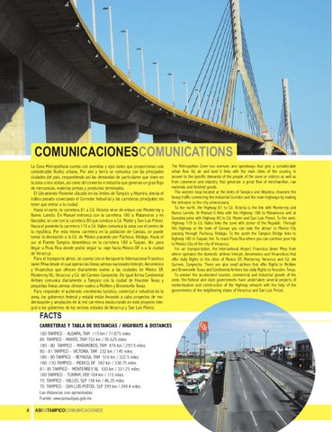
COMUNICACIONESCOMUNICATIONS La Zona Metropolitana cuenta con avenidas y ejes viales que proporcionan una considerable fluidez urbana. Por aire y tierra se comunica con las principales ciudades del país, respondiendo así las demandas de particulares que viven en la zona o nos visitan, así como del comercio e industria que generan un gran flujo de mercancías, materias primas y productos terminados. El Libramiento Poniente ubicado en los límites de Tampico y Altamira, desvía el tráfico pesado conectando el Corredor Industrial y las carreteras principales sin tener que entrar a la ciudad. Hacia el norte, la carretera 81 a Cd. Victoria sirve de enlace con Monterrey y Nuevo Laredo. En Manuel entronca con la carretera 180 a Matamoros y en González se une con la carretera 80 que conduce a Cd. Mante y San Luis Potosí. Hacia el poniente la carretera 110 a Cd. Valles comunica la zona con el centro de la república. Por esta misma carretera en la población de Canoas, se puede tomar la desviación a la Cd. de México pasando por Pachuca, Hidalgo. Hacia el sur el Puente Tampico desemboca en la carretera 180 a Tuxpan, Ver. para llegar a Poza Rica donde podrá seguir su viaje hacia México DF o a la ciudad de Veracruz. Para el transporte aéreo, se cuenta con el Aeropuerto Internacional Francisco Javier Mina desde el cual operan las líneas aéreas nacionales Interjet, Aeroméxico y Vivaerobus que ofrecen diariamente vuelos a las ciudades de México DF, Monterrey NL, Veracruz y Cd. del Carmen Campeche. De igual forma Continental Airlines comunica diariamente a Tampico con la ciudad de Houston Texas y pequeñas líneas aéreas ofrecen vuelos a McAllen y Brownsville Texas. Para responder el acelerado crecimiento turístico, comercial e industrial de la zona, los gobiernos federal y estatal están llevando a cabo proyectos de modernización y ampliación de la red carretera involucrando en este proyecto integral a los gobiernos de los vecinos estados de Veracruz y San Luis Potosí.
The Metropolitan Zone has avenues and speedways that give a considerable urban flow. By air and land it links with the main cities of the country, in answer to the specific demands of the people of the zone or visitors as well as from commerce and industry that generate a great flow of merchandise, raw materials and finished goods. The western loop located at the limits of Tampico and Altamira, channels the heavy traffic connecting the Industrial Corridor and the main highways by making the entrance to the city unnecessary. To the north, the Highway 81 to Cd. Victoria is the link with Monterrey and Nuevo Laredo. At Manuel it links with the Highway 180 to Matamoros and at González joins with Highway 80 to Cd. Mante and San Luis Potosí. To the west, Highway 119 to Cd. Valles links the zone with center of the Republic. Through this highway at the town of Canoas you can take the detour to Mexico City passing through Pachuca, Hidalgo. To the south the Tampico Bridge links to highway 180 to Tuxpan, Ver. To reach Poza Rica where you can continue your trip to Mexico City of the city of Veracruz. For air transportation, the International Airport Francisco Javier Mina from where operates the domestic airlines Interjet, Aeromexico and Vivaerobus that offer daily flights to the cities of Mexico DF, Monterrey, Veracruz and Cd. del Carmen, Campeche. There are also small airlines that offer flights to McAllen and Brownsville Texas and Continental Airlines has daily flights to Houston, Texas. To answer the accelerated tourism, commercial and industrial growth of the zone, the federal and state governments have undertaken several projects of modernization and construction of the highway network with the help of the governments of the neighboring states of Veracruz and San Luis Potosí.
FACTS
CARRETERAS Y TABLA DE DISTANCIAS / HIGHWAYS & DISTANCES 180 TAMPICO – ALDAMA, TAM 115 km / 71.875 miles 80 TAMPICO – MANTE, TAM 153 km / 95.625 miles 180 - 80 TAMPICO – MATAMOROS, TAM 476 km / 297.5 miles 80 - 81 TAMPICO – VICTORIA, TAM 232 km / 145 miles 180 - 80 TAMPICO – REYNOSA, TAM 516 km / 322.5 miles 180 -130 TAMPICO – MEXICO, DF 542 km / 338.75 miles 81- 85 TAMPICO – MONTERREY, NL 530 km / 331.25 miles 180 TAMPICO – TUXPAM, VER 184 km / 115 miles 70 TAMPICO – VALLES, SLP 138 km / 86.25 miles 70 TAMPICO – SAN LUIS POTOSI, SLP 399 km / 249.4 miles Las distancias son aproximadas Fuente: www.tamaulipas.gob.mx 4
ASIESTAMPICOCOMUNICACIONES
FOTO: JORGE R. ETIENNE