1 - RUTLAND Pride FEB 127_Layout 2 20/01/2013 13:36 Page 72
Transport
Is Rutland Going
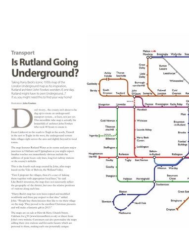
Underground? Taking Harry Beck’s iconic 1930s map of the London underground map as his inspiration, Rutland architect John Fowkes wonders if, one day, Rutland might have its own underground...? If so, you might need this to find your way home! Illustration: John Fowkes
D
on’t worry... the county isn’t about to be dug up to create an underground transport system... at least, not just yet. This incredible tube map is actually the brainchild of architect John Fowkes who took 40 hours to create it.
From Caldecott in the south to Teigh in the north, Tinwell in the east to Tugby in the west, the underground system links villages right across the area and slightly beyond to local towns. The map features Rutland Water as its centre and puts major junctions in Oakham and Uppingham as you might expect. Smaller touches not immediately obvious include the addition of peak hours only lines, long lost railway stations or the county’s airfields. This is the fourth such map created by John, after maps based on the Vale of Belvoir, the Welland Valley. “First I pinpoint the villages, then it’s a case of linking them together with appropriate local lines,” he said. Like Beck’s invention, the map does not necessarily reflect the geography of the district, but uses the relative positions of stations along each line. “Harry Beck’s map has now been copied and modified worldwide and these pay respect to that idea.” added John. “People buy them because they like to see their village on the map. They proved to be excellent Christmas presents. and will make a fantastic gift in 2013.” The maps are on sale at Hirst & Hirst, Church Street, Oakham for £30 (www.hirstandhirst.co.uk) or direct from John’s own website. Customers can also personalise the maps adding their own stations and favourite haunts which are personal to them, making each one potentially unique.