CIVIL WORKS R&D Value


to the Nation 2023 Edition


I’M A FIRM BELIEVER
THAT R&D, WITH THE RIGHT FOCUS, IN THE RIGHT ENVIRONMENT, CAN REALLY HELP US GET AFTER SOME OF THESE STICKY


CHALLENGES
THAT WE ARE EXPERIENCING, WHETHER IT’S CLIMATE CHANGE, WHETHER IT’S ENERGY RESILIENCE, WHETHER IT’S ENVIRONMENTAL SUSTAINABILITY.
LT. GEN. SCOTT SPELLMON
55TH
CHIEF OF ENGINEERS
USACE COMMANDING GENERAL
“ “
FOREWORD
At no time in our nation’s history have the demands on our critical infrastructure been more extensive, nor has the need to invest in that infrastructure been more necessary.
USACE Civil Works projects have contributed significantly to the nation’s well-being, supporting the economy and protecting and improving the lives of Americans with water management innovations to address flood and storm risk, protect the environment and even reduce impacts of drought.
With tremendous support from the administration and Congress, USACE is at the forefront of ensuring that investment preserves our critical infrastructure for decades to come.
As we address today’s challenges, such as refurbishing infrastructure components that are operating well beyond their expected lifespans, we must also position our work to meet tomorrow’s challenges with greater quality and faster solutions. We can achieve these goals through research and development in conjunction with agency, academic and industry partners.
Through world-class research and development, some of which is laid out in the following pages, USACE collaborates with others to solve difficult problems that span engineering disciplines across the nation and internationally.

4
From discovering new techniques to build more resilient infrastructure, to solving water resources challenges facing communities, to nurturing sustainable environments and ecosystems, USACE is delivering on its mission to “serve the public.”
Our mission space, much like our workforce, has never been more diverse than it is today. We are stronger now because of the experience and passion our team brings to this effort each and every day.
The USACE Civil Works program has been provided record levels of funding recently, and with that funding comes increased expectations for the performance and delivery of the program to meet the nation’s water resources needs. While the challenges before us are more complex than ever, I remain confident of our success because our people are more talented than ever.
As always, we stand ready to build better than ever before.
Essayons! Building Strong! Army Strong!
 WILLIAM (BUTCH) H. GRAHAM JR. Major General, USA Deputy Commanding General for Civil and Emergency Operations
5

6
VALUE TO THE NATION Table of Contents USACE R&D Strategy and Civil Works Strategic Focus Areas .......... 8 Value to the Nation Highlights ................................... 12 Climate Mitigation ...................................... 14 Technology Advancements for Improved Coastal NNBF Design ... 16 Using EWN® to Sequester Carbon and Build Coastal Resilience ... 18 NNBF Streambank Erosion Manual ......................... 20 Greener Alternatives for Corrosion Mitigation of Civil Structures .. 22 Water Resilience........................................ 24 Remote Sensing Tools for Water Quality and HAB Monitoring .... 26 Post-Wildfire Support to Native Communities ................. 28 EWN® Approach for Enabling Drought Resilience .............. 30 Reservoir Flushing ....................................... 32 CHRPS: Forecasting Hurricane Ian in Florida ................. 34
CIVIL WORKS R&D:


7 Infrastructure R&D Resilience ........................... 36 Resilience Evaluation via the USACE Navigation Portal ......... 38 Water Resource Infrastructure Digital Twins .................. 40 SHM Partnerships ....................................... 42 Predicting the Remaining Life of HSS ....................... 44 Broadening Benefits ..................................... 46 Building a Business Case for NNBF ......................... 48 Improving USACE Ecological Modeling Practices ............. 50 Vessel Wake Impact Analysis .............................. 52 Quantifying Change and Benefits Using MERIT ............... 54 Communicating Biodiversity in Infrastructure Decisions ......... 56 Environmental Justice ................................... 58 Building Tribal Partnerships to Sustain Cultures and Natural Resources .................................. 60 Archaeological Predictive Modeling Tool ..................... 62 Quantifying “Other Social Effects” for Flood Risk Management ... 64 Credits ..................................................... 66
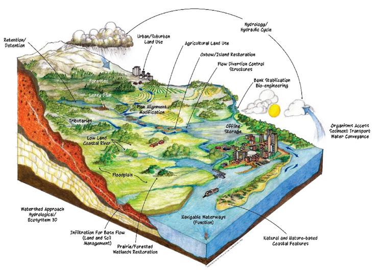
USACE R&D STRATEGY AND CIVIL WORKS STRATEGIC FOCUS AREAS
Lt. Gen. Scott Spellmon, the 55th Chief of Engineers and Commanding General of the U.S. Army Corps of Engineers (USACE), recently issued a challenge to elevate and open a bold new era for USACE R&D.
“It’s my firm belief that we will not build our way out of many of the challenges we face –we have to think, innovate and engineer our way out,” he said. “To do that, we’ll need new, improved, and in some cases yet-to-be-discovered tools and technologies that only a robust and responsive R&D program can deliver.”
Responding to that challenge, leaders across the organization developed the USACE Research and Development Strategy and identified the Top 10 USACE R&D Priorities to address the nation’s toughest challenges through multi-disciplinary, collaborative and proactive approaches.
Further, USACE endorsed six Civil Works Strategic Focus Areas (SFAs) to address these unique challenges. SFAs represent capabilities required for USACE to achieve success in the identified top priorities by innovating and developing solutions to problems impacting Civil Works mission delivery now and into the future. These SFAs, aligned with the R&D priorities, generate near- and long-term benefits for serving our communities, supporting and growing our economy, creating jobs, and enhancing broader societal impacts such as improved public health, national security, resiliency, recreation and tourism.

8
TOP 10 USACE R&D PRIORITIES

MITIGATE AND ADAPT TO CLIMATE CHANGE
WIN FUTURE WARS

MODERNIZE OUR NATION’S INFRASTRUCTURE

SUPPORT RESILIENT COMMUNITIES

ENABLE SMART AND RESILIENT INSTALLATIONS


ENSURE ENVIRONMENTAL SUSTAINABILITY AND RESILIENCE
SECURE RELIABLE INSTALLATION ENERGY
REVOLUTIONIZE AND ACCELERATE DECISION MAKING

IMPROVE CYBER AND PHYSICAL SECURITY

PROTECT AND DEFEND THE ARCTIC

9
USACE CIVIL WORKS STRATEGIC FOCUS AREAS:

1) NEXTGEN WATER RESOURCES INFRASTRUCTURE: Years of deferred construction and maintenance have created backlogs approaching $200 billion. Maintaining and replacing aging infrastructure requires transformative technologies that enable more cost-effective, resilient and reliable solutions within a changing climate, including ultradurable and rapid construction materials and processes, models that predict performance and optimize maintenance, and autonomous inspection techniques.
2) SUSTAINABLE SPECIES MANAGEMENT: USACE spends approximately $400 million each year to manage invasive and nuisance species, such as Harmful Algal Blooms and Invasive Carp, and foster endangered species, such as the Interior Least Tern and Pallid Sturgeon. Advanced technologies and strategies are needed to prevent, detect and manage a diverse range of species for environmental sustainability. Applying technologies such as sensors, unmanned aerial systems, data analytics and modeling tools, while also prioritizing interagency collaboration, can enable improved stewardship of local ecosystems.
3)
INNOVATION
IN


SEDIMENT
MANAGEMENT: Leap-ahead construction and operation technologies are needed to reduce USACE dredging costs that currently exceed $1 billion annually, and enhance environmental sustainability through strategic placement of dredged sediments. Next-generation sensors, advanced modeling and increased publicprivate partnerships carry the potential to spark greater efficiencies. Meanwhile, dredged sediment must be strategically placed using Engineering With Nature® principles to deliver environmental and social benefits toward environmental sustainability, such as healthier wetlands, flood risk reduction, and more sustainable river and coastal shorelines and habitats. Partnering is essential to achieve these goals.
10
4) COMPREHENSIVE WATER RISK MANAGEMENT: The cost of U.S. inland and coastal flood damage has increased 10-fold over the past 40 years, from $5 billion to $50 billion annually. To most effectively manage this growing risk within a changing climate, USACE needs a common operating framework that evaluates comprehensive flood hazards on a continental scale. This framework will incorporate next-generation remote and spacebased observations; advanced numerical modeling methods that analyze the interaction of atmospheric, inland and coastal processes; and the ability to integrate simulation and observation data using machine learning and artificial intelligence. This framework can evaluate lifecycle performance of water resource systems, including nature-based features and traditional infrastructure solutions, and improve arid region forecasting and post-crisis impacts.
5) CRISIS MITIGATION RESPONSE AND RECOVERY: As natural and manmade hazards continue to grow, planners need proactive tools to evaluate how infrastructure will perform during extreme conditions, to understand compound threats, and to identify vulnerabilities and potential cascading failures. Meanwhile, first responders and emergency managers need artificial intelligence capabilities to rapidly collect and analyze data from multiple sources to support decisions. Frameworks must allow for greater integration of data and broad communication across agencies and partners with advanced mobile reconnaissance solutions and supply chain logistics.
6) INNOVATIVE APPLICATIONS OF BIG DATA ANALYTICS, ARTIFICIAL INTELLIGENCE,


AND
AUTONOMY:
Solving the most complex Civil Works problems requires leap-ahead capabilities, such as machine learning and artificial intelligence, to enable rapid risk-informed decision making. This area will combine sensor data with big data analytics, integrate disparate models, and enable trade-space analytics to optimize designs and operations. The result will be a dashboard to evaluate impacts of alternatives, and a “systems-of-systems” approach to evaluate benefits across USACE’s complex water resource missions.
11

12
VALUE TO THE NATION HIGHLIGHTS

13
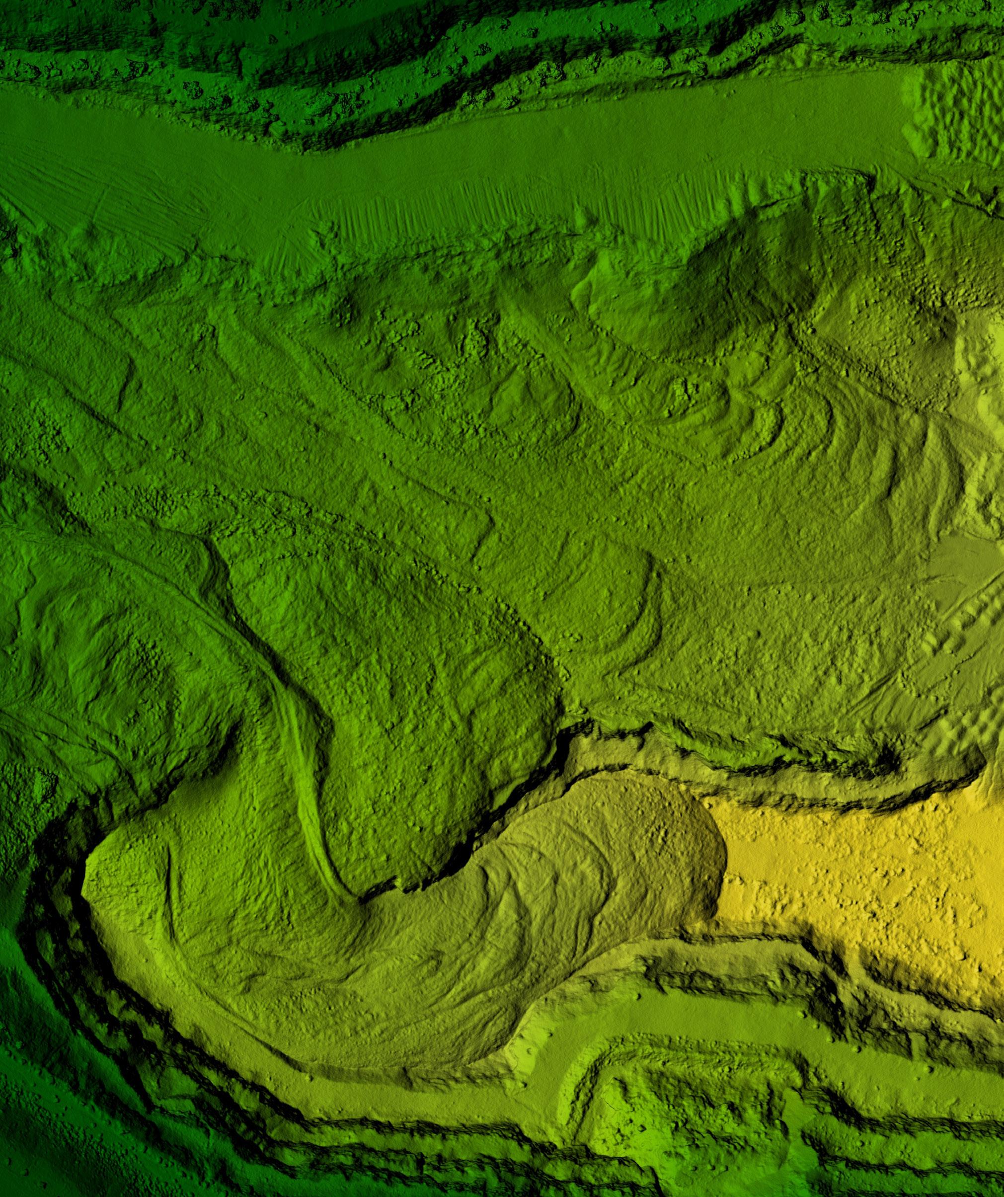
CLIMATE MITIGATION

The mitigation of climate change through improved sustainability in construction materials, carbon sequestration and extended lifecycles of infrastructure projects, reduce emissions through Natural and Nature-Based Features (NNBF).

14


15
TECHNOLOGY ADVANCEMENTS FOR IMPROVED COASTAL NNBF DESIGN


USACE has set a sediment management sustainability goal to beneficially place 70% of dredged sediment to support navigation, flood risk management and environmental missions. Despite this goal, only a small fraction of dredged sediment is placed in the coastal nearshore or beach zone.


To reach this goal, USACE practitioners need a suite of rapidly deployable coastal models that can evaluate beach nourishment design alternatives that beneficially use dredged sediment, including subaerial beach and dune nourishment and nearshore placement, to be accessible during the project scoping and planning phases.
The historical models used to evaluate coastal beneficial use projects required significant improvements to capture sediment transport in the nearshore, swash zone and aeolian (windblown) transport on the subaerial beach. Physics-based model advances improve the reliability of predicted responses from Natural and Nature-Based Features (NNBF) to nourishment strategies.


16 MITIGATE AND ADAPT TO CLIMATE CHANGE
Reliable and easy-to-use sediment transport models are needed to evaluate beach nourishment alternatives that beneficially use dredged sediment from navigation channels. These alternatives can support the USACE flood risk management mission by augmenting the nourishment schedule for Coastal Storm Risk Management projects with either subaerial placement of sand on the beaches and dunes, or by placing the sediment in the nearshore. The lack of reliable predictive capabilities for nearshore hydrodynamics and morphology change, including aeolian sediment transport, have prevented design optimization.
STREAMLINES
PROBLEM SOLUTION IMPACT
Civil Works R&D is supporting development of tools with better formulations and incorporating them into the existing Coastal Modeling System to significantly improve predictions for nearshore processes, including waves, currents, swash and aeolian transport. USACE practitioners can readily apply the system to predict the coastal dune and beach placement response to nourishment alternatives. With a reliable coastal model, planners and engineers can quantify NNBF benefits for increased coastal community resilience and optimize beneficial use alternatives.
Evaluating beneficial use alternatives can be done more accurately and efficiently through improved model formulation in the existing Coastal Modeling System that USACE practitioners routinely use to study flooding, wave impacts, sediment transport and coastal morphology.

17
THE EVALUATION OF COASTAL BENEFICIAL USE OF DREDGED SEDIMENT ALTERNATIVES
Since the early 1600s, the historical extent of wetlands in the U.S. has decreased by 50%, increasing flood risk and storm damage. Concurrently, atmospheric carbon dioxide concentrations have increased more than 30% over the past 150 years, warming the planet and increasing storm intensity. These changes limit the capacity to mitigate climate change.

PROBLEM SOLUTION
EWN projects that create or enhance coastal zone habitats provide opportunities to increase resiliency through reduced flood risk, sequester additional carbon from the atmosphere, and help to offset future carbon emissions. Civil Works researchers are collaborating with the University of Central Florida to understand carbon storage dynamics to promote practices that maximize carbon and resiliency benefits using EWN.
IMPACT
Initial results suggest that EWN projects constructed using dredged materials may result in long-term carbon sequestration through mineral complexation, ensuring projects yield flood risk reduction benefits to communities, provide for ongoing navigation channel maintenance, and deliver sustainable and resilient resources for decades to come.
FLOOD RISK REDUCTION BENEFITS AND CARBON SEQUESTRATION STRATEGIES TO MITIGATE AND ADAPT TO CLIMATE CHANGE
18
USING EWN® TO SEQUESTER CARBON AND BUILD COASTAL RESILIENCE


Coastal ecosystems are resilient landforms that reduce storm surge and store large amounts of carbon. Carbon stored in coastal and marine systems is called blue carbon, and it regulates global temperatures through greenhouse gas absorption and sequestration.
Wetlands, mangroves and seagrasses store carbon 10 times faster than mature tropical forests such as the Amazon. Their high carbon storage potential and natural resiliency highlight their capacity to mitigate and adapt to climate change. As such, coastal ecosystem restoration and enhancement is a negative emissions strategy to offset fossil fuel combustion while abating storm and flood impacts to communities and infrastructure.
Engineering With Nature® (EWN) projects that restore or create coastal wetlands using dredged sediments can reduce storm surge while accumulating blue carbon over time, providing opportunities for long-term flood risk reduction and increased carbon storage. Ongoing research is investigating the potential for EWN projects to protect carbon stocks through mineral complexation and associated linkages with flood risk reduction. The EWN paradigm provides unique opportunities to increase ecosystem resiliency, manage the coastline to maximize societal benefits, and continue to promote innovative dredged sediment management strategies that support navigation, environmental and flood risk management missions.

MITIGATE AND ADAPT TO CLIMATE CHANGE 19
Unstable river channels severely impact flood risk management structures, bridges and roadways, navigation channels, reservoirs and fluvial ecosystems. River channel erosion results in an estimated 40-60% of sediment delivered to downstream waterways. Appropriate tools to assess and analyze these impacts are needed for watershed and geomorphic investigations. Additional tools are needed to provide NNBF design guidance for fluvial systems restoration and stabilization.
An NNBF Streambank Manual will provide the tools to conduct geomorphic assessments on a watershed scale. NNBF design guidance will address the potential for sediment stabilization in the streambank by identifying sediment sources, pathways, sinks, channel stabilization and enhanced ecological function designs for watershed recovery.
PROBLEM SOLUTION IMPACT
The new NNBF Streambank Manual will update existing guidance that is more than 30 years old with improved knowledge and tools for USACE and partner agencies. Benefits include rapid design protocols, cost-effective solutions and improved environmental enhancements. Initial evaluations suggest cost savings upwards of 50-60% and result in greater ecological function and benefit.
The NNBF guidance will reduce sedimentation, stabilize channels and streambanks, enhance flood risk management projects and increase habitat enhancement benefits for restoration projects.

20
RIVERBANK EROSION RESULTS IN 40-60% OF THE SEDIMENT TO DOWNSTREAM REACHES AND RESERVOIRS
NNBF STREAMBANK EROSION MANUAL

Properly functioning river ecosystems with riparian corridors provide nutrient cycling, water quality benefits, aquatic and terrestrial habitat benefits, and reduced sediment delivery to downstream reaches.


Natural and Nature-Based Features (NNBF) are nature’s way of providing these functions, but many natural systems have degraded over time. USACE requires guidance for NNBF implementation to achieve desired outcomes. Specific needs are to efficiently design and construct new sustainable and resilient NNBF systems that achieve the desired outcome and meet local project sponsor needs. Researchers are documenting emerging outcomes from NNBF research and development to provide the most up-to-date design guidance as a part of the NNBF Streambank Manual.

MITIGATE AND ADAPT TO CLIMATE CHANGE 21
GREENER ALTERNATIVES FOR CORROSION MITIGATION OF CIVIL STRUCTURES


Bridges, locks, dams and other civil infrastructure are critical to ensuring safe, timely transportation of citizens and domestic goods regardless of climatic conditions. They must withstand detrimental conditions, turbulent waters, salt de-icing and high UV exposures. Coatings serve as the first line of defense to provide sustainability and resilience of our nation’s infrastructure.

Specified coatings in use today were formulated decades prior to understanding how construction practices can impact the environment. So, while they can provide the protection necessary in extreme environments, they incur an environmental impact.
USACE urgently needs greener coatings that can ensure the sustainability and resilience of Civil Works structures and the ability to streamline formulation and assessment of developed technology. USACE has developed novel surface preparation techniques and researched novel siloxane-based coatings that provide steps to greener corrosion mitigation.

22 MITIGATE AND ADAPT TO CLIMATE CHANGE
RESILIENT STRUCTURES AT
A LOWER ENVIRONMENTAL COST
Corrosion is the natural degradation of any material, not just metals, due to the environment in which the material is placed. Mitigating corrosion constitutes 3.1% of the Gross Domestic Product, directly costing the nation approximately $276 billion annually. While some conventional coatings can provide proper levels of protection, their environmental impact is detrimental, requiring undesirable components such as ozone-depleting solvents.
PROBLEM SOLUTION
Civil Works R&D is supporting development of novel surface preparation techniques that can simultaneously embed corrosion inhibitors into surfaces during normal surface preparation activities. In combination with research into low volatile organic content siloxane-based coatings, large advancements have been made towards greener alternatives to corrosion mitigation while also driving down implementation costs.
IMPACT
Siloxane-based coatings provide optimal corrosion protection at lower costs in atmospheric environments in dozens of locations and environments, sustaining both barrier and aesthetic properties. Successful demonstration of the novel surface preparation and coating combination was completed at Rock Island Arsenal, Illinois, in 2021, restoring an operating historical trestle bridge.

23
WATER RESILIENCE

Climate change is producing increased uncertainty, frequency, intensity and duration of droughts and floods (weather whiplash), along with overall changes to sea level and average annual temperature and rainfall patterns. Proposed R&D efforts will create better understanding and quantification of these extreme events to better inform design and management decisions.
24

25
REMOTE SENSING TOOLS FOR WATER QUALITY AND HAB MONITORING


With changing climate conditions and extreme weather events, the U.S. is experiencing an increase in the occurrence, intensity and extent of Harmful Algal Blooms (HABs), which pose a significant threat to the nation’s water resources and economy, impacting reservoir operations, recreation, water supply, wildlife and public health and safety.


USACE Districts have the challenge of operating, maintaining and monitoring hundreds of inland waterbodies and water resource development projects that cover vast geographic areas, often while managing simultaneous HAB outbreaks with limited water quality staff. Remote sensing tools can significantly improve early detection and management of HABs, while allowing Districts to focus limited resources where they are most needed.
Civil Works R&D supported development of a series of decision support tools with varying capabilities to meet a wide range of early detection and monitoring needs and end-user skill sets across more than 20 Districts that are actively engaged in HAB response. The satellite image-based software tools can be used to quickly produce image-based abundance maps of HAB water quality indicators. The tools make use of simple algorithms, allowing for more comprehensive water quality monitoring and leading to more proactive HAB detection and management.
26 REVOLUTIONIZE AND ACCELERATE DECISION
MAKING
REVOLUTIONIZE HAB MONITORING FOR PROACTIVE HAB RESPONSE AND MANAGEMENT
Over the last decade, the U.S. has spent more than $1 billion on HAB treatment and prevention, with approximately $50 million spent annually to address known HAB-related impacts. Given the extensive and expanding nature of the problem and the limitations of traditional field-based monitoring, responses to HAB events are often reactionary or delayed.

Civil Works R&D developed satellite imagebased decision support tools to rapidly detect potential HABs by estimating water quality indicators. These tools accommodate a broad range of skills and needs across Districts and range in complexity and functionality. These technologies were transitioned to USACE decision makers through user guides, recorded webinar training and other online technical transfer materials.
PROBLEM SOLUTION IMPACT
The decision support tools can be run in minutes to hours to identify and map potential HAB extents, resulting in a weeksto-months decrease in management decision time from previous field data collection efforts. Not only do these tools result in significant cost and time savings, they also enable a synoptic view of a lake’s surface, which is not possible with spatially limited sampling. Additionally, USACE can use the maps to optimize the location and timing of future toxicity sampling to further cost and resource savings and accelerate response to HABs at USACE water resource development projects.
27
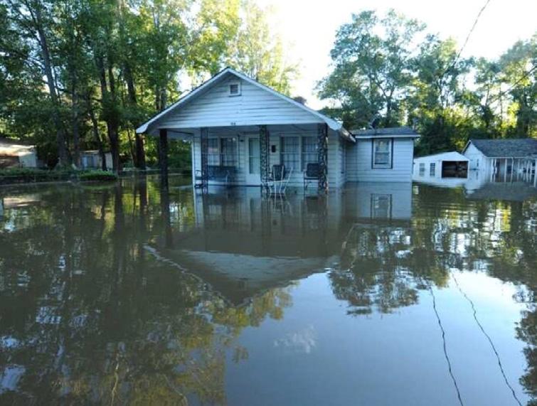
In 2022, more than 65,000 fires burned more than 7.4 million acres in the U.S. alone. Many produced deadly and destructive debris flows along with flooding. Wildfires reduced channel capacity and produced massive debris flows, consequently increasing the potential for floods, erosion and sedimentation. Current methodologies lack the ability to predict these risks accurately and in a timely manner, leaving communities vulnerable to postwildfire flooding.

Civil Works R&D is developing new methodologies, operational responses and numerical modeling techniques with higher accuracy and improved capability to quickly predict the areas at highest risk for deadly debris flows and flooding. These improved approaches will provide local, state and federal planners and emergency responders the information needed to mitigate and manage these increased wildfire and flood risk threats.
PROBLEM SOLUTION IMPACT
On April 6, 2022, the Hermits Peak/Calf Canyon wildfire in New Mexico, near Las Vegas, burned more than 341,000 acres . This wildfire significantly increased flood and debris flow risk to downstream communities. Improved technologies developed through Civil Works R&D were rapidly deployed to quickly provide near real-time emergency management tools for evacuations. This rapid support ultimately saved lives and provided accurate information to protect infrastructure and properties downstream.

28
8:1FOR PRE-HAZARD MITIGATION CAPABILITY INVESTMENT ROI
POST-WILDFIRE SUPPORT TO NATIVE COMMUNITIES


The intensity and frequency of wildfires in the U.S. is increasing with changing climate, bringing immense devastation that may be compounded by typical and extreme precipitation events. Flood risks increase exponentially after a wildfire due to sediment hazards, vegetation loss, soil changes and reduced reservoir capacity. Destructive debris floods can be a thousand times larger than prewildfire floods.

In the past, limited understanding of increased risk left fire-torn communities particularly vulnerable to flooding. USACE needs a fast, reliable method to assess the risks of wildfire impacts on flood risk management, as well as quantitative approaches to predict changes in streamflow and sediment runoff for planning and designing flood control measures.
In 2022, Civil Works R&D funds were invested in incorporating non-Newtonian physics and simple yet effective empirical-based hydrology approaches to account for wildfire effects into existing USACE hydrologic and hydraulic numerical modeling systems. As a result, new modeling techniques were developed that are capable of predicting, with high accuracy, the areas at greatest risk for deadly debris flows.

29 MITIGATE AND ADAPT TO CLIMATE CHANGE
NATURE-BASED SOLUTIONS FOR DROUGHT RESILIENCY
Changing climatic and hydrologic conditions alter USACE’s ability to deliver its flood risk management, water supply, hydropower, navigation, recreation and aquatic ecosystem restoration missions. Intensified climate change and extreme drought significantly affect precipitation, hydrology and availability of water, all further impacts to USACE missions.
Under the EWN approach, nature-based solutions and best practices such as using natural water cycles in biogeochemical processes provide the foundation to establish and sustain water resources development projects that are climate resilient. Through a watershed systems approach, groundwater recharge, strategic reservoir releases and managing wildfire consequences build ecosystem health while ensuring greater drought resilience.
PROBLEM SOLUTION IMPACT
EWN approaches reduce drought vulnerabilities for more sustainable water resource infrastructure, while also increasing water resource development projects’ economic, natural and social values and outcomes.

30
APPROACH FOR ENABLING DROUGHT RESILIENCE


Since 1980, there have been 338 weather and climate-related disasters in the U.S. alone, with total costs approaching $2.3 trillion.
USACE manages multiple water resource development projects, including reservoirs and inland waterways that may be used for flood risk management, water supply, hydropower, navigation and recreation. Climate change affects the frequency, intensity, duration and spatial extent of drought in the U.S., impacting USACE’s ability to deliver sustainable and resilient water resources to the nation.
Employing the Engineering With Nature® (EWN) approach of innovative natural and naturebased solutions for drought resilience, some of the most pressing climate change challenges, such as drought, heat, winds, wildfire, desertification and soil erosion can be overcome by monitoring, preparing for and adapting to these extreme weather events. EWN approaches use natural systems and processes to create resilient solutions for changing hydrologic and climatic conditions with more diverse and positive economic, natural and social values and outcomes.

31
EWN®
MITIGATE AND ADAPT TO CLIMATE CHANGE
RESERVOIR FLUSHING


Dams pool river water to provide flood risk management, hydropower, recreation, water supply and other benefits. However, dams also interrupt the natural flow of sediment being transported through these rivers. This sediment accumulates in the reservoir created by the dam and can cause problems throughout the system. Problems due to sedimentation range from increased flooding upstream, to loss of flood storage in the reservoir, to channel and bank instabilities downstream.
Reservoir flushing is the technique of opening gates on the dam to allow the river’s natural energy and stored water in the reservoir to move sediment downstream. USACE researchers investigated this technique at multiple reservoirs, identifying the benefits and potential impacts. They also made improvements to numerical models to better simulate the effects of reservoir flushes, enabling better-informed decision making, in conjunction with regulatory partners.

32 MITIGATE AND ADAPT TO CLIMATE CHANGE
Our nation’s dams are aging, and the U.S. will continue to rely on this infrastructure for decades – or even centuries –beyond its design life. The extended duration of dam operation increases sediment deposition, reducing project benefits and causing problems throughout the system. The National Reservoir Sedimentation and Sustainability Team’s best estimate is that the U.S. has already lost 17% of constructed reservoir capacity due to sedimentation, but this number could be as high as 30% and may grow to more than 50% by 2050.

ADVANCEMENTS IN RESERVOIR FLUSHING PREDICTIONS
Reservoir drawdown flushes that use the power of the river and stored water to remove sediment are a low-cost option to remove sediment from reservoirs. Civil Works R&D supported research to observe, measure and model several reservoir flushing events with the Hydrologic Engineering Center – River Analysis System (HEC-RAS) numerical model.
PROBLEM SOLUTION IMPACT
These studies provided confidence in our methods, model parameters and lessons learned to reduce the risk of other reservoir flushing events. USACE also added new capabilities to HEC-RAS to simulate reservoir flushes. Multiple Districts are using this information and technology to evaluate and negotiate sustainable sediment management at some of our most impacted reservoirs.
33
INFORM STAKEHOLDERS TO EXTEND THE LIFE OF RESERVOIRS
CHRPS: FORECASTING HURRICANE IAN IN FLORIDA
On September 24, 2022, Tropical Storm Ian formed, and over the next few days, strengthened and headed in the direction of Florida’s west coast. As it strengthened, Ian’s track and intensity varied as it approached the coast. During this time, researchers with the ERDC Coastal and Hydraulics Laboratory assessed storm surge impacts on the western Florida peninsula using the Coastal Hazards Rapid Prediction System (CHRPS). Civil Works R&D developed CHRPS to provide real-time estimates of hurricane hazards. It leverages more than 4,300 synthetic tropical cyclones (TCs) developed as part of the Coastal Hazards System (CHS) and simulated using the Coastal Storm Modeling System’s high-resolution, coupled hydrodynamic wave models in a high-performance computing environment.
Recent advancements in machine learning allow CHRPS to provide efficient coastal storm hazard predictions while maintaining the accuracy of state-of-the-art simulations. Utilizing atmospheric TC parameters from each forecast advisory, CHRPS was executed in a deterministic prediction mode during Hurricane Ian to estimate storm surge at millions of point locations along the landfall region. The information was provided to the USACE South Atlantic Division and Jacksonville District within minutes following each new forecast issuance.


34 REVOLUTIONIZE
DECISION
AND ACCELERATE
MAKING
Obtaining timely coastal hazard information with an approaching tropical cyclone is critical for USACE emergency operations and disaster response. State-of-the-art hydrodynamic models provide accurate estimates of coastal hazards, but these models require thousands of hours of computational time to run for a single deterministic forecast.

CHRPS leveraged previously simulated highresolution hydrodynamic simulation results and machine learning techniques to provide accurate estimates of Hurricane Ian’s storm surge at a very high spatial resolution in a fraction of the time. This efficiency allows CHRPS to rapidly vary the storm’s forecast track and characteristics to provide estimates of the coastal hazards in addition to the deterministic forecast.
PROBLEM SOLUTION IMPACT
CHRPS has been used to aid in estimating storm impacts and supporting disaster response by USACE Districts and Divisions. For Hurricane Ian, CHRPS-estimated inundation agreed with gauge measurements with less than 10% error, which is comparable to more expensive computational estimates. CHRPS results are also obtained up to 10,000 times faster than those estimates, allowing for more efficient storm response development.
35
RAPID ASSESSMENT OF COASTAL HAZARDS FROM IMPENDING HURRICANES

36
INFRASTRUCTURE R&D RESILIENCE
Civil Works R&D is developing new materials and practices, advanced maintenance and construction techniques, new structural designs, innovative data analysis capture, techniques and tools, computer models, and other methodologies to ensure America’s civil infrastructure is resilient, affordable and supports the demands of tomorrow. The outcome of these activities will improve system reliability and mitigate supply chain disruptions, enhance resilience of infrastructure to future climate-induced extreme weather, and radically modernize our aging infrastructure portfolio to support the future needs of the nation.

37
UNIQUE COMBINATION OF DATA ACCESS AND DATA VISUALIZATION CAPABILITIES
Currently, USACE navigation tools and datasets are stove-piped, with inconsistent interfaces and an inability to share data between applications. Incompatible tools and separate map formats have different data access methods and requirements, variable user learning curves, and a lack of adaptability. Decision makers lack ready access to the full operating picture needed for efficient execution of the USACE navigation mission.
The USACE Navigation Portal provides a data science and visualization platform for users to examine navigation data in a single workspace. Information on channel conditions from hydrographic surveys, shoaling predictions based on historical infilling rates, historical and real-time vessel positions and tracks, and other data sets of interest provide a picture of USACE navigation activities.
PROBLEM SOLUTION IMPACT
The USACE Navigation Portal provides transformative, leap-ahead capabilities for field practitioners nationwide, saving millions annually through streamlined decision making and more efficient asset deployment. The quantitative, datadriven analyses provided by the Navigation Portal will allow USACE to be more deliberate with waterway operations and maintenance.

38
RESILIENCE EVALUATION VIA THE USACE NAVIGATION PORTAL


The USACE navigation mission spans 25,000 miles of waterways and hundreds of coastal structures. These waterways and structures support safe navigation of commercial and recreational vessels ranging from tankers and cargo ships to fishing vessels and recreational pleasure craft. Understanding how and where these vessels move through U.S. waters is critical for planning and executing waterways maintenance.
The USACE Navigation Portal combines data on historical shoaling rates and dredging maintenance cycles to allow managers to proactively plan navigation operations, while also understanding the impacts of delayed maintenance within a single project and across the network of U.S. ports. By incorporating the latest technologies in cloud computing, information system connectivity and data visualization, the Navigation Portal provides fresh insights into the broad portfolio of navigation projects maintained by USACE. The geospatial analysis and visualization capabilities made possible by the Navigation Portal cloud-computing architecture enable quantification of resilience indicators for navigation systems across a wide range of spatial and temporal scales.

REVOLUTIONIZE AND ACCELERATE DECISION MAKING
39
WATER RESOURCE INFRASTRUCTURE DIGITAL TWINS


Our nation’s dam infrastructure is aging, with much of it already operating beyond its life expectancy. These aging structures face wear of components and structure, elevating the threat of a catastrophic failure. Dams with a high risk of failure require urgent undertaking to rehabilitate the structure back to a stable, functional level. Unfortunately, this rehabilitation process is costly and labor-intensive. By understanding the failure modes and associated risks and uncertainties of any dam, it is possible to quantify failure risks and aid dam infrastructure rehabilitation.
This effort built a framework for risk and uncertainty to inform a digital twin – a numerical representation of a physical asset - that allows for real- or near real-time risk and uncertainty analysis across a dam’s infrastructure. The digital twin framework leverages moments of failure and inference to utilize both physics-based failure modes and data to determine current and predictive risk probabilities and uncertainties. Using physics-based failure mode models, a digital twin represents a dam’s current and predicted states, providing the user initial estimates of risk and uncertainty with Artificial Intelligence and Machine Learning computational models that will inform future data-informed digital twins of gravity and embankment dams.
40
DIGITAL TWINS PROVIDE DECISION SUPPORT TO REDUCE FAILURE RISK OF CRITICAL INFRASTRUCTURE

Addressing the wear of components and structure in aging dam infrastructure is costly and labor-intensive. With the increasing need for rehabilitation, decision makers need information to better prioritize projects and identify critical structural issues before the structure fails.
Civil Works R&D is supporting development of a modular framework for digital twin development that allows for real- or near real-time structural health monitoring to better inform decision making. This framework currently includes risk and uncertainty modeling, near real-time sensor data, computational modeling, 3-dimensional modeling and geological models.
PROBLEM SOLUTION IMPACT
To date, version 1.0 of the digital twin framework has been created and will be deployed for Isabella

Dam in California and Bluestone Dam in West Virginia digital twins in 2023. Development plans for 2023 include expanding the framework to address further monitoring needs.

MODERNIZE OUR NATION’S INFRASTRUCTURE 41
SHM PARTNERSHIPS

Structural Health Monitoring (SHM) is the science of making accurate condition assessments about the ability of structures to perform intended design functions based on sensor data, multi-physics models and advanced statistical analysis. The SHM program’s vision is to provide continuous, actionable information to owners and operators to ensure the continued operability of USACE critical infrastructure.


The SHM program executes research through USACE partnerships with several academic and industry collaborators. Outcomes from the first five years of collaboration included advancements in digital twin core modeling, robotic and unmanned inspections, non-contact and remote sensing for digital twins, and novel sensing and data acquisition techniques.

42
MODERNIZE OUR NATION’S
INFRASTRUCTURE
USACE operates an infrastructure portfolio with a replacement value of more than $250 billion that annually facilitates the transportation of more than $2 trillion in goods. More than 50% of the portfolio was built 50 or more years ago and must be operated and maintained under tightening budgets. To preserve the useful function of this infrastructure, it is critical to provide accurate and actionable information on the condition and performance for smart investment decisions.
With guidance and oversight from the ERDC Structural Health Monitoring program, this USACE, academic and industry partnership focused on addressing some of the toughest SHM challenges. The results include technological advancements for new foundational, assessment, remote sensing/inspecting, monitoring and predictive capabilities to inform digital twin models of USACE infrastructure.

PROBLEM SOLUTION IMPACT
The five-year SHM collaborations resulted in more than 30 peer-reviewed journal publications, with more in review. These publications span a wide variety of directed research and involve the work of professors, students and multiple ERDC professionals. The advancements funded by the SHM program will provide the foundation for the next five years of SHM research and will be implemented where applicable within the USACE infrastructure portfolio.
GROUNDBREAKING
43
5-YEAR PARTNERSHIP IN SHM RESEARCH RESULTED IN FOUNDATIONAL TECHNOLOGIES TO INFORM BETTER INFRASTRUCTURE DECISIONS
Presently, methods and tools are not widely available to predict crack formation nor the implications of those cracks on the structure’s performance. Without these tools, engineers are left with little more than intuition to guide decisions about repair and rehabilitation. This results in uncertainty and potentially overly conservative or deferred decisions, creating significant costs for USACE and the U.S. economy.

PROBLEM SOLUTION
This project will develop a methodology to perform lifecycle analysis for HSS considering metals fatigue. The methodology will manifest in three phases: predicting locations of crack initiations; modeling crack growth rate and directions; and predicting structural failure due to cracking.
IMPACT
ERDC has created a research tool to predict crack initiation in HSS. This tool provides locations and likelihood of fatigue cracks. With crack location information, the tool can target inspections to critical regions. With crack likelihood information, this tool can aid decision making and overall lifecycle management.
PER PROJECT $10K SAVINGS OF MORE THAN
44
PREDICTING THE REMAINING LIFE OF HSS
Structural Health Monitoring (SHM) allows for accurate condition assessments on the current and future ability of a structure or system to perform its intended functions using inspection/sensor data, multi-physics models and statistics. In this way, observable condition data can be transformed into actionable decision support information for Operations and Engineering leadership.


One significant failure mechanism for hydraulic steel structures (HSS) is the formation and propagation of fatigue cracks. Cracks that form may be stable and self-limiting or unstable and pose a significant risk to structural performance. This project’s purpose is to develop a methodology to perform lifecycle analysis for HSS considering metals fatigue. Civil Works R&D is developing tools to predict locations of crack initiations given historic and expected future loadings; define crack initiation as failure; and provide an assessment of structural reliability given predicted initiation of cracking.

MODERNIZE OUR NATION’S INFRASTRUCTURE
45


46
BROADENING BENEFITS
Quantifying the broader benefits that USACE projects bring to the nation, R&D is required to develop methods and tools to more completely capture and quantify those benefits. Benefit categories, “Other Social Effects” (e.g., human well-being, such as health impacts from flood hazard exposure) and “Environmental Quality” are often qualitatively considered and not accurately quantified.

47
NNBF provide more diverse benefits than many conventional projects. USACE District norms for evaluating project benefits are challenged to measure and monetarily quantify benefits for NNBF from initial construction, over life cycles, and beyond single authorized project purposes. This failure to identify and evaluate all Civil Works project benefits may understate the value of NNBF and lead to suboptimal investment decisions.
Civil Works R&D supports research to identify barriers to include NNBF in project designs and showcase successful NNBF solutions and justifications, develop methods to quantify NNBF benefits, and understand tradeoffs in risks.
PROBLEM SOLUTION IMPACT
Civil Works R&D is developing tools to support the future of NNBF implementation. Policy modernization will require that federal investments are justified by public benefits, including environmental, economic and societal goals, as well as sustainable and resilient infrastructure. NNBF can be part of a transformative approach to reduce systemic risk posed by climate change and increase social and ecological resilience, while broadening the benefits of USACE Civil Works projects.

48
QUANTIFYING NNBF BENEFITS ENABLES A BROADER RANGE OF CIVIL WORKS PROJECT BENEFITS AND MORE RESILIENT WATER RESOURCE DEVELOPMENT PROJECTS
BUILDING A BUSINESS CASE FOR NNBF

Although USACE has more than 100 years’ experience using Natural and Nature-Based Features (NNBF) for a range of Civil Works missions, there is substantial potential to more broadly implement NNBF for greater benefits at a lower cost to U.S. taxpayers. The resilient and dynamic properties of NNBF make them particularly valuable as climate change leads to wider ranges of boundary conditions during project lifespans.


Diverse stakeholders such as Congress, USACE headquarters, non-federal sponsors, state and local governments, and USACE design teams have all called for the increased use of NNBF. Yet the benefits of these features are generally considered ancillary to a project’s primary intended benefit, and therefore they are not considered in project business case development.
By finding innovative ways to quantify NNBF benefits, Civil Works R&D is enabling the next generation of Civil Works projects.
REVOLUTIONIZE AND ACCELERATE DECISION MAKING 49
IMPROVING USACE ECOLOGICAL MODELING PRACTICES


USACE planners needed help to quickly analyze ecological impacts to proposed aquatic ecosystem restoration projects. To meet this need, Civil Works R&D supported development of a process to create rapid ecological models that were sensitive to USACE aquatic ecosystem restoration plans, easily implemented to stay within planning schedules and budget, and were scientifically justifiable. In addition, ERDC built standardized platforms for habitat index-based model execution, allowing consistent and comparable model outputs.
The EcoRest statistical package has more than 100 certified-for-planning habitat suitability index models with associated metadata, providing users unparalleled access to a significant model library and allowing them to create new models based on project needs. This research also developed a rapid group-mediated process to produce sensitive, justified models in as few as three days through facilitated interactive workshops. These workshops and decisionsupport tools enable USACE to quantify the environmental and ecological benefits of its projects, while also increasing confidence in decisions and decreasing budget.
50 REVOLUTIONIZE AND ACCELERATE DECISION MAKING
USACE requires the use of an ecological model to predict environmental benefits under future conditions for all aquatic ecosystem restoration planning studies. Ecological modeling practices must improve to meet SMART planning timelines that require teams to rapidly develop and apply models in short horizons, often 18 to 24 months.
Rapid ecological model development will enable practitioners to meet project needs and save significant time and money per feasibility project. In addition, the EcoRest package allows users to access a multitude of habitat index-based models that can be run quickly or to create new ones using the framework, providing a significant step forward in model access and consistency.
PROBLEM SOLUTION IMPACT
10:1
ROI
FOR EFFICIENT ECOSYSTEM RESTORATION MODELING AND PLANNING STUDIES
The group-mediated model development can successfully produce ecological models within stringent planning timelines and facilitate closer collaboration between USACE and other agencies. This process has been successfully demonstrated in five major planning and operations projects, producing better, cheaper and faster modeling for USACE, while supporting benefit quantification.

51
VESSEL WAKE IMPACT ANALYSIS


The wake produced by commercial vessels along mildly sloping beaches can generate a strong surge that is potentially hazardous to unsuspecting beachgoers. This phenomenon is well known at Tybee Island, Georgia, where reports are commonplace of vacationers caught off guard by overpowering and unexpected vessel-induced surge.
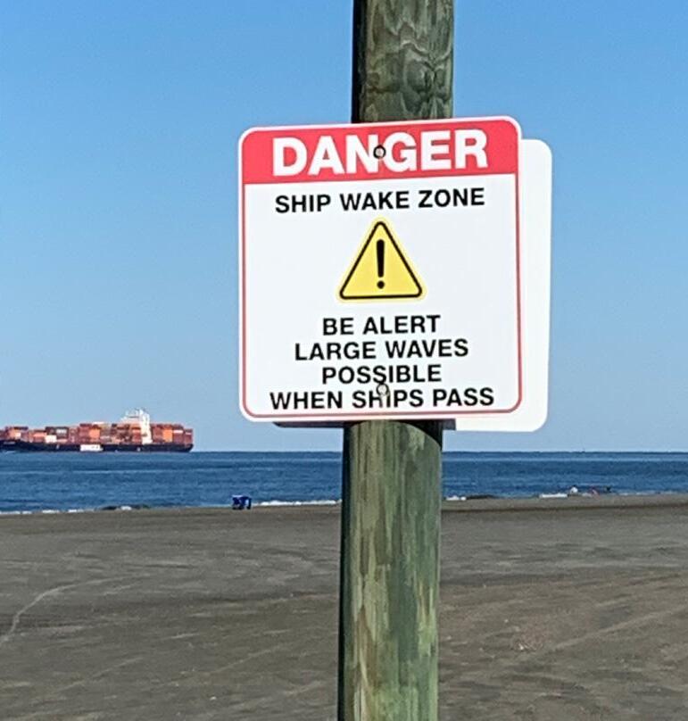
Not all commercial vessels generate large wakes, and the relationship between vessel operations, environmental conditions and wake height is unclear. Uncertainty in cause and effect makes early detection of a potentially hazardous surge extremely difficult.

Civil Works R&D supports high-frequency wave and vessel wake measurements, as well as broadcast vessel identification, to characterize vessel wake conditions. This information helps identify which vessel classes are responsible for dangerous surge and can be used to develop strategies to reduce vessel wake and help protect vulnerable beaches located adjacent to deep draft navigation channels.

52 SUPPORT RESILIENT COMMUNITIES
NOVEL APPROACHES TO REDUCE IMPACTS OF COMMERCIAL VESSEL WAKE ON ADJACENT BEACHES
PROBLEM
Statistical analysis indicates that the largest wakes, and by extension the surge, are correlated with container ships and vehicle carriers traveling at higher speeds, but deficiencies in our present understanding of vessel wake dynamics make it difficult to predict these intermittent surge events. Improved understanding of vessel characteristics, environmental conditions and the resulting impacts is needed, along with a way to diminish the incoming vessel wake and protect beachgoers from the surge.
SOLUTION
Civil Works R&D is coordinating with the USACE Savannah District and local Tybee Island officials to develop a breakwater that would attenuate vessel wake and thus reduce surge risk. The breakwater must be able to reduce the surge but not disrupt sediment transport patterns. A particularly challenging aspect of this project is to ensure the breakwater is designed to manage sediment flow without increasing shoaling in the adjacent navigation channel.
IMPACT
Developing a breakwater that reduces vessel wake yet preserves the ambient environment will open new avenues in breakwater design to help keep people and property safe without disrupting the marine transportation system.

53
QUANTIFYING CHANGE AND BENEFITS USING MERIT
Monitoring ecosystem restoration projects and quantifying their changes over time requires both short-term and long-term land surface monitoring. The combined use of unmanned aerial systems (UAS) and satellite imagery enables effective landscape and natural resource management. However, processing, analyzing and creating derivative imagery products can be time consuming, manually intensive and cost prohibitive.


To provide fast, accurate and standardized UAS and satellite imagery processing and analysis, ERDC developed a suite of user-friendly tools integrated into the graphical user interface (GUI) of ArcMap and ArcGIS Pro, as well as open-source solutions using NodeOpenDroneMap (nodeODM). These tools – the Monitoring Ecological Restoration with Imagery Tools (MERIT) – will enable users to quantify change and benefits over time.

REVOLUTIONIZE AND ACCELERATE DECISION MAKING 54
STANDARDIZED AND EFFICIENT PROCESSING AND ANALYSIS FOR AQUATIC ECOSYSTEM RESTORATION PROJECTS
USACE executes about $500 million in aquatic ecosystem restoration projects nationwide each year. Monitoring, assessing and quantifying ecosystem change and recovery over time can be labor intensive and costly.
MERIT allows users to monitor, assess and quantity the benefits of aquatic ecosystem restoration projects. Integrating remotely sensed data into user-friendly decision-support tools enables USACE to capture broad-scale long-term changes, while saving money and time.

PROBLEM SOLUTION IMPACT
MERIT will save USACE significant time in data acquisition, processing and analysis by allowing users to move from image acquisition and pre-processing to a final output for decision making in one application and more efficient workflows. Although MERIT was designed for monitoring and quantifying aquatic ecosystem restoration projects, many tools have regional or global relevancy for a variety of environmental monitoring initiatives.
55
COMMUNICATING BIODIVERSITY IN INFRASTRUCTURE DECISIONS
Biodiversity loss – the decline in the variety of living organisms – jeopardizes the ecological support systems on which communities depend. To slow this trend, biodiversity conservation and enhancement must be broadly integrated into activities at multiple levels, including major infrastructure programs. While the connection between infrastructure, biodiversity and community outcomes is clear from a scientific standpoint, these narratives have been challenging to communicate in the realms of policy, design and community outreach. Furthermore, biodiversity loss and infrastructure services have historically been distributed inequitably across communities.
This research clarifies the central role of biodiversity in infrastructure planning, design and performance with a specific focus on communicating these connections in broadly accessible formats.


56 SUPPORT
RESILIENT COMMUNITIES
None of the international targets to reduce biodiversity loss were met by the 2020 deadline. Infrastructure planning utilizing the Engineering With Nature® paradigm provides a unique leverage point to enhance biodiversity. Integrated water resource management requires methods for aligning these outcomes and communicating the value of biodiversity to infrastructure designers, decision makers and community members in readily understandable formats.

In partnership with academia, Civil Works R&D is supporting methods to align biodiversity conservation with infrastructure development. These techniques include not only the technical approach but also best practices to communicate these approaches through web platforms, design renderings and novel outlets to maximize accessibility to communities.
PROBLEM SOLUTION IMPACT
Novel communication methods explicitly designed to reach broader audiences and engage communities directly in projects are communicating the value of biodiversity in infrastructure projects to ecological systems and communities.
57
NOVEL COMMUNICATION OF BIODIVERSITY’S ROLE IN COMMUNITIES

58

59
Tribal partners in northern Michigan, Minnesota and Wisconsin report significant declines in wildrice production, which alters the ecological, cultural and socioeconomic services provided by wildrice habitats. Previous management strategies and restoration efforts failed to increase wildrice abundance, exacerbating uncertainties related to the future sustainability of this important grain.

Leveraging tribal knowledge of wildrice ecology and distribution, researchers are working collaboratively with LVD tribal members to understand the environmental causes of declining wildrice production and identify solutions. The multi-year effort includes implementing extensive long-term monitoring and mapping strategies to inform ecosystem management recommendations to tribal partners.
PROBLEM SOLUTION IMPACT
Improving wildrice production protects the cultural integrity, natural resources and ecosystem services that create resilient communities. The combination of indigenous knowledge with scientific research helps tribal partners effectively manage their wildrice populations, increasing sustainability in a changing environment while preserving this important and sacred cultural resource and improving future USACE ecosystem restoration activities in the region.
60
ENSURES SUSTAINABILITY OF A CULTURALLY AND ECOLOGICALLY SIGNIFICANT TRIBAL RESOURCE
BUILDING TRIBAL PARTNERSHIPS TO SUSTAIN CULTURES AND NATURAL RESOURCES
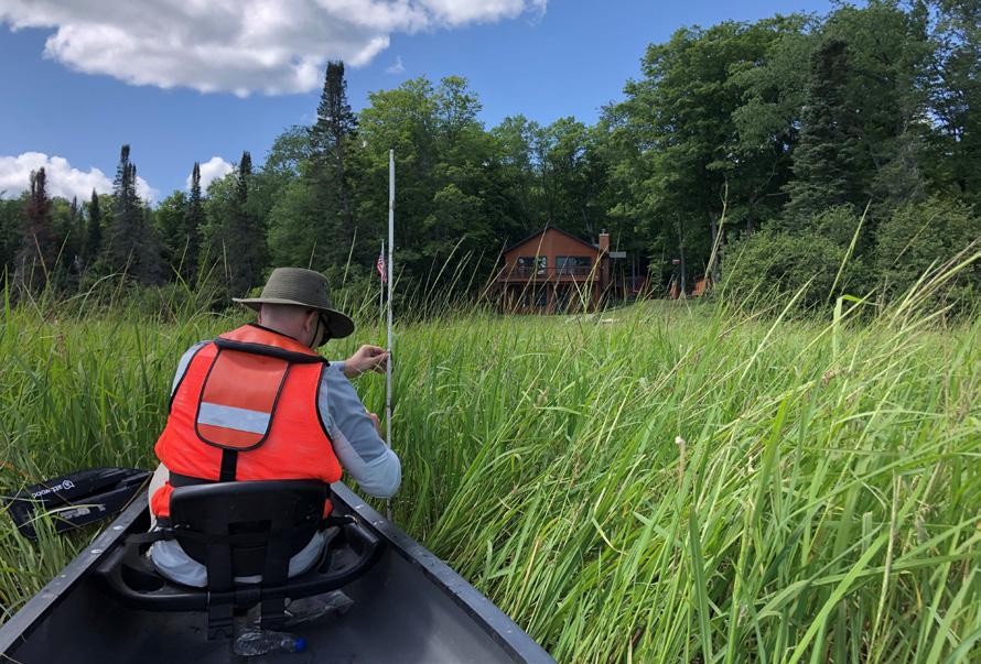


Wildrice, known as “manoomin” in the Ojibwe language, grows in fringe and riparian wetlands in the Great Lakes region, where native communities consider it a sacred food and a vital part of spiritual ceremonies. Wildrice is also important to the economy and ecology of the region, serving as both aquatic habitat for fish and a nutritious food source. In recent years, tribal members reported significant declines in wildrice productivity, despite numerous management and restoration initiatives.
Civil Works R&D is supporting collaborations with the Lac Vieux Desert Band of Lake Superior Chippewa Indians (LVD tribe) to assess the environmental conditions impacting wildrice production through the implementation of a long-term monitoring program. Upon project completion, wildrice monitoring actions and management solutions will transition to local tribal partners, ensuring the future sustainability of this cultural and ecological resource, as well as USACE ecosystem restoration projects in the Great Lakes region.
61 ENSURE ENVIRONMENTAL SUSTAINABILITY AND RESILIENCE
ARCHAEOLOGICAL PREDICTIVE MODELING TOOL


In addition to ensuring the balanced protection of our nation’s aquatic resources and ecosystems, the USACE Regulatory Program protects historic properties, archaeological sites and Tribal resources located in proposed permitted areas. Assessment of these culturally significant assets requires identifying and evaluating effects on resources listed in the National Register of Historic Places, as well as those not listed but eligible for inclusion. However, the lack of tools and capabilities to provide detailed insight on unknown or unlisted cultural resources reduces the protection of those resources and may delay USACE permitting decisions.
Archaeological predictive modeling tools can be used to estimate the likelihood of an archaeological site occurring in a particular location, allowing regulators to modify the intensity and location of cultural resource surveys. Civil Works R&D, in collaboration with USACE and state archaeologists and in coordination with Tribal partners, developed an archaeological predictive modeling tool as a pilot project for the USACE Little Rock District to accelerate USACE Regulatory decision making across the entire District while enhancing the protection of archaeological sites and Tribal resources.
REVOLUTIONIZE AND ACCELERATE DECISION MAKING 62
ENHANCING AND ACCELERATING USACE DECISION MAKING FOR ARCHAEOLOGICAL AND TRIBAL RESOURCES
PROBLEM
Current methods of evaluating sites for archaeological surveys lack the breadth and depth required to identify areas where resource occurrence probability is highest, leading to increased surveys and subsequent review times. The lack of tools to rapidly and effectively evaluate the likely impacts to archaeological and cultural resources may also hamper effective avoidance and minimization of impacts to these resources and delay permitting timelines.
SOLUTION
Civil Works R&D supported development of a GISbased archaeological predictive modeling tool. Using artificial intelligence, the model can be run for an entire USACE District to determine the likely presence of archaeological cultural resources based on environmentally and culturally significant variables. This allows USACE to enhance protection of those resources through targeted cultural resource surveys for more rapid and reliable decision making.

IMPACT
The tool accelerates USACE decision making, minimizes decision risks and increases efficiencies in permit processing by providing more effective and informed cultural resource reviews. The model enhances the protection of archaeological and Tribal cultural resources by more accurately predicting areas of interest and reduces permitting timelines through a rapid, userfriendly USACE Regulatory decision support tool.
63
USACE planners lack tools to assess comprehensive FRM benefits. Without accounting for OSE, current approaches can result in infrastructure over-investment in areas with higher property values. Flood hazard exposure has extensive impact on peoples’ lives and health, but USACE currently has limited ability to assess and integrate those impacts in the planning process.
PUBLIC INVESTMENT DISTRIBUTION
Civil Works R&D can provide an interdisciplinary, comprehensive meta-analysis of flood impacts. This process will identify quantifiable relationships between underlying characteristics, hazard exposure and adverse physical and mental health outcomes. These relationships will then be used to develop planning tools to assess the true impact of flood exposure.

PROBLEM SOLUTION IMPACT
The research and tools being developed will help planners meet the requirements stated in the Assistant Secretary of the Army for Civil Works January 5, 2021 Policy Directive, “Comprehensive Documentation of Benefits in Decision Document.” These advancements will give USACE a truer assessment of infrastructure benefits by adding capabilities for assessing mental health and socioeconomic impacts.
64
TRUER ACCOUNTING OF FLOOD IMPACTS ENABLES MORE EQUITABLE
QUANTIFYING “OTHER SOCIAL EFFECTS” FOR FLOOD RISK MANAGEMENT


This research provides USACE planners and partners with tools to quantitatively assess the “Other Social Effects” (OSE) benefits of flood risk management (FRM) project alternatives. Research results will help USACE decision makers select alternatives that provide the best true value to the nation.

Currently, these OSE benefits are systematically underconsidered in planning, leading to inequitable and suboptimal outcomes. This work will produce defensible quantitative relationships between housing damage and mental health outcomes. These relationships can be leveraged into a model integrated with existing USACE FRM planning models to produce estimated mental health outcomes associated with different flood extents.

REVOLUTIONIZE AND ACCELERATE DECISION MAKING 65
FOR MORE INFORMATION, CONTACT US AT
ERDCINFO@USACE.ARMY.MIL
PUBLISH DATE:
MARCH 2023
APPROVED FOR PUBLIC RELEASE
DISTRIBUTION UNLIMITED
AUTHORED AND EDITED BY:
USACE CIVIL WORKS R&D TEAM
ERDC CORPORATE COMMUNICATIONS OFFICE
DESIGNED BY:
ERDC INFORMATION TECHNOLOGY LABORATORY

66
CONNECT WITH US

67


REPORT NUMBER: ERDC B-23-1
