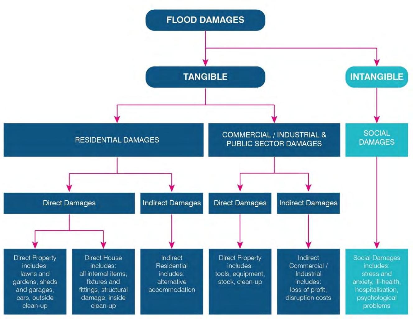
12 minute read
A.2 Anna Bay Secondary Sediment Compartment


A.2.1 Tomaree Headland to Fingal Island
Immediately south of Tomaree Headland, on the open coast side of the Port lies Zenith Beach. The 400 m long beach faces due east, is backed by 10-20 m high foredunes that link with Shoal Bay beach within Port Stephens, the two beaches connect Tomaree Headland to the mainland. Zenith ends at the 140 m high Stephens Peak in the south. South of Zenith are three similar east-facing beaches all within Tomaree National Park. The first (starting from the north) is just a very small 50 m accumulation of sand at the foot of Stephens Peak. Wreck Beach is next, it is a 200 m long and often has an attached sand bar with rips forming against the rocks during higher waves. The southernmost beach is Box Beach, which spans 350 m to the south. Finally, Fly Roads is the open bay and beach that makes up the northern side of Fingal Spit (which connects the mainland to Fingal Island and Point Stephens). This beach runs along the north side of the spit for 1.4 km, facing northeast, and is quite protected by Point Stephens. During severe storm events the beach and spit can be breached resulting in it separating into two and Point Stephens becoming an island (i.e. Fingal Island).
Zenith has a large foredune behind it, and before being highly vegetated, the foredunes behind Zenith would have provided sand to the Shoal Bay tertiary compartment (Short, 2020). Presently, the dunes capture sand from the beach, or exchange sand cross-shore during storm events. Storm waves move sand to the nearshore (and form sand bars), then it slowly works its way back to the beach during calmer conditions. Due to the protection of Fingal Island, and the embayed rocky nature of these pocket beaches, there seems to be no prominent longshore processes. Some sand might be exchanged between beaches during strong northerly wave events, however cross shore processes dominate these beaches. There may be offshore sources of sand slowly making its way back onto these beaches, but this has not been confirmed for this location (Goodwin, 2015). The most southern beach in this sub-compartment is Fly Roads, and it forms the northern side of Fingal Spit, and during severe storm events the beach and spit can be breached resulting in Fingal Island becoming separated from the mainland (Short, 2007)
A.2.2 Fingal Bay
Fingal Bay on the southern side of the split (or tombolo) forms the next embayment, with the Fingal barrier (i.e. the larger sand unit, including the nearshore, beach, dunes and hind dunes sandy areas) slowly receding deep into the bay eroding into Pleistocene Tomaree dune deposits, with relict swamp deposits becoming exposed occasionally after storm periods (Short, 2020; Thom, 1992) Fingal Bay Beach is a southeast-facing 1.5 km semi-circular sandy deposit, that has a 1 km wide rocky entrance between Point Stephens (Fingal Island) and Fingal Head. It can have a double entrance if the northern spit is breached during high wave events. Tomaree National park backs the beach in the north, while settlement and/ or foredunes back the central to southern sections.
A.2.3 Anna Bay (Fingal Head to Morna Point)
There are several kilometres of rocky shore south of Fingal before Anna Bay is reached. Anna Bay is a 2 km wide south-east facing embayment that has the rocky shores of Fingal Head in the north and Morna Point bordering the south. Within this bay are two exposed beaches; Samurai Beach in the north, and One Mile in the south, split by Samurai Point. Samurai Beach curves southwest for 1.1 km, and is backed by active transgressive dunes, which rise to 30 m high (within Tomaree National Park). One Mile Beach extends southward for 1.3 km from Samurai Point, it faces east, and also is backed by transgressive dunes at the northern end. At the southern end of the beach has only a narrow dune which is backed by recreational areas.
This tertiary compartment is backed by active transgressive dunes that extend up to 800 m inland (or 1.5 km of vegetated dunes), which were formed from older dune sands (Tomaree) exposed on the offshore seabed thousands of years ago (Roy, 1996). The combined barrier volume for this embayment (inc. Samurai and One Mile) totals 48 Million m3 (equating to 11,860 m3m-1), and while large amounts of sand have moved into these embayment’s over time, it is unlikely that longshore processes deliver much (if any) supplies of sand, because the bay is surrounded by prominent headlands and rocky shores. It has been suggested that sand bypasses this whole secondary compartment via the high energy shoreface, moving out of Stockton Bight and into either Port Stephens, Yacaaba or beyond (Short, 2020)? Like the other tertiary systems within the Anna Bay compartment though, cross shore processes dominate. Storm waves initiate the nearshore (sand bar)shoreline sand exchange, and aeolian wind energy keeps the active transgressing dunes supplied of sand. Despite these, the system still maintains a positive sediment budget, as it still might be being supplied from the inner shelf. It was found that for the higher energy northern end (Samurai) a modern net sand supply rate of 1.9 m3m-1yr-1 occurs, while the southern end (One Mile) receives about 0.9 m3m-1yr-1 (Goodwin, 2015). This energy grade (supply rate) is also reflected in the prevailing sand bar morphology; a single sand bar dominates One Mile, while the higher energy (and exposed) Samurai has two bars in the nearshore (Short, 2007)
A.3 Newcastle Bight Secondary Sediment Compartment
The Stockton barrier system is one of the biggest in NSW. It is an exposed southeast facing beach-barrier that also has one of the highest energy coastal systems (rip dominated double bar) in the state. The present day transgressive dunes are very active the length of the beach, approximately 40% of the barrier is currently bare and unstable dune sands (Short, 2020). The barrier is made up of two parts: an older Pleistocene section (landward), and an outer (seaward) more modern Holocene section. This study will just focus on the Holocene section, as it remains within the active coastal zone. Thom et al. (1992) described the geological evolution of this system in detail and found that grain size varied along the length of the beach. In the northeast, grain size was finest (~0.25 mm), it became coarser towards the centre (0.3 mm), coarsest at around the Sygna historic shipwreck (~0.4 mm) (potentially attributed to an older river entrance), and then fines again closer to the mouth of the Hunter River (Roy, 1980; Thom, 1992). This is important, as grainsize plays a big role in determining modal beach state, as well as the rate and potential of aeolian (wind) sand transport.
As with other NSW beaches, Stockton Bight is subject to large gross fluctuations in longshore sediment transport associated with variations in wave energy and direction (Gordon, 1980). DHI (2006) modelled sediment transport from 1992 to 2004 near the southern end of the bight and found there was net an overall net northward sediment transport although in some years there was significant variability, and this reversed. For the period of 1866-2004, Umwelt (2002) predicted a net northward longshore sediment transport rate of approximately 20,000 - 30,000 m3 yr-1 for Stockton (Umwelt, 2002), and these numbers increased northwards of the seawall (up to 53,000 m3 yr-1) (DHI, 2006). The modelling done by DHI showed a nodal (or neutral) point where sediment transport splits from net north to south (or vice versa), and this point was predicted to occur at the northern end of the Mitchell Street seawall (approx. red arrow in Figure 2-8). It was also predicted that this location is the major eroding spot for southern Stockton (DHI, 2006). The wave climate experienced at Stockton, as well as the influence of the northern breakwall, produces a gradient in wave setup (south of the nodal point) that drives the southern longshore transport. This local current carries sand southward, then seaward, depositing (or accumulating) sand just north of the breakwaters. DHI (2006) also calculated that 33,000 m3 yr-1 of sand was bypassing Nobbys Head (i.e. updrift compartment), while Gordon and Roy, as well as WBM (Gordon, 1977; WBM, 1998) found that there was no significant longshore movement of sand into or out of the compartment, so any longshore movement was generally balanced in a north-south direction. In saying this, there is only a minor rocky reef extending off Birubi Point (~1km from the shoreline, reaching roughly -20 m water depth), so it would only take a storm or high wave event to transport any significant amounts of sand around this headland.
Human activities have also contributed to the sediment budget of the bight. Dredging commenced within the port in 1859 and has been near continuous since that time. This dredging is primarily for maintenance, and includes areas further upstream within the Hunter River and around the berth areas of the harbour Total dredging quantities (up to 1993, and for maintenance only) has been approximately 125 million m3, which was placed in the offshore spoil ground area south east of Nobbies Head, in around -30 to -40 m water depth (Port of Newcastle, 1993) More recent (i.e. post 1993) maintenance dredge volumes average around 300,000 m3yr1 but it is highly variable depending on flood occurrence within the Hunter River (WorleyParsons, 2012) This dredge material is generally composed of silts/muds/clays nowadays, which is not suitable, nor used for beach nourishment. However, in the early days of port dredging much of this material would have been marine sand (i.e. river entrance shoals and flood tide delta sands rather than the fine sediment being dredged now). This material was placed offshore and the general location now displays a significant morphological sandy lobe
(Port of Newcastle, 1993; MHL, 2002) It is unclear of the origin of this lobe, for example, whether it is a product of the dredging and dumping activities through time or a pre-existing natural feature that the dredging has further developed. Even despite being shown to have an unusual orientation (shore perpendicular, which is unlike other NSW seabed sand bodies) (Ferland, 1990), and the modelling to date does not suggest any potential mechanisms for its natural deposition, this issue is still a knowledge gap, and should be filled. It is important to note though, that the lobe increases waves off the river entrance and contributes to wave focussing at the Stockton erosion / nodal zone (Treloar, 1977; DHI, 2006)
The Hunter River training walls were constructed in 1846, which lead to the development of Nobbys Beach, as the walls interrupted the sand bypassing the river mouth, and into the Stockton compartment (Short, 2020) Since 2009 there has been on average 25,000 - 30,000 m3 yr-1 of sand dredged from the navigation channel of the Hunter River (estuary), predominantly around the breakwater heads, and deposited in about -8 m water depth off Stockton Beach (just offshore from the Mitchell St seawall). In addition to this obstruction of sand, the training walls have caused the southern shoreface of Stockton to steepen, because of the changes to the ebb tide delta, and channel depth around the river entrance (Umwelt, 2002; DHI, 2006). The walls have also caused the southern Stockton beach to realign itself, with the southern corner slightly seawards of the position in 1800’s (DHI, 2006). Southern Stockton has experienced erosion and recession since at least 1886 (Moratti, 1997), and the main mechanism for this ongoing sand loss appears to be an imbalance in littoral drift, particularly immediately north of the Mitchell street seawall. Majority of sand is being transported northwards, which much would then be lost into the active transgressive dunes found further north. While some sand may by bypassing Nobbys now, the area around the nodal point (Mitchell street seawall) has kept receding and will eventually threaten assets and infrastructure behind the beach environment (Short, 2020).
In terms of cross-shore processes, Stockton experiences periodic storm exchanges of sand, aeolian losses into the large transgressive dune fields, and possibly sand supply from the shoreface. Similar to the other compartments in this study, Stockton Bight receives semi-frequent storm waves that move sand to the nearshore (and form the double sand bar system present), which then slowly works its way back onto the beach during calmer conditions (Figure 2-8). Storm bites of 390 - 300 m3 m-1 have been estimated for Stockton Bight, however these are for extreme storm events (Gordon, 1977; Goodwin, 2015). There are also minor cross shore sand exchanges between the estuary inlet and the nearshore. For example, Horseshoe Beach accretion suggests some minor transport into the port (~3,500 m3 yr-1) (DHI, 2006).
Offshore supplies of sand may also be entering the Stockton compartment. The occurrence of prograded Holocene sand barriers along parts of the central / southern NSW coast, particularly where fluvial sources and alongshore sand transport are limited, suggests that shoreface sand supply was an important process during recent geological time, and may persist today (Kinsela, 2017) It was found for Stockton/ Newcastle Bight that is has a modern (1820 - 2010) net sand supply rate of 2.1 m3m-1yr-1 , which was derived from geohistorical records of the site, spanning the past several decades (Goodwin, 2015) Factoring in the alongshore supplies coming around Nobbys Head, and those being lost downdrift, approximately 66,780 m3 yr-1 of sand is potentially supplied to this compartment from the upper shoreface.
Stockton is an exposed, high energy system that has extensive mobile dunes which have been previously found to be transgressing inland at rates of up to 7 m yr-1 inland, as well as 3 m yr-1 northwards (Gordon and Roy, 1977; Short, 2020). Sand is continuing to move from the beach and into the dunes, owing to the degraded foredunes found along the length of the bight (and a result of frequent human / vehicle impacts) (Short, 2020).
Gordon and Roy (Gordon, 1977) estimated approximately 300,000 m3 yr-1 of sand is lost into the transgressive dunes, with Roy and Crawford (1979) concluding that owing to the deficiency in the sediment budget from this large amount of sand lost, the beach recedes between 1 and 2 m yr-1 (Roy, 1979; Short, 2020). It should be noted that all these figures around sediment volumes have large error margins associated with them, and are just ballpark figures to help describe and understand the sediment transport processes occurring here
Like in Section 2.6.3, it should be noted that the sediment transport conceptual model for Stockton Bight (and sediment transport rates presented) are based solely on a literature review of previous studies (in 2020). A more detailed Stockton Bight Sediment Study has recently been completed for the City of Newcastle by Bluecoast (2020). Bluecoast (2020) should be used for a more contemporary, detailed and up to date understanding of the coastal processes and sediment transport patterns occurring within this secondary compartment. It should also be stated that all these figures around sediment volumes have large error margins associated with them, and are just average figures to help describe and understand the sediment transport processes potentially occurring here.
Appendix B Coastal Geomorphology
B.1 Mobile Dune Form and Processes
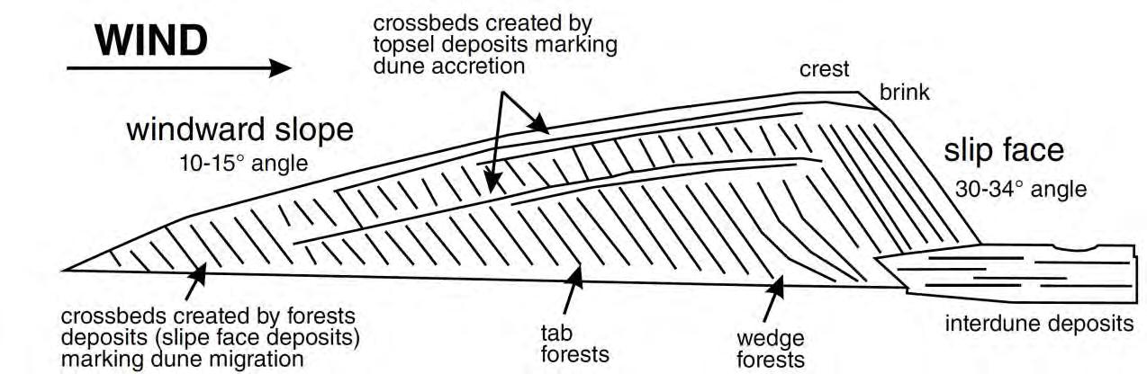
Active coastal dune systems are naturally dynamic and mobile systems that change over time through the action of wind. Windborne sediment transport drives changes in dune topography through the process of erosion and accretion. Transgressive coastal dune systems are a type of barrier dune that migrate landwards over time due to prevailing onshore winds. The movement of the sand dunes are influenced by wind direction, frequency and strength. Figure B-1 presents a schematic cross section that demonstrates typical transgressive dune. Newcastle Bight (Stockton Beach) has the largest actively mobile transgressive dune system on the NSW coastal zone.
Typical Dune Morphology (from Chevron, 2011)
Sand deposition can occur on the windward slope, causing the dune to build upwards (or accrete). Sand deposition can also occur on the leeward slope, causing the dune to build laterally (transgress) in a down wind direction. When the leeward slope becomes steepened to the angle of repose of dry sand (about 34°), sands literally fall (or slip) down the leeward slope and the dune moves forward as a whole (see Figure B-1). This over steepened leeward slope is also referred to as the dune ‘slip face’. The slip face depositional process (and dune form) is common for transgressive dunes built from prevailing onshore winds.
Dune erosion typically occurs on the windward slope of the dune. Progressive and persistent erosion can lead to formation of a dune deflation hollow along the downwind margins of the transgressive dune. This is a common feature within the Newcastle Bight transgressive dunes.
Sand drift is a known and documented “hazard” on the NSW coast, one that is required to be assessed when defining hazards in the coastal zone. Sand drift poses a nuisance where sand is being blown into developments, and a major risk where dunes are migrating to engulf houses and development.
Historically, the NSW Soil Conservation Service and others mitigated this risk by vegetating active and bare dunes, which captured and held the sand in place. This is suitable on a small(er) scale particularly for beaches with smaller sand dune reserves. However, there were some locations where stabilising the active dunes resulted in erosion of downdrift beaches because the coastal sand supply to these beaches occurred via the wind blowing sand along and through the active dunes.