9 minute read
Inundation Hazard Exposure and Damages Assessment


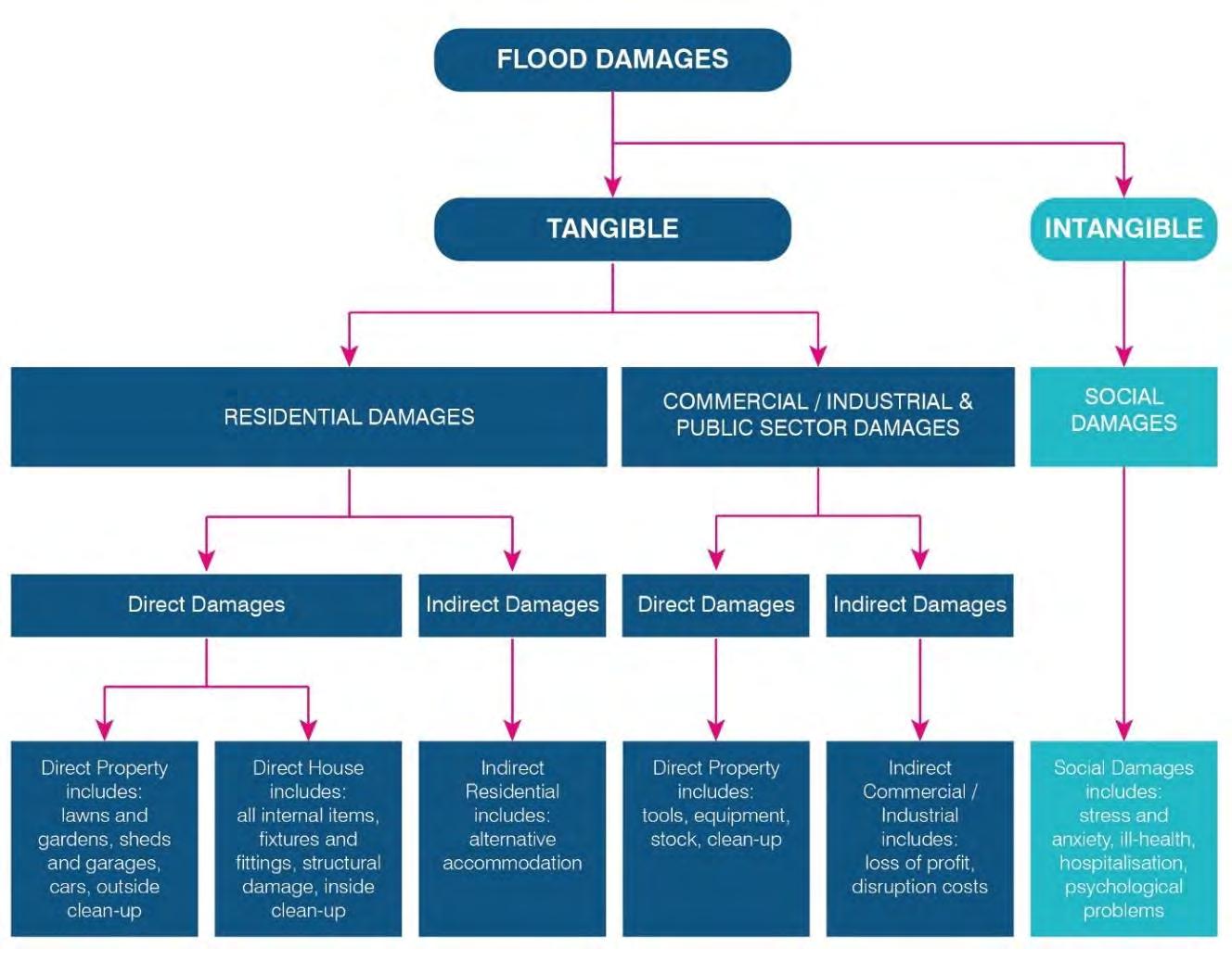
infrequently, there will be major flood damage (caused by large, rare flood events). Estimation of the AAD provides a basis for comparing the effectiveness of different floodplain management measures (i.e. the reduction in the AAD).
The assessment of the residential flood damages under existing climate conditions are presented in Table 9-5 Assessment of the residential flood damages under future 2040, 2070, 2120 conditions are presented in Table 9-6 to Table 9-8
*Wave Runup level (WRU) and Still Water level (SWL)
9.3.6 Property Inundation
A summary of the number of residential properties potentially affected by above floor flooding from still water and wave runup flooding for the 5% AEP, and 1% AEP, inclusive of SLR scenarios is shown in Table 9-9.
10 Conclusions and where to from here?
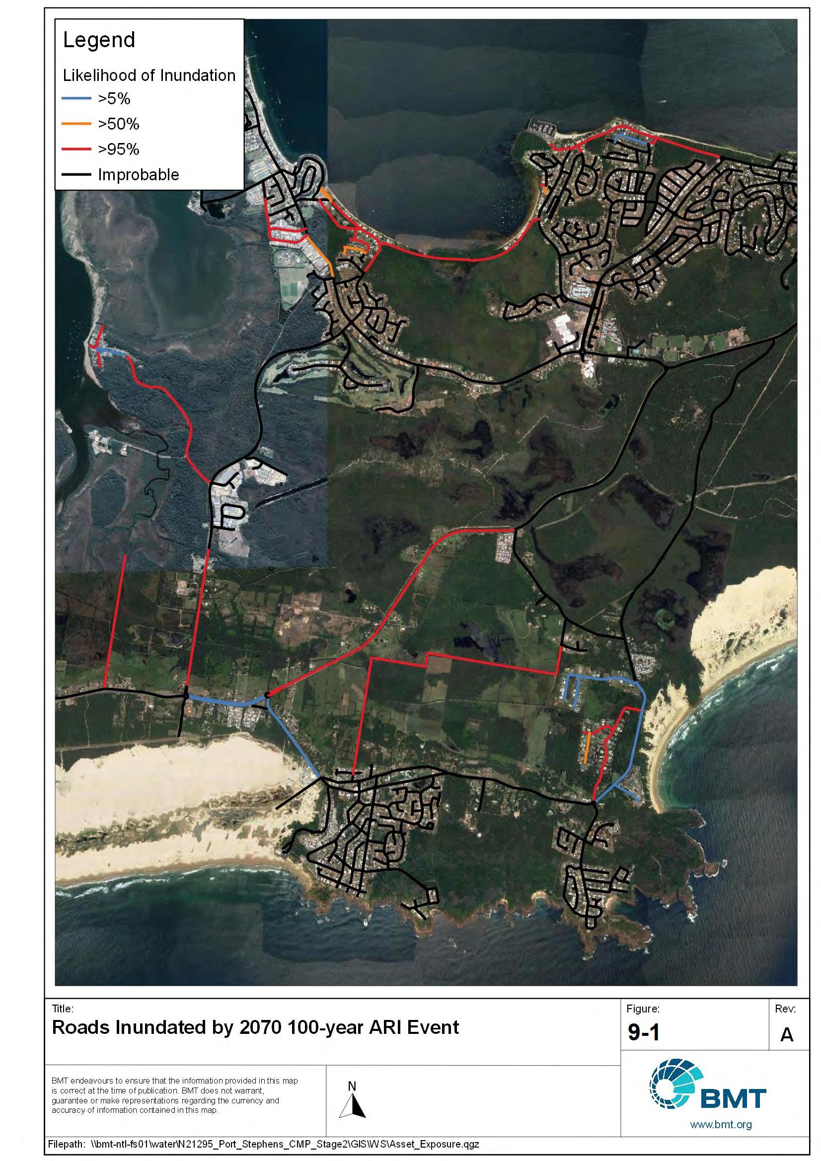
This report has detailed the coastal hazards (i.e., coastal erosion / recession, coastal inundation, tidal inundation, and dune transgression) and associated risks to land and assets (built and natural) on the Port Stephens coastline.
The next stage of preparation of the CMP is to use the hazard information to not only provide Council with an understanding of the assets at risk from coastline related hazards but use the mapping outputs to guide a full-scale detailed risk assessment for the coastal area.
Following the risk assessment, the CMP Stage 3 involves the Options Assessment, during which options for managing the high/extreme risks from coastal hazards and other issues affecting the Port Stephens coastline will be investigated. The risk assessment outcomes, as well as hazard mapping provided in this report will form key inputs to Stage 3 of the CMP preparation process.
Stage 3 will also assess these management measures against multiple criteria to provide a short-list of preferred actions for implementation (and will be fully documented in a Stage 4 report).
Finally, the coastal zone is defined under the CM Act as comprising four coastal management areas being, in order of priority, 1) the coastal wetlands and littoral rainforest area, 2) coastal vulnerability area, 3) coastal environment area, and 4) coastal use area. To date, the Coastal Management SEPP maps include only areas 1, 3 and 4. Stage 3 of this CMP will also provide an opportunity for Council to update the SEPP mapping to include any identified coastal vulnerability areas (area 2), using the newly developed hazard maps, through a planning proposal. It is important to define the vulnerability areas, particularly for development purposes. For example, individual landholders that have land within the coastal zone (or coastal vulnerability area) will be able to utilise the Stage 2 hazard study / mapping / CMP rather than having to complete their own vulnerability assessments.
11 References
Barnard, P.L., Hoover, D., Hubbard, D.M., Snyder, A., Ludka, B.C., Allan, J., Kaminsky, G.M., Ruggiero, P., Gallien, T.W., Gabel, L., McCandless, D., Weiner, H.M., Cohn, N., Anderson, D.L., and Serafin, K.A. 2017. ‘Extreme oceanographic forcing and coastal response due to the 2015–2016 El Niño’, Nature Communications, 8, 14365.
Barnard, P.L., Short, A.D., Harley, M.D., Splinter, K.D., Vitousek, S., Turner, I.L., Allan, J. Banno, M., Bryan, K.R., Doria, A., Hansen, J.E., Kato, S., Kuriyama, Y., Randall-Goodwin, E., Ruggiero, P., Walker, I.J., and Heathfield, D.K. 2015. ‘Coastal vulnerability across the Pacific dominated by El Nino / Southern Oscillation’, Nature Geoscience, 8, 801–808.
Belly, P., 1964. Sand movement by wind., s.l.: U.S. Army Corps of Engineers, CERC, Washington, DC. Tech. Memo. 1.
Bluecoast, 2020. Stockton Bight Sand Movement Study (Report #: P19028_R4.00). City of Newcastle, Newcastle.
BMT WBM, 2011. Halifax Park / Fly Point Sand Accumulation Study (No. R.2128.001.01). Newcastle, Port Stephens Council.
BMT, 2019. Fern Bay Dune Management Report, Newcastle: Seaside Village, Fern Bay.
Bruun, P., 1962. Sea-level rise as a cause of shore erosion. Journal of Waterways and Harbours, Volume 88, pp. 117-130.
Cardno, 2020. Coastal Processes Assessment, Melbourne: Bayside City Council.
CSIRO, 2020. Regional Sea Level Data. CSIRO Sea Level, Waves and Coastal Extremes. Available: https://research.csiro.au/slrwavescoast/sea-level/measurements-and-data/sea-level-data/
Davidson-Arnott, R. H. P. O. J. W. I. B. B. D.-F. I. S. T., 2018. Sediment Budget Controls on Foredune Height: Comparing Simulation Model Results with Field Data. Earth Surface Processes and Landforms, 43(9), pp. 1798-1810.
Dean, R. G., 1991. Equilibrium beach profiles - characteristics and applications. Journal of Coastal Research, Issue 7, pp. 53-84.
Delgado-Fernandez, I., 2011. Meso-scale modelling of aeolian sediment input to coastal dunes. Geomorphology, 130(3-4), pp. 230-243.
DHI, 2006. Stockton Bight coastal process study, Newcastle: Newcastle City Council, DHI.
Doyle, T. B., 2019. Foredune morphodynamics in New South Wales, Australia. Ph.D thesis, School of Earth and Environmental Science, University of Wollongong, Wollongong, Australia.
Doyle, T., Short, A., Ruggiero, P. & Woodroffe, C., 2019. Interdecadal Foredune Changes along the Southeast Australian Coastline: 1942–2014. Journal of Marine Science and Engineering, p. 177.
DPIE, 2018. NSW Marine LiDAR Dataset. s.l.:Department of Planning Industry and Environment.
Ferland, M. A., 1990. Shelf Sand Bodies in Southeastern Australia, Sydney: PhD Thesis; University of Sydney.
Fryberger, S. D. D., 1979. Dune forms and wind regime.. In: E. McKee, ed. A Study of Global Sand Seas.. Washington: Geological Survey Prof. Paper, 1052. US Govt. Printing Office, pp. 137-170.
Geomarine, 1987. Jimmys Beach nourishment impact assessment of dredging Paddy Marrs Bar, s.l.: s.n.
Geomarine, 1991. Engineering Studies for a Small Boat Harbour, Port Stephens, New South Wales. s.l., Coastal Engineering: Climate for Change; Proceedings of 10th Australasian Conference on Coastal and Ocean Engineering, 1991.
Goodwin, I., Burke, A., Mortlock, T., Freeman, R. and Browning, S. A., 2015. Technical Report of the Eastern Seaboard Climate Change Initiative on East Coast Lows Project 4: Coastal System Response to Extreme East Coast Low Clusters in the Geohistorical Archive, Sydney: Adapt NSW and Macquaire University.
Gordon, A., 2015. Hazard Lines - Last Century's Thinking. Auckland, NZ, Australasian Coast & Ports Conference.
Gordon, A. D. a. L. D. B., 1980. An approach to understanding coastal processes.. Sydney, pp 1235 - 1254, In: Proceedings of the 17th international conference on Coastal Engineering.
Gordon, A. D. R. P. S., 1977. Sand movement in Newcastle Bight, Melbourne: 3rd Australian conference on coastal and ocean engineering, Institution of Engineers Australia, pp 64 - 69.
Hallermeier, R. J., 1981. A Profile Zonation for Seasonal Sand Beaches from Wave Climate. Coastal Engineering, Issue 4, pp. 253-277.
Hanslow, D., 2007. Beach erosion trend measurement: A comparison of trend indicators. Journal of Coastal Research, pp. 588-593.
Harley, M.D., Turner, I., Short, A., and Ranasinghe, R. 2011. ‘A re-evaluation of coastal embayment rotation in SE Australia: the dominance of cross-shore versus alongshore sediment transport processes.’, Journal of Geophysical Research, 116(F4).
Harley, M.D., Turner, I.L., Short, A.D., and Ranasinghe, R. 2010. ‘Interannual variability and controls of the Sydney wave climate’, International Journal of Climatology, 30(9), 1322 -1335.
Harris, D. B. J. A. T. V.-C. A., 2009. Multi-scale morphodynamic assessment of an embayed low energy estuarine beach, Shoal Bay, Port Stephens, NSW.. Sydney, East Coast Conferences, p. 19.
IPCC, 2019. Summary for Policymakers. In: IPCC Special Report on the Ocean and Cryosphere in a Changing Climate. s.l.: Intergovernmental Panel on Climate Change.
Kinsela, M. A., Morris, B. D., Daley, M. J. A. & Hanslow, D. J., 2016. A Flexible Approach to Forecasting Coastline Change on Wave-Dominated Beaches. Journal of Coastal Research, Issue 74, pp. 952-956.
Kinsela, M. M. B. L. M. H. D., 2017. Second-Pass Assessment of Potential Exposure to Shoreline Change in New SouthWales, Australia, Using a Sediment Compartments Framework. Journal of Marine Science and Engineering, 5(61), p. 40.
Lord, D. W. P. K. N. P. A., 1995. Offshore Dredging for Beach Nourishment; Shoal Bay, NSW. Newcastle, Institute of Engineers, Australia.
McInnes, K. & Hubbert, G., 2003. A numerical modeling study of storm surges in Bass Strait. Aust. Met. Mag., Volume 52, pp. 143-156.
MHL, 1997. Port Stephens Flood Study - Stage 2, Design Water Levels and Wave Climate, s.l.: MHL.
MHL, 2002. Hunter Estuary Process Study Summary Report, Sydney: NSW Department of Public Works and Services; Manly Hydraulics Laboratory.
Miot da Silva, G. H. P., 2010. Coastline orientation, aeolian sediment transport and foredune and dunefield dynamics of Moçambique Beach, Southern Brazil. Geomorphology, 120(3-4), pp. 258-278.
Moore, L. J., 2000. Shoreline mapping techniques. Journal of coastal research, 16(1), pp. 111-124.
Moratti, M., 1997. Stockton Beach Erosion, Monitoring and Management. Christchurch, NZ, Combined Australasian Coastal Engineering and Ports Conference.
Mortlock, T.R., and Goodwin, I.D. (2015) ‘Directional wave climate and power variability along the Southeast Australian shelf’, Continental Shelf Research, 98, 36–53.
Nielsen, P. & Hanslow, D. J., 1991. Wave Run-up Distributions on Natural Beaches. Journal of Coastal Research, Issue 7(4), pp. 1139-1152.
NSW Government, 2020. Review of potential marine sand resources for beach renourishment in the Hunter–Newcastle region, s.l.: Regional NSW.
Office of Environment and Heritage (OEH), 2018. NSW Coastal Management Manual Part A: Introduction and mandatory requirements for a coastal management program. Sydney: OEH, NSW Government.
Oppenheimer, M. et al., 2019. Sea Level Rise and Implications for Low-Lying Islands, Coasts and Communities. In: IPCC Special Report on the Ocean and Cryosphere in a Changing Climate. Intergovernmental Panel on Climate Change.
Pearce, K. & Walker, I., 2005. Frequency and magnitude biases in the 'Fryberger' model, with implications for characterizing geomorphically effective winds. Geomorphology, pp. 39-55.
Port of Newcastle, 1993. Mobility Study, Dumped Dredge Spoil - Outline of Stage 1 and Stage 2 Study findings, Newcastle: MSB Hunter Ports Authority.
Port Stephens Council, 2019. Coastal Management Program Stage 1 - Scoping Study, Port Stephens: Port Stephens Council.
PWD, 1987. Jimmys Beach Erosion Study., Newcastle: NSW PUblic Works Department - report 85042.
PWD, 2000. Jimmys Beach Coastline Management Review, Conceptual Sediment Budget and Beach Nourishment Practices., Newcastle: NSW Public Works Department.
PWDS, 1999. Port Stephens/Myall Lakes Estuary Processes Study, Sydney: Department of Public Works, and Manly Hydraulics Laboratory.
Ranasinghe, R., McLoughlin, R., Short, A., and Symonds, G. (2004) ‘The Southern Oscillation Index, wave climate, and beach rotation’, Marine Geology, 204(3–4), 273–287.
Royal Haskoning DHV, 2016. Little Beach Coastal Process Study, Newcastle, Australia: Port Stephens Council.
Roy, P. B. R., 1996. Quaternary geology of the southeast Australia: a tectonically stable, wavedominated, sediment deficient margin., Sydney: IGCP project # 367, Field Guide to the central New South Wales coast, NSW Geological Survey.
Roy, P. C. E. A., 1980. Quaternary geology of the Newcastle Bight Inner Continental Shelf, NSW, Australia, Sydney: NSW Geological Survey Records 19 (2), 145 - 188.
Roy, P. S. C. E. A., 1979. Quaternary geology of the Newcastle Bight inner continental shelf, NSW. NSW Geological Survey Records , 19(2), pp. 145 - 188.
Shand, T.D., Goodwin, I.D., Mole, M.A., Carley, J.T., Browning, S., Coghlan, I.R., Harley, M.D., and Peirson, W.L. 2011. NSW Coastal Inundation Hazard Study : Coastal Storms and Extreme Waves
Short, A., 2007. Beaches of the New South Wales coast: a guide to their nature, characteristics, surf and safety, 2nd edn.. Sydney: Sydney University Press.
Short, A., 2020. Southern NSW Region. In: C. R. Library, ed. Australian Coastal Systems - Beaches, Barriers and Sediment Compartments. Switzerland: Springer, pp. 601- 682.
Short, A. D. and Thom, B. G., 2018. Australian/NSW coastal sediment compartments. Concept and application. Merimbula, NSW, 27th NSW Coastal Conference.
Short, A.D., and Trenaman, N.L. 1992 ‘Wave climate of the Sydney region, an energetic and highly variable ocean wave regime’, Marine and Freshwater Research, 43(4), 765–791.
Stockdon, H. F., Holman, R. A., Howd, P. A. & Sallenger, A. H., 2006. Empirical parameterization of setup, swash and runup. Coastal Engineering, Issue 53, pp. 573-588.
Thom, B. et al., 2018. National sediment compartment framework for Australian coastal management. Ocean and Coastal Management, Volume 154, pp. 103-120.
Thom, B. S. M. L. C. R. P. B. G. H. P., 1992. Coastal Geomorphology and Quaternary Geology of the Port Stephens-Myall Lakes Area, Canberra: Department of Biogeography and Geomorphology, Australian National University, Monograph No 6.
Treloar, P. D. A. C. L., 1977. Investigation into the Cause of Severe Waves at the Entrance to Newcastle Harbour. Wallingford, U.K, Third Australian Conference on Coastal and Ocean Engineering, 1977: The Coast, the Ocean and Man, The. Barton, A.C.T.: Institution of Engineers, Australia.
Turner, I.L., Harley, M.D., Short, A.D., Simmons, J.A., Bracs, M.A., Phillips, M.S., and Splinter, K.D. 2016. ‘A multi-decade dataset of monthly beach profile surveys and inshore wave forcing at Narrabeen, Australia.’, Scientific data, 3, 160024.
Umwelt, 2002. Shifting sands at Stockton Beach, Toronto, NSW: SMEC and Newcastle City Council.
Wainwright, D. L. D. C. B., 2015. 40 Years of Change - Recent Evolution of the Port Stephens Flood Tide Delta. Forster, East Coast Conferences .
Watson, P., 1997. Port Stephens Sand Nourishment Projects - Evaluation, Monitoring & Sustainability. Christchurch, New Zealand, Centre for Advanced Engineering, pp. 453-458.
WBM, 1998. Newcastle Coastline Hazard Definition Study, Newcastle: Newcastle City Council.
WMAwater, 2002 Port Stephens Foreshore Floodplain Management Study and Plan. For Port Stephens Council.
WMAWater, 2010. Port Stephens Design Flood Levels Climate Change Review, for Port Stephens Council.
WorleyParsons, 2012. Stockton Beach Sand Scoping and Funding Feasibility Study, Sydney: Newcastle City Council.
WRL, 2011. NSW Coastal Inundation Hazard Study: Coastal Storms and Extreme Waves, Manly Vale, NSW: Water Research Laboratory - University of New South Wales.
Zingg, A., 1953. Wind tunnel studies of the movement of sedimentary material.. Iowa City, USA, Institute of Hydraulics, pp. 111-135.