

Document Revision
R
Document Revision
R

Document Reference Date Amendments
0 J1801113 001 R Rev0 7 December 2022
1 J1801113 001 R Rev1 16 March 2023
2 J1801113 001 R Rev2 31 March 2023
3 J1801113 001 R Rev3 10 May 2023
4 J1801113 001 R Rev4 10 May 2023
5 J1801113 001 R Rev5 24 May 2023
6 J1801113 001 R Rev6 26 May 2023
7 J1801113 001 R Rev7 27 June 2023
8 J1801113 001 R Rev8 3 August 2023
9 J1801113 001 R Rev9 9 August 2023
10 J1801113 001 R Rev10 10 August 2023
11 J1801113 001 R Rev11 10 August 2023
Submitted for client and Auditor review
Revised based on Auditor and DWER comments
Updated based on Auditor comments
Updated based on Auditor comments
Updated based on client comments
Updated based on Auditor comments and additional developer commitments
Updated based on Auditor comments
Updated based on Auditor comments
Updated based on DWER/DoH comments
Updated based on Auditor comments
Updated based on Auditor comments
Updated based on Auditor comments
12 WAE180113 009 R Rev0 2 July 2024 Updated to include Stage 1C
13 WAE180113 009 R Rev1 25 July 2024
14 WAE180113 009 R Rev2 30 January 2025
15 WAE180113 009 R Rev3 18 February 2025
Updated based on Auditor comments
Updated based on Regulator comments
Updated based on Auditor comments
TABLES
Table 1: Site Identification – Kinmore Green 3
Table 2: Roles and Responsibilities – Stages 1B, 1C, and 2...............................................................................................10
Table 3: Roles and Responsibilities – Kinmore Green Residential Estate 14
FIGURES
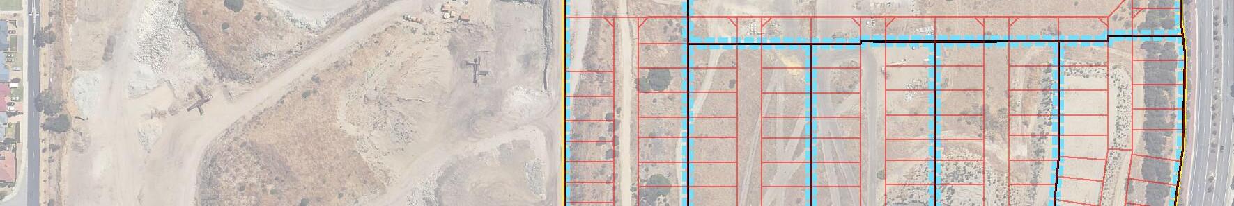
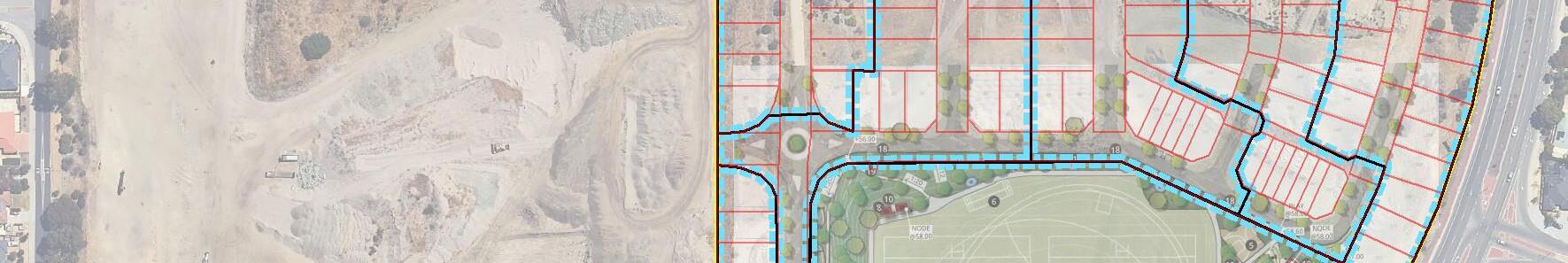
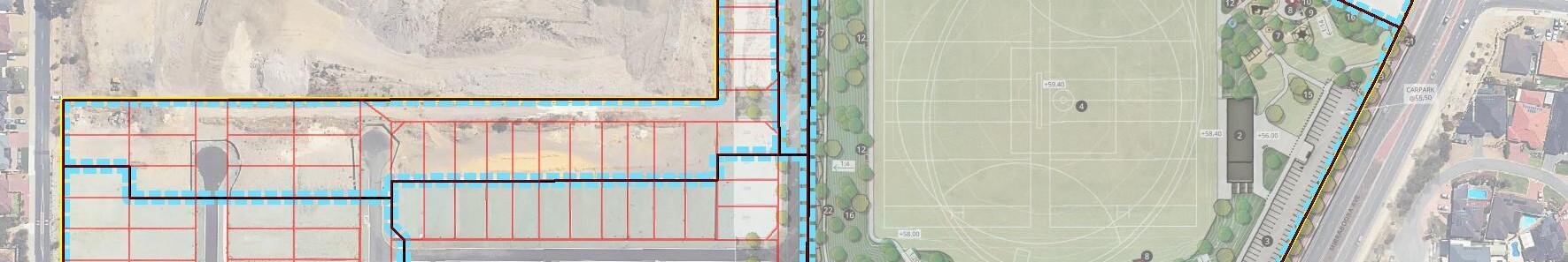
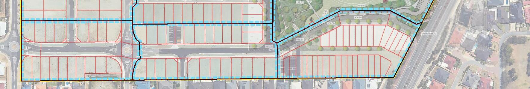
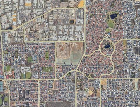
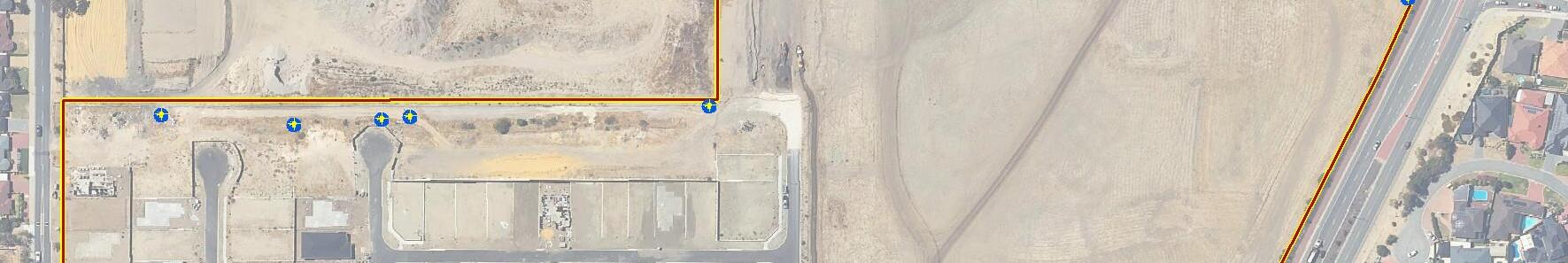
FIGURE 1: Extent of Stages 1B and 2
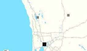
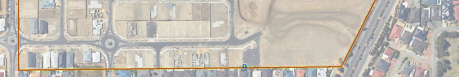
FIGURE 2: Extent of Kinmore Green Residential Estate
APPENDICES
APPENDIX A: DEPOSITED PLANS
APPENDIX B: STRUCTURE PLAN
APPENDIX C: PREVIOUS REPORTS
APPENDIX D: AS CONSTRUCTED DRAWINGS – LIMESTONE RAFT AND GRMS
APPENDIX E: RESTRICTIVE COVENANTS
APPENDIX F: LOT PLANS
APPENDIX G: GROUNDWATER AND LANDFILL GAS SAMPLING ANALYSIS AND QUALITY PLAN
APPENDIX H: PARCEL DARCH PTY LTD LETTERS OF COMMITMENT
APPENDIX I: INFORMATION BROCHURE FOR RESIDENTS AND STAKEHOLDERS
APPENDIX J: UNDERSTANDING YOUR REPORT
This report presents Galt Environmental Pty Ltd’s (Galt’s) ongoing site management plan (OSMP) for Stages 1 & 2 of Kinmore Green Residential Estate located at 46 Driver Road, Darch (the site). Additionally, this OSMP includes ongoing management measures for the overall Kinmore Green Residential Estate. The OSMP will be reviewed and updated annually, or as subsequent stages are completed.
The overall proposed development comprises construction of residential lots, associated road reserves, public open space (POS) and a commercial precinct.
This plan has been developed to facilitate ongoing management of the site (post construction) in context of the risks associated with historical landfill material at the site. Furthermore, the OSMP has been developed to protect human health by establishing conditions or guidelines for ongoing use of the site in order to protect the gas risk mitigation system (GRMS) which underlies the remediated (‘made ground’) from damage/breaches. The OSMP will be used to guide the ongoing use of the broader site and provide guidance to:

individual lot owners to manage residential/commercial lots; the local government authority (LGA) to manage land parcels including public open spaces (POS)and roads/reserves; and utilities/services and other future workers at the site.
This document must be provided to all (current and future) individual lot owners, responsible parties and body corporates within the Kinmore Green Residential Estate. Furthermore, a Form 6 – Landowner’s Disclosure Before Completion of Land Transaction under Section 68 of the Contaminated Sites Act 2003 must be required to facilitate the change of land ownership.
The structure of the OSMP is in accordance with the Department of Water and Environment Regulation (DWER) (2021) Assessment and Management of Contaminated Sites, under the Contaminated Sites Act 2003 and has been designed for implementation in perpetuity.
This OSMP has been developed specifically for landowners in Stages 1 and 2 and focuses on the responsibility of induvial residential landowners within these stages. Additionally, this OSMP includes management measures to be implemented by the developer, Parcel Darch Pty Ltd. for the overall Kinmore Green Residential Estate
It should be noted that a separate OSMP is being prepared for the POS. This OSMP will be prepared by Parcel Darch Pty Ltd for City of Wanneroo to sign-off prior to acceptance of the land.
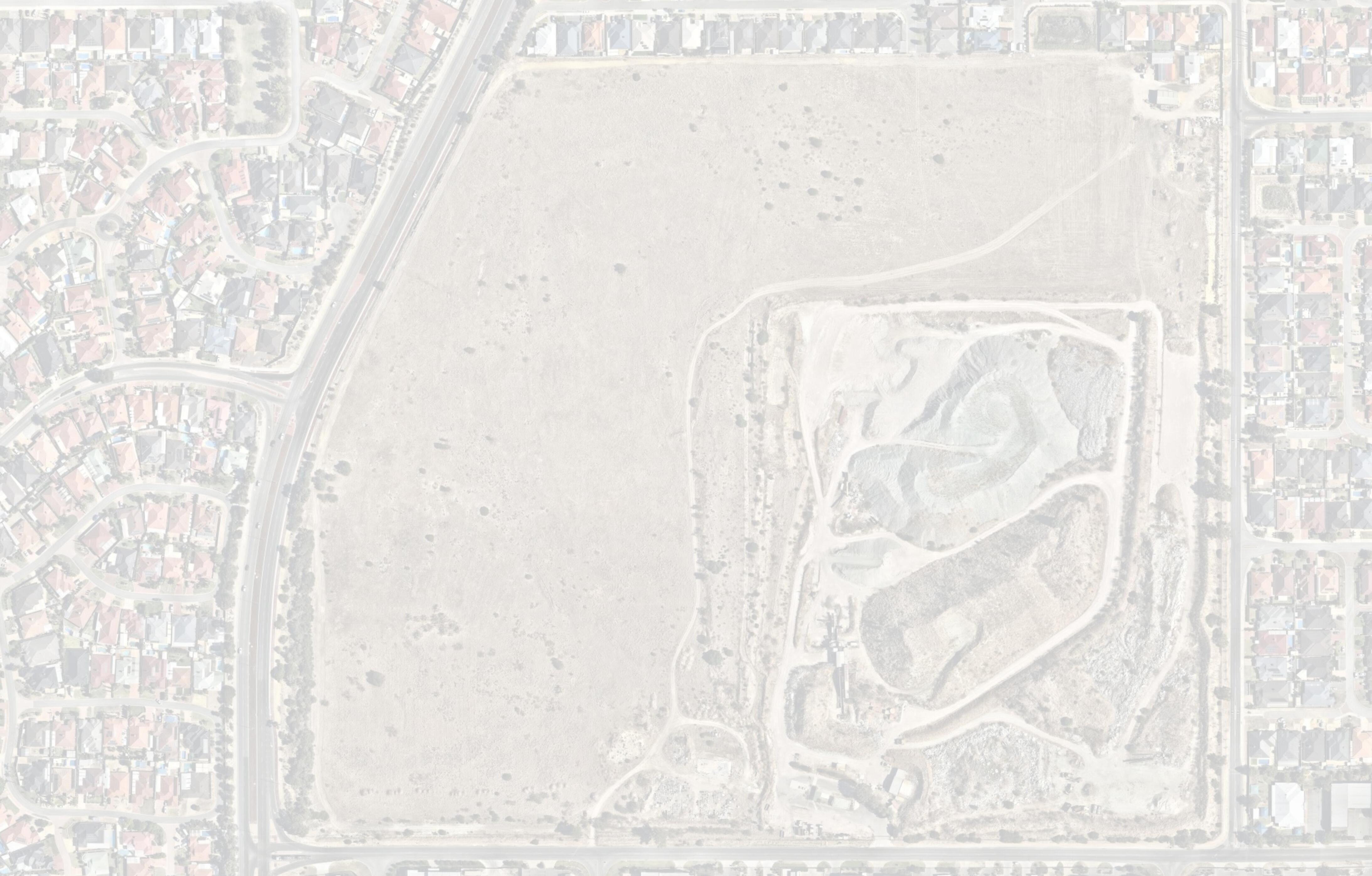
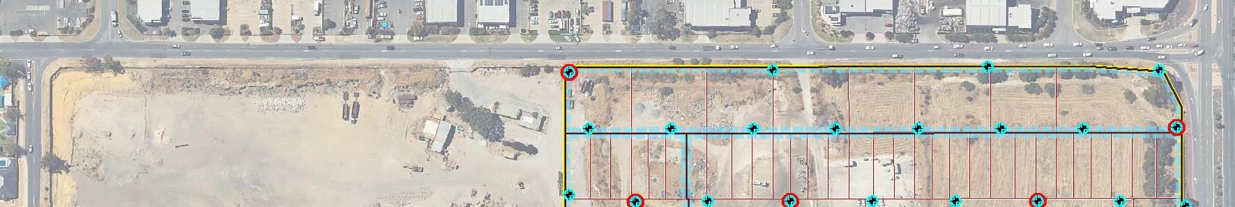
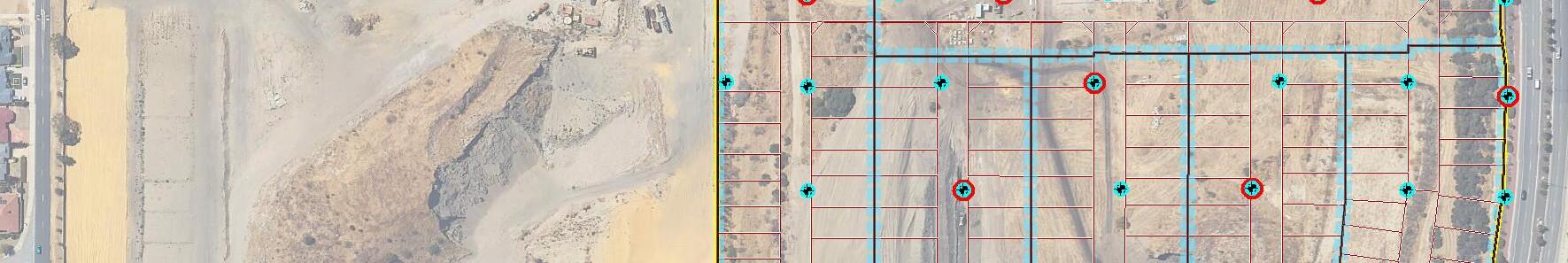
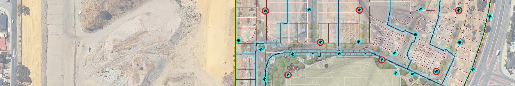
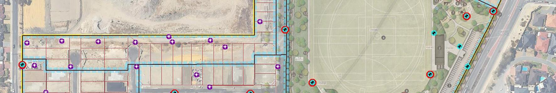
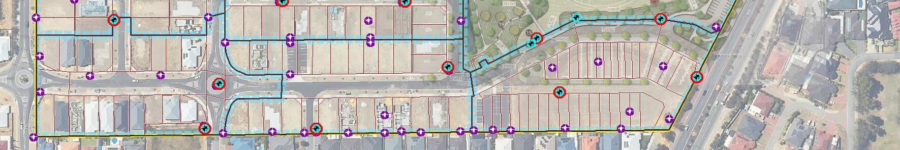
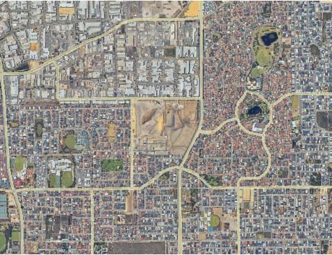
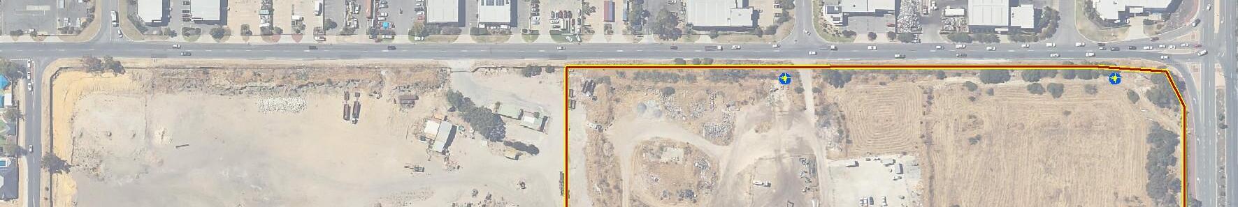
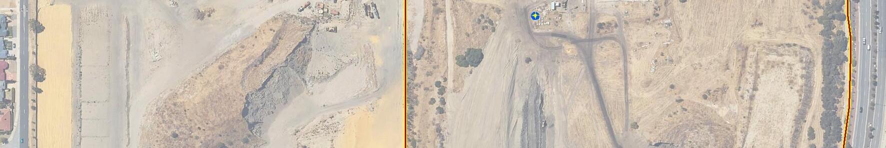
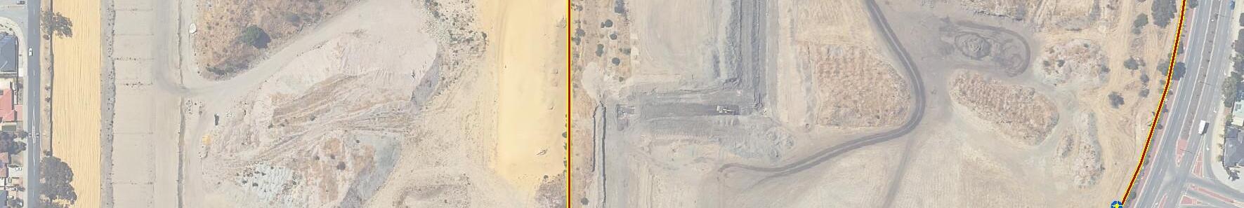
The extent the Stages 1 and 2 with boundary coordinate are shown on Figure 1. Deposited plans for Stages 1 and 2 indicating proposed lot numbers are provided in Appendix A. The extent of the Kinmore Green Residential Estate is shown on Figure 2. The overall Structure Plan for the Estate is provided in Appendix B
The Kinmore Green Residential Estate forms part of the previous Lot 8000, which incorporated the current Lot 2 (subject site) and the adjacent Lot 1, which is located to the northwest of the subject site.
Lot 2 was originally mined for sand supplies for the building and construction industry. Upon completion of quarrying activities, the site operated as a non-organic waste disposal facility (mainly building rubble). The site has now been entirely filled apart from the adjacent Lot 1 (note: Lot 1 is not considered part of this study).
17 February 2025
Progressive filling of Lot 2 began in about 1989, initially in the northeast corner, then along the eastern boundary. The filling process to the west and along the eastern boundary (south of the northeast corner of fill) was inspected on an ongoing basis by Soil and Rock Engineering Pty Ltd (SRE). A section in the southwest corner of the site adjacent Driver Road was also filled under the direction of SRE personnel.
It is understood that the majority of the initial fill was placed in accordance with City of Wanneroo requirements, initially under the guidance of City of Wanneroo personnel, then by SRE for a number of years. We also understand that records for this phase of the work have been lost.
We further understand that the remaining area (southern section) was:
progressively filled with non-organic waste processed through a crushing plant; and filled in an engineered manner which involved placing in loose layers up to about 0.5 m thick and compacting using multiple passes of rubber tired and tracked earthmoving equipment inclusive of a rubbish compactor.
The site, with the exception of Stages 1 and 2, is currently classified as Contaminated – remediation required under the Contaminated Sites Act 2003 (the Act). The site was classified under Section 13 of the Act to reflect additional technical information supplied to the Department of Water and Environmental Regulation (DWER) by July 2021. The technical information was outlined in a mandatory auditor’s report (MAR) based on the findings of the 3-part DSI (see Appenidx B for references)
Stages 1A, 1B, 2A and 2B have be reclassified as ‘Remediated for restricted use’ with a restriction on abstraction of groundwater for any purpose other than analytical testing.
The site was first classified under Section 13 of the Contaminated Sites Act, 2003 based on information supplied to the Department of Environment and Conservation (DEC) by September 2008.
The aim of the development is to make the site suitable for the proposed use (in context of the existing gas, soil and groundwater conditions) and facilitate reclassification under the CS Act as Remediated for restricted use (RRU) for Stages 1 and 2. It is anticipated that reclassification of future stages to RRU will be achieved following further remedial works and implementation of OSMPs
A number of previous reports and supplied information have been provided and used during the course of the site investigation and remediation works. The reports are listed in Appendix C
A copy of the reports above may be obtained by any landowner upon request to Parcel Darch Pty Ltd or by submitting a detailed summary of records (DSR) request through DWER1
The objectives of the OSMP are as follows:
provide an appropriate methodology for soil disturbing works across the site i.e. during construction (installation of buried services beneath individual residential/commercial lots) and/or future maintenance/repair works; provide restrictions on excavation depth across the site based on the subsurface conditions;
1 Fees are associated with submitting a DSR search request.
ensure protection of the gas risk mitigation system (GRMS) in order to protect human health by establishing guidelines for ongoing site use; provide recommendations on the use of groundwater beneath the site; and to detail the management responsibilities for both Stages 1 and 2 and the Kinmore Green Residential Estate as a whole
The site location and boundary coordinates of Kinmore Green are shown in Figure 1 and summarised in Table 1
Table 1: Site Identification – Kinmore Green
Site Identification
Street Address
46 Driver Road
Locality Darch, 6065
Legal Identification (Parent Lot) Lot 9000
Local Government City of Wanneroo
Boundary Coordinates (MGA 94) See Figure 1
Area (Parent Lot)
Current Zoning
Current Landowner
Proposed Land Use
Stage 1A Lots
Stage 1B Lots
Stage 1C Lots
Stage 2A Lots
Stage 2B Lots
Current Site Classification (Stages 1A, 1B, 2A, 2B)
Current Site Classification (balance of the site)
Proposed Site Classification (Stages 1C)
24.7 ha
Zoned as ‘Urban Development’ under the City of Wanneroo District Planning Scheme No. 2 (DPS2)
Parcel Darch 2019 Pty Ltd
Mixed use residential and public open space (POS)
Lots 186-189, 204-207, 267-276, and 291
Lots 277-288, 254-266
Lots 1-15, 17-34
Lots 181-193, 200-203, 208-211
Lot 226-253
Remediated for restricted use
Contaminated – remediation required
Remediated for restricted use
Deposited plans for Stages 1 and 2 are provided in Appendix A
The following lot release for Stages 1 & 2 are as follows:
Stage 1: 43 lots total
o Stage 1A: 18 Lots (no GRMS required)
o Stage 1B: 23 Lots (GRMS installed)
o Stage 1C: 33 Lots (GRMS) installed)
Stage 2: 45 Lots (GRMS installed)
17 February 2025
Lots in Stages 1B, 1C and 2 that are underlain by a GRMS are shown on as-constructed drawings provided in Appendix D
Approximate timing for construction of the various Stages is provided below.
Stage 3, 4 and part of 7 and 8 – Q3/Q4 2024 – Q2 2025
Stage 1C – Completion Q3 2024
Public Open Space – Q3/Q4 2024
Stage 3 civil works – Q1/Q2 2025
Stage 4 civil works – Q1/Q2 2025 (will be done same time as 3)
Stage 5, 6, and part of 7 – Q3 2025
Commercial precinct – Q3/Q4 2025
Stage 5 civil works – Q3/Q4 2025
Stage 6 civil works – Q3/Q4 2025
Stage 8 and 9 – timing unknown as reliant on interface with Lot 1 Driver Road works (Note: portion of Stage 9 to be earthworked during Stage 3 to facilitate installation of GRMS.
Future lot releases will be outlined at the time of the stage release by the developer and updated in a separate OSMP for prepare for each area accordingly.
The DWER contaminated sites database indicates that the majority of the Kinmore Green Residential Estate is classified as ‘Contaminated – remediation required’ as of November 2022. Stages 1A, 1B and 2 have recently be reclassified as ‘Remediated for restricted use’.
The following restriction is applicable to Stages 1A, 1B and 2:
Groundwater Abstraction
Ground water abstraction of the underlying aquifer is prohibited on each of the development Lots. This includes and not limited to ground water bores used for reticulation or irrigation within a Lot and/or groundwater abstraction for human consumption.
The following restriction is applicable to Stages 1B and 2 in addition to the restriction above:
Excavations
Excavations or intrusive works are limited to the top 2.0 m of the soil profile. Excavations below this level are not permitted due to the presence of the GRMS and the risk of potential damage to the membrane (thus presenting a hazard to human health via vertical gas migration). Excavation to a maximum depth of 2.0 m will ensure there is a minimum of 0.2 m of in situ material over the upper level of the GRMS at all times. All ground disturbing activities are limited to the excavation restrictions, including the following commonly undertaken on residential sites: gardening; underground installations (e.g. water connections, swimming pools, additional soak wells footings for patios/pergolas or similar); and repairs and maintenance (typically services).
17 February 2025
All lots have a 1 m wide ‘no build zone’ at the rear of the property (or in a few instances, a side boundary). This area is to be keep free of all habitable structures and sealed surfaces. This area is to remain as a passive venting zone in perpetuity.
It is anticipated that the following memorials on title (MoT) will be applicable to each lot within Stages 1C.
Ground water abstraction of the underlying aquifer is prohibited on each of the development Lots. This includes and not limited to ground water bores used for reticulation or irrigation within a Lot and/or groundwater abstraction for human consumption.
Excavations or intrusive works are limited to the top 2.0 m of the soil profile. Excavations below this level are not permitted due to the presence of the GRMS and the risk of potential damage to the membrane (thus presenting a hazard to human health via vertical gas migration). Excavation to a maximum depth of 2.0 m will ensure there is a minimum of 0.2 m of in situ material over the upper level of the GRMS at all times. All ground disturbing activities are limited to the excavation restrictions, including the following commonly undertaken on residential sites: gardening; underground installations (e.g. water connections, swimming pools, additional soak wells footings for patios/pergolas or similar); and repairs and maintenance (typically services).
All lots have a 1 m wide ‘no build zone’ at the rear of the property (or in a few instances, a side boundary). This area is to be keep free of all habitable structures and sealed surfaces. This area is to remain as a passive venting zone in perpetuity.
8.1 Overview
A summary of site soil, groundwater and landfill gas conditions relevant to this OSMP are presented in the following sections.
8.2 Soil
All residential lots within Stages 1B, 1C, and 2 are underlain by a minimum of 2.2 m of sand capping material to create an effective barrier between uncontrolled fill and sensitive receptors.
A limestone raft co-located with a gas risk mitigation system (GRMS) has been constructed at a depth not less than 2.2 m below finished lot levels. The limestone raft has been constructed to ensure the site is geotechnically suitable in context of the proposed development
Previous studies indicate that uncontrolled fill has been shown to be present across large portions of the site. However, the pathway between onsite sources and receptors has been removed through construction of the limestone raft,
17 February 2025
installation of GRMS, and placement of a 2.2 m thick sand capping layer. As such, the presence of potential contaminants within the uncontrolled fill is not considered to present a risk to onsite receptors.
The as-constructed drawings showing the location of the limestone raft are shown in Appendix D
Galt Environmental (2021b) indicates:
the groundwater flow direction is south southwest; dissolved metals (arsenic, boron, copper, iron, mercury, nickel, zinc) exceeded the freshwater (FW) criteria at the majority of monitoring wells; sulfate, dissolved metals (arsenic and nickel), and PFHxS plus PFOS exceeded the relevant drinking water (DW) criteria at a number of locations across the site; dissolved iron exceeded the short-term irrigation (STI) criterion of 10 mg/L at MW04; concentrations of dissolved arsenic and nickel exceeded the STI criteria during the first groundwater monitoring event (GME) but were either below the laboratory LOR or conformed to the adopted criteria during the second GME; groundwater at the site is not considered to present a risk to the environment in the context of the proposed land use; groundwater at the site is not considered suitable for use as a drinking water source or for domestic irrigation; and groundwater at the site is considered suitable for irrigation of POS.
The classification of the site under the Contaminated Sites Act 2003 restricts the use of groundwater within residential and commercial lots for any purpose other than for analytical testing
Galt Environmental (2021a) indicates there are elevated concentrations of methane and carbon dioxide in the ground primarily attributed to the green waste (grass) contained within the construction and demolition waste and sand fill, but there is no evidence of large-scale pressure driven (advective) flow (evidenced by the extensive gas monitoring data). Importantly, there is no evidence of material that could drive gas out of the ground in large volumes. This conclusion is consistent with the nature of the material, the gas generation assessment (reported separately) and lack of significant lateral migration.
The assessment indicates the on-site future landfill gas risks across the entirety of the Kinmore Green Residential Estate fall within a Very Low and Low risk regime. Despite the gas generation assessment suggesting slightly higher vertical gas emissions, the quantitative gas modelling showed equilibrium indoor methane concentrations are unlikely to exceed the adopted action level (5,000ppm) even without any building gas protection measures.
Other key risk considerations identified in the conceptual site model (namely, potentially higher landfill gas regimes via barometric pumping and sensitivity of the proposed development) indicates the potential for unacceptable gas intrusion risks only where the proposed buildings are constructed directly above the landfill waste materials. It was therefore recommended that gas protection measures be installed beneath future residential buildings only where the buildings are located above landfill waste materials. The gas protection measures included one level of protection (i.e., a geomembrane) in addition to the sand cap, which will, in practice, behave as a biocover. To minimise opportunity for future tampering, a single deep geomembrane barrier has been installed rather than protection measures in each building.
The Structure Plan for the Kinmore Green Residential Estate has been endorsed by the Western Australian Planning Commission (WAPC) and administered City of Wanneroo. No amendments to this scheme, such as changing the area dedicated to public open space, can be considered without review and endorsement of WAPC on advice from key regulatory agencies such as DWER. Therefore, it is not envisaged that the built form of the Estate will in any way change from the approved plan. As such, the main venting zone through the POS will always remain in place ensuring that the overall gas regime does not adversely impact surrounding residents.
9.1 Stages 1B, 1C & 2
9.1.1 Soil
Stages 1B, 1C, and 2 are suitable for residential purposes following completion of the remediation works. The ongoing site management measures required are as follows:
Excavation for development of individual residential lots is limited to the upper 2.0 m of the soil profile (providing a separation of 0.2 m to the GRMS at all times). This includes excavation for services and any accessory development features such as swimming pools, spas, soakwells etc. We note that basement garages or similar would likely be not achievable based on the permissible excavation depth.
No penetration of the GRMS is permitted for any purpose.
All municipal services for Stages 1B, 1C, and 2 will be installed within the upper 2 m of the soil profile eliminating the need for maintenance or repair works close to or below the GRMS.
Registration of a Restrictive Covenant on all Lots within Stages 1B. 1C, and 2 by Landgate relating to ground disturbing works on each certificate of title of lots. This is to ensure the current and future landowners (if any) are aware of the restrictions relating to planning/development at their sites. Furthermore, the restrictive covenant will be incorporated into LGA planning systems, thereby restricting approval of unsuitable development features that may interfere with the GRMS. The restrictive covenant will also ensure that the there are no significant changes to finished lot levels across the site and thereby preserve the separation of buildings from the GRMS.
As demonstrated in the development specific landfill gas risk assessment (DSLFGRA), the on-site future landfill gas risks across the entirety of the Kinmore Green Residential Estate fall within a Very Low and Low risk regime. As such, minor excavations for features such as swimming pools, spas, soakwells within the sand cap are acceptable. We also note that the Restrictive Covenant will remain on title information in perpetuity and cannot be lifted.
It is noted that soakwell construction will be undertaken in accordance with the Urban Water Management Plan (UWMP) (Urbaqua, 2021) prepared for the site and endorsed by the City of Wanneroo on advice from DWER. The UWMP shows soakwells installed directly into the sand cap with separation from the GRMS. The soakwells are only backfilled with lot-derived sand.
Given the soakwells are:
i. installed above the GRMS;
ii. backfilled with lot-derived sand; and
iii. outside the building footprint on each lot;
it is not considered possible for preferential LFG pathways to exist.
Further noted in the UWMP, the limestone rafts between lots are graded at 1:100 slope towards the road reserve to prevent any ponding of infiltrated water on top of the GRMS.
Given that groundwater beneath the Stages 1 and 2 is not considered suitable for drinking water or residential irrigation purposes, registration of a memorial with Landgate restricting groundwater abstraction will be place on each certificate of title of lots sold within the residential portion of the site. This is to ensure the current and future landowners (if any) are aware of the restrictions relating to using groundwater from the superficial aquifer for domestic purposes at their sites. Furthermore, the memorial will be incorporated into regulatory databases and water extraction licencing systems preventing approval of extraction bores across the site.
A groundwater monitoring program will be implemented to ensure: concentrations of COPC in groundwater remain, at a minimum, consistent 2with the current understanding of groundwater quality beneath the site; and short- and long-term protection of identified receptors from COPC in groundwater.
Ongoing groundwater monitoring will also provide additional information relating to the suitability of groundwater for beneficial uses
The methodology for groundwater monitoring is presented in a sampling analysis and quality plan (SAQP) provided in Appenidx G
As demonstrated in DSLFGRA, the on-site future landfill gas risks across Stages 1B, 1C, and 2 fall within a Very Low and Low risk regime.
The DSLFGRA identified that there are elevated concentrations of methane and carbon dioxide in the ground primarily attributed to the green waste (grass) contained within the construction and demolition waste and sand fill, but there is no evidence of large-scale pressure driven (advective) flow (evidenced by the extensive gas monitoring data). Importantly, there is no evidence of material that could drive gas out of the ground in large volumes. This conclusion is consistent with the nature of the material, the gas generation assessment (reported separately) and lack of significant lateral migration.
The risk assessment gas generation model indicated that slightly higher vertical gas emissions were possible. However, the quantitative gas modelling showed equilibrium indoor methane concentrations are unlikely to exceed the adopted action level (5,000ppm) even without any building gas protection measures.
In Stages 1B, 1C, and 2, a GRMS has been locally (to alter the vertical migration of landfill gas such that it is directed away from building footprints within each lot. The GRMS has been designed such that there is a passive venting zone at the rear of each lot(s) over which the main building is not permitted to be constructed under a Restrictive Covenant that has been placed on the lots. This will ensure that the site-wide gas regime is not materially changed.
Information provided to landowners in Stages 1B, 1C, and 2 includes the following:
Lot plan indicating the location of the GRMS beneath the lot;
A 1 m wide ‘No build zone’ required for passive venting typically at the rear of each lot.
Maintaining the broad soil type within the setback and road reserves i.e. ensuring that sand (as described by AS 1726) is the primary fill material.
2 Fluctuations of field parameters and laboratory results are highly likely due to the heterogeneous nature of the superficial aquifer and interaction of groundwater with the overlying landfill waste mass
17 February 2025
Maintaining the 2.2 m separation from the underlying GRMS.
This information is provided in a brochure that will be provided to all residents within Stages 1B, 1C, and 2 and on lot plans provided to each purchaser at the time of signing a sales contract
A copy of the restrictive covenant is provided in Appendix E Lot plans showing the geomembrane and passive venting zones for all lots covered by this OSMP are provided in Appendix F.
GRMS Location
A drawing showing the general cross section of the GRMS is shown in Inline Image 1 below. As-constructed survey drawings showing the location and extent of the GRMS including the passive venting zones (i.e. portions of the lots not underlain by a GRMS) are shown in Appendix D The GRMS QA validation report is separately provided as part of the remediation and validation report (RVR) (available from Parcel Darch Pty Ltd upon request or from DWER via a detailed summary of records search).
GRMS Breach
For the purposes of this OSMP, breaches of the GRMS will be categorised as follows:
Type 1 Breach: a small partial or full penetration of the cushion geotextile, geomembrane and separation geotextile layers (as shown in Inline Image 1 above) outside the building envelope.
Type 2 Breach: a small partial or full penetration of the cushion geotextile, geomembrane and separation geotextile layers within the building footprint.
If a Type 1 breach to the GRMS does occur (in contravention of this OSMP, restrictive covenant, and CoT memorial), it is not anticipated that repair of the membrane will be required due to the following:
very low and low gas risk shown to be present at the site; and the breach will have occurred outside any habitable areas during excavation for a swimming pool and/or installation of an irrigation bore
In the event of a Type 2 breach of the GRMS, Parcel Darch Pty Ltd, in consultation with the landowner, will be responsible for assessment, management, and remediation (if required) of the GRMS. If required, a targeted risk assessment will be undertaken to characterise whether the breach represents a risk to human health prior to repairs and/or remediation
being undertaken. The outcomes of this risk assessment and/or repairs/remediation will be provided to DWER, and the Auditor as required.
Any breach of the GRMS (Type 1 or Type 2) must be reported to Parcel Darch Pty Ltd, the Auditor, and DWER. DWER must be contacted within 24 hours via their 24-hour hotline (1300 762 982) or via email at info@dwer.wa.gov.au
Following installation of the GRMS, a tiered approach to landfill gas monitoring will be implemented, which includes:
Installation of monitoring wells immediately above the GRMS, typically within a lot; Installation of monitoring wells within passive venting zones, typically at lot boundaries; Monitoring in selected utility boxes (e.g. Telstra pit); and
Installation of deeper wells with the screen extending through the full thickness of the landfill mass. Deployment of a subsoil probe to ensure gas attenuation through the sand cap in case of trigger levels being reached in deeper wells.
These tiers, with corresponding trigger levels are discussed further in an SAQP addressing LFG monitoring. This SAQP is presented in Appendix G; the additional purposes of which are discussed briefly below.
The purpose of the LFG monitoring is to:
1. Provide additional verification that the GRMS has been correctly installed whereby negligible concentrations of CH4 or CO2 are detected.
2. Verify that the passive venting zones are functioning as intended whereby CH4 and CO2 should be detected at concentrations consistent with the pre-development LFG regime.
3. Verify that surface concentrations of LFG are negligible, through the use of the subsoil probe.
4. Demonstrate that LFG is not accumulating in utility boxes/trenches that may be accessed by maintenance workers.
5. Continue to document the LFG regime within the main waste body and compare to pre-development levels.
Once it has been established that the GRMS has been installed correctly and functioning as intended (demonstrated by the verification monitoring outlined above) the Stage-specific monitoring will cease.
The roles and responsibilities for implementation of the OSMP for Stages 1B, 1C, and 2 are detailed in Table 2 below.
Table 2: Roles and Responsibilities – Stages 1B, 1C, and 2
Responsibility Item To Whom
Landowner
Provision of OSMP to contractors
Timing
All contractors engaged to undertake works at the site involving ground disturbance Prior to undertaking any ground disturbing works
Responsibility Item
Landowner
Maintaining rear setbacks as a nobuild zone, consistent with aspurchased lots to ensure passive venting. This area is to be kept free of all habitable structures and sealed surfaces. This area is to remain as a passive venting zone in perpetuity.
Landowner No excavation below 2 m
Landowner No installation of domestic irrigation bores
Landowner
Maintaining all front verges as passive venting areas. Soil type to be retained as consistent with aspurchased lots (apart from driveways and crossover).
Landowner Reporting of damage to the GRMS
Parcel Darch Pty Ltd
Regulatory Authorities
Parcel Darch Pty Ltd
Parcel Darch Pty Ltd
Advice and repairs to the GRMS (where breach occurs)
Advice to site owners in the event of damage to the GRMS
Verification LFG monitoring following installation of GRMS
Implementation of additional remediation measures should post development monitoring indicate an unacceptable risk to human health on or off-site with the intent of ensuring that buildings within and adjacent to the development are suitable for occupation.
Parcel Darch Pty Ltd
Parcel Darch Pty Ltd
Environmental Consultant/Parcel Darch Pty Ltd
Ongoing LFG monitoring until CS1 rating achieved for 12-month period
Implementation of a groundwater monitoring program across the Kinmore Green Residential Estate
Reporting of exceedances of trigger limits of any monitoring wells (long term within deeper waste body and shallower sand cap wells) and service conduit/pit monitoring.
City of Wanneroo via building approvals As required
City of Wanneroo via building approvals As required
City of Wanneroo via building approvals As required
City of Wanneroo via building approvals As required
Parcel Darch Pty Ltd, DWER, and Auditor
Within 24 hours of identifying damage to the GRMS
Landowner, DWER, and Auditor As soon as practicable3
Landowner
Auditor
As soon as practicable
Within 3 months of completion of GRMS
DWER and Auditor Immediately
Auditor
DWER and Auditor
DWER and Auditor
Monthly with annual reporting
Biannually (twice per year)
Within 24 hours of confirmed exceedance
3 A site inspection or provision of photographs may be required prior to providing advice and/or effecting repair(s) to the GRMS.
Separate OSMP’s will be developed for the POS and subsequent stages of Kinmore Green Residential Estate. This section outlines the ongoing management of stages at Kinmore Green that are currently undeveloped or undergoing development.
The key mitigation and management measures relating to soil (primarily ACM) in the POS and road reserves are as follows:
ensuring the 0.5 m sand cap is maintained and regularly inspected across the entirety of the POS; excavations below 0.5 m and warning barrier which may encounter uncontrolled fill being undertaken in accordance with a task-specific risk assessment; and reinstatement of the warning barrier and 0.5 m sand cap following excavations below 0.5 m is undertaken in a controlled manner such that uncontrolled fill is not inadvertently entrained shallower in the soil profile; road reserves will not be widened beyond that shown in the structure plan; and excavation below 2 m in the road reserves will be undertaken in accordance with a task-specific management plan to ensure uncontrolled fill (if encountered) is appropriately managed.
Given that groundwater beneath the Kinmore Green Residential Estate is not considered suitable for drinking water or residential irrigation purposes, registration of a memorial with Landgate restricting groundwater abstraction will be place on each certificate of title of lots sold within the residential portion of the site. This is to ensure the current and future landowners (if any) are aware of the restrictions relating to using groundwater from the superficial aquifer for domestic purposes at their sites. Furthermore, the memorial will be incorporated into regulatory databases and water extraction licencing systems preventing approval of extraction bores across the site.
It should be noted that an irrigation bore is proposed for the POS.
Implementation of a groundwater monitoring program across the Kinmore Green Residential Estate is required to ensure:
concentrations of COPC in groundwater remain, at a minimum, consistent 5with the current understanding of groundwater quality beneath the site; and short- and long-term protection of identified receptors from COPC in groundwater.
Ongoing groundwater monitoring will also provide additional information relating to the suitability of groundwater for beneficial uses (i.e. irrigation of POS).
The methodology for groundwater monitoring is presented in a sampling analysis and quality plan (SAQP) provided in Appendix G.
4 See Appendix G for City of Wanneroo approvals
5 Fluctuations of field parameters and laboratory results are highly likely due to the heterogeneous nature of the superficial aquifer and interaction of groundwater with the overlying landfill waste mass
A separate OSMP will be developed for the POS and subsequent stages of Kinmore Green Residential Estate. The key mitigation and management measures relating to LFG across Kinmore Green Residential Estate are as follows:
maintaining the area designated as public open space to remain open including no paving or enclosed structures;
maintaining the broad soil type within road reserves and the public open space i.e. ensuring that sand (as described by AS 1726) is the primary fill material to facilitate passive venting of the landfill mass; and no widening of road reserves that may impact on passive venting zones.
The Structure Plan for the Kinmore Green Residential Estate has been endorsed by the Western Australian Planning Commission (WAPC) and administered City of Wanneroo. No amendments to this scheme, such as changing the area dedicated to public open space, can be considered without review and endorsement of WAPC on advice from key regulatory agencies such as DWER. Therefore, it is not envisaged that the built form of the Estate will in any way change from the approved plan.
We note that ongoing LFG monitoring across the Kinmore Green Residential Estate will be ongoing until completion of the development and ceased upon agreement with the Auditor and relevant stakeholders. The ongoing LFG monitoring program has been designed to ensure that the overall gas regime is not significantly altered by remedial works in the residential and commercial precincts, specifically the installation of the GRMS.
The key design elements that aim to ensure the site-wide gas regime is not altered are:
1. Ensuring the overall design of Kinmore Green Residential Estate is not significantly changed; and
2. Ensure the GRMS is installed in designated areas (i.e. beneath residential lots) with sufficient passive venting capabilities.
As noted in Section 9.2.4, the Structure Plan cannot be amended without endorsement from WAPC on advice from regularly agencies such as DWER. As such, the main venting zone through the POS will always remain in place ensuring that the overall gas regime does not adversely impact surrounding residents. The long-term LFG monitoring program detailed in the SAQP has been designed such that any changes to the LFG regime will be identified in a timely manner and remedial measures, as committed to by Parch Darch Pty Ltd (see Section 12), will be put in place if required. Trigger levels and subsequent actions are discussed at length in the SAQP.
It is not anticipated that there will be any unacceptable risk to onsite maintenance workers within the Kinmore Green Residential Estate. Notwithstanding, workplace health and safety (WHS) controls for maintenance workers conducting works on underground services will be managed as per the approved Code of Practice – Confined Spaces authorised under Section 274 of the Work Health Safety Act 2020.
Under the Code of Practice, confined space entry controls must be implemented by the persons conducting a business or undertaking (PCBU). The controls include the issuing of a permit for confined space entry. It is noted that that a determination of whether works comprise confined space entry is the responsibility of the PCBU. However, entry to any excavation greater 1.5 m deep (which is the most likely scenario at the site) would likely be classified as confined space and as such, appropriate controls must be in place. In this instance, the PCBU would need to have their own confined space entry procedures which would be compliant with the Code of Practice.
The roles and responsibilities for implementation of this management plan for the Kinmore Green Residential Estate are outlined in Table 3.
Table 3: Roles and Responsibilities – Kinmore Green Residential Estate
Responsibility
Parcel Darch Pty Ltd
Parcel Darch Pty Ltd
Ongoing LFG monitoring until CS1 rating achieved for 12-month period
Implementation of additional remediation measures should post development monitoring indicate an unacceptable risk to human health on or off-site with the intent of ensuring that buildings within and adjacent to the development are suitable for occupation.
Auditor
Monthly with annual reporting
Auditor and Regulatory Authorities Immediately
Parcel Darch Pty Ltd
Parcel Darch Pty Ltd
Ensuring the overall design of the development (i.e. location of residential precincts, POS, commercial, etc.) does not materially change.
Implementation of a groundwater monitoring program across the Kinmore Green Residential Estate
City of Wanneroo/DWER As required
DWER and Auditor
Biannually (twice per year)
Following successful implementation and validation of remedial works across the site, a final conceptual site model (CSM) has been developed to demonstrate that risks to onsite and offsite residents, public open space users, and maintenance works are appropriately managed.
The final CSM is presented in Inline Image 1 below.
Parcel Darch Pty Ltd has explicitly committed to the following at the request of DWER and DoH: ongoing monitoring until a characteristic situation (CS) 1 rating is achieved for a 12-month period within each stage; and additional remediation measures should post-development monitoring demonstrate an unacceptable risk to human health on or off-site with the intent of ensuring that buildings within and adjacent to the development are suitable for occupation.
These commitments have been made to DWER and are considered binding for the duration of the project. The letters outlining specific developer commitments from Parcel Darch Pty Ltd are provided in Appendix H
In order to ensure that the obligations of the OSMP are understood by future landowners, a simple information brochure has been prepared by the developer. A copy of this brochure will be provided to all landowners, the City of Wanneroo and other relevant stakeholders. Additionally, a copy of the brochure will be available on the Kinmore Green website. A copy of the brochure is provided in Appendix I
In addition, Parcel Darch Pty Ltd will provide a Form 6 to the purchasers of each lot with copies lodged with DWER. This is a requirement under Section 68 of the Contaminated Sites Act 2003.
We draw your attention to Appendix I of this report, “Understanding Your Report”. The information provided within is intended to inform you as to what your realistic expectations of this report should be. This information is provided not to reduce the level of responsibility accepted by Galt, but to ensure that all parties who rely on this report are aware of the responsibilities each assumes in so doing.

Brad Palmer
Environmental Scientist
https://galtgeo.sharepoint.com/sites/WAG180113/Shared
Figures


- Regulation
hereby certify that this plan is accurate and is a correct representation of the -
calculations from measurements recorded in the field records, written law(s) in relation to which it is lodged.
for the purposes of this plan and that it complies with the relevant


Soil & Rock Engineering Pty Ltd, Quality Plan for Filling Operations, Landsdale Non-Organic Waste Facility (Soil Rock 2000)
Soil & Rock Engineering Pty Ltd, Audit Report No.1 Landsdale Non-Organic Landfill Development (Soil Rock 2001)
RPS Bowman Bishaw Gorman (RPS), Preliminary Site Investigation – Lot 1441 Driver Road (RPS 2005)
WSP Environmental Pty Ltd, Preliminary Site Investigation, 50 Driver Road, Darch (WSP 2008a).
WSP Environmental Pty Ltd, 50 Driver Road – Summary of Landfill Gas Data from Perimeter Monitoring Wells (WSP 2008b)
WSP Environmental Pty Ltd, Tier 1 Risk Assessment - 50 Driver Road, Darch (WSP 2009a)
WSP Environmental Pty Ltd, Sampling, Analysis and Quality Plan - 50 Driver Road, Darch (WSP 2009b).
WSP Environmental Pty Ltd, Landfill Gas Monitoring Report 1 - 50 Driver Road, Darch (WSP 2009c)
WSP Environmental Pty Ltd, Landfill Gas Monitoring Report 2 - 50 Driver Road, Darch (WSP 2009d)
WSP Environmental Pty Ltd, Landfill Gas Monitoring Report 3 - 50 Driver Road, Darch (WSP 2009e).
WSP Environmental Pty Ltd, Groundwater Monitoring Report - 50 Driver Road, Darch (WSP 2009f)
WSP Environmental Pty Ltd, 50 Driver Road – Strategy for Monitoring Landfill Gas (WSP 2010)
WSP, 2011 Annual Landfill Gas Monitoring Report (WSP 2012a).
WSP, Groundwater Monitoring Report – 50 Driver Road, Darch (WSP 2012b)
Environmental Strategies (ES), 2013 Landfill Gas Monitoring – 50 Driver Road, Darch (ES 2013) Golder Associates, Furniss Road Landfill, Darch – Data Gaps Analysis and Preliminary Conceptual Site Model (Golder 2014). Strategen, 2018, Environmental Due Diligence Report – 26 Driver Road, Darch WA (Strategen 2018)
Galt Geotechnics, 2019, Geotechnical Assessment – Stage 1, Proposed Mixed-use Development, 26 Driver Road, Darch. (Galt Geotechnics, 2019).
Galt Environmental, 2019, Preliminary Site Investigation and Data Gap Analysis, Lot 2 Driver Road, Darch. (Galt Environmental, 2019a)
Galt Environmental, 2019, Sampling Analysis and Quality Plan, Lot 2 Driver Road, Darch. (Galt Environmental, 2019b).
Galt Environmental, 2021, Detailed Site Investigation – Part I – Landfill Gas, Lot 2 Driver Road, Darch. (Galt Environmental, 2021a)
Galt Environmental, 2021, Detailed Site Investigation – Part II – Groundwater Assessment, Lot 2 Driver Road, Darch. (Galt Environmental, 2021b)
Galt Environmental, 2021, Detailed Site Investigation – Part III – Soil Assessment, Lot 2 Driver Road, Darch. (Galt Environmental, 2021c).
Galt Environmental, 2021, Remediation Options Appraisal, Lot 2 Driver Road, Darch. (Galt Environmental, 2021d)
The Environmental Protection Group (Aust) Pty Ltd, 2022, Technical Specification for Gas Risk Mitigation System. (EPG, 2022a)
The Environmental Protection Group (Aust) Pty Ltd, 2022, Construction Quality Assurance Plan for Gas Mitigation System. (EPG, 2022b).
The Environmental Protection Group (Aust) Pty Ltd, 2022, Conceptual Design of Building Gas Protection Measures – Lot 2, 26 Driver Road Darch. (EPG, 2022c).
The Environmental Protection Group (Aust) Pty Ltd, 2022, Development Specific Landfill Gas Risk Assessment, Former Landfill, Lot 2, 26 Driver Road, Darch. (EPG, 2022d).
The Environmental Protection Group (Aust) Pty Ltd, 2022, Landfill Gas Generation Assessment, Former Landfill, Lot 2, 26 Driver Road, Darch. (EPG, 2022e).
Galt Environmental, 2022, Addendum Study, Former Underground Storage Tanks, Workshops, Sheds, Equipment Storage Areas and House, Proposed Mixed-Use Development, Lot 2 Driver Road, Darch. (Galt Environmental, 2022a).
Galt Environmental, 2022, Remediation Action Plan, Proposed Mixed-Use Development. Lot 2 Driver Road, Darch. (Galt Environmental, 2023a);
Galt Environmental, 2022, Remediation and Validation Report – Stages 1B & 2 Kinmore Green Residential Estate (Galt Environmental, 2023b).
Galt Environmental, 2024, Remediation and Validation Report – Stage 1C Kinmore Green Residential Estate (Galt Environmental, 2024).
Galt Environmental Pty Ltd www.galtenv.com.au
50 Edward Street OSBORNE PARK WA 6017
T: +61 (8) 6272-0200


T R A Q U A I R P A R K W A Y


A V E N D E R C H A S E


M A N D E R S T O N A P P R O A C H


M A N D E R S T O N A P P R O A C H


M A N D E R S T O N A P P R O A C H


M A N D E R S T O N A P P R O A C H

T R A Q U A I R P A R K W A Y

T R A Q U A I R P A R K W A Y


E S M E R E L D A P A S S


T R A Q U A I R P A R K W A Y

R A Q U A I R P A R K W A Y
Sampling Analysis and Quality Plan
(Available Upon Request From Parcel Darch Pty Ltd)
T +61 8 9200 4000 info@parcelproperty.com.au
301 Vincent Street, Leederville WA 6007 PO Box 175, Leederville WA 6903

7 March 2023
Andrew Miller
Senior Manager | Contaminated Sites
Prime House, 8 Davidson Terrace JOONDALUP WA 6027
Dear Andrew,
Further to my letter dated 17 February 2023, we have received feedback from Department of Health in relation to Parcel Darch Pty Ltd ongoing commitment to the monitoring and post development mitigation (if required).
Based on this feedback from the Department of Health, Parcel Darch Pty Ltd commits to ongoing monitoring until a CS1 level is achieved for a 12 month period within each stage. The monitoring locations were specified in Figure 6 of the Remediation Action Plan and will be incorporated in future Site Management Plans. These may likely be amended following review to align with open space and accessibility as provided in the Kinmore Green Sales Plan. The nominated monitoring locations are within road reserves and rear of lots to be retained by Parcel Darch Pty Ltd until CS1 levels are observed for 12 months of each stage
This monitoring plan, included in the RAP, addresses the Estate as a whole. Further monitoring bores will be installed in consultation with the project consultant team and Auditor. These final locations will be placed in future Site Management Plans. Any bores that may be damaged will be reinstated immediately to ensure continuity of the data. The monitoring commitment will continue for the balance of the site.
Yours sincerely,

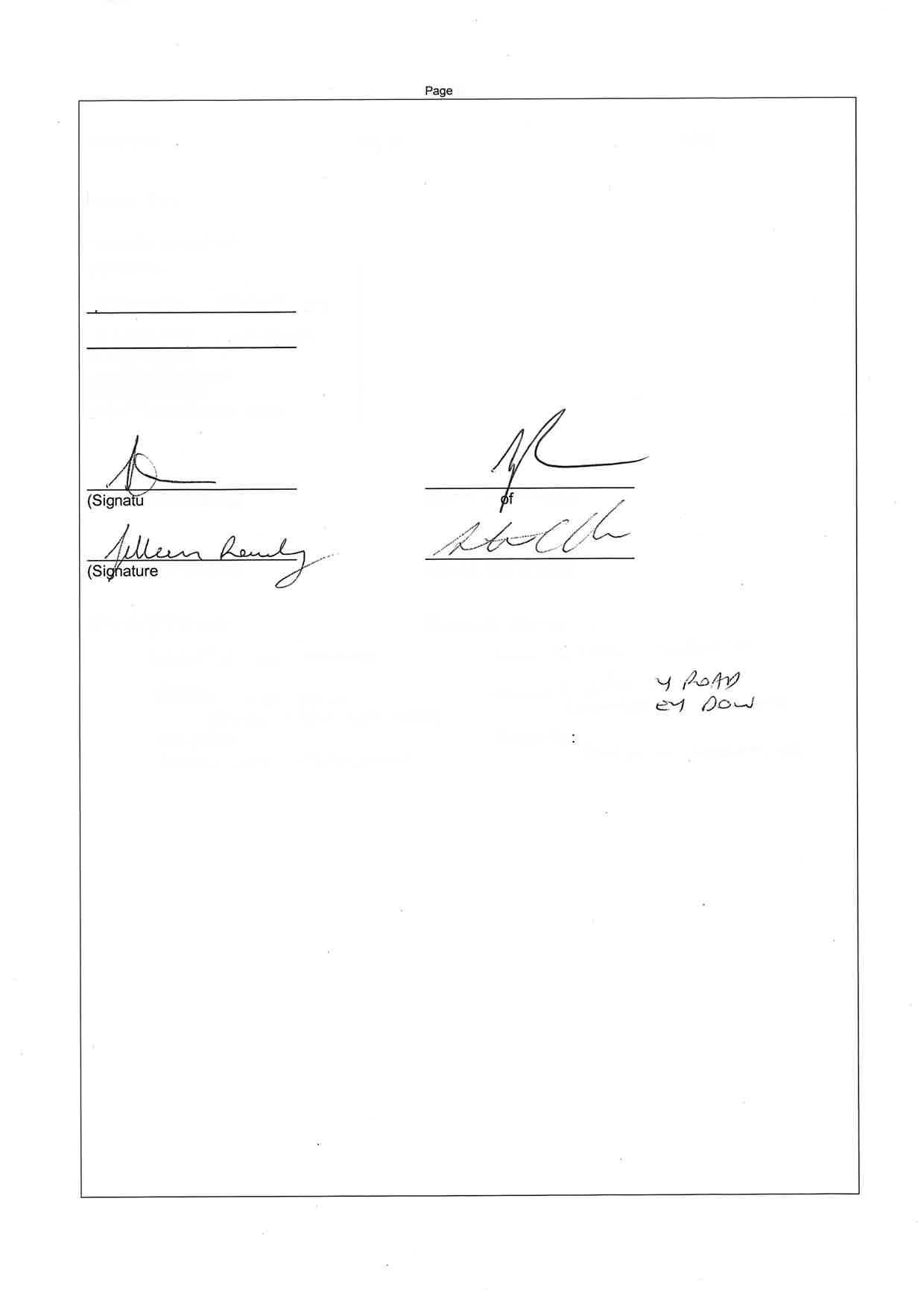
JEREMY CORDINA
General Manager Land – Parcel Property
POA: O127582 Parcel Darch Pty Ltd
Cc: Penny Woodberry | Penny.Woodberry@dwer.wa.gov.au David Jackson | David.Jackson@health.wa.gov.au
Encl: Ongoing monitoring bore plan provided within Site Management Plan
Updated monitoring bore plan to align with retained lots, car parks and road reserves
Letter from Parcel Darch Pty Ltd dated 17th February 2023

T +61 8 9200 4000 info@parcelproperty.com.au
301 Vincent Street, Leederville WA 6007 PO Box 175, Leederville WA 6903
Friday, 17 February 2023
Andrew Miller
Senior Manager | Contaminated Sites
Prime House, 8 Davidson Terrace, Joondalup WA 6027
Dear Andrew,
Thank you for the letter to DWER’s contaminated sites auditor Servensa in relation to Lot 2 Driver Road, Darch dated 17 February 2023 enclosed to this letter.
Within this letter, DWER have requested additional information and confirmation of the developer's commitment to the site following the issue of title. Whilst Servensa will respond to the request for additional information, Parcel Darch Pty Ltd (the Developer) would like to provide the following commitment to DWER and our customers beyond the issue of title for stages currently complete.
Lot 2, 2 Driver Road Development is a 321 lot development of which the first 70 lots are complete. The forecast development timeframe for the balance of the development is 5 years and Parcel Darch Pty Ltd commits to the ongoing monitoring of the completed lots to ensure mitigation measures are performing as intended. The first stage of the development was completed in April 2022 and since this time, post-development monitoring has demonstrated the effectiveness of the mitigation measures.
Parcel Darch Pty Ltd also commits to additional remediation measures should post-development monitoring demonstrate an unacceptable risk to human health on or off-site with the intent of ensuring that buildings within and adjacent to the development are suitable for occupation.
Based on the exhaustive information and validation provided over the past 18 months Parcel Darch Pty Ltd is hopeful that this letter along with the information requested in your letter, to be provided by Servensa will allow DWER to release the required clearances for the site.
If you have any concerns or questions with the information outlined above do not hesitate to contact the undersign on 0437 399 994.
Yours sincerely

JEREMY CORDINA
General Manager Land – Parcel Property
POA: O127582 Parcel Darch Pty Ltd
Cc: Penny Woodberry | penny.woodberry@dwer.wa.gov.au

Our ref: DMO2765, DEC7644/5
Enquiries: Penny Woodberry, Ph 6364 7197
Email: penny.woodberry@dwer.wa.gov.au
Vanessa Bryant Contaminated Sites Auditor Senversa
Email: vanessa.bryant@senversa.com.au
Dear Vanessa
Thank you for submitting the report ‘Mandatory Auditor’s Report 26 Driver Road, Darch, Western Australia’ (Senversa, 16 December 2022) (the MAR) and supporting consultants’ reports to the Department of Water and Environmental Regulation (the department). The MAR and reports were received on 19 December 2022. The addendum to the MAR providing supplementary information was received on 18 January 2023.
It is understood that the MAR and addendum were prepared to satisfy Condition 1 of the Western Australian Planning Commission (WAPC) subdivision approval no. 159221 set for Lot 2 Driver Road, Darch on 6 April 2021. The MAR and addendum follow the submission of previous milestone MARs in June 2021, April 2022 and June 2022.
Following a preliminary review of the MAR, the department and the Department of Health (DoH) agreed that further review of the GasSim modelling supporting the landfill gas risk assessment was warranted. This is because of the complexity and sensitivity of the proposed development, and the significant reliance of the risk assessment on this modelling work. As such, the department requested additional details of the experience of the auditor’s supporting expert and the level of review of the GasSim model carried out by the supporting expert. The requested details were provided by the auditor as part of the addendum to the MAR.
In addition, internal advice was sought from the department’s Industry Regulation, Waste Industries branch (Industry Regulation) with experience in the use and review of GasSim modelling in landfill gas risk assessment. The response to the internal advice request indicated that GasSim is broadly used, and is the most common model for applications assessed by Industry Regulation for existing and proposed landfill cells. The model is commonly referenced in extra jurisdictional landfill guidelines and standards. In addition, Industry Regulation indicated that the inputs applied in the model are in accordance with the GasSim requirements.

Industry Regulation highlighted the following aspects which have the potential to influence the accuracy and appropriateness of the outputs and resultant measures:
• Material characterisation:
The Landfill Gas Generation Assessment1 states that deposited uncontrolled materials are representative of a relatively inert landfill that is not significantly biochemically active. Industry Regulation notes that the Geotechnical Reports2,3 used to develop inputs into GasSim do not provide detailed and comprehensive characterisation of the waste types within the uncontrolled fill areas. Given the sensitivity of the proposed land use, a Detailed Geological Assessment for the full extent of the historical waste body would provide a higher level of certainty for the model input values and estimates.
The level of conservativeness and relevant rationale built into the inputs and resulting mitigation methods is noted, however, Industry Regulation is unable to provide specific advice on whether this conservativeness is sufficient to account for the uncertainties in the material properties of the waste body.
• Settlement / stability:
The Geotechnical Reports characterise the lots as ‘locally loose, deep (up to 25m) uncontrolled fill containing putrescible material’. Noting that overall and differential settlement due to the heterogeneity in waste composition and degradation represent a risk to liner integrity in the gas mitigation membrane, the Geotechnical Reports include recommendations for manual compaction of the exposed waste via a vibratory roller prior to placement of remedial layers and the membrane. This recommendation does not appear to have been proposed in the Conceptual Design4 or Technical Specification5 .
Where the auditor queries the expected settlement and associated membrane resilience (in the MAR Appendix A), the quoted values of 0 to 20 millimetres appear to represent the lower end of the suggested range within the geotechnical reports for well compacted fill. The consultant states that the reinforced limestone raft underlying the membrane is designed to mitigate differential settlement and associated strains on the membrane. There does not appear to be robust demonstration of the ability of the limestone raft layer to fulfil this function.
1 Landfill Gas Generation Assessment, Former Landfill Lot 2, 26 Driver Road Darch WA (Core Environmental Projects, 17 November 2022)
2 Geotechnical Assessment – Stage 1 Proposed Mixed-Use Development 26 Driver Road, Darch (Galt Geotechnics, 17 September 2019)
3 Geotechnical Assessment Proposed Mixed-Use Development 26 Driver Road, Darch. (Galt Geotechnics, 21 October 2019)
4 Conceptual Design of Building Gas Protection Measures, Lot 2, 26 Driver Road Darch (Core Environmental Projects, 17 November 2022)
5 Technical Specification for Gas Risk Mitigation System, Stage 1 & 2, 26 Driver Road Darch WA (Core Environmental Projects, 23 May 2022)
• Construction Quality Assurance:
The Construction Quality Assurance Plan6 includes only manufacturer’s quality assurance, on-site visual inspection and non-destructive weld tests for installation. This may be sufficient for separation geotextiles but for an HDPE membrane as part of a critical containment landfill cap proposal, Industry Regulation generally require the CQA plan to include on-site post-delivery CQA conformance testing (including destructive tests for materials and welds) with the requirement for submission of a detailed validation report assessing compliance with values and tolerances within the plan, including laboratory results. Sub-grade and interface stability assessments may be required depending on the siting and geometry of the waste body.
The department requests that further discussion is provided for each of the above aspects responding to the points raised by Industry Regulation.
The department recognises that it is likely not possible to remove all uncertainty in the landfill gas risk assessment carried out. Therefore, the department requests confirmation of the proponent’s commitment to implement necessary contingency actions to address potential unacceptable risks to human health post-development on or off-site, and to ensure that residences and buildings within or adjacent to the development are suitable for occupation. This includes the Stage 1A development where the department understands that civil works are now complete.
The department looks forward to the receipt of additional information addressing the above. The MAR, addendum to the MAR and the technical advice received from Industry Regulation has been referred to the DoH for review, who may have additional questions or points for clarification.
In closing, the department reiterates the previous recommendation for communication and data sharing between the different parties progressing development of Lot 1 Furniss Rd and Lot 2 Driver Rd to ensure consistency in approach to risk assessment and remedial planning in the context of the proposed development as a whole. Given the potential for the separate development plans of Lot 1 and Lot 2 to impact the other, alignment between the different parties is likely to ensure the best outcome for future site users and adjacent receptors in relation to effective long-term management of the potential risks to human health associated with ground gas.
If you have any queries in the interim, please contact Manager Contaminated Sites, Penny Woodberry, on 6364 7197
Yours sincerely

Andrew Miller SENIOR MANAGER
CONTAMINATED SITES
17 February 2023
6 Construction Quality Assurance Plan for Gas Risk Mitigation System, Stage 1 & 2, 26 Driver Road Darch (Core Environmental Projects, 23 May 2022)
T +61 8 9200 4000 info@parcelproperty.com.au
301 Vincent Street, Leederville WA 6007 PO Box 175, Leederville WA 6903
Friday, 17 February 2023
Andrew Miller
Senior Manager | Contaminated Sites
Prime House, 8 Davidson Terrace, Joondalup WA 6027
Dear Andrew,
Thank you for the letter to DWER’s contaminated sites auditor Servensa in relation to Lot 2 Driver Road, Darch dated 17 February 2023 enclosed to this letter.
Within this letter, DWER have requested additional information and confirmation of the developer's commitment to the site following the issue of title. Whilst Servensa will respond to the request for additional information, Parcel Darch Pty Ltd (the Developer) would like to provide the following commitment to DWER and our customers beyond the issue of title for stages currently complete.
Lot 2, 2 Driver Road Development is a 321 lot development of which the first 70 lots are complete. The forecast development timeframe for the balance of the development is 5 years and Parcel Darch Pty Ltd commits to the ongoing monitoring of the completed lots to ensure mitigation measures are performing as intended. The first stage of the development was completed in April 2022 and since this time, post-development monitoring has demonstrated the effectiveness of the mitigation measures.
Parcel Darch Pty Ltd also commits to additional remediation measures should post-development monitoring demonstrate an unacceptable risk to human health on or off-site with the intent of ensuring that buildings within and adjacent to the development are suitable for occupation.
Based on the exhaustive information and validation provided over the past 18 months Parcel Darch Pty Ltd is hopeful that this letter along with the information requested in your letter, to be provided by Servensa will allow DWER to release the required clearances for the site.
If you have any concerns or questions with the information outlined above do not hesitate to contact the undersign on 0437 399 994.
Yours sincerely
JEREMY CORDINA
General Manager Land – Parcel Property
POA: O127582 Parcel Darch Pty Ltd
Cc: Penny Woodberry | penny.woodberry@dwer.wa.gov.au
Our ref: DMO2765, DEC7644/5
Enquiries: Penny Woodberry, Ph 6364 7197
Email: penny.woodberry@dwer.wa.gov.au
Vanessa Bryant Contaminated Sites Auditor Senversa
Email: vanessa.bryant@senversa.com.au
Dear Vanessa
Thank you for submitting the report ‘Mandatory Auditor’s Report 26 Driver Road, Darch, Western Australia’ (Senversa, 16 December 2022) (the MAR) and supporting consultants’ reports to the Department of Water and Environmental Regulation (the department). The MAR and reports were received on 19 December 2022. The addendum to the MAR providing supplementary information was received on 18 January 2023.
It is understood that the MAR and addendum were prepared to satisfy Condition 1 of the Western Australian Planning Commission (WAPC) subdivision approval no. 159221 set for Lot 2 Driver Road, Darch on 6 April 2021. The MAR and addendum follow the submission of previous milestone MARs in June 2021, April 2022 and June 2022.
Following a preliminary review of the MAR, the department and the Department of Health (DoH) agreed that further review of the GasSim modelling supporting the landfill gas risk assessment was warranted. This is because of the complexity and sensitivity of the proposed development, and the significant reliance of the risk assessment on this modelling work. As such, the department requested additional details of the experience of the auditor’s supporting expert and the level of review of the GasSim model carried out by the supporting expert. The requested details were provided by the auditor as part of the addendum to the MAR.
In addition, internal advice was sought from the department’s Industry Regulation, Waste Industries branch (Industry Regulation) with experience in the use and review of GasSim modelling in landfill gas risk assessment. The response to the internal advice request indicated that GasSim is broadly used, and is the most common model for applications assessed by Industry Regulation for existing and proposed landfill cells. The model is commonly referenced in extra jurisdictional landfill guidelines and standards. In addition, Industry Regulation indicated that the inputs applied in the model are in accordance with the GasSim requirements.
Industry Regulation highlighted the following aspects which have the potential to influence the accuracy and appropriateness of the outputs and resultant measures:
• Material characterisation:
The Landfill Gas Generation Assessment1 states that deposited uncontrolled materials are representative of a relatively inert landfill that is not significantly biochemically active. Industry Regulation notes that the Geotechnical Reports2,3 used to develop inputs into GasSim do not provide detailed and comprehensive characterisation of the waste types within the uncontrolled fill areas. Given the sensitivity of the proposed land use, a Detailed Geological Assessment for the full extent of the historical waste body would provide a higher level of certainty for the model input values and estimates.
The level of conservativeness and relevant rationale built into the inputs and resulting mitigation methods is noted, however, Industry Regulation is unable to provide specific advice on whether this conservativeness is sufficient to account for the uncertainties in the material properties of the waste body.
• Settlement / stability:
The Geotechnical Reports characterise the lots as ‘locally loose, deep (up to 25m) uncontrolled fill containing putrescible material’. Noting that overall and differential settlement due to the heterogeneity in waste composition and degradation represent a risk to liner integrity in the gas mitigation membrane, the Geotechnical Reports include recommendations for manual compaction of the exposed waste via a vibratory roller prior to placement of remedial layers and the membrane. This recommendation does not appear to have been proposed in the Conceptual Design4 or Technical Specification5 .
Where the auditor queries the expected settlement and associated membrane resilience (in the MAR Appendix A), the quoted values of 0 to 20 millimetres appear to represent the lower end of the suggested range within the geotechnical reports for well compacted fill. The consultant states that the reinforced limestone raft underlying the membrane is designed to mitigate differential settlement and associated strains on the membrane. There does not appear to be robust demonstration of the ability of the limestone raft layer to fulfil this function.
1 Landfill Gas Generation Assessment, Former Landfill Lot 2, 26 Driver Road Darch WA (Core Environmental Projects, 17 November 2022)
2 Geotechnical Assessment – Stage 1 Proposed Mixed-Use Development 26 Driver Road, Darch (Galt Geotechnics, 17 September 2019)
3 Geotechnical Assessment Proposed Mixed-Use Development 26 Driver Road, Darch. (Galt Geotechnics, 21 October 2019)
4 Conceptual Design of Building Gas Protection Measures, Lot 2, 26 Driver Road Darch (Core Environmental Projects, 17 November 2022)
5 Technical Specification for Gas Risk Mitigation System, Stage 1 & 2, 26 Driver Road Darch WA (Core Environmental Projects, 23 May 2022)
• Construction Quality Assurance:
The Construction Quality Assurance Plan6 includes only manufacturer’s quality assurance, on-site visual inspection and non-destructive weld tests for installation. This may be sufficient for separation geotextiles but for an HDPE membrane as part of a critical containment landfill cap proposal, Industry Regulation generally require the CQA plan to include on-site post-delivery CQA conformance testing (including destructive tests for materials and welds) with the requirement for submission of a detailed validation report assessing compliance with values and tolerances within the plan, including laboratory results. Sub-grade and interface stability assessments may be required depending on the siting and geometry of the waste body.
The department requests that further discussion is provided for each of the above aspects responding to the points raised by Industry Regulation.
The department recognises that it is likely not possible to remove all uncertainty in the landfill gas risk assessment carried out. Therefore, the department requests confirmation of the proponent’s commitment to implement necessary contingency actions to address potential unacceptable risks to human health post-development on or off-site, and to ensure that residences and buildings within or adjacent to the development are suitable for occupation. This includes the Stage 1A development where the department understands that civil works are now complete.
The department looks forward to the receipt of additional information addressing the above. The MAR, addendum to the MAR and the technical advice received from Industry Regulation has been referred to the DoH for review, who may have additional questions or points for clarification.
In closing, the department reiterates the previous recommendation for communication and data sharing between the different parties progressing development of Lot 1 Furniss Rd and Lot 2 Driver Rd to ensure consistency in approach to risk assessment and remedial planning in the context of the proposed development as a whole. Given the potential for the separate development plans of Lot 1 and Lot 2 to impact the other, alignment between the different parties is likely to ensure the best outcome for future site users and adjacent receptors in relation to effective long-term management of the potential risks to human health associated with ground gas.
If you have any queries in the interim, please contact Manager Contaminated Sites, Penny Woodberry, on 6364 7197
Yours sincerely
Andrew Miller SENIOR MANAGER
CONTAMINATED SITES
17 February 2023
6 Construction Quality Assurance Plan for Gas Risk Mitigation System, Stage 1 & 2, 26 Driver Road Darch (Core Environmental Projects, 23 May 2022)

Congratulations on your recent purchase!
The Developer has lodged a Restrictive Covenant on each title within Kinmore Green which outlines all of the restrictions contained in this brochure.

This leaflet has been created to help you understand siteworks and building on your block and any future endeavours you might undertake.
Welcome to Kinmore Green, an estate surrounded by everything you need. Life here feels just right.
The site is classified as ‘Remediated for restricted use’ under the Contaminated Sites Act 2003.
The site is COMPLETELY SAFE FOR YOU AND YOUR FAMILY based on extensive remediation done by the developer.
This classification is very common for residential estates and ensures that all health risks appropriately mitigated through certain restrictions on what you can do at your property. Remediated for Restricted use.
More information can be sourced from Parcel, DWER (Department of Water and Environmental Regulation) or the Kinmore Green website, www.kinmoregreen.com.au
This membrane has been engineered to provide a factor of safety many times higher than required to provide piece of mind for residents.

The location of the membrane and passive venting zone is shown on each owner’s lot plan. The passive venting zone can not have habitable structures or sealed surfaces on it.
YOU CANNOT BUILD ON THE PASSIVE VENTING ZONE


YOU MAY NOT DIG DEEPER THAN 2M

The membrane is located more than 2m below each lot. Therefore you can safely excavate up to 2m for a swimming pool or spa (subject to council approval).


YOU CAN NOT INSTALL AN IRRIGATION BORE
Appendix J: Understanding Your Report

This document has been prepared to clarify what is and is not provided in your report. It is intended to inform you of what your realistic expectations of this report should be and how to manage your risks associated with the conditions on site.
Geotechnical engineering and environmental science are less exact than other engineering and scientific disciplines. We include this information to help you understand where our responsibilities begin and end. You should read and understand this information. Please contact us if you do not understand the report or this explanation. We have extensive experience in a wide variety of projects and we can help you to manage your risk.
This report was developed for a unique set of project-specific conditions to meet the needs of the nominated client. It took into account the following:
the project objectives as we understood them and as described in this report; the specific site mentioned in this report; and the current and proposed development at the site.
It should not be used for any purpose other than that indicated in the report. You should not rely on this report if any of the following conditions apply:
the report was not written for you; the report was not written for the site specific to your development; the report was not written for your project (including a development at the correct site but other than that listed in the report); or the report was written before significant changes occurred at the site (such as a development or a change in ground conditions).
You should always inform us of changes in the proposed project (including minor changes) and request an assessment of their impact.
Where we are not informed of developments relevant to your report, we cannot be held responsible or liable for problems that may arise as a consequence.
Where design is to be carried out by others using information provided by us, we recommend that we be involved in the design process by being engaged for consultation with other members of the project team. Furthermore, we recommend that we be able to review work produced by other members of the project team that relies on information provided in our report.

Where data is provided by third parties, it will be identified as such in our reports. We necessarily rely on the completeness and accuracy of data provided by third parties in order to draw conclusions presented in our reports. We are not responsible for omissions, incomplete or inaccurate data associated with third party data, including where we have been requested to provide advice in relation to field investigation data provided by third parties.
Our reports often include logs of intrusive and non-intrusive investigation techniques. These logs are based on our interpretation of field data and laboratory results. The logs should only be read in conjunction with the report they were issued with and should not be re-drawn for inclusion in other documents not prepared by us.
We have prepared this report for use by the client. This report must be regarded as confidential to the client and the client’s professional advisors. We do not accept any responsibility for contents of this document from any party other than the nominated client. We take no responsibility for any damages suffered by a third party because of any decisions or actions they may make based on this report. Any reliance or decisions made by a third party based on this report are the responsibility of the third party and not of us.
The recommendations in this report are based on the ground conditions that existed at the time when the study was undertaken. Changes in ground conditions can occur in numerous ways including anthropogenic events (such as construction or contaminating activities on or adjacent to the site) or natural events (such as floods, groundwater fluctuations or earthquakes). We should be consulted prior to use of this report so that we can comment on its reliability. It is important to note that where ground conditions have changed, additional sampling, testing or analysis may be required to fully assess the changed conditions.
Practical constraints mean that we cannot know every minute detail about the subsurface conditions at a particular site. We use professional judgement to form an opinion about the subsurface conditions at the site. Some variation to our evaluated conditions is likely and significant variation is possible. Accordingly, our report should not be considered as final as it is developed from professional judgement and opinion.
The most effective means of dealing with unanticipated ground conditions is to engage us for construction support. We can only finalise our recommendations by observing actual subsurface conditions encountered during construction. We cannot accept liability for a report’s recommendations if we cannot observe construction.
Unless specifically mentioned otherwise in our report, environmental considerations are not addressed in geotechnical reports Similarly, geotechnical issues are not addressed in environmental reports. The investigation techniques used for geotechnical investigations can differ from those used for environmental investigations. It is the client’s responsibility to satisfy themselves that geotechnical and environmental considerations have been taken into account for the site.
Geotechnical advice presented in a Galt Environmental report has been provided by Galt Geotechnics under a sub-contract agreement. Similarly, environmental advice presented in a Galt Geotechnics report has been provided by Galt Environmental under a sub-contract agreement.
Unless specifically noted otherwise, no parties shall draw any inferences about the applicability of the Western Australian state government landfill levy from the contents of this document.
O:\Administration\Standard Forms and Documents\GEPL Forms\PMP29-Rev4 Understanding your Report Env Logo.docx