upfront soundcheck
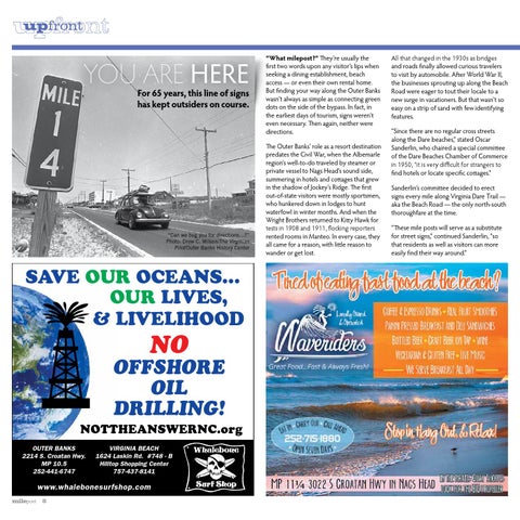
YOU ARE HERE
For 65 years, this line of signs has kept outsiders on course.
getactive
startingpoint roadmap gokite milepost
“Can we bug you for directions…?” Photo: Drew C. Wilson/The Virginian Pilot/Outer Banks History Center
SAVE OUR OCEANS… graphiccontent gosurf outthere
OUR LIVES, & LIVELIhOOd
NO
gohunt rearview
OFFSHORE OIL DRILLING!
NOTThEANSWERNC.org OUTER BANKS 2214 S. Croatan Hwy. MP 10.5 252-441-6747
VIRGINIA BEACH 1624 Laskin Rd. #748 - B Hilltop Shopping Center 757-437-8141
www.whalebonesurfshop.com milepost
8
“What milepost?” They’re usually the first two words upon any visitor’s lips when seeking a dining establishment, beach access — or even their own rental home. But finding your way along the Outer Banks wasn’t always as simple as connecting green dots on the side of the bypass. In fact, in the earliest days of tourism, signs weren’t even necessary. Then again, neither were directions. The Outer Banks’ role as a resort destination predates the Civil War, when the Albemarle region’s well-to-do traveled by steamer or private vessel to Nags Head’s sound side, summering in hotels and cottages that grew in the shadow of Jockey’s Ridge. The first out-of-state visitors were mostly sportsmen, who hunkered down in lodges to hunt waterfowl in winter months. And when the Wright Brothers returned to Kitty Hawk for tests in 1908 and 1911, flocking reporters rented rooms in Manteo. In every case, they all came for a reason, with little reason to wander or get lost.
All that changed in the 1930s as bridges and roads finally allowed curious travelers to visit by automobile. After World War II, the businesses sprouting up along the Beach Road were eager to tout their locale to a new surge in vacationers. But that wasn’t so easy on a strip of sand with few identifying features. “Since there are no regular cross streets along the Dare beaches,” stated Oscar Sanderlin, who chaired a special committee of the Dare Beaches Chamber of Commerce in 1950, “it is very difficult for strangers to find hotels or locate specific cottages.” Sanderlin’s committee decided to erect signs every mile along Virginia Dare Trail — aka the Beach Road — the only north-south thoroughfare at the time. “These mile posts will serve as a substitute for street signs,” continued Sanderlin, “so that residents as well as visitors can more easily find their way around.”