4 minute read
Nature Escape


Nature Escapes
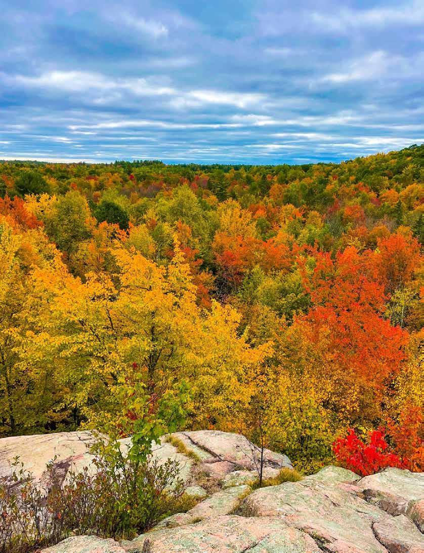
Quartz Hill
Advertisement
Pack up the family and travel to the northernmost region of Oconto County for a truly remarkable fall adventure. The Quartz Hill Trail offers one of the prettiest views of the brilliant fall colors from atop a quartz rock outcrop. Hike through the Chequamegon-Nicolet National Forest to witness the dazzling colors of the hardwood forest and the glassy luster of quartz crystal. Quartz Hill Trail is located on Highway 32, about 4 miles north of Townsend on the border of Oconto and Forest counties. The trail is divided into two separate sections - one to the east and one to the west of Highway 32. The east section of Quartz Hill Trail leads to the summit of McCaslin Mountain. The scenic overlook provides a panoramic view of the surrounding hills and forest. Rated moderate to difficult, the trail presents a modest challenge to hikers due to its steep ascents and rocky, uneven terrain. However, the trail generally is dry, with boardwalks spanning the wettest areas. Interpretive signs along the trail draw attention to the area’s unique history and identity. For example, upon reaching the quartz crystal deposit, hikers can learn why the early Native Americans visited Quartz Hill to collect quartz. The Quartz Hill Trail is worth the drive to northern Oconto County for a breathtaking view of the fall colors. Take some photos – but please don’t take the quartz. Rockhounding is prohibited in order to preserve the quartz for others to enjoy. Happy hiking!
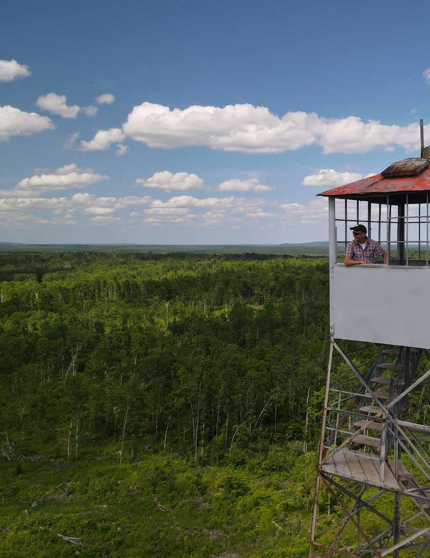
Mountain Fire Lookout Tower
See Northern Oconto County ablaze with fall color from 100 feet in the air. Experience a bird’s eye view of the Northwoods’ natural beauty at the Mountain Fire Lookout Tower. The Mountain Fire Lookout Tower delivers a spectacular panorama of the east side of the Chequamegon-Nicolet National Forest. To reach the 7- by 7-foot lookout perch, all you need to do is climb 132 steps. The effort is well worth it! The Mountain Fire Lookout Tower rewards climbers with breathtakingly vibrant shades of red, orange, and yellow. The steel tower was built in 1935 by the U.S. Forest Service and Civilian Conservation Corps. Just the 41st lookout tower registered in the U.S., the tower is listed on the National Historic Lookout Register and the National Register of Historic Places. With the help of key partnerships and community donations, the Lakewood-Laona Ranger District completely restored the tower in 2015 and 2016. For the best view, visit the Mountain Fire Lookout Tower in late September and early October - typically the time of year when fall foliage is at its peak in Oconto County. The Mountain Fire Lookout Tower is located 3 miles north of Mountain and is open from 8 a.m. until sunset until Nov. 1. Visiting the site is free, but donations are appreciated.
The natural area itself is quite aesthetic with numerous rock outcrops affording scenic views and having one of the few waterfalls on the Nicolet. Hagar Mountain is owned by the USDA Forest Service and was designated a State Natural Area in 1996. Directions: From the intersection of State Highway 32 and County Highway W in Mountain, go east on W 3 miles to the junction with FR 2630 (Bear Paw Rd). Continue on W 0.5 mile to a cabin at Fire #13124. Park along W. To reach Hagar Mountain, go north on a foot trail that runs along the property line from the east side of the cabin. Please do not trespass on private land.
Cathedral Pines
Cathedral Pines is a 40-acre grove of white pine, hemlock and red pine that escaped cutting by lumberjacks in the 1900s. Located in the ChequamegonNicolet National Forest’s Lakewood-Laona Ranger District, this dynamic and exceptionally scenic old-growth forest is one of the few remaining stands of towering pine and hemlock in Wisconsin. Directions: Take State Highway 32 on the north end of the Town of Lakewood, turn southwest onto Archibald Lake Road (Forest Road 2121). Drive 1.4 miles on FR 2121, then look for the “Watchable Wildlife” sign and turn right (northwest) onto Cathedral Drive (FR 3299). Drive 0.4 mile on this gravel road to the parking lot. After your visit, continue driving northwest on Cathedral Drive, then take a right onto paved Presbyterian Road (FR 3304) and you’ll quickly come to County Highway T near Townsend.
A hiking trail was developed in the Town of Brazeau to reach the county's highest point called Butler Rock. This two mile sand trek is not for the fainthearted, but the views are spectacular, especially during the Fall colors. The hike to Butler Rock is moderate and totally worth the short but steep incline during the last 0.2 miles to the top. The lookout at the top of Butler Rock of the surrounding Chequamegon-Nicolet National Forest is a must-see view. Directions: In Mountain, turn right onto Old 64 Road/Old Hwy 64, sharp right onto Butler Rock Road and turn left onto Butler Rock Lookout Lane.


