6 minute read
SLO’s new open space


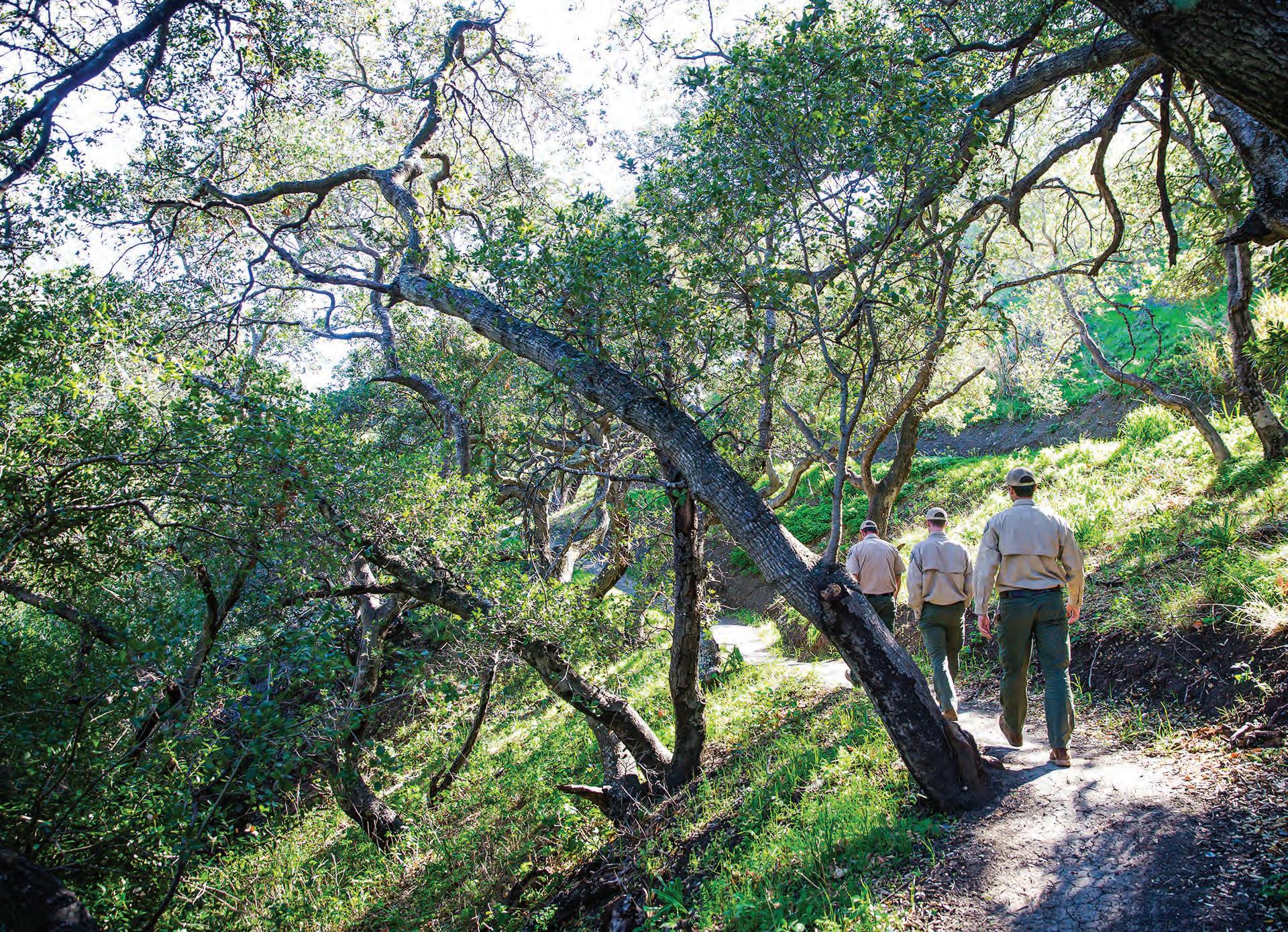
SLO city rangers Doug Carscaden, Niels Grether, and Basile Inman hike the city’s newest trail they helped create in the Miossi Open Space.
San Luis Obispo’s new open space unlocks the city’s greenbelt
STORY BY PETER JOHNSON PHOTOS BY JAYSON MELLOM
The rumble of Highway 101 fades as I walk up and over the eastern hills of San Luis Obispo. It’s quiet but for the occasional groan of a cow or screech of a hawk. Through shaded oak groves and wildflower-dotted grassland, I hike alongside four others who have helped turn this longtime private ranch near the Cuesta Grade into the city of SLO’s newest “greenbelt” property, the Miossi Open Space.
“It’s been a soft opening so far,” says city Sustainability and Natural Resources Director Bob Hill, who’s flanked by three park rangers in uniform. “Since we finished the trail and opened the gates, it’s been about a year, I’d say.”
SLO purchased these 266 acres in late 2018 from the Miossis—a prominent local ranching family dating back to the early 20th century. This property is just a sliver of their ranch, which stretches westward to Cuesta Canyon Park near city limits. The city is currently working with the Ranger Niels Grether leads hikers through an underground culvert that crosses the railroad tracks. Miossis on a conservation easement for the remainder of the ranch. “I’ve known Gabriel Miossi for I’d say 15 years,” Hill says. “When I came over to the city almost 10 years ago, he sort of walked into City Hall cold. We were originally talking about a conservation easement for the whole ranch. But I could see these trail connection opportunities from Poly Canyon to Old Stagecoach Road, and to West Cuesta Ridge.” It’s those trail connections that have outdoor enthusiasts most excited about the new acquisition. In just a few months, the city will start work on a trail that will link the Miossi Open Space to Poly Canyon—which will unlock miles upon miles of newly connected trails throughout the eastern hills.
“In November, we secured a trail agreement with Cal Poly,” Hill explains. “That will dramatically improve the trail circulation network, not only for here but getting up to West Cuesta Ridge, Stenner Springs, and other locations as well.” TRAILS continued page 34
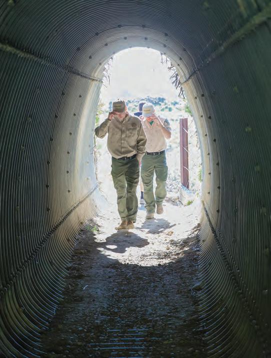
Ranger Niels Grether leads hikers through an underground culvert that crosses the railroad tracks.
But that’s still some months off. Even as a standalone open space, Miossi and its roughly 3 miles of new trails pack quite a punch. Accessible by Highway 101, on Old Stagecoach Road, the trailhead provides both car and bike parking, a kiosk with a map to guide you, and helpful accessories like bike bells and dog leashes.
Because COVID-19 nixed the city’s plans for a big ribbon-cutting ceremony, the trail is still relatively undiscovered and feels peaceful and secluded. Conditions are perfect on this Feb. 1 afternoon. After starting in a lush oak grove, the trail links up with a steep old ranch road, which climbs up and over a hill, revealing sweeping southwest views of the Cuesta Ridge, Reservoir Canyon, and Poly Canyon. The trail eventually runs into the Union Pacific Railroad tracks, which are passable thanks to an interesting underground culvert. “When they built the train tracks, the Miossis negotiated this undercrossing so they could move cattle back and forth,” Hill explains, as we cross under the tracks and continue onto the new Panorama Trail. Carved into the hillside, the Panorama Trail meanders up a gentle grade and provides a cascade of amazing views of everything to its west. Along the way, we see an occasional heritage oak and a constant stream of flora, including poppies and lupine.
“There’s five different types of lupine on this property,” Hill notes. While crafting the Miossi Open Space’s conservation plan, biologists found seven rare plant species and seven sensitive wildlife species, including white-tailed kites, peregrine falcons, and California coast steelhead, as well as Santa Lucia manzanita, clubhaired mariposa lily, and smallleaved lomatium. “This is really about habitat and natural resources protection first,” Hill emphasizes.
One of the park rangers who joins our hike, Niels Grether, shares that the conservation plan is the guiding document for determining the path of a trail. Grether is a trail expert, having helped design and build several popular city trails, like the new “M” trail on Cerro San Luis Mountain.
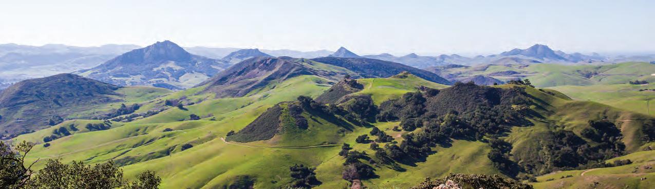
“It’s funny, there are so many little factors that go into the layout of the trails,” Grether says. “We start from resource preservation, looking at a map to see which areas need to be protected. The science of trail building is also making sure your grade is not too steep. Managing the water is a big part of that. And ideally, you have the trail kind of take you on an interesting journey.” After roughly a mile, Miossi’s Panorama Trail levels off at a vista point that sits at about 1,300 feet. Here lies the hike’s

City Ranger Doug Carscaden gazes out at the incredible views that accompany the Miossi Open Space trail.
greatest reward: an unobstructed panorama of the valley below and the towering Nine Sisters morros all the way to Morro Rock in the Pacific Ocean.
Basile Inman, another ranger, is the man behind a second impressive attraction at this lookout—a long, curved horizontal sign illustrating the landscape behind it, with each peak labeled and a history about the morros included.
“When we were out here scouting the trail … this is just such a sweet spot,” Inman says. “We wanted to educate people on the history of the morros as well as the Chumash culture associated with them. We actually took measurements, photographs, and used Google Maps to get the scale of everything. Building the frame up, that was a whole learning experience. It was really challenging.”
From here, hikers and bikers can continue on to complete the Roller Coaster, a 0.7-mile loop that climbs another 230 feet and circles back to the lookout point. But we decide to turn around and walk back via Panorama, taking a quick detour at La Cuesta Ranch Road, near the railroad undercrossing, for a sneak peek at the soon-to-be trail connection to Poly Canyon.
“We were out here last week,” Grether says, pointing to various red flags pinned on the downsloping hillside. “We’ve got the rough alignment. We just gotta come back and do the fine flag.”
Before turning back, Ranger Supervisor Doug Carscaden takes a moment to express his appreciation for the resources that the city provides his department in its commitment to open space. The city now has 7,000-plus acres of open space it manages.
“They’ve always funded open space acquisition,” Carscaden says, “and over the last couple of years, we’ve gotten a ton of money. We’ve got specialized tools to do basically every single thing we need to do now.”


