5
2
70
45
210
70
33
45
23
Yellow Lake
Bo ne Lake
Frederic
43
Siren
Burnett County
State of Minnesota
48
35
Luck
Ba lsa m Lake
Balsam Lake
10
39
43
Devils Lake
Webster
Cla m Lake
194
3
2
77
ui
53
9
535
Superior
41
2
Lake Na ncy
2
35
M inon g Flo w age
Saint Cro ix Flo w age
Ba rdon Lake
Minong
8
Poplar
61
Lake Superior
7
Lake Nebag am on
Lake Nebagamon
2
39
39 63
Rice Lake
48
33
94
Prairie Lake
10
70
New Auburn
27
29
40
12
13
M iddle Ea u Cla ire Lake Low er Ea u Cla ire Lake
27
2
Upp er Ea u Cla ire Lake
8 Nelso n Lake
31
Grindston e Lake
7
Bruce
27
31
Lake Ow en
70
Spider Lake
2
8 Lost Land Lake
77
Ch ippewa Lake
10
27
2
31
Winter
M oose Lake
15
63
Mason
Na mekag on Lake
21 Teal Lake
70
27
12
1
25
25
Bayfield
a Fl
21
Ingram
Red Cliff
8
2
o u th
21 13
la m
be
au
R
70
Bu tternu t Lake
Butternut
kF
10
For
Kennan
12
169
Apostle Islands National Lakeshore
Bad River
B ad R iv e r
Mellen
77
25
Hawkins
25
e
Ashland County
25
8
13
Ashland
13
112
Washburn
118
4
90
5
Glen Flora
Rusk County
Tony
Dairyland Reservo ir
Ladysmith
Conrath
194
Sheldon
18
Otter Lake
27
Stanley
50
21
111
Catawba
77
122
Squ
8
a
2
Phillips
8 13
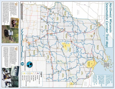
•Please note that the corridors depicted on these maps only identify major trails and the routes connecting them.
70
Lac du Flambeau
8
28
State of Michigan
182
Big Pin e Lake
Pike Lake
Ro und Lake
10
12
19
97
2
•Please contact the individual counties (see contact information on reverse side ) to request a detailed trail map.
17
51
Trude Lake
102
•Some counties may have digital maps available for use with a mobile device.
Hurley Gile Flo w age
Turtle Fla mb eau Flo w age
19
19
Montreal
182
12
86
Prentice
23
21
Public Land
Tribal Land
Large River/Lake/Flowage
153
State Boundary
County Boundary
City/Village
State Highway
US Highway
Interstate
Snowmobile Corridor
Legend
16
Price County
10
Iron County
16
13
Park Falls
64
98
www.northwestwisconsin.com 40
29
Boyd
Chippewa County
Cornell
Holcom be Flo w age
Radisson
40
Cadott
27
Sawyer County
Tiger C at Flo w age
1
Bayfield County
wa
Exeland
Couderay
Lac Courte Oreilles
31
p pe
178
27
Lake Wisso ta
30
Chippewa Falls
64
40
8
31
48
W hitefish Lake
Lac C ourte Oreilles
Hayward
31
12
14
Bloomer 53 124
Long Lake
Weyerhaeuser
Lake Ch etac
Sissa baga ma Lake
18
7
20
Eau Claire
Red C eda r Lake
Birchwood
10
Lake Ch etek
33
33
Chetek
Cameron
Rice Lake
Washburn County
Upp er S aint Cro ix Lake
77
35
35
Spoo ner Lake
253
Shell Lake
Bear Lake
Haugen
37
37 Dallas
Barron
18
53
Solon Springs
41
Spooner
39 Shell Lake
25
Cumberland
10
Barron County
Almena
Beaver Dam Lake
M cK en zie Lake
Douglas County
35
Superior
43
Webb Lake
35
8 Birch Islan d Lake
70
12 Turtle Lake
18
Sand Lake
105 Oliver
41 St. Croix
8
Big Tribe Sand Lake
12
10
St. Croix Tribe Big Ro und Lake
Amery
39
Clayton
Polk County
45
Northwest Wisconsin Snowmobile Corridor Trail Map 73
Ph anto m Lake
45 Grantsburg
87
Deer Lake
Milltown
Centuria
St. Croix Falls
Dresser Wa pog asset Lake
46 Prairie Farm
5
er iv
27 289
48
Osceola
43 65 Clear Lake
94
0
Miles
ith over 4,500 miles of snowmobile trails maintained by local snowmobile clubs, Northwest Wisconsin is home to some of the best riding in the Midwest. Well maintained trails wind their way through rolling hills and scenic forests, passing by lakes, rivers and ponds. Along the trail system riders will find friendly business owners ready to cater to their lodging, food & beverage, fuel and other needs.
W
S
For help planning your snowmobile trip to Northwest Wisconsin, visit www.northwestwisconsin.com where you will find links to up-to-date trail reports, maps, lodging, dining, rental information, and more or to request additional copies of this Northwest Wisconsin ATV/UTV & Snowmobile Corridor Trail Map.
C r eek w
er R iv au b
m
35
123
95
95
Cedar Lake
7272
r R i ve
97
96
94
10
All data, information, and maps are provided "as is", without warranty or any representation of accuracy, timeliness, or completeness. The burden for determining accuracy, completeness, timeliness, merchantability, and fitness for, or the appropriateness for use, rests solely on the requester. The NWRPC makes no warranties, expressed or implied, as to the use of the information obtained here. There are no implied warranties of merchantability or fitness for a particular purpose. The requestor acknowledges and accepts all limitations, including the fact that data, information, and maps are dynamic, and in a constant state of maintenance, correction, and update.
W ith over 1,000 miles of ATV trails maintained by local ATV clubs, Northwest Wisconsin boasts some of the most enjoyable riding in the Midwest. Along the trail system riders will find easy access to businesses ready to cater to their lodging, food & beverage, fuel and other needs.
Many of the counties allow UTVs and off-road motorcycles on some trails during certain times of the year. Visit www.northwestwisconsin.com to find more information on all of the incredible trail systems in Northwest Wisconsin, links to maps, trail conditions, equipment rental information, lodging & dining and more or to request additional copies of this Northwest Wisconsin ATV/UTV & Snowmobile Corridor Trail Map.
i Ch
a r Rive r C ed
R ed
s River t Lo S a in
47
107