ZONE DEFENSE
What zones measure Since the early 20th century, plant breeders have used cold hardiness rating to indicate whether a plant will survive winter in a particular area. The United States is divided into 13 zones, from the coldest (zone 1a, -60 degrees Fahrenheit) to the warmest (zone 13b, 65 degrees) based on the lowest average low temperature in a year. For the most recent map, Oregon State University scientists collected measurements over 30 years from more than 13,000 weather stations, nearly doubling the number of data points from previous maps. The great detail in the map is one reason that much of the Twin Cities moved to zone 5, while pockets of zone 4 can be found scattered throughout. For example, Shoreview, a northern Twin Cities suburb, is zone 5 except for an area near Highway 10. Similar pockets of cold or warmth can be found in many areas, both in urban and rural areas. Temperatures are getting warmer overall, especially low temperatures, but the new zone map’s detail also captures the heat island effects of parking lots, roofs and other urban features. Other than Alaska, only Minnesota, North Dakota, Montana and mountainous areas of Maine and Wyoming now have zone 3 growing areas. In contrast, in the zone map from 1990, half of Minnesota was rated zone 3 with a sliver of zone 2 on the northern border with Manitoba. While cold hardiness zones are useful, they measure only one climate factor in plant survival. Additional factors, such as day length, snow cover, humidity, wind, drought, soil moisture and even how long a cold snap lasts can determine whether a plant thrives or dies. Canada has its own cold hardiness map with a different numbering system. Europe also has its own cold hardiness map, with 11 zones from the frigid Arctic to the temperate Mediterranean. The American Horticultural Society has ratings for heat zones as well, which are based on how many days of the year have high temperatures above 86 degrees.
36
SPRING 2025 / NORTHERNGARDENER.ORG
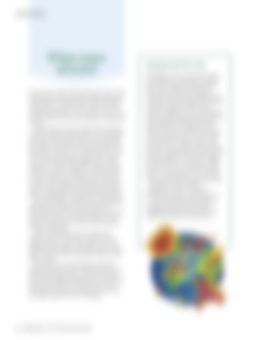
THE BIGGER PICTURE The Köppen climate classification system was developed a century ago and still has value today. It divides climates into five basic types: tropical, arid, temperate, continental and polar, with subdivisions in each type. The Upper Midwest has a humid continental climate with four distinct seasons including very cold, snowy winters and hot, humid summers with precipitation evenly distributed throughout the year. Similar climates can be found in eastern Europe, Russia and northern China, which is why many plants native to those areas grow well here. Consider peonies, which are native to large swaths of eastern Europe and north Asia but flourish in the plains of the Upper Midwest. Cotoneaster, a hedge plant that thrives in our northern climate, is native to vast areas of Europe and Asia, but not to North America. It’s our distinct climate that helps those plants thrive here. Ecoregions, another climate classification system, are useful for choosing native plants. Developed by the U.S. Environmental Protection Agency, ecoregions define areas with similar topography, soil and climate that tend to support similar plant and animal life.