
5 minute read
Leading the transition to low carbon

by NIWA_NZ

SUPPORTING A JUST TRANSITION
Advertisement
• Tools and advice to support climate change adaptation and mitigation • Measure and understand greenhouse gas sources and pathways • Communicate the science of climate change
EXPLOITING OUR RENEWABLE ENERGY SOURCES
• Customised data and tools for optimal electricity generation • Minimise potential environmental impacts from renewable energy • Small-scale, multi-source power for self-sufficiency and resilience
MITIGATING GREENHOUSE GAS EMISSIONS
• Determine local to global sources and sinks of greenhouse gases • High-precision, long-running measurement series to understand the drivers of climate change • Assess the effectiveness of measures aimed at reducing greenhouse gas emissions

NIWA carried out extensive survey work at Lake Onslow to provide an initial environmental reference point before any development takes place. [Andrew Willsman]

Lake Onslow as water storage for hydroelectricity
Research is underway to investigate the use of pumped water storage to support hydroelectricity generation during dry years, when there is insufficient water storage in existing hydropower lakes. The large and diverse NIWA team working on the project completed an environmental baseline study which included a bathymetry survey, monitoring the effects of weather and climate on the lake, hydrodynamic modelling, a fish food-web study, examining the impacts of pumped hydroelectric energy storage on lake ecology and assessing macrophytes and potential biosecurity issues. They also investigated potential greenhouse gas emissions. Our science has informed the first phase of MBIE’s feasibility study. In addition to the baseline study at Lake Onslow, we led a nationwide GIS scan of potential sites for a pumped storage system and we also assessed the variability and correlation between the potential for hydro, wind and solar energy under future climate scenarios.
What role do our estuaries play in reducing greenhouse gas emissions?
NIWA has developed automated habitat mapping techniques which are being applied to mangrove forests and seagrass meadows around New Zealand to help determine the role our estuaries can play in achieving greenhouse gas emission reduction targets. There is increasing scientific and policy interest in this globally, and a key step involves accurately quantifying the distribution of estuarine vegetation to assess its role in carbon sequestration – so-called blue carbon habitats. Researchers are exploring the use of satellites for remote hyperspectral imaging. This technology takes pictures at hundreds of closely spaced wavelengths. Describing each point of an image (pixel) by hundreds of numbers, rather than just the three of our red/green/blue vision, gives a considerable gain in information. It can identify the signature of different habitats, including plant types, and its application in estuaries is being further explored to assess health, productivity and carbon storage provided by these habitats. It could also be used to identify multiple plant species in saltmarshes, which are threatened habitats in New Zealand. Regional councils and the Department of Conservation will be able to use the mapping tool to determine the location and quantity of mangrove and seagrass habitats for long-term monitoring. These maps will be used in an MBIE-funded Smart Idea to estimate national blue carbon inventories. Refinement of the national inventory is crucial to support mitigation efforts as the country transitions to a low carbon economy.
Aerial remote sensing provides a costeffective approach for mapping extensive seagrass meadows, like this site near Tauranga Harbour, to help assess blue carbon – the carbon stored in coastal and oceanic ecosystems. [Carolyn Lundquist]

Measuring the Raukūmara forest restoration
The mauri of the Raukūmara Range on the East Cape – ancestral ngāhere of Ngāti Porou and Te Whānau-ā-Apanui – has been damaged through decades of destruction by deer, goats, possums and human land-use changes. NIWA’s CarbonWatch NZ researchers have teamed up with the Raukūmara Pae Maunga restoration project, which includes the two iwi and the Department of Conservation Te Papa Atawhai – an ambitious project to regenerate the pestravaged Raukūmara Range on the East Cape. The collaboration includes knowledge sharing between partners, including working together to understand the atmospheric signals from the forest. CarbonWatch NZ is investigating carbon emissions and uptake across cities, forests and grasslands. The programme will monitor the uptake of CO2 across the Raukūmara ngāhere, and, as pest control ramps up and the forest regenerates, the researchers hope that this will result in increased CO2 uptake. Meteorological stations have been installed on either side of the range and CO2 monitoring is being established.

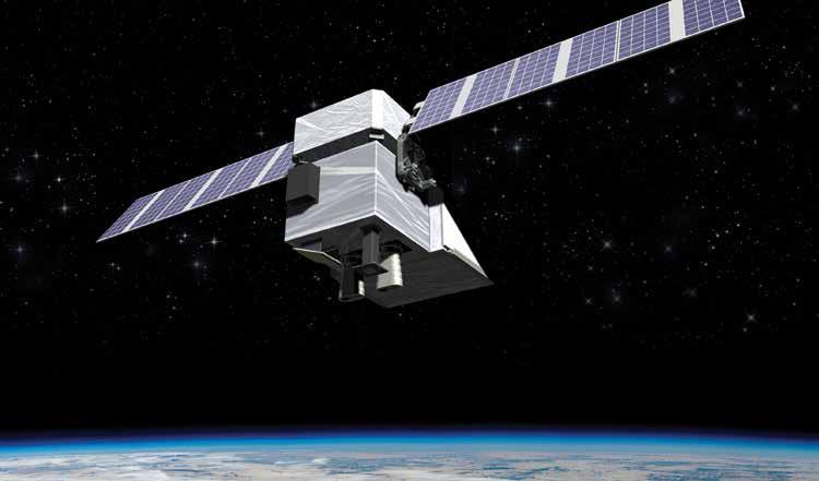
MethaneSAT, due to be launched in the first half of 2023, will measure agricultural emissions from 200 targets globally. [MethaneSAT LLC]
Tracking methane emissions
The MethaneSAT research team in New Zealand has identified the best agricultural targets across the globe for satellite observation of methane emissions. While the team are organising groundbased measurements, they are also preparing for the satellite’s launch next year. NIWA’s Dr Sara Mikaloff-Fletcher is leading the MethaneSAT agricultural research programme, part of an international space mission helping to tackle climate change. MethaneSAT‘s core purpose globally is to gather data to inform a reduction in methane emissions from oil and gas sources; research in New Zealand, funded by MBIE, is focused on reducing global emissions from agriculture. The New Zealand team has identified about 200 agricultural targets, each around 200 by 200 kilometres in size, across every continent except Antarctica. These targets, which are focused on ruminant farming and rice growing, were identified from data about methane emissions, land use and weather patterns. Once the satellite is launched, it will scan about 20 to 30 targets each day – a mix of agricultural targets, oil and gas production sites and potentially even targets such as landfills and mining sites. By verifying emission estimates based on industry statistics, the research will identify where emissions can be cut most effectively.
In August 2022, the CarbonWatch NZ team hosted eight rāngatahi from five kura, teachers of the high school students and other members of the Raukūmara Pae Maunga restoration project at a wānanga in Wellington. The four-day trip included hands-on activities at NIWA’s Wellington site, Baring Head and nearby Catchpool Valley. The wānanga was part of the ongoing partnership which will also include regular visits to the Raukūmara region by the CarbonWatch NZ team. [Mia Blyth]


