New Zealand Mountain Bike Trail Design & Construction Guidelines


Mountain Biking has quickly become a mainstream sport, with a broad range of bike trails being developed all around New Zealand.
Projects are now being driven by land managers such as DOC, Iwi, local and regional councils and also private land owners, adding a more structured and professional approach to complement the well established volunteer based, club driven structure.
Often the project manager or engineer managing the project has no background in the sport, and the volunteer driver may be light on the steps needed to produce a fit for purpose product.
This new guideline is intended to help all parties develop and clarify their understanding of the creative elements that go into delivering a fun trail experience at each of the six different grades of difficulty.
This guideline gives a detailed and defined specification for new trails at each grade, and also provides a template for the maintenance and auditing of existing trails. Any organisation involved with developing, building, maintaining or auditing a trail is encouraged to use these guidelines - with the over riding goal for NZ being a level of consistency and continuity around trail grading to ensure a fantastic user experience
 Photography by
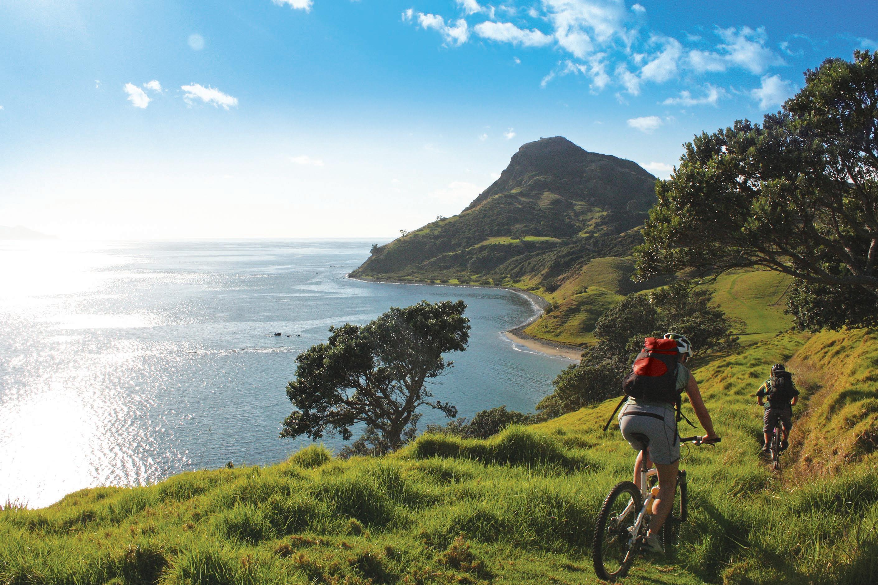
Suitable for all ages and most fitness levels. The trail feels safe to ride and is ideal as a first ride for non-cyclists, and those wanting an easy gradient or experience. They shall be well formed, flat, wide and smooth. The trail allows for cyclists to ride two abreast most of the time, and provides a social component to the ride. Cyclists will be able to ride the total distance of the trail without dismounting for obstacles.
Riders develop balance and gear choice skills. Trail shall be well formed, smooth and with some gentle climbs, is predictable with no surprises and is suitable for beginner riders Trail has a social aspect with riders being able to ride side by side at times but the majority of the trail provides for a single rider. Suitable for most ages and fitness levels
Riders develop controlled braking skills, and gain riding experience. These trails can be narrow with some hills to climb. There may also be some exposure to drop-offs Rider needs the skills to ride narrower tracks and maintain balance on a narrower surface, steer to avoid or ride over obstacles up to 100mm high or deep
Riders develop accurate line choice, controlling braking on the edge of traction, and gain further riding experience. Obstacles increase in size and frequency, track width varies. Some backcountry trails may also be 2- way at this grade.
Riders develop skills to control a bike in sections of trail where there is poor or no traction Grade 5 trails are technically challenging with big hills, often lots of rocks and some walking likely. Grade 5 trails may traverse a wide range of terrain and cater for riders with generally high levels of skills and experience Easier “B” Lines should be provided around un-rollable obstacles. Trails at this grade should be 1-way.
Riders develop supreme bike and tyre placement accuracy. Trail may not be passable in wet weather conditions. These trails include those purposely built downhill / free ride trails for technically advanced and highly experienced riders. Grade 6 trails may traverse a wide range of terrain with large jumps and obstacles catering for extreme riders, without easier “B” lines. Trails at this grade should be 1way
Sideslope <5°
Minimum Trail Tread Width
1-way or 2-way 1.5m
Minimum Trail Tread Width 1-way: 900mm, 2-way: 1.2m
Minimum Trail Tread Width 1-way: 600mm, 2-way: 1.2m
Minimum Trail Tread Width 300mm
Minimum Trail Tread Width 250mm
Minimum Trail Tread Width 100mm
Sideslope 5-15° 1-way or 2-way 1.5m 1-way: 900mm, 2-way: 1.2m 1-way: 800mm, 2-way: 1.2m 300mm 250mm 100mm Sideslope 15-30° 1-way or 2-way 1.8m 1-way or 2-way 1.2m 1-way: 900mm, 2-way: 1.2m 400mm 250mm 100mm Sideslope 30-45° 1-way or 2-way 2m 1-way or 2-way 1.2m 1-way or 2-way 1.2m 500mm 250mm 100mm Sideslopes over 45° 1-way or 2-way 2.5m 1-way or 2-way 1.5m 1-way or 2-way 1.2m 600mm 250mm 100mm 2-way Width Regular passing bays, and/or wider sections of trail should be incorporated to assist 2-way trail flow
1-way trails only Guidance
• As sideslope on the downhill side of the track increases, the consequence of fall increases, therefore the skill level required to ride the track safely increases. Allow extra width where side slopes are steepest.
• Grade reversals are recommended at intervals relative to the gradient and soil type of the trail; spacing between reversals should decrease as gradient increases (see table 1). A grade reversal should occur at every unbridged water crossing point.
• Tread outslope of 3-5° should be utilised where ever possible (except for insloped corners and where insloped water table drains are needed for boggy ground)
Specification Grade 1 Easiest Grade 2 Easy Grade 3 Intermediate Grade 4 Advanced Grade 5 Expert Grade 6 ExtremeTarget Average Gradient
(A) Steeper uphill gradients may occur up to 200m long.
(B) for slopes up to 10-20m long.
2° (1 in 28.6) for no less than 98% of the trail.
3.5° ± 1° (1 in 16.3) for no less than 95% of the trail. 5° ±1° (1 in 11.4) for no less than 90% of the trail. 6° ±1° (1 in 10.5) for 90% of the trail. 10° (1 in 5.7) for 90% of the trail.
15° (1 in 3.7) for 90% of the trail.
Maximum of 3° (1 in 19.1) Maximum of 5° (1 in 11.4) Maximum of 7° (1 in 8.2) Maximum of 9° (1 in 6.3) Maximum of 13° (1 in 4.3) Maximum of 16° (1 in 3.1
Maximum of 4° (1 in 14.3) for up to 10m Maximum of 6° (1 in 10.5) for up to 10m Maximum of 10° (1 in 6.3)for up to 10m
Maximum of 12° (1 in 5.1)for up to 15m Maximum of 15° (1 in 3.7)for up to 15m Maximum of 20° (1 in 2.7)for up to 20m A and B combined shall not exceed 2% of the track length A, B and C combined shall not exceed 5% of the track length A and B combined shall not exceed 10% of the track length. A and B combined shall not exceed 20% of the track length
• Any steep uphill sections of trail, are best to occur before or after a flat section or grade reversal. Not at the end of a long section at maximum gradient
• Trail average gradients of 5.7° (1 in 10) are most sustainable. Trail gradients steeper than this are physically unsustainable, will erode quickly and require a high level of armouring and maintenance to keep to grade.
• Maximum sustainable trail gradients may need to be less than stated based on a number of environmental factors (see table 2)
• Trail grade should be reasonably consistent. Where a section is out of grade, it should be no more than 1 grade harder than the target
Specification
DESCENDING TRAILS
Target Gradient (trail average) 3.5°(1 in 16.3) 5° (1 in 11.4) 6° (1 in 10.5) 10° (1 in 6.3) 14° (1 in4)) No target
Maximum Gradient 4°(1 in 14.3) 8°(1 in 7) 11° (1 in 5.1) 15° (1 in 3.7) 20° (1 in 2.7)
Technical Trail Features (jumps, drops, etc)
All features roll-able, no stepped drops
All features roll-able Stepped drops maximum height of 200mm with gentle downhill transitions, and wide “B” lines
All features roll-able. Gap jumps max length 2m Stepped drops max height of 600mm with gentle downhill transitions. Jump ramp angle max 35°
Features mostly roll-able. Gap jumps not rollable must have clearly identified“B” lines.
Stepped drops max height of 1m Jump ramp angle max 45°
Features mostly roll-able. Gap jumps not rollable must have clearly identified“B” lines.
Stepped drops max height of 1.5m Jump ramp angle max 45°
There is no maximum downhill gradient
Trail style will determine type of features. No “B” lines required, but are recommended
• Utilise a reverse gradient approach up and over a ridge before turning, rather than turning on a ridge (creating a blind corner)
• Trail average gradients of 5.7° (1 in 10) are most sustainable. Trail gradients steeper than this are physically unsustainable, will erode quickly and require a high level of armouring and maintenance to keep to grade.
• Maximum sustainable trail gradients may need to be less than stated based on a number of environmental factors (see table 2)
Specification Grade 1 Easiest Grade 2 Easy Grade 3 Intermediate Grade 4 Advanced Grade 5 Expert Grade 6 Extreme UPHILL TRAILSSpecification
GENERAL Mud None
Tread Obstacles None
Turn Radius to outside of tread 6m ± 1m
Maximum Corner Camber (table 3)
1
+10deg - 2 degrees
Blending to flat inside radius
Trails can have up to 2% wet and muddy sections. These shall be no deeper than 50mm and should be rideable. To ensure that wet or muddy sections of trail are not excessively long, they should constitute no more than 1m in every 50m
Up to 50mm
Minimum 4m, 5m minimum desirable
Trails can have up to 2m of mud in every 50m, up to 300mm deep. Riders should typically expect to dismount for these muddy sections.
Up to 100mm high Up to 1m high with bypass No limit, with bypass No limit, no bypass
Minimum 2 5m, desirable minimum 3m or more if it is a fast trail
Minimum 2m, desirable minimum 3m, more if speed is fast section of trail Minimum 1.5m, more if speed is desired. Minimum 1m, more if speed is desired.
+ 20 deg – 3 deg Blending to flat inside radius +40 deg – 3 deg Blending to flat inside radius No camber restrictions
Clearances to Vegetation, Large rocks, Bridge abutments, Sculptures, Power and light poles, Sign posts and perpendicular drains: All shall be cleared a minimum of 0.15m and a maximum of 0.3m from the outer edge of the trail formation and to a height of 2.4m, giving riders a clear passage and an unimpeded view of the surface. Additional clearance of up to 800mm is necessary on bends where riders will lean into corners. 2.0 – 2.4m height clearance may be allowable in some circumstances (ie, bridge abutments, valuable trees, etc).
Clearances to
Treatment Options
Fences, walls, bridge handrails, guard rails, steep slopes, banks and batters, rock faces, parallel drains, lakes, rivers, coastlines, hedges and buildings: All shall be cleared a to minimum of 0.5m and a maximum of 1.0m from the outer edge of the Trail formation and to a height of 2.4 m, giving riders a clear passage and an unimpeded view of the surface.
Trees and shrubs should be assessed for their ecological value, and where possible, exotic species removed rather than native species Trail alignment should be adjusted to avoid removing rare and/or large native trees which are valuable to the landscape and ecological values of the trail.
All limbs should be cut flush (or to within 10mm) of the trunk or main branch or ground
All cut woody vegetation shall be removed from the track surface a n d v e g e t a t i o n < 1 0 0 m m Chipped, vegetation >100mm moved out of site of the track. Note this option is only likely to be suitable for high value scenic reserves, National Parks etc
All cut woody vegetation shall be removed from the track surface and, if practicable, out of view of the track, this option is typical for DOC and Council reserves
All cut woody vegetation shall be removed from the track surface and p laced beside track to biodegrade, does not have to be out of sight, this option is typical for Forestry Plantations
On shared use or 2-way trails, vegetation clearance, especially on corners, shall be sufficient to allow good visibility to a recommended 10m minimum sight distance for cyclists and walkers. Where riding speed is likely to be over 20kph, increase the sight distance to 20m if possible
The surface of the trail shall be well formed, smooth and even and shall be made of durable material, such as concrete, chip seal or asphalt, or compacted top aggregate of 20mm. Wet areas shall be drained. In dry weather the trail surface shall be such that it can be ridden on comfortably without getting wet or muddy
The surface of the trail shall be well formed, smooth and durable Surface material maybe compacted 30mm aggregate. Wet areas shall be drained In dry weather the trail surface shall be such that it can be rode on comfortably without getting wet or muddy.
Some rocks, roots, ruts that can either be avoided, or are less than 50mm high.
The surface of the trail shall be mostly well formed, even and generally firm. Trails may have some loose sections where the trail surface is broken by rock, roots, scree or other obstacles. These sections shall still provide reasonably good riding conditions in all weather. Wet areas shall be drained. In dry weather the trail surface shall be such that it can be rode on comfortably without getting wet or muddy.
The surface of the trail shall be generally firm but may have some loose sections where the trail surface is broken by rock, roots, scree or other obstacles these shall be no higher/deeper than 200mm. These sections should still provide reasonably good riding conditions in all weather.
Wet areas shall be drained. In dry weather the trail surface shall be such that it can be rode on comfortably without getting wet or muddy.
The trail surface will be highly variable and shall generally be the natural surface and may include mud, water, roots, ruts and embedded rocks. Major obstacles such as windfalls are to be removed or the track diverted around them Generally minor obstacles such as rocks, tree roots and earth are not to be removed
The surface of the trail may be firm, loose and have muddy sections. There will be steep climbs with unavoidable obstacles on a narrow trail. Many roots and ruts up to 0.6 m high or deep. The trail surface shall be mostly well formed and even with wet areas drained
Up to 50% of the total length of track may have: (a) short wet or muddy sections or (b) uneven or rough sections where the trail surface is broken by rock, roots, scree or other obstacles. These sections must still provide reasonably good riding conditions in all weather.
Grade Easiest Grade 2 Easy Grade 3 Intermediate Grade 4 Advanced Grade 5 Expert Grade 6 Extreme2
• Check local council rules, building consent requirements etc, any local planning restrictions/constraints and Resource Management Act requirements before design and construction
• Earthworks machinery, hand tools and PPE should be cleaned before being bought on to site to avoid importing weeds
• In native forests, and close to waterways, extra care needs to be taken to avoid soil erosion and sediment entering streams Close to waterways, sustainable trail construction involves compacting dug soil on the side of the track so that it doesn’t wash to streams Berms and trail gradients will be more gentle, to avoid soil erosion
Environmental Consideration
• Plant grass or native vegetation alongside the edge of the track as soon as possible after construction, so as to stabilise the edges and reduce visual impact This may involve replanting plants that have been dug from the trail alignment during construction
• Imported gravel, soil and armouring materials must be from any weed-free source.
• Survey tags, left over construction materials/signs, spray painted marks and general rubbish should be removed at trail completion
• A formal safety audit should be completed at trail completion, including assessing the safety of potential fall zones
The minimum structure width shall be
1.2m with handrails/barrier to fall or 1.5m for boardwalks without handrails/barrier to fall. The approach to the structure for at least 10m should be the same width as the structure
1.2m. The approach to the structure for at least 10m should be the same width as the structure
0.9m with handrails /barrier to fall and 1.2m without. 0.6m 0.4m 0.2m
(no handrails or barrier to fall)
Width depends on the length, and the height of fall.
Measurement not including kickboards.
The minimum boardwalk width shall be 1.5m. Boardwalks shall be used over wet, swampy, sandy or muddy sections to achieve a stable dry surface for visitor comfort and/or to protect the environment.
The minimum boardwalk width shall be 1.2m. Boardwalks may be used over wet, swampy, sandy or muddy sections of the trail to achieve a mainly dry surface and/or protect the environment.
Alternatives to boardwalks, such as drainage of wet areas or raised, hardened sections of track, may also be used
The minimum boardwalk width shall be 0.9m. The approach to the structure for at least 10m should be the same width as the structure
The minimum boardwalk width shall be 0.6m. The approach to the structure for at least 10m should be the same width as the structure
Boardwalks are not generally provided on grade 5 trails Instead where muddy, sandy or swampy conditions exist tracks are to be drained, rerouted or raised If there is no alternative, boardwalks may be constructed only where they are necessary to mitigate significant environmental effects
Minimum 0.4m for Grade 5, 0.2m for Grade 6
(Flared handrails or barrier to fall required to provide handlebar clearance)
All major watercourses shall be bridged.
Minor watercourses should also be bridged, except where culverting may be more appropriate.
Watercourses with less than 100mm of water in normal flow and can be easily ridden shall not have bridges; all other watercourses shall be bridged.
Culverts may be utilised where appropriate.
All major and minor watercourses shall be bridged except fords with less than 200mm of water in normal flow.
The minimum bridge width shall be 0.9m. The approach to the structure for at least 10m should be the same width as the structure. Culverts may be utilised where appropriate
All major and minor watercourses shall be bridged except for fords with less than 300mm of water in normal flow The minimum bridge width shall be 0 6m The approach to the structure for at least 10m should be the same width as the structure Culverts may be utilised where appropriate
Water courses shall be bridged where they cannot be safely crossed without the help of others during times of normal water flow.
Watercourses shall also be bridged where:
(a) No reasonable alternative wet weather track exists: and (b) They cannot be safely crossed unassisted when in flood; and (c)Floods occur with a frequency that means the water course is a barrier to progress or becomes a significant hazard and (d)There is no accommodation/shelter within 2 hours riding distance where visitors can wait until the river/stream conditions improve
Specification Grade 1 Easiest Grade Easy Grade 3 Intermediate Grade 4 Advanced Grade 5 Expert Grade 6 Extreme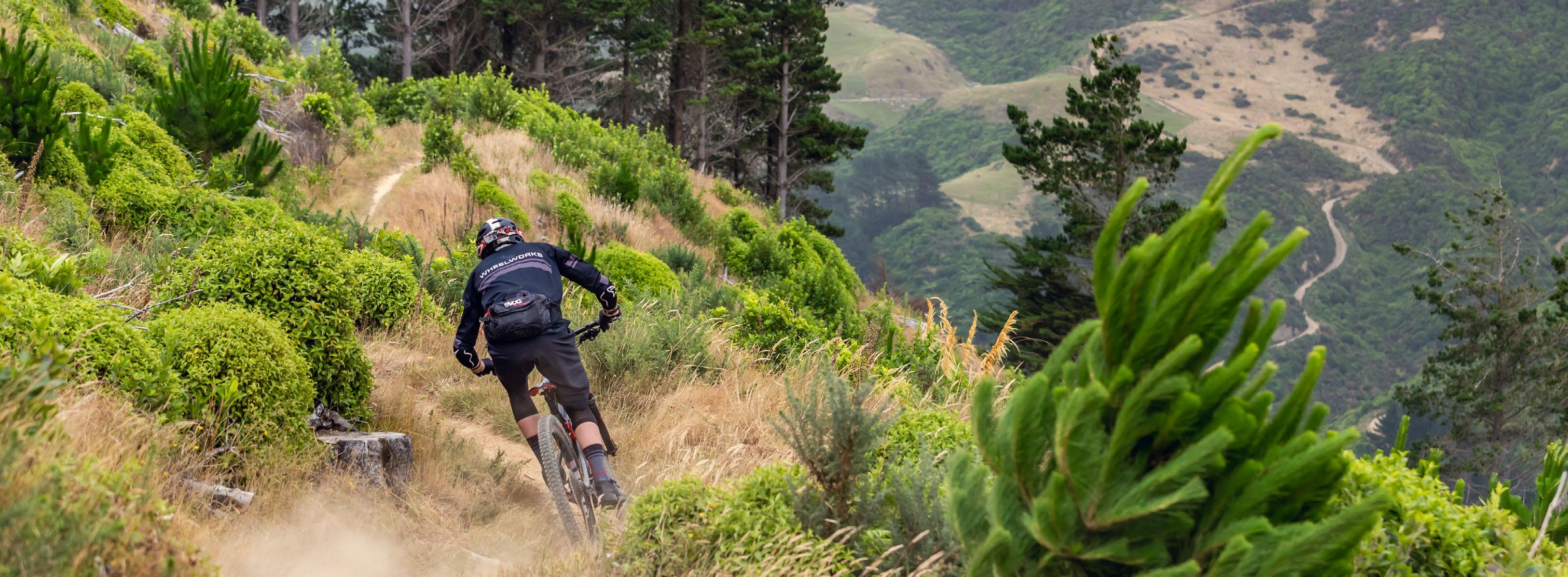
Guardrails / barriers
1
2
Where a significant hazard (such as bluffs) exists and there is no other alternative, a barrier or guardrail shall be provided. Barriers and guardrails shall extend for the full length along which the significant hazard exists
Viewing platforms Viewing platforms may be provided in appropriate places along the trail.
Viewing platforms shall not generally be provided on these trails.
‘Walking’ Steps are undesirable, however may be used as long as less than 1% of track length
Shelters may be provided where there is a significant level of exposure to adverse weather conditions on the most distant parts of the trail. Where shelters are provided, toilets should also be provided at those locations that are popular stops. Toilets should ideally be provided at an interval of not less than 15 km and not greater than 20km apart.
Furniture Seats and picnic tables may be provided.
Seats and picnic tables are not generally provided on these trails.
Ideally include riding times, distances and grid references at entrances, exits and at all junctions. Significant points of interest along or at the end of the trail should be signposted. At locations where there is a jump to a higher grade, signs shall be provided with appropriate symbols and words to describe the change. An orientation/track information sign should be provided at entrances where more than one riding option exists. Trail Type It’s helpful for trail signage to show the trail type: “Technical” typically mean slow speed, rough rooty/rocky surface. “Flow” typically means high speed, smooth surface jumps, rollers and berms.
The trail shall be clearly labeled as one suitable for pedestrians and cyclists by use of appropriate symbols at track entrances and junctions. At junctions where the trails change from dual use to only walking or offroad cycling there shall be appropriate symbols to inform the user
One of the most difficult sections of trail should be at the start, to act as a ‘gateway’ or ‘filter’ that deters riders with not enough skill. Difficult sections should be no more than one grade harder than the overall trail grade. The safest tracks are ‘grade consistent’.
Grade Easiest Grade Easy Grade 3 Intermediate Grade 4 Advanced Grade 5 Expert Grade 6 ExtremeMeasure Fall Height Hf 1.5m out from edge of track, or structure that is <1.5m high, for structures that are between 1.5 and 2m high measure Fall Height at the same distance out from the structure as it is high, For Structures >2m high, measure Fall Height 2m out from the structure edge.
Fall onto a benign surface presenting features that will tend to reduce the effect of impact
(a) Deep moss
(b) Soft vegetation
(c) Shallow still water deep enough to cushion a fall (d) Swamp
Favourable surface presenting features that neither reduce nor amplify the effect of impact
(a) Gravel
(b) Sand
(c) Deep water with reasonable means of exit (d) Grass
Unfavourable surface presenting features that will tend to amplify the effect of impact
(a) Jagged stones
(b) Concrete pavement
(c) Deep water without reasonable means of exit
(d) Sharp vegetation
Hazardous surface presenting features that will result in serious harm, regardless of the effect of fall to the initial impact point
(a) Swiftly flowing water without means of exit
(b) Boiling mud or water
(c)Extended falls arising from rolling or sliding, following initial impact, on terrain whose slope exceeds 35deg.
Mitigating factors such as vegetation likely to arrest rolling shall be taken into account when assessing extended falls
Hf > 2.0m Provide Type A Barrier Hf = 1.0-2.0m Provide Type B barrier Hf < 1.0m no barrier
Hf > 1.5m Provide Type A Barrier Hf = 0.5-1.5m Provide Type B barrier Hf < 0.5m no barrier
Hf > 1.0m Provide Type A Barrier Hf < 1m Provide Type B Barrier
Hf > 3.5m Provide Type A Barrier Hf = 2.0-3.5m Provide Type B barrier Hf < 2.0m no barrier
Hf > 3.0m Provide Type A Barrier Hf = 1.5-3.0m Provide Type B barrier Hf < 1.5m no barrier
Hf > 2.5m Provide Type A Barrier Hf = 1.0-2.5m Provide Type B barrier Hf < 1m no barrier
Hf > 2.0m Provide Type B Barrier Hf <2.0m no barrier
Hf > 2.5m Provide Type C Barrier Hf <2.5m no barrier
Hf > 3.5m Provide Type C Barrier Hf <3.5m no barrier
Hf > 1.5m Provide Type B Barrier Hf < 1.5m no barrier
Hf > 2.0m Provide Type C Barrier Hf < 2.0m no barrier
Hf > 3.0m Provide Type C Barrier Hf < 3.0m no barrier
Hf > 1.0m Provide Type B Barrier Hf<1.0m no barrier
Hf >1.5m Provide Type C Barrier Hf < 1.5m no barrier
Hf > 2.5m Provide Type C Barrier Hf < 2.5m no barrier
Provide Type A Barrier Provide Type A Barrier Provide Type B Barrier Provide Type C Barrier Provide Type C Barrier
Note 1: The above table is derived from SNZ HB 8630:2004 and assumes that the walking user groups identified translate to the MTB trail grades 1-6.
Note2: For tracks and structures with tread width <1.2m it’s recommended that barriers be angled outwards at approx. 5 deg from vertical to allow clearance for handlebars
Note 3: For structures <1.5m in height and not requiring building consent, the following linked references provide ideal construction information and templates: WCC Description and Frame Group Drawings
If openings are present, they shall be small enough to prevent a sphere of 100 mm diameter or greater passing through. Barrier components that are between 150 mm and 760 mm above the deck (or stair nosing) shall be constructed to prevent toeholds from being obtained. The triangular opening formed by the riser, tread and bottom rail at the open side of a stairway shall be constructed so that passage by a 150 mm diameter sphere is prevented.
Openings in type B barriers shall have maximum dimensions of either:
(a) 200 mm horizontally between vertical balusters, or (b) 300 mm vertically (between intermediate rails) with any openings less than 150 mm between the deck and first horizontal rail.
Any openings in type C barriers shall have a maximum dimension of 500 mm vertically (between intermediate rails). There is no maximum dimension between vertical sections.
Grade 1 Easiest Grade 2 Easy Grade 3 Intermediate Grade 4 Advanced Grade 5 & 6 Expert & Extreme
Substrate
0° 1.1° 2.3° 3.4° 4.6° 5.7° 6.8° 8° 9.1° 10.2° 11.3°
Clay loam with high quantity of gravels, stones 65m 49m 37m 27m 20m 15m 11m 7m 5m 2m 2m
Gravelly clay
55m 40m 29m 21m 15m 10m 7m 4m 2.5m 1m
Loam with high quantity of gravels, stones 49m 36m 25m 17m 12m 8m 5m 3m 2m 1m
Clay 44m 32m 23m 16m 10m 7m 4m 2m 1m
Loam 41m 27m 17m 11m 7m 4m 2m 1m
Crushed granite or limestone, with angular particles 20mm, 125mm thick 38m 24m 15m 9m 5m 3m 1m
Organic soil 34m 21m 12m 7m 4m 2m
Sand 30m 17m 9m 5m 2m 1m
Notes:
1. Tread length stated is the distance between a tread crest and the adjacent dip.
2. These values are designed to minimize tread maintenance and minimize tread shape change through erosion
3. Values reflect high splash erosion (no tree canopy)
4. Assumes severe rainfall events of 1-3 times per year. Higher rainfall areas should use shorter tread watershed distances.
5. No tread should have a 0° grade – this column reflects tread grades between 0 and 2°
6. Compacted pure clay while cohesive even on steep grades when dry, is generally too slippery when wet to be practical.
Guidance Notes:
• Grade reversals should be placed at all unbridged water crossings, and at all points where water will flow in heavy rain.
• Grade reversals are also useful for slowing riders down before switchbacks and track junctions.
Half Rule
Soil Type
Gradient should not exceed half the grade of the sideslope – if it does, it is considered fall-line.
Some soils will support steeper grades than others – knowing the cohesion and drainage properties of the soil is important
Rock Solid rock trails will support steeper grades.
Annual Rainfall
Grade Reversals
Very high and very low rainfall areas may need to be designed with gentler grades
Frequent grade reversals will allow for slightly steeper grades
Type of Users Walkers and Mountain bikers are generally low impact users. If high impact users share the trail, more gentle grades should be considered
Number of Users
High use trails may need more gentle grades
Difficulty Level Grade 4-6 trails with a desired higher difficulty level may be steeper, but techniques such as frequent grade reversal and tread armouring may be essential to ensure sustainability
Photography by visualsby.me

